| Previous :: Next Topic |
| Author |
Message |
puzzlr
Mid Fork Rocks


Joined: 13 Feb 2007
Posts: 7220 | TRs | Pics
Location: Stuck in the middle |
|
puzzlr
Mid Fork Rocks
|
 Mon Oct 12, 2020 9:22 pm |
|
|
I first climbed Russian Butte in 2015 solo via the Granite Lakes route with an overnight near Thompson Point. That way doesn't present difficulties other than the length, lack of water, and finding a good route up the summit block. Some do that route in a really long day (2008 in 17.5 hours and 2016 in 21 hours). Outside and Stuff has an excellent video on YouTube
The prospect of a quicker trip via the Pratt has intrigued me for a long time but I was nervous about bushwhacking 3500' up the east side just to get to the summit block. The only report here on the Pratt route is this 2010 trip that took almost 19 hours!. This route requires fording both the Middle Fork and Pratt Rivers so doing it in the fall when the Middle Fork gage reads close to 1 foot is best -- that makes the ford at the Pratt River Bar only knee high.
Bryan and I started from the Pratt River Bar at 7am and quickly crossed the Middle Fork in water shoes then put on our boots. The Pratt River trail is familiar to me because I spent a few days on a WTA BCRT a few years ago brushing and clearing blow down. Our plan was to cross Trestle Creek and then drop down to the Pratt where we could pick up the desired ridge on the other side. This worked out well although we had to scout around to find a decent rock hop across the Pratt -- it had a lot more water in October than I expected.
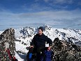
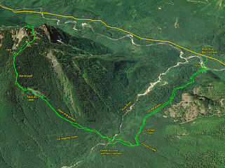 GPS track from our trip 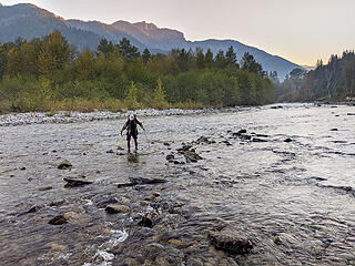 Fording the low running Middle Fork River. Only 350 cfs and 1.8 feet at the gage. Here (4 miles upstream) the flow would be the same but only just over knee high for a few steps while in a channel. 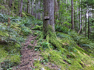 Trail split at the Big Trees sign. We took the upper trail to get onto the old RR grade 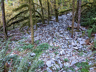 A fresh gravel run came down last winter and partially covered the RR grade 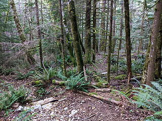 2 miles up the Pratt River trail it zig-zags uphill a bit to cross Trestle Creek. The RR used to cross a since fallen trestle here, hence the name. We hiked to the far side and headed down to the Pratt River from this flat landing. 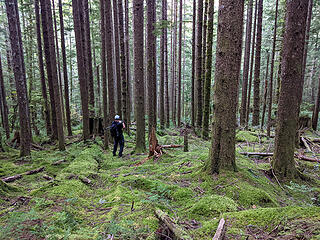 A spongy moss forest floor made for a mostly easy descent to the river 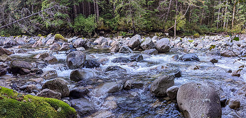 Pratt River where we first intercepted it. We didn't see a reasonable rock hop here so we went upstream about 200' 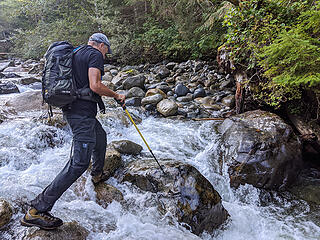 The Pratt River was channeled into some gaps between big rocks here. The rocks were wet and a little slippery but we made it work. We found an easier crossing further upstream on the way out. 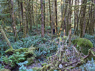 Once across the Pratt River we had 3500' of gain through forest just to get to the final summit climb. We expected a lot of brush but right off we only had to make our way through a forest filled with very healthy sword ferns. 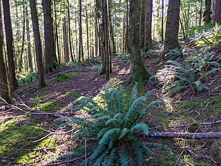 Crossing the third caterpiller logging road at ~1550' 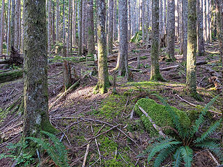 Open second growth forest at 1700' 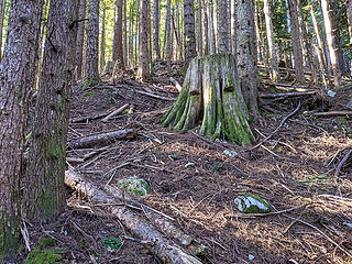 Springboard stump at 2100', still open forest 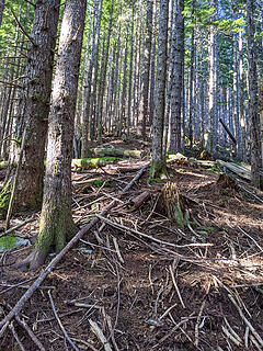 Continuing open second growth forest at 2300' 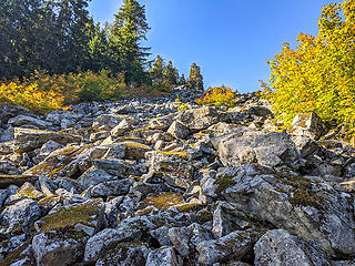 Looking up the talus field from it's lower end at 3000' 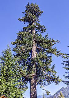 Big douglas fir at the talus field. Most were not this size, despite it being well above the upper limit of logging 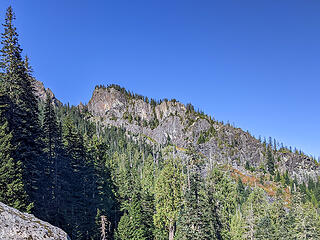 My first ever look at the cliff that terminated the pyramid shaped subpeak on the east side of Russian Butte. I've wanted to get a look at this for a long time. 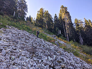 Nearing the top of the talus field after 400' elevation gain from the bottom. Our route went left before the very end to catch a steep part of the ridge leading up 200' to a the narrowest ridge on the whole trip -- kind of like a rooster comb. 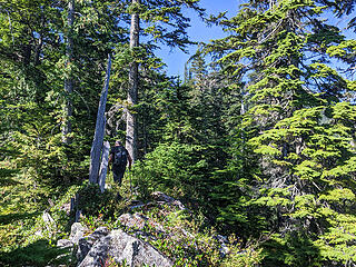 On the rooster comb ridge above the talus field at 3450' 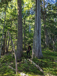 At 3600' the ridge flattens out for a while and has some surprsingly large trees for this elevation. The three biggest in the photo are a hemlock, cedar, and douglas fir. 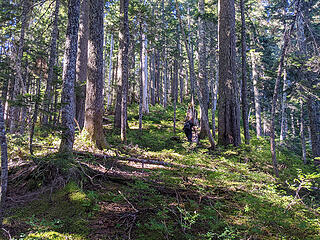 At 3800' we started to get into the blueberry zone which continued all the up to the base of the summit block 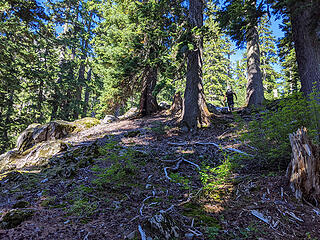 We broke into more open forest again near the base of the summit block at 4100', but still 1000' below the summit 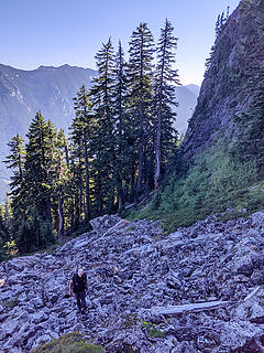 At 4150' we swung around below this big rock prow at the base of the NE ridge and headed up talus slope toward the ridge line 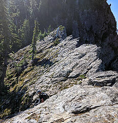 This is where we crested the ridge. It was the wrong spot but the scenery was dramatic. 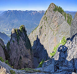 View down into the spectacluarly rugged gully betwee the main and north peak 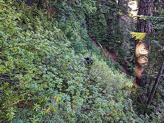 A short steep blueberry choked passage through the cliffs is the crux of this route. There are other ways up but this 5-minute effort is the only spot here with any danger of falling. 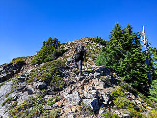 The NE slopes break out onto this ridge just below the summit 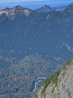 The February 2020 Bessemer mud flow is visible across the valley 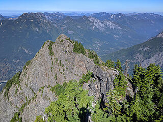 North peak of Russian Butte 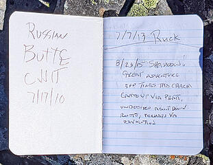 Russian Butte register book 1 placed in 2010 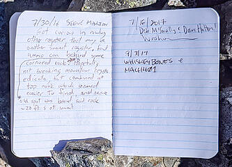 Russian Butte register book 1 placed in 2010 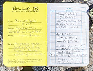 Russian Butte register book 2 placed in 2015 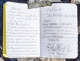 Russian Butte register book 2 placed in 2015 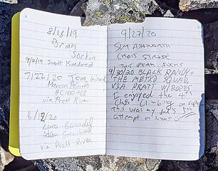 Russian Butte register book 2 placed in 2015 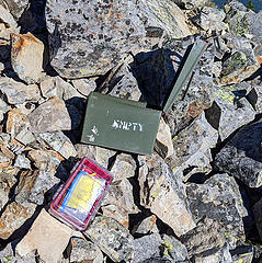 I replaced the baggies and water bottle containers with a new Pelican case. It fit perfectly inside the ammo box so this register is well protected now. 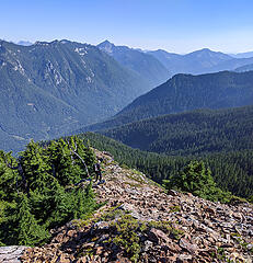 Descending the north ridge off the summit. The easy way down drops left at the farthest rocky area visible 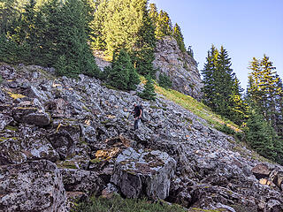 Rounding the 4150' rock prow on the way down 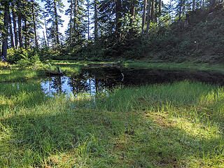 We diverted briefly to the small pond at 4100' to refill our water bottles for the trip down. 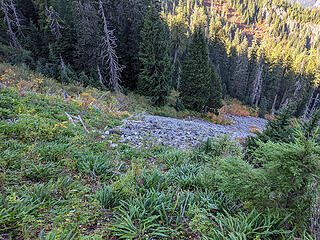 Back to the top of the talus slope 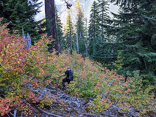 At the bottom of the talus slope we had to bushwhack through the vine maple. Below the vine maple there is a short section of scrub hemlocks which are annoying. 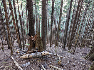 Not far below the talus the forest floor becomes bare in the second growth and stays like this for nearly 2000' 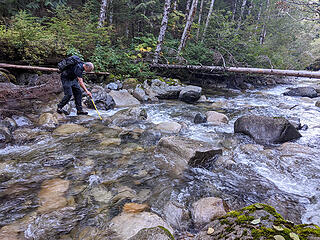 Crossing the Pratt 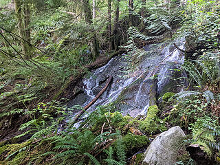 Ginger Falls 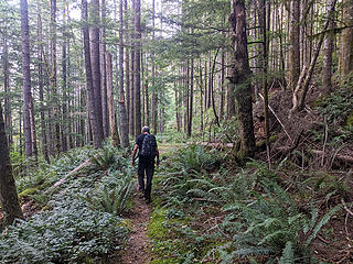 Walking out the pleasantly flat Pratt River RR grade 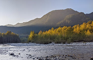 Finally we reach the Middle Fork river again at 5:45 pm, about an hour before sunset. 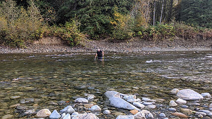 Crossing the Middle Fork river to the Pratt River bar 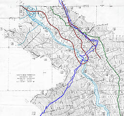 Our route superimposed on the 1937 Pratt cruiser map. Our crossings were really close to the location of the big switchback of the NBTC logging RR
|
| Back to top |
  
|
|
RichP
Member

Joined: 13 Jul 2006
Posts: 5634 | TRs | Pics
Location: here |
|
RichP
Member
|
Mon Oct 12, 2020 9:33 pm |
|
|
Oooh.. I like this route. I remember you talking about it. Glad it worked out well.
|
| Back to top |
|
|
Cyclopath
Faster than light

Joined: 20 Mar 2012
Posts: 7732 | TRs | Pics
Location: Seattle |
|
Cyclopath
Faster than light
|
Mon Oct 12, 2020 9:42 pm |
|
|
That river must have been chilly? What a towering and seldom visited peak!
|
| Back to top |
|
|
cascadeclimber
Member
Joined: 04 Sep 2006
Posts: 1427 | TRs | Pics
|
Great adventure outing. This one has been on my list for a long while.
|
| Back to top |
|
|
awilsondc
Member

Joined: 03 Apr 2016
Posts: 1324 | TRs | Pics
|
Nice trip! Thanks for posting some beta on this route, it seems like an appealing alternative to the longer route so many take. Man, this is a tough peak! Great job getting it done. 
|
| Back to top |
|
|
OutOfOffice
Member

Joined: 02 Jun 2015
Posts: 91 | TRs | Pics
Location: Seattle |
Your TR reminded me of this peak! I haven't climbed it yet, but now excited to have another sizable peak in the north bend area to bag. Both routes sound fun
|
| Back to top |
|
|
Now I Fly
Member
Joined: 07 Jun 2018
Posts: 465 | TRs | Pics
|
Sorry I missed it, but so glad you two got it done!
Good job!!!
Excellent TR, Monty!
|
| Back to top |
|
|
MangyMarmot
Member

Joined: 06 Apr 2012
Posts: 474 | TRs | Pics
|
Nice trip! That's an interesting peak. I've looked upon it many times but I have not headed up there yet.
|
| Back to top |
|
|
Rob
Member
Joined: 12 Feb 2006
Posts: 14 | TRs | Pics
Location: Bothell, WA |
|
Rob
Member
|
Wed Oct 14, 2020 8:56 pm |
|
|
From Russian Butte in August 1972 via Pratt river
|
| Back to top |
|
|
Snowdog
Member

Joined: 21 Jul 2006
Posts: 1028 | TRs | Pics
Location: on (& off) the beaten path |
|
Snowdog
Member
|
Fri Oct 16, 2020 10:13 am |
|
|
great trip report! I *think* I'm sorry to have missed. 
'we don't have time for a shortcut'
'we don't have time for a shortcut'
|
| Back to top |
|
|
Zloi
Member

Joined: 30 Sep 2009
Posts: 129 | TRs | Pics
Location: Burien, haven for the helpless & homeless |
|
Zloi
Member
|
Wed Oct 28, 2020 8:14 pm |
|
|
This is a wonderfully done documentary of your trip. Part of me has been itching for years to give Russian Butte a try. Fortunately, the more rational, self-preservation part of me has won out to this point. But congrats on a significant accomplishment.
|
| Back to top |
|
|
|
|


