| Previous :: Next Topic |
| Author |
Message |
Eric Gilbertson
Member


Joined: 04 Jul 2018
Posts: 188 | TRs | Pics
Location: Seattle |
Colchuck Peak (8,705 ft) via South Face
Dec 12-13, 2020
Eric and Damon
27 miles (10 miles snowmobiling, 12 miles skiing, 5 miles booting)
I was looking to do a shakedown trip to test out my snowmobile with overnight and ski gear before bigger trips this winter. Id previously climbed Colchuck a few times, from both the north and south, but Damon still needed Colchuck to get closer to completing the Bulgers list. Colchuck fit the bill for me as a good test trip since it could involve the snowmobile, skis, and overnight gear, and I was already familiar with the main routes so could focus more on testing out new gear.
Interestingly, Damon and I had each bailed four times trying Colchuck. For me the first time in November 2015 I got to the col above the Colchuck Glacier and bailed due to bad weather. Then in December 2015 a fresh snowstorm slowed progress down too much and I turned around before Colchuck Lake. I successfully climbed it in February 2016 on snowshoes via the Colchuck Glacier as a 16hr car-to-car hike. Then in September 2018 I was trying to tighten my Bulger completion time and attempted the Colchuck Glacier route, but bailed since the bergschrund was melted out and impassable. The next day I tried to go up the south face route but bailed in a heavy rainstorm. Finally the next day I climbed it as a day trip via the south face. So in all Ive bailed on Colchuck four times and climbed it twice.
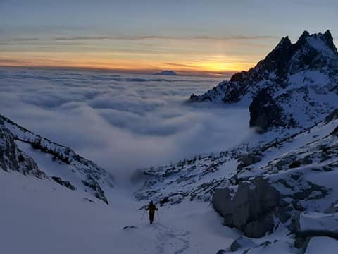 Descending from the summit at sunset 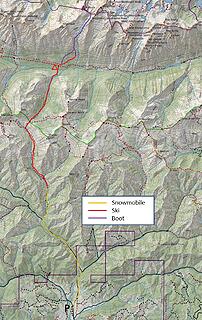 The route 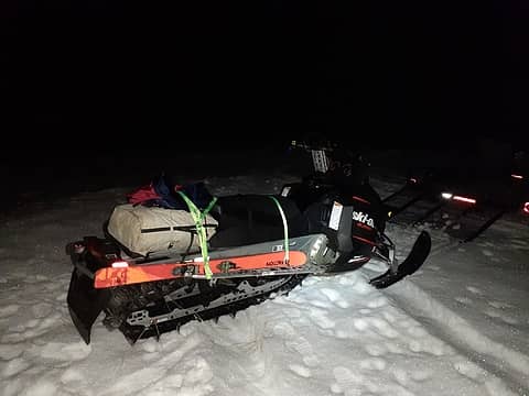 Loading up the sled at 29 Pines 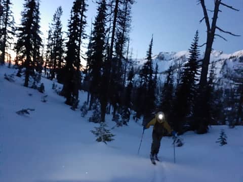 Approaching the pass leading to Fourth Creek 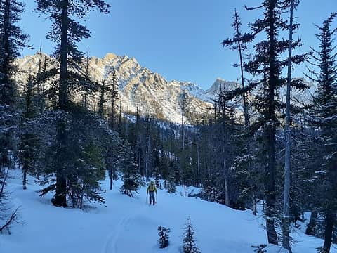 Skiing down Fourth Creek 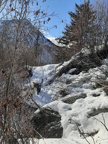 Bushwhacking up the south face 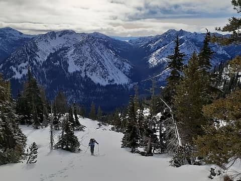 Booting up more open terrain 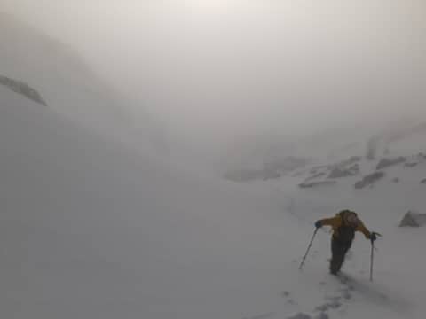 Socked in a whiteout up high 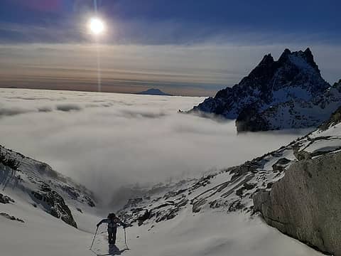 Breaking out above the clouds with Adams, Rainier, Argonaut poking out 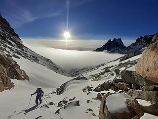 Hiking above the clouds 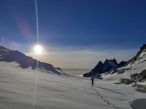 Nearing the col 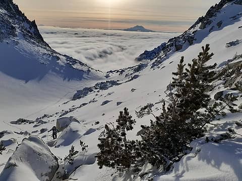 Looking down from above the col 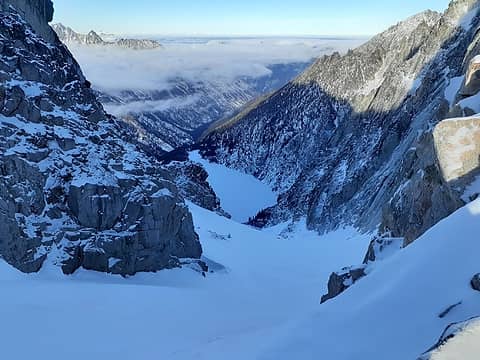 Looking down the Colchuck Glacier to Colchuck Lake 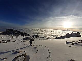 Hiking across the summit plateau 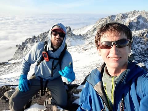 On the summit 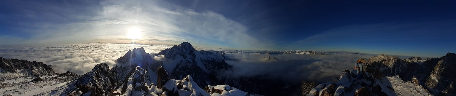 Summit panorama 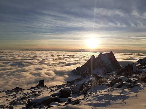 Heading back down 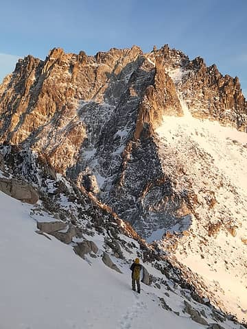 Descending to the col, looking towards Dragontail 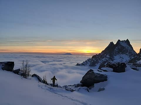 Dropping back below the clouds 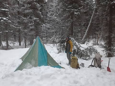 Camp at Ingalls Creek 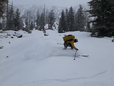 Skiing out Beverly Creek 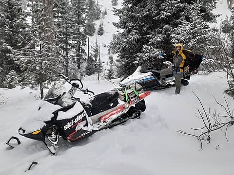 Back at the snowmobiles 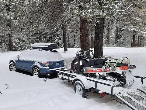 Loading up back at 29 Pines
|
| Back to top |
  
|
|
fourteen410
Member

Joined: 23 May 2008
Posts: 2629 | TRs | Pics
|
Interesting route, thanks for sharing. Small world - I went to jr. & high school with your climbing partner's GF.
|
| Back to top |
|
|
Gimpilator
infinity/21M

Joined: 12 Oct 2006
Posts: 1684 | TRs | Pics
Location: Edmonds, WA |
| Eric Gilbertson wrote: | Breaking out above the clouds with Adams, Rainier, Argonaut poking out |
That's the stuff. It's great to see a trip of this magnitude in Dec. Good idea on the snow mobile. 
|
| Back to top |
|
|
RichP
Member

Joined: 13 Jul 2006
Posts: 5634 | TRs | Pics
Location: here |
|
RichP
Member
|
 Wed Dec 16, 2020 6:41 am |
|
|
A snowmobile and skis; there's nowhere you can't go now. 
|
| Back to top |
|
|
zephyr
aka friendly hiker

Joined: 21 Jun 2009
Posts: 3370 | TRs | Pics
Location: West Seattle |
|
zephyr
aka friendly hiker
|
Wed Dec 16, 2020 10:11 am |
|
|
Great story. An excellent adventure with so many moving parts. Well done. The video was fun to see--especially the creek crossing. haha Loved the undercast sky panorama view and the cascade of clouds off Sherpa. Thank you. ~z
|
| Back to top |
|
|
Nancyann
Member
Joined: 28 Jul 2013
Posts: 2319 | TRs | Pics
Location: Sultan Basin |
|
Nancyann
Member
|
Wed Dec 16, 2020 10:26 pm |
|
|
Nice that you now have a snowmobile Eric. Definitely an upgrade from pulling a real sled behind you while skiing. Although Im not sure how well it would go trying to use your snowmobile to get up the North Fork Entiat Road like you did last winter on skis, climbing over a hundred blowdowns. I think we saw your ski tracks across a blowdown when we went up there last winter.
Did you use a GoPro on your Colchuck trip?
|
| Back to top |
|
|
Backpacker Joe
Blind Hiker

Joined: 16 Dec 2001
Posts: 23956 | TRs | Pics
Location: Cle Elum |
Great report. Well, what I could see of it anyway. LOL. So, I guess there wasn't ONE THOUSAND people up there like there was everyday this July and August aye???
"If destruction be our lot we must ourselves be its author and finisher. As a nation of freemen we must live through all time or die by suicide."
Abraham Lincoln
"If destruction be our lot we must ourselves be its author and finisher. As a nation of freemen we must live through all time or die by suicide."
Abraham Lincoln
|
| Back to top |
|
|
Blowdown
Sawin' Logs ...

Joined: 24 Aug 2011
Posts: 376 | TRs | Pics
Location: On the Summit |
|
Blowdown
Sawin' Logs ...
|
Thu Dec 17, 2020 10:08 am |
|
|
|
| Back to top |
|
|
Tom
Admin
Joined: 15 Dec 2001
Posts: 17853 | TRs | Pics
|
|
Tom
Admin
|
Thu Dec 17, 2020 2:33 pm |
|
|
Fantastic stuff. Thanks for posting.
|
| Back to top |
|
|
Downhill
Member
Joined: 30 Jul 2018
Posts: 341 | TRs | Pics
Location: Leavenworth |
|
Downhill
Member
|
Thu Dec 17, 2020 6:50 pm |
|
|
Great trip, great trip report, and outstanding pix - thanks and congrats!
I just finished servicing and tuning my sleds for the season - your TR got me syched for some upcoming winter adventures!!
Thanks for your post!
|
| Back to top |
|
|
Eric Gilbertson
Member
Joined: 04 Jul 2018
Posts: 188 | TRs | Pics
Location: Seattle |
| Quote: | | Im not sure how well it would go trying to use your snowmobile to get up the North Fork Entiat Road like you did last winter on skis, climbing over a hundred blowdowns. |
Yes, that road had tons of blowdowns! Did you ski up there too last winter? I do remember seeing some snowmobile tracks that went to that trailhead, so somehow someone managed to get around them all. Not sure if I'm skilled enough to do that yet.
| Quote: | | Did you use a GoPro on your Colchuck trip? |
I wish I had, but I just used my phone for everything. Probably a better idea to go hands free and mount a GoPro in the future though.
| Quote: | | So, I guess there wasn't ONE THOUSAND people up there like there was everyday this July and August aye??? |
I didn't see anyone else the whole trip except on the road. I don't expect the south route on Colchuck will ever see too much traffic given the bushwhacking component. But it does have the advantage that you don't have to worry about glacier travel.
|
| Back to top |
|
|
Nancyann
Member
Joined: 28 Jul 2013
Posts: 2319 | TRs | Pics
Location: Sultan Basin |
|
Nancyann
Member
|
Thu Dec 17, 2020 11:44 pm |
|
|
We walked in the snow up the N. Fork Entiat Road to the trailhead in late winter, just looking for a place to go where there were no people. It certainly fit the bill. I had read your trip report from February and knew you had skied up. Not surprisingly, no one else had made any other entries in the trailhead register after you, until we got there.
|
| Back to top |
|
|
puzzlr
Mid Fork Rocks

Joined: 13 Feb 2007
Posts: 7220 | TRs | Pics
Location: Stuck in the middle |
|
puzzlr
Mid Fork Rocks
|
Sun Dec 20, 2020 12:42 am |
|
|
This was a really fun report to read. Thanks for posting. I enjoyed the photos but also the time compression in the video. If I could ski I would love a trip like this. Oh well 
|
| Back to top |
|
|
chandlerhaberlack
chandler haberlack

Joined: 29 May 2018
Posts: 26 | TRs | Pics
Location: Monroe |
saw Damon's story on instagram when you guys did it. what amazing views!
|
| Back to top |
|
|
MangyMarmot
Member

Joined: 06 Apr 2012
Posts: 474 | TRs | Pics
|
Awesome trip guys! Great photos!
|
| Back to top |
|
|
|
|
You cannot post new topics in this forum
You cannot reply to topics in this forum
You cannot edit your posts in this forum
You cannot delete your posts in this forum
You cannot vote in polls in this forum
|
Disclosure: As an Amazon Associate NWHikers.net earns from qualifying purchases when you use our link(s). |


