| Previous :: Next Topic |
| Author |
Message |
Foist
Sultan of Sweat


Joined: 08 May 2006
Posts: 3974 | TRs | Pics
Location: Back! |
|
Foist
Sultan of Sweat
|
 Fri Jan 22, 2021 9:59 am |
|
|
I've never been to La Bohn Gap but I've considered going there, and I was always confused by how the map didn't seem to match up to the Harvey Manning 100 Hikes description. Now I know why!
The new TF layer on Caltopo is also really interesting. Does anyone know how it's compiled and how it differs from the Mapbuilder layer?
|
| Back to top |
  
|
|
Gil
Member

Joined: 29 Sep 2004
Posts: 4062 | TRs | Pics
|
|
Gil
Member
|
Sun Jan 24, 2021 12:47 pm |
|
|
| timberghost wrote: | | That's better because you have to go below La Bohn Gap. Then would have to drop down to Chain Lakes, Williams, etc. |
I suppose that would be true if you went the wrong way (far right) before reaching the top of the pass and La Bohn Lakes.
Friends help the miles go easier.
Klahini
Friends help the miles go easier.
Klahini
|
| Back to top |
|
|
Randito
Snarky Member

Joined: 27 Jul 2008
Posts: 9512 | TRs | Pics
Location: Bellevue at the moment. |
|
Randito
Snarky Member
|
Sun Jan 24, 2021 2:35 pm |
|
|
FWIW: When my son and I climbed Mt Hinman in 2003, we camped at Williams Lake, hiked up though Chain Lakes to the pass between Chain Lakes and La Bohn Lake and then headed east up Hinman. Fred Becky in the Cascade Alpine Guide refers to this pass as "La Bohn Gap"
La Bohn Lake lies NE of this gap and La Bohn Peak lies SW.
In older USGS maps of the area the "L" of "La Bohn Gap" is shown on the saddle between Chain Lakes and La Bohn Lake and the center of the text "La Bohn Gap" lies on the saddle between Chain Lakes and Lake Rowena.
The terrain between that saddle and Lake Rowena is very steep and not particularly useful as a travel route and there aren't any mines in the Lake Rowena basin that the miners would have been travelling to and from. There are numerous mines in the Chain Lakes area. There is old mining equipment and mines in the Necklace Valley.
So which is easier to believe: 1) That miners labeled a pass they didn't use very much and off to the side of their usual travel route with the same name as closer by features. 2) A USGS clerk in the 1960s who had never visited the area made a mistake placing a label on a newer higher resoution map.
|
| Back to top |
|
|
Sky Hiker
Member

Joined: 03 Feb 2007
Posts: 1469 | TRs | Pics
Location: outside |
|
| Back to top |
|
|
Randito
Snarky Member
Joined: 27 Jul 2008
Posts: 9512 | TRs | Pics
Location: Bellevue at the moment. |
|
Randito
Snarky Member
|
Sun Jan 24, 2021 6:07 pm |
|
|
You may inspect the historical USGS maps of the area yourself
https://ngmdb.usgs.gov/topoview/viewer/#14/47.5605/-121.2373
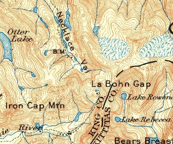
Here is an inset of the 1902 map where the "L" of "La Bohn Gap" lies on the saddle between Chain Lakes and La Bohn Lakes -- notice too the shapes of Williams lake and Lake Rowena are significantly different from modern maps. Also note that the "I" in "Iron Cap Mtn" is on the summit. That name isn't centered on the summit.
 Historical Topographic Map Collection
|
| Back to top |
|
|
Randito
Snarky Member
Joined: 27 Jul 2008
Posts: 9512 | TRs | Pics
Location: Bellevue at the moment. |
|
Randito
Snarky Member
|
Sun Jan 24, 2021 6:19 pm |
|
|
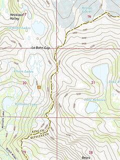
Since 2017 the updated USGS topo maps show La Bohn Gap as the pass between Chain Lakes and La Bohn Lakes -- you can inspect using the link above or just look at this inset
 US Topographic Map Collection
|
| Back to top |
|
|
timberghost
Member
Joined: 06 Dec 2011
Posts: 1328 | TRs | Pics
|
|
| Back to top |
|
|
BigBrunyon
Member
Joined: 19 Mar 2015
Posts: 1456 | TRs | Pics
Location: the fitness gyms!! |
The real situation is that there are two different la bohn gaps
|
| Back to top |
|
|
Carbonj
Member
Joined: 12 May 2020
Posts: 56 | TRs | Pics
|
|
Carbonj
Member
|
Sun Jan 24, 2021 10:49 pm |
|
|
I believe what our father in heaven, Fred Becky wrote.
|
| Back to top |
|
|
timberghost
Member
Joined: 06 Dec 2011
Posts: 1328 | TRs | Pics
|
| Carbonj wrote: | | Okay I looked at the map, La bohn gap goes to the east to rowena lake, I accessed mt hinman on a ski trip that way. I'm right dammit. |
Of coarse you are
|
| Back to top |
|
|
Carbonj
Member
Joined: 12 May 2020
Posts: 56 | TRs | Pics
|
|
Carbonj
Member
|
Tue Jan 26, 2021 8:30 am |
|
|
| timberghost wrote: | | Of coarse you are |
Hey I skied icy slopes all that day, fending off red bull induced teens, sucked down a KBS stout. I'm old and ornery and I will try and keep from cussin in the future. 
|
| Back to top |
|
|
FiveNines
Member
Joined: 01 Oct 2010
Posts: 526 | TRs | Pics
|
| timberghost wrote: | | Of coarse you are |
Such course language.
|
| Back to top |
|
|
timberghost
Member
Joined: 06 Dec 2011
Posts: 1328 | TRs | Pics
|
|
| Back to top |
|
|
|
|


