| Previous :: Next Topic |
| Author |
Message |
rubywrangler
Member


Joined: 04 Aug 2015
Posts: 511 | TRs | Pics
|
Still trying to catch up on the road trip hikes... hard to do from the road  This trip was a plan B due to limited transportation within Grand Canyon currently - shuttle service is reduced and the usual taxi service is not running due to covid. The Boucher ("booshay") trail is described by the NPS as "one of the most difficult and demanding of the south side trails" and "best left to experienced canyon hikers". Their two-page trail description also says, "Expectations should be low and navigation skills high."
  This all made me a little nervous since my total grand canyon hiking experience consisted of one overnight and one dayhike last fall. I was also worried about annoying helicopter noise since much of this route is within the "dragon corridor" where sightseeing flights are permitted. The first concern ended up being totally unnecessary, and I got lucky with helicopters because of weather. It turned out to be an incredible trip!
In the process of getting a permit, I received several form emails from the GNCP rangers/ fearmongers that seemed designed to scare me out of my itinerary. One of their stated concerns was that my first day itinerary (Hermit trail to Hermit rapids) was too ambitious. I didn't really understand why because it was only 8 miles or so, and I had hiked up the Hermit trail in <5 hours last year. Nonetheless, I stayed at Yavapai Lodge in the park on the night before the trip, so I could get a (relatively) early start. The lodge looks like a barracks from the outside but the rooms are updated and actually pretty decent. However they were not broadcasting the Steelers-WFT game so I had to stream it thru my phone from a parking lot instead of watching it on the huge TV in my room. But thank you Visible/Verizon!
I hit the trail from Hermit's Rest at 8:30 on Tuesday morning and made it to the Tonto before noon. From that point my pace slowed considerably because 1) I only had a couple miles down to the river and 5+ hours of daylight and 2) the trail down to Hermit Rapids is so lovely. I made a side trip to check out the ruins of Hermit camp (1920s era luxury campsite with a tram from the rim), then took my time, and many many photos, hiking down Hermit creek. Made it to the Colorado in time to catch a little sun on the river, but not much. So pretty! Shortly after I arrived at the beach, two groups of rafters and kayakers came through the rapids. It looked so fun, and so terrifying. I set up camp east of hermit creek and explored the beach for awhile. Like my last trip to the Grand Canyon, it was clear that the place is full of rodents - tiny footprints were everywhere, and they ran circles around (and up and over) my tent all night. Aside from the mice, I had whole place to myself. This all made me a little nervous since my total grand canyon hiking experience consisted of one overnight and one dayhike last fall. I was also worried about annoying helicopter noise since much of this route is within the "dragon corridor" where sightseeing flights are permitted. The first concern ended up being totally unnecessary, and I got lucky with helicopters because of weather. It turned out to be an incredible trip!
In the process of getting a permit, I received several form emails from the GNCP rangers/ fearmongers that seemed designed to scare me out of my itinerary. One of their stated concerns was that my first day itinerary (Hermit trail to Hermit rapids) was too ambitious. I didn't really understand why because it was only 8 miles or so, and I had hiked up the Hermit trail in <5 hours last year. Nonetheless, I stayed at Yavapai Lodge in the park on the night before the trip, so I could get a (relatively) early start. The lodge looks like a barracks from the outside but the rooms are updated and actually pretty decent. However they were not broadcasting the Steelers-WFT game so I had to stream it thru my phone from a parking lot instead of watching it on the huge TV in my room. But thank you Visible/Verizon!
I hit the trail from Hermit's Rest at 8:30 on Tuesday morning and made it to the Tonto before noon. From that point my pace slowed considerably because 1) I only had a couple miles down to the river and 5+ hours of daylight and 2) the trail down to Hermit Rapids is so lovely. I made a side trip to check out the ruins of Hermit camp (1920s era luxury campsite with a tram from the rim), then took my time, and many many photos, hiking down Hermit creek. Made it to the Colorado in time to catch a little sun on the river, but not much. So pretty! Shortly after I arrived at the beach, two groups of rafters and kayakers came through the rapids. It looked so fun, and so terrifying. I set up camp east of hermit creek and explored the beach for awhile. Like my last trip to the Grand Canyon, it was clear that the place is full of rodents - tiny footprints were everywhere, and they ran circles around (and up and over) my tent all night. Aside from the mice, I had whole place to myself.
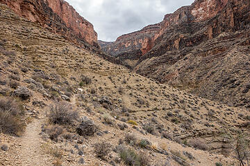
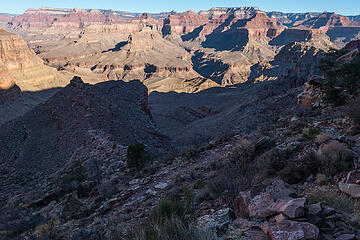 hermit trail 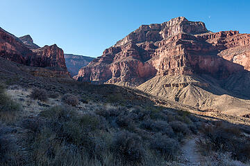 columbus point 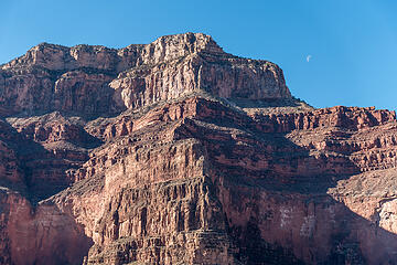 columbus point 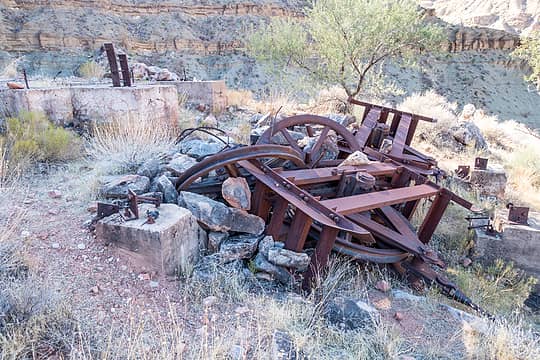 hermit camp ruins 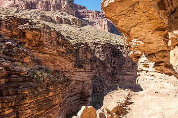 hermit creek trail 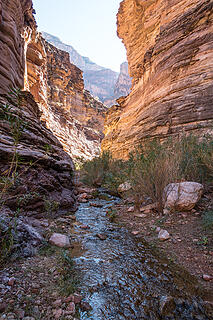 hermit creek 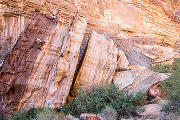 massive boulders along the hermit creek trail  hermit creek trail 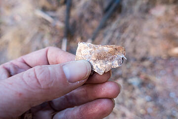 doug, what is this? 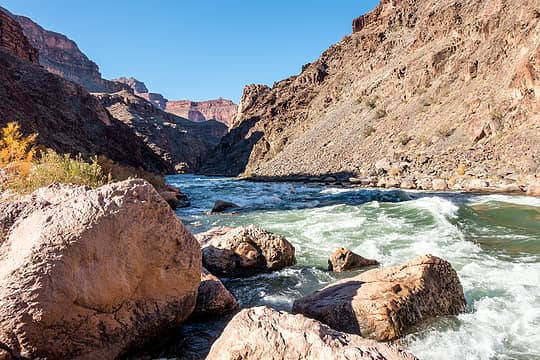 hermit rapids 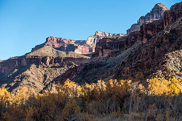 view from hermit beach 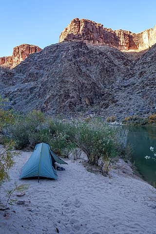 hermit rapids camp 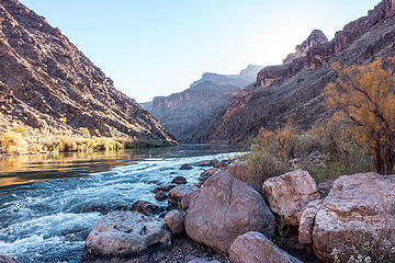 pretty morning 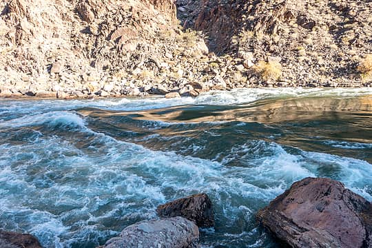 hermit rapids 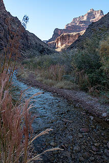 hermit creek 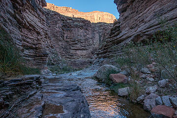 hermit creek 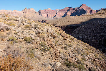 tonto views 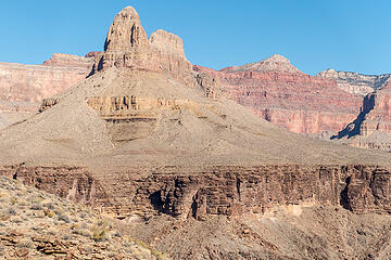 tonto views 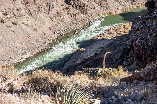 tonto views 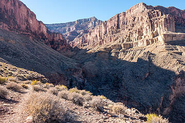 entering travertine canyon 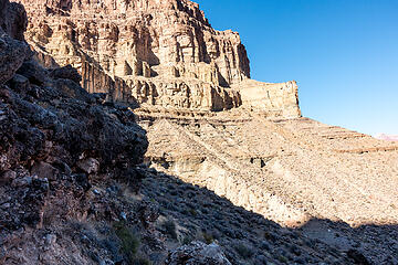 tonto views 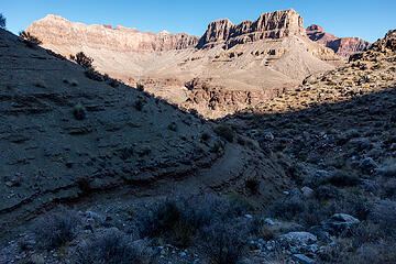 tonto views 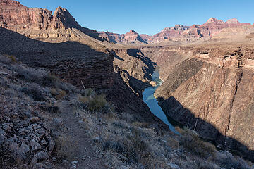 tonto views 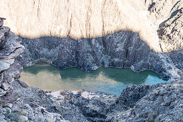 tonto views 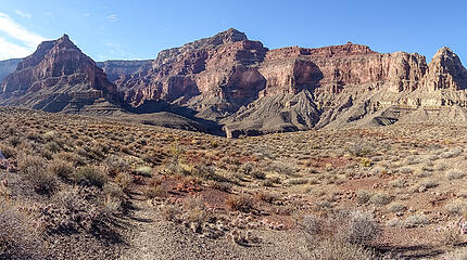 tonto views 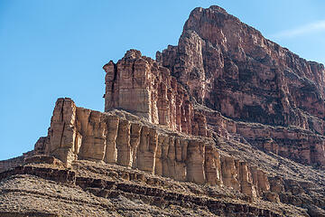 whites butte 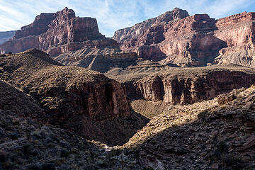 on the tonto above boucher camp 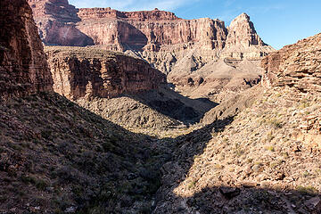 dropping into boucher creek 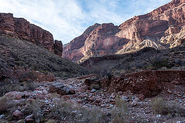 boucher creek 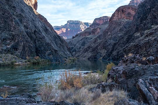 looking upstream 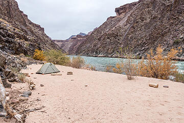 boucher rapids camp  Although I didnt see any mice, I still woke up to a pitter-patter sound in the middle of the night and after a confused few minutes, realized it was raining. Hmm, this was not in the forecast and I hadnt brought rain gear. But I figured it would clear up by morning and went back to sleep. When I woke up it was still drizzling off and on but the sun was poking through intermittently. I sat and read and waited awhile for the sun to hit the beach, but gave up eventually. Today would be the hardest day, with a couple steep climbs and a scramble through the Supai, and I had to carry 2 days worth of water to my next camp on Yuma point. It was also dragon corridor day, but so far the weather seemed to be putting a damper on the helicopter traffic.
I hiked back up Boucher creek to Boucher camp, filled up water, and headed up the Boucher trail. The trail makes a steep traverse and then goes up a short, steeper gully to Whites Butte saddle, but there is a good trail the whole way. Mr. Boucher used to take burros up and down this route. As I climbed, it was clear that the sun was not going to win the battle. I watched the clouds and mist gather and darken around the pinnacles behind me, it was quite a sight. By the time I reached the saddle, it was drizzling. The trail stays level for awhile as it goes back through Travertine canyon, and then climbs some more. But the beginning of the second climb it was raining steadily, so I took a break under the overhang of a large boulder for about 20 minutes until the rain stopped.
Although I didnt see any mice, I still woke up to a pitter-patter sound in the middle of the night and after a confused few minutes, realized it was raining. Hmm, this was not in the forecast and I hadnt brought rain gear. But I figured it would clear up by morning and went back to sleep. When I woke up it was still drizzling off and on but the sun was poking through intermittently. I sat and read and waited awhile for the sun to hit the beach, but gave up eventually. Today would be the hardest day, with a couple steep climbs and a scramble through the Supai, and I had to carry 2 days worth of water to my next camp on Yuma point. It was also dragon corridor day, but so far the weather seemed to be putting a damper on the helicopter traffic.
I hiked back up Boucher creek to Boucher camp, filled up water, and headed up the Boucher trail. The trail makes a steep traverse and then goes up a short, steeper gully to Whites Butte saddle, but there is a good trail the whole way. Mr. Boucher used to take burros up and down this route. As I climbed, it was clear that the sun was not going to win the battle. I watched the clouds and mist gather and darken around the pinnacles behind me, it was quite a sight. By the time I reached the saddle, it was drizzling. The trail stays level for awhile as it goes back through Travertine canyon, and then climbs some more. But the beginning of the second climb it was raining steadily, so I took a break under the overhang of a large boulder for about 20 minutes until the rain stopped.
 up the boucher trail 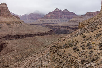 boucher trail, above the tonto 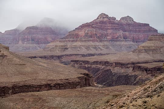 cloudy 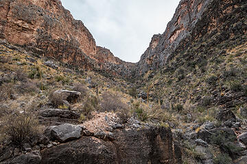 gully to whites butte saddle in the distance 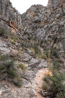 gully ahead 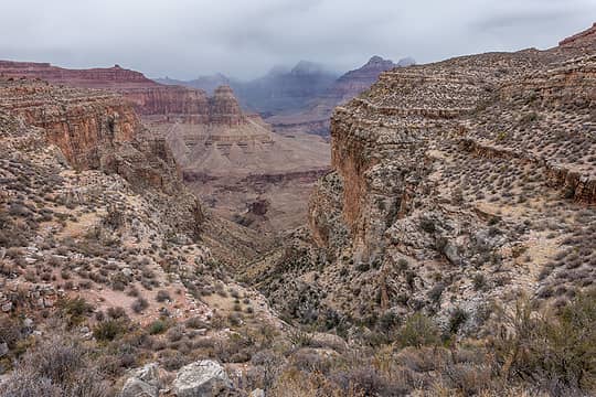 looking back down the boucher trail from whites butte saddle 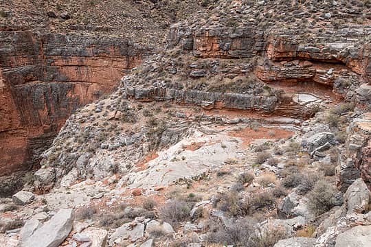 travertine canyon 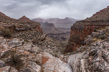 moody 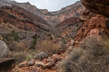 travertine canyon 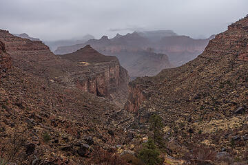 cloudy canyon 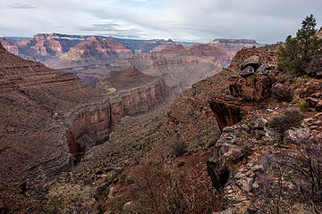 clearing 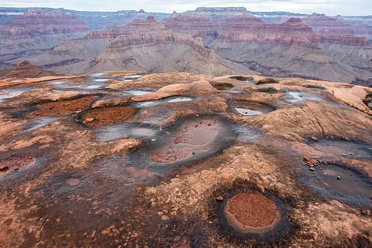 esplanade water pots 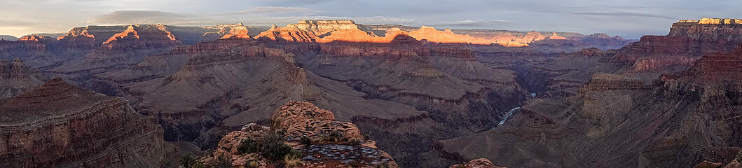 sunset from yuma point camp 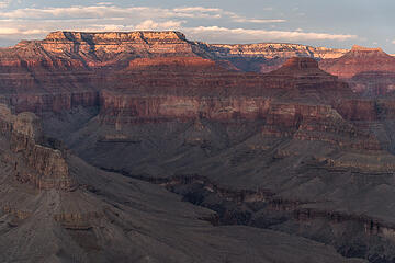 sunset from yuma point camp 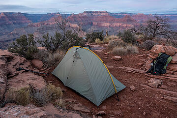 yuma point camp 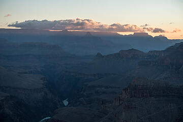 sunrise from yuma point camp 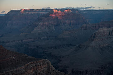 sunrise from yuma point camp 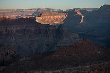 sunrise from yuma point camp 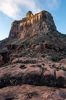 yuma point 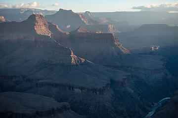 sunrise from yuma point camp 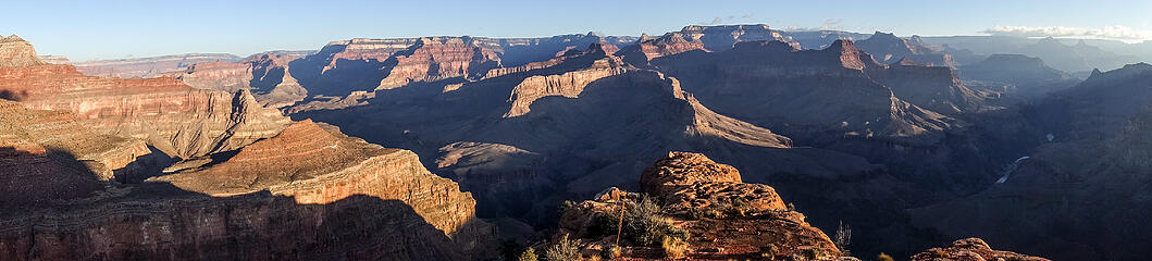 sunrise from yuma point camp 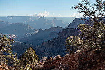 boucher trail 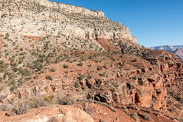 looking back at the boucher trail around eremita mesa 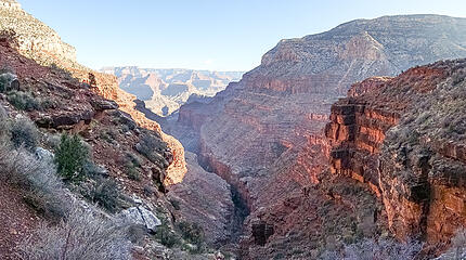 hermit canyon and beyond
|
| Back to top |
  
|
|
JonnyQuest
Member

Joined: 10 Dec 2013
Posts: 593 | TRs | Pics
|
Really nice, RW - I love the many canyon moods you capture in your photos. Brings back memories as well. On a Feb/March river trip this past year (while unbeknownst to us the world was falling apart) we did a layover camp at Hermit and I hiked up the trail to the ruins and old tram site and beyond. Didn't realize the tram was for access to a luxury camp - I assumed it had to do with mining and ore removal. Learn something new on this site everyday!
|
| Back to top |
|
|
jstern
Member

Joined: 04 Apr 2010
Posts: 29 | TRs | Pics
Location: Auburn |
|
jstern
Member
|
 Tue Feb 02, 2021 4:33 pm |
|
|
What a great trip, and you have captured some awesome images, thank you for sharing. Have not done that part of the GC, and makes me want to add to my backlog! 
"Adventure is just bad planning." - Roald Amundsen
"Adventure is just bad planning." - Roald Amundsen
|
| Back to top |
|
|
Eric Hansen
Member
Joined: 23 Mar 2015
Posts: 866 | TRs | Pics
Location: Wisconsin |
Great photos. Thanks! Winter in the canyon is great. 45 trips there and I haven't slept at Yuma Pt. I'm typically there in February and the Dripping Springs Trail is icy and exposed then. Time on the Tonto is rarely a loss. Sitting on the lip of the Inner Gorge, looking along the river is mesmerizing.
|
| Back to top |
|
|
neek
Member

Joined: 12 Sep 2011
Posts: 2336 | TRs | Pics
Location: Seattle, WA |
|
neek
Member
|
Wed Feb 03, 2021 8:37 am |
|
|
i may or may not have just spent half a day planning grand canyon trips after reading this report
|
| Back to top |
|
|
Eric Hansen
Member
Joined: 23 Mar 2015
Posts: 866 | TRs | Pics
Location: Wisconsin |
G.C. Permits, timing
Several things worth passing on.
Permit availability is seasonal. Permits for "The Corridor" high demand designated campsites typically limit you to 2 mights per trip. During the "low season", from Nov. 15 to Feb. 28 they expand that to allow you 4 nights. That indicates the strong chances you have of getting the permit you want during that period (i.e. lower demand) whether you are in The Corridor or not.
Many of the springs on the Tonto Plateau that make travel pleasant (without sizable water carries) are seasonal. They begin to flow in November long about the time the Cottonwood leaves drop. Part of that is solar angles and less evaporation but it also reflects less diversion of the flow from the Cottonwood trees. A zip lock baggie makes a viable scoop when a flow is only an inch or two deep.
Sleeping on "the points", at the rim of the Inner Gorge, on the Tonto translates into longer hours of direct sunlight, warmer nights, than sleeping in the side canyon drainages. And sweeping views. Typically, the water load carry to facilitate that is minor.
February is primo. Mid/late November good. Having done 45 winter trips there I don't favor trips right next to the Winter Solstice. Solar angles are low (shadows long) and the night is long as well. Be sure you enjoy the night sky because there is a lot of it.
|
| Back to top |
|
|
rubywrangler
Member
Joined: 04 Aug 2015
Posts: 511 | TRs | Pics
|
Thanks everyone! Hard to take a bad photo of the grand canyon, it is spectacular.
Here's a little info I found about Hermit camp. Looks similar style to High Sierra camps at Yosemite. But with fine dining, apparently.
neek, I am hoping to do the Escalante route late feb or early march if you feel like a southerly road trip...
|
| Back to top |
|
|
Slim
This space for rent

Joined: 31 Aug 2004
Posts: 560 | TRs | Pics
Location: Falling off a turnip truck |
|
Slim
This space for rent
|
Fri Feb 05, 2021 5:07 pm |
|
|
Beautiful photos. Thanks for sharing.
~Slim
"Lean mean money-making-machines serving fiends"
"Lean mean money-making-machines serving fiends"
|
| Back to top |
|
|
Brushbuffalo
Member

Joined: 17 Sep 2015
Posts: 1887 | TRs | Pics
Location: there earlier, here now, somewhere later... Bellingham in between |
Megan, you discovered that the GCNP rangers are very conservative in advising people in hiking plans to the point of being protective in my opinion. For example, when I did the R2R2R in 11 hours I just went, not even checking or reporting it because I feared they wouldnt let me try ( shame on me I suppose). It has become a classic ultrarun these days but it was adventure back in1989.
There are good reasons for the administrative attitude, however. The fascinating book Over the Edge: Death in Grand Canyon is 408 pages of detailing all the ways people have managed to die there#. Too many have been hikers who either underestimated the difficulties, overestimated their ability, or were just plain ignorant or arrogant.
None of which describe you, but they didn't know that. I think they have to have policies to deal with the lowest common denominator.
# I am not sure if the book authors have updated it to cover "death by selfie", although they do cover numerous fatalities involving photopgraphy.
| rubywrangler wrote: | doug, what is this? |
Looks like limestone. But like many such pictures, it is often difficult for me to tell from a single photo.
Passing rocks and trees like they were standing still
Passing rocks and trees like they were standing still
|
| Back to top |
|
|
Brushbuffalo
Member
Joined: 17 Sep 2015
Posts: 1887 | TRs | Pics
Location: there earlier, here now, somewhere later... Bellingham in between |
This is the really fascinating rock! If you were down low in the canyon near the river in the Inner Gorge, the rocks are very old formations of crystalline so- called ' basement' rocks such as the Vishnu schist and the Zoroaster granite. This might be the latter.
(Tip for future: something for scale would be useful, such as a knife, coin, or key.)
Passing rocks and trees like they were standing still
Passing rocks and trees like they were standing still
|
| Back to top |
|
|
rubywrangler
Member
Joined: 04 Aug 2015
Posts: 511 | TRs | Pics
|
Im sure the rangers concern is justified in general - Im just getting tired of arguing my case! Had a similar experience at Guadalupe NP last week.
Both rock photos were taken low in the canyon, in approximately the same location, about a 1/2 mile from the river along hermit creek. I took a few more:
This one was the wall of the canyon:
Difficult to tell, but it is the wall in this photo. Some parts were more or less sparkly.
hermit creek trail
|
| Back to top |
|
|
Brushbuffalo
Member
Joined: 17 Sep 2015
Posts: 1887 | TRs | Pics
Location: there earlier, here now, somewhere later... Bellingham in between |
| rubywrangler wrote: | |
Most likely mica from the pegmatite.
|
Pegmatite ( very coarse- grained granitic rock).
Another tip is to state whether pictures are of bedrock or 'float' (loose material). But since most of us while hiking don't usually carry a rock hammer, I generally assume something held in the hand is float.
Passing rocks and trees like they were standing still
Passing rocks and trees like they were standing still
|
| Back to top |
|
|
rubywrangler
Member
Joined: 04 Aug 2015
Posts: 511 | TRs | Pics
|
|
| Back to top |
|
|
Eric Hansen
Member
Joined: 23 Mar 2015
Posts: 866 | TRs | Pics
Location: Wisconsin |
The cautions from the rangers seem over the top until you hang out with them (not unusual during the winter "slow time") and hear some of the stories -- which are quite incredible.
Some are visitors with mental issues. And a lot of foreigners, perhaps with language issues that impact their assessments. Some highly experienced in other hiking scenarios, but don't realize the canyon doesn't necessarily accept transfer credits. They have a 3 minute conversation with a ranger and misunderstand a comment about the viability of a waterhole. Or the topographic map shows a spring and no one has seen it for 40 years.
I remember visiting with one ranger who had transferred to the canyon from Mt. Rainier. His theory was that at Rainier people look up at the mountain, see the snow and ice, and realize they don't have the background to be up there without a guide. But he thought that at the canyon people stand on the rim, look down, and don't see anything that they perceive as a warning.
|
| Back to top |
|
|
Brushbuffalo
Member
Joined: 17 Sep 2015
Posts: 1887 | TRs | Pics
Location: there earlier, here now, somewhere later... Bellingham in between |
| Eric Hansen wrote: | | at the canyon people stand on the rim, look down, and don't see anything that they perceive as a warning. |
Great point, Eric.
The scale is such that many folks have no idea it is a vertical mile to the river, so they might start down on a 50 degree morning, ( "This is so nice!"), descend a few miles ( "This is so easy! What's the big deal?"), then run out of fluid when the temperature is soaring, become exhausted and hyperthermic......and become an evac or worse.
It's all in the book and the cause for part of the rangers' concern.
Passing rocks and trees like they were standing still
Passing rocks and trees like they were standing still
|
| Back to top |
|
|
|
|
You cannot post new topics in this forum
You cannot reply to topics in this forum
You cannot edit your posts in this forum
You cannot delete your posts in this forum
You cannot vote in polls in this forum
|
Disclosure: As an Amazon Associate NWHikers.net earns from qualifying purchases when you use our link(s). |


