| Previous :: Next Topic |
| Author |
Message |
pula58
Member


Joined: 13 Aug 2009
Posts: 589 | TRs | Pics
|
|
pula58
Member
|
 Sun Feb 07, 2021 3:22 pm |
|
|
Is the trail clear all the way to Pratt Lake (in terms of brush, in summer conditions)?
Are their any decent campsites along the old railroad grade part of the trail? Not necessarily with water, but flat enough for a tent or two?
|
| Back to top |
  
|
|
hunterofelke
Roland
Joined: 04 Aug 2020
Posts: 26 | TRs | Pics
Location: Issaquah |
I've only day hiked that trail so I have only gone maybe a quarter of the railroad grade. If you are looking for a campsite and you are still on the grade, just plop down there. Probably the flattest spot around. The trail reports I've read say the crossing of Pratt River is the brushiest. I know the horse crew worked the trail last summer and a work crew from the lake was on the trail.
|
| Back to top |
|
|
thuja
Member
Joined: 13 Sep 2018
Posts: 67 | TRs | Pics
|
|
thuja
Member
|
Sun Feb 07, 2021 6:56 pm |
|
|
I did this trail just after Christmas and there were multiple creek crossings that were raging torrents we had to wade through. In several places the trail was a stream. Started from the Middle Fork. There was one campsite area about a mile or two down the trail, near the Mid Fork, but it was covered in big pools of water.
|
| Back to top |
|
|
FredV
Member
Joined: 09 Mar 2007
Posts: 132 | TRs | Pics
Location: Kent,WA |
|
FredV
Member
|
Mon Feb 08, 2021 8:16 am |
|
|
The comments in this WTA trip report mentions campsites
WTA Trip Report
"some new campsites around mile 5.5 up near the first waterfall on the upper trail."
|
| Back to top |
|
|
puzzlr
Mid Fork Rocks

Joined: 13 Feb 2007
Posts: 7220 | TRs | Pics
Location: Stuck in the middle |
|
puzzlr
Mid Fork Rocks
|
Wed Feb 10, 2021 12:28 am |
|
|
Once you reach the wide old RR grade there should be multiple places to camp. I haven't ever been up in the winter. Thanks to thuja for the warning about creek crossings -- I can imagine which ones those are. But they won't be nearly as bad as crossing the Pratt itself if that's your plan.
|
| Back to top |
|
|
JimK
Member

Joined: 07 Feb 2002
Posts: 5606 | TRs | Pics
Location: Ballard |
|
JimK
Member
|
Wed Feb 10, 2021 12:36 pm |
|
|
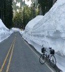
I concur with puzzlr. Lots of flat spots along the old grade. Both Kaleetan Creek and the Pratt River would be difficult to cross when the water is deep and fast. Here is a photo from the railroad grade.
 Pratt River Trail
|
| Back to top |
|
|
philfort
Member
Joined: 02 Sep 2003
Posts: 444 | TRs | Pics
Location: seattle |
|
philfort
Member
|
Wed Feb 10, 2021 12:55 pm |
|
|
Wow, how did they get a railroad up there? Did there used to be a bridge across the Middle Fork, or did it come up the south side of the river from North Bend?
|
| Back to top |
|
|
FiveNines
Member
Joined: 01 Oct 2010
Posts: 526 | TRs | Pics
|
North Bend Timber Co built a bridge across MFK in 1936?
http://hikingwithmybrother.blogspot.com/2014/10/shortcut-to-pratt-river-trail-1035.html
| hike w/my bro wrote: | | In 1934 the North Bend Timber Company acquired the rights to log the Pratt River Valley and quickly began constructing a logging railroad largely following the Pratt River Trail route. A bridge across the Middle Fork was completed in 1936 and the railroad stretched the length of the valley by 1937. Over the next several years, the valley walls were logged up to 300 feet on either side of the tracks, which was the furthest reach of the cables. By 1941 the easy timber had been harvested and the North Bend Timber Company began pulling out the rails, leaving the wooden ties behind. Aside from some intermittent truck logging in the 1950s, this was the end of the major logging operations along the Pratt. |
|
| Back to top |
|
|
Mike Collins
Member
Joined: 18 Dec 2001
Posts: 3097 | TRs | Pics
|
|
| Back to top |
|
|
puzzlr
Mid Fork Rocks
Joined: 13 Feb 2007
Posts: 7220 | TRs | Pics
Location: Stuck in the middle |
|
puzzlr
Mid Fork Rocks
|
Wed Feb 10, 2021 3:22 pm |
|
|
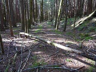
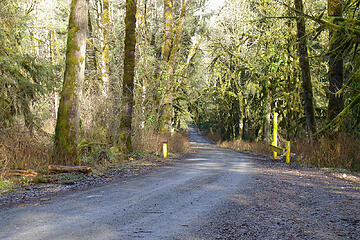
This yellow gate at ~MP 7.8 was installed just before Big Blowout creek in 2009 to close the road for months while repairs from the big flood in that year were done. The gate is long gone now, but this is where the Pratt RR split off from the main line to cross the Middle Fork. If you walk off the road you can still see the built-up berm, although it was obscured somewhat when the road was paved.
The remains of the trestle bridge still poke up out of the river bed at low water
 Trestle remains  Pratt RR grade
|
| Back to top |
|
|
Kim Brown
Member
Joined: 13 Jul 2009
Posts: 6899 | TRs | Pics
|
| philfort wrote: | | Wow, how did they get a railroad up there? |
Jim, Gwen and I did a key exchange with Puzzlr several years ago; Puzzlr started at the MidFk ford, and we started at the Ollalie trail head. We picked up the rail road grade not too far below the Pratt Lake outlet. That's how far in it went.
From the outlet is a nice old trail with puncheon that switcbacks down to the Pratt ford.
The entire length of the grade is a wonderful haven for ground hornets, so watch where you pitch camp.
Puzzlr and Jim have much better statistical detail; I just sorta go and do stuff.
"..living on the east side of the Sierra world be ideal - except for harsher winters and the chance of apocalyptic fires burning the whole area."
Bosterson, NWHiker's marketing expert
"..living on the east side of the Sierra world be ideal - except for harsher winters and the chance of apocalyptic fires burning the whole area."
Bosterson, NWHiker's marketing expert
|
| Back to top |
|
|
philfort
Member
Joined: 02 Sep 2003
Posts: 444 | TRs | Pics
Location: seattle |
|
philfort
Member
|
Thu Feb 11, 2021 2:02 pm |
|
|
Thanks for all the historical context!
I've spent quite a bit of time in the Middle Fork area last fall (after not having been back there after they paved it), and have gradually become interested in the history of the area as I've discovered various weird things back there ;-).
Also interested in the future of the area after coming across a trail that isn't on any maps, and yet was cleared and had colored trail markers on it (didn't have time to follow it for more than a mile though). Does anyone know where I can find out info on what future plans are for the middle fork? It changed so much after they paved it. There was some website (can't seem to find it now) that had a bunch of info and blog posts, but it stopped being updated after the Garfield Ledges trail was opened several years ago. Seems like there's a lot of opportunity for that area to absorb backcountry users if there were more trails.
|
| Back to top |
|
|
zephyr
aka friendly hiker

Joined: 21 Jun 2009
Posts: 3370 | TRs | Pics
Location: West Seattle |
|
zephyr
aka friendly hiker
|
Thu Feb 11, 2021 2:54 pm |
|
|
| philfort wrote: | | There was some website (can't seem to find it now) that had a bunch of info and blog posts, |
Are you referring to Mid Fork Rocks? That's puzzlr's wonderful resource. ~z
|
| Back to top |
|
|
philfort
Member
Joined: 02 Sep 2003
Posts: 444 | TRs | Pics
Location: seattle |
|
philfort
Member
|
Thu Feb 11, 2021 3:17 pm |
|
|
|
| Back to top |
|
|
puzzlr
Mid Fork Rocks
Joined: 13 Feb 2007
Posts: 7220 | TRs | Pics
Location: Stuck in the middle |
|
puzzlr
Mid Fork Rocks
|
Thu Feb 11, 2021 10:08 pm |
|
|
That's my site. I'm ok writing trip reports but a failure as a website author. I don't update the site much but still have hopes that someday I will. There's so much to say and show!
|
| Back to top |
|
|
|
|


 www.nwhikers.net/forums/viewtopic.php?t=8033437' border="0" />

