| Previous :: Next Topic |
| Author |
Message |
JonnyQuest
Member


Joined: 10 Dec 2013
Posts: 593 | TRs | Pics
|
There also used to be a (blog?) site on stands of old growth found up the MFS. Can't find the link, don't remember the name, and not sure it still exists...
|
| Back to top |
  
|
|
ChanceShowers
Member

Joined: 06 Sep 2018
Posts: 49 | TRs | Pics
Location: Seattle |
|
| Back to top |
|
|
philfort
Member
Joined: 02 Sep 2003
Posts: 442 | TRs | Pics
Location: seattle |
|
philfort
Member
|
 Fri Feb 12, 2021 1:35 pm |
|
|
Interesting... so it looks like the Middle Fork road beyond the Taylor River junction didn't follow the old railroad line (since traces of it are visible in the woods a few hundred feet above the road today - at least in some areas).
|
| Back to top |
|
|
puzzlr
Mid Fork Rocks

Joined: 13 Feb 2007
Posts: 7220 | TRs | Pics
Location: Stuck in the middle |
|
puzzlr
Mid Fork Rocks
|
Fri Feb 12, 2021 11:43 pm |
|
|
The railroad came first, then the road mostly followed the RR line when the railroad tracks were pulled out in the late 40s. Here's the best map of the railroads at about their most extensive. The Pratt logging railroad was put in after this. The Taylor was mostly truck logged after the railroad was gone.
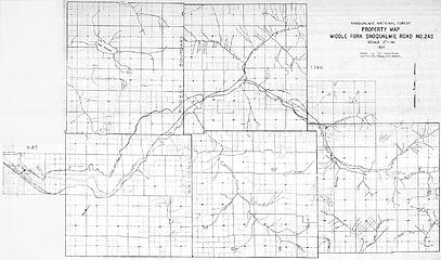 1937 Middle Fork map
|
| Back to top |
|
|
crock
Member
Joined: 14 Aug 2004
Posts: 103 | TRs | Pics
Location: Newcastle |
|
crock
Member
|
Sat Feb 13, 2021 6:04 pm |
|
|
| puzzlr wrote: | | If you know what to look for, there are lots of interesting details in this map. Check out the Dingford Creek crossing (road different than railroad?) and at Granite Creek the railroad swerves upstream before crossing, unlike the straight through Middle Fork road today. |
It is an interesting map, but I wouldn't put to much faith in details like a bend in the railroad by Granite Creek: it's not the most accurate map. For example, the map shows Granite Creek going through the section corner of sections 10, 11, 15, and 16, when in fact Granite Creed is at least 1/3 of a mile from that section corner. Mapping has gotten more accurate over the decades, but even the 1913 USGS 1:125,000 map correctly showed Granite Creek's placement.
Something interesting on that 1913 USGS map is where the road crossed the Middle Fork Snoqualmie River by Tanner.
|
| Back to top |
|
|
puzzlr
Mid Fork Rocks
Joined: 13 Feb 2007
Posts: 7220 | TRs | Pics
Location: Stuck in the middle |
|
puzzlr
Mid Fork Rocks
|
Sat Feb 13, 2021 9:31 pm |
|
|
OP: Sorry we're getting off topic here.
Yeah, I know about the vagaries of old maps. But that's what makes them interesting! It's what someone thought how things were at the time.
Re the swerve in the road at Granite Creek. I agree that it misplaced Granite Creek. But that was the route of the logging RR based on other more detailed maps. The current "Big River Bridge" or "Concrete Bridge" was not built until the early 1960s. The old RR grade heading to that old alignment upstream is still (barely) evident as linear sparse tree growth on the up valley side of the bridge. I have not been able to find any trestle foundations even at low water, but have talked people who remember the trestle bridge upstream of of the Big River Bridge when they were young. No big deal, but this map is another confirmation of it, and the RR followed part of the route of the old Middle Fork trail shown on the 1913 map.
The 1913 map is also really interesting. What map isn't? Note the part of the old Horseshoe Mine trail coming down the ridge to near the confluence. That is right along the route of the recently built Granite Creek connector trail. I uploaded the section in question for everyone that doesn't have access to this map. Look at the landscape -- pretty bleak in the early 1900s.
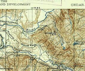 1913 map 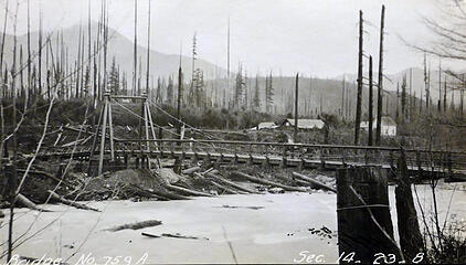 1908 Tanner Bridge 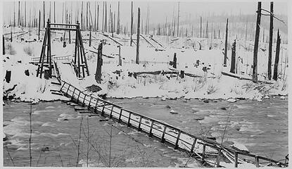 1913 Tanner Bridge
|
| Back to top |
|
|
crock
Member
Joined: 14 Aug 2004
Posts: 103 | TRs | Pics
Location: Newcastle |
|
crock
Member
|
Sun Feb 14, 2021 5:19 pm |
|
|
| puzzlr wrote: | | The old RR grade heading to that old alignment upstream is still (barely) evident as linear sparse tree growth on the up valley side of the bridge. |
I see that linear feature in the Google 7/23/2018 aerial photo. Curiously, the Middle Fork road prior to building the "Concrete Bridge" seems to have crossed the Middle Fork at the same location as the logging railroad trestle, but on the north side of the river it didn't follow the RR grade that can still be seen as the linear feature in the 7/23/2018 aerial photo. According to the USGS 1960 1:62,500 Bandera quadrangle, the road seems to have gone north from the bridge (not slightly east of north like the RR grade), and the road line is apparent in some older aerial photos (the angle of the sun makes a difference in seeing these cuts).
About 2.5 miles north of the concrete bridge and just north of the old logging road going up the south side of Mt Bessemer, the Middle Fork Road has some tight turns next to the creek descending from Bessemer. In the creek there are old pilings. Are those pilings part of the old logging railroad tracks?
Those are interesting photos of the old Middle Fork bridge by Tanner. It doesn't look like much, but it was probably built for horse and wagon and, judging from the 1913 map, didn't serve many people.
Puzzlr - you can obviously read a map, ever try orienteering?
|
| Back to top |
|
|
wolffie
Member

Joined: 14 Jul 2008
Posts: 2693 | TRs | Pics
Location: Seattle |
|
wolffie
Member
|
Mon Feb 15, 2021 11:43 pm |
|
|
I like that trail. I've been clearing blowdown on it since it was built (I helped).
When the road's open, it can be a good dumpster-dive choice in winter when the weather up high is awful, or avvy danger is high, and you just want to get the hell out of the city and don't want to drive far. I'd advise being the first to leave the trailhead, and the last to return; the first coupla miles can be a zoo.
I want to do the loop over Milakwa Pass to Snow Lake and out the Middle Fork (which I believe is still closed and likely has a lot of blowdown).
I'm still confused about the railroad. I don't understand where the proximal end was. The trail leaves the Middle Fork, ascends considerably (the only place close to steep on the trail; the rough place), and then <Presto>, you're on the railroad grade. That part is up rather high, so I don't think it was the proximal end. It just seems to end there
I seem to remember an old map in the Suzzallo Map Library that showed the RR hairpinning across the Pratt and running down the west bank??
Suzzallo is a great place; they have old maps with all kinds of old roads and trails that have been dropped from recent maps.
My Green Trails Mt Si gives a compass declination of 22 degrees, and has an arrow pointing to I-5 near North Bend, saying "under construction".
Some people have better things to do with their lives than walking the dog. Some don't.
Some people have better things to do with their lives than walking the dog. Some don't.
|
| Back to top |
|
|
mosey
Member

Joined: 18 Dec 2018
Posts: 163 | TRs | Pics
|
|
mosey
Member
|
Wed Feb 17, 2021 2:33 pm |
|
|
| wolffie wrote: | | That part is up rather high, so I don't think it was the proximal end. It just seems to end there
I seem to remember an old map in the Suzzallo Map Library that showed the RR hairpinning across the Pratt and running down the west bank?? |
Unfortunately the west bank bit is completely overgrown.
http://mvkazit.blogspot.com/2016/06/revolution-peak-russian-butte-pratt.html
| Quote: | | Last note - if a route is on the map, it doesn't mean anything.... "1925 Railroad grade" - exists, but was absolutely useless... (edited)
|
|
| Back to top |
|
|
Backpacker Joe
Blind Hiker

Joined: 16 Dec 2001
Posts: 23956 | TRs | Pics
Location: Cle Elum |
Back in the early Nineties you could drive and park on the river bank next tot the start of the Pratt Valley trail. I waded across the MF and climbed the bank. I got a late start so that night I slept on the railroad bed and the next day I hiked up to Lower Tuscohatchie lake. I didnt know then that the trail actually made its way up to Pratt lake. I hiked back the next day. It was a nice, though at times boring hike. 
"If destruction be our lot we must ourselves be its author and finisher. As a nation of freemen we must live through all time or die by suicide."
Abraham Lincoln
"If destruction be our lot we must ourselves be its author and finisher. As a nation of freemen we must live through all time or die by suicide."
Abraham Lincoln
|
| Back to top |
|
|
|
|


