| Previous :: Next Topic |
| Author |
Message |
crock
Member


Joined: 14 Aug 2004
Posts: 103 | TRs | Pics
Location: Newcastle |
|
crock
Member
|
 Fri Jan 22, 2021 7:14 pm |
|
|
|
| Back to top |
  
|
|
hunterofelke
Roland
Joined: 04 Aug 2020
Posts: 26 | TRs | Pics
Location: Issaquah |
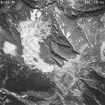
Today,(1/23/21) I hiked down to the Rainy Mine site. They really did a good job destroying the old road, but it was passable through a lot of salmon berry bushes and devils club. The main shaft site is just a hillside of rocks, but some old saw cut timbers, metal rods, and near the creek I found some parts from maybe a compressor or winch. Down by the creek just below the mine site there is a big dead hemlock with three wraps or cable around it. Pretty certain that killed the tree. Another thing that was interesting was a one inch cable going across Quartz creek and to another dead tree with cable wraps around it. I was surprised the cable was still unbroken. I wonder what this was for? My guess an anchor for the ore tram going up hill to the main road.
|
| Back to top |
|
|
puzzlr
Mid Fork Rocks

Joined: 13 Feb 2007
Posts: 7220 | TRs | Pics
Location: Stuck in the middle |
|
puzzlr
Mid Fork Rocks
|
Sun Jan 24, 2021 12:33 am |
|
|
| crock wrote: | | Puzzlr - where did you get this picture? I like old aerial photos. |
Scanned it at the National Archives at Sand Point. Forest Service collection. They're still closed because of COVID, and may be leaving Seattle permanently unless sane people keep the NW history in the NW.
|
| Back to top |
|
|
crock
Member
Joined: 14 Aug 2004
Posts: 103 | TRs | Pics
Location: Newcastle |
|
crock
Member
|
Mon Jan 25, 2021 10:44 am |
|
|
| puzzlr wrote: | | crock wrote: | | Puzzlr - where did you get this picture? I like old aerial photos. |
Scanned it at the National Archives at Sand Point. Forest Service collection. They're still closed because of COVID, and may be leaving Seattle permanently unless sane people keep the NW history in the NW. |
Individuals can come into the Sand Point building (when it is open) and scan aerial photos, but these aerial photos aren't online?
|
| Back to top |
|
|
puzzlr
Mid Fork Rocks
Joined: 13 Feb 2007
Posts: 7220 | TRs | Pics
Location: Stuck in the middle |
|
puzzlr
Mid Fork Rocks
|
Mon Jan 25, 2021 5:41 pm |
|
|
No, most of the collection is not online -- they have massive amounts of materials and digitization has a long ways to go. Even the indices to the various series are not that detailed. There are many boxes of USFS aerial photos. In the boxes there are maps that identify where each photo was taken (this was how the USFS organized them) but even those maps are not online. I scanned and stitched these too. I uploaded one of them to give you an idea of what they look like. After one gets used to the system you don't waste as much time and get more scanning done.
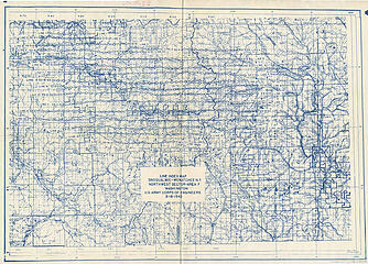 1942 USFS aerial photo line index
|
| Back to top |
|
|
timberghost
Member
Joined: 06 Dec 2011
Posts: 1332 | TRs | Pics
|
So how were you able to obtain this map? Time on their hands and not out in the field guess what time to digitize 
|
| Back to top |
|
|
fjoro
Member

Joined: 27 Jun 2006
Posts: 196 | TRs | Pics
|
|
fjoro
Member
|
Fri Feb 12, 2021 1:44 pm |
|
|
| puzzlr wrote: | | Scanned it at the National Archives at Sand Point. Forest Service collection. They're still closed because of COVID, and may be leaving Seattle permanently unless sane people keep the NW history in the NW. |
Judge blocks sale and closure of National Archives in Seattle
How would Horatio Alger have handled this situation?
How would Horatio Alger have handled this situation?
|
| Back to top |
|
|
timberghost
Member
Joined: 06 Dec 2011
Posts: 1332 | TRs | Pics
|
It would be a shame to see this building sold and the documents moved out of state.
|
| Back to top |
|
|
puzzlr
Mid Fork Rocks
Joined: 13 Feb 2007
Posts: 7220 | TRs | Pics
Location: Stuck in the middle |
|
puzzlr
Mid Fork Rocks
|
Wed Feb 17, 2021 7:40 pm |
|
|
And even worse, for the past year when it could have been available for people to finish up research on an accelerated schedule the facility has been closed because of COVID restrictions. I was actually there on March 25, 2020 doing scanning the last day it was open to the public. They told everyone they could stay until closing time. I crammed in as much as I could get.
|
| Back to top |
|
|
|
|


 www.nwhikers.net/forums/viewtopic.php?p=1203861#1203861' border="0" />