| Previous :: Next Topic |
| Author |
Message |
Mark Hadland
#thehad


Joined: 30 Jun 2018
Posts: 50 | TRs | Pics
Location: Seattle |
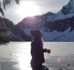
Epic winter ascent of Moolock Mountain, my 15th Home Court 100. Benson and I gained 5200 feet, 15.5 miles, in 11 hours C2C. Normally a tame jaunt up an old logging road, today's winter conditions presented a great snowshoe hike from 2500 - 4000 feet. After 4000 feet, the road becomes a trail, taking one through a winter wonderland of snow swept corridors, deep snow gated by towering trees, branches, and boughs heavy with a fresh dump of winter snow, which became increasing deep from a fresh dump this week, deepening the track to at least 24 inches. Travel became increasingly slow from 4000 feet to the summit which measured just shy of 5000. It felt like we were traversing in quicksand (like I would know what that's like).
Per the mountain forecast, winds increased in the afternoon to 25+ mph blowing snow sidewise into our faces. It was snowing forcefully - not large flakes, but lots of small particles, sting any exposed body part. All of my gear froze up - straps, buckles, zippers - all became marginally functioning and made gear swap out cold and cumbersome. I went through 3 pairs of gloves. My hair even froze stiff! Visibility increasingly dropped to about 100 feet on the final push. The trail veered off to the left of the ridge, which put us under a 35-45 degree slope that looped ripe for a slide. We backtracked and made a direct line for the summit ridge. This proved challenging as the fresh snow was powdery and loose. Attempts to gain purchase with our snowshoes left us sloughing off 24" of fresh snow with each step until we could find the hardpack and dig in the teeth and crampons of the snowshoes. Kick stepping proved futile in these conditions, and our axes only sank to the head. We finally obtained the ridge which provided a brief respite of the sloppy and slippery ascent and pushed upward. The right side of the ridge was heavily corniced and had a steep dropoff. We continued upwards which only got steeper and made for some interesting moves. We finally obtained the summit, which appeared corniced from our approach, so we gingerly got close, but stayed below the expected ridge crest for safety, as any incident up here in these conditions would have been a bad situation with the weather. We descended after a couple of minutes, opting not to eat as the weather was worsening and the trip back down the ridge would prove challenging. The wind was blowing so hard, that within 10 minutes of the summit, our tracks were completely covered. Fortunately, we reconnoitered the ridge with sufficient attention to know the path down, plus had a Suunt0, 3 Garmins, Gais, AllTrails, map, MC Global, blah blah blah - we could find the way down. We plunged stepped, glissaded and slid down the initial 500 feet, then donned our snowshoes for the remainder for the descent. Shortly thereafter I began to posthole up to my waist only to realize that I lost a snowshoe about 200 feet up - and up I went searching for it. Fortunately, I found it, otherwise, it was going to be a long 4000 feet and 7 miles down.
We considered bagging South Bessemer, but darkness was settling in, we were cold, and a Popeyes Chicken Sandwich at exit 34 was awaiting - and we did not know when they closed, so that influenced our turn around time and motivated us to pick up the pace down. For future reference, Popeyes is open until 9PM. All in all, a superb outing, testing our limits, capabilities, gear, and judgment.
On the descent down the logging road portion, we post mortemed our trip up, thinking about the choice to push on. We felt the avy danger was reduced by taking the ridge, we were adequately skilled, prepared to spend an unplanned evening if necessary, had the means for a rescue worse case, but being Mountaineers prefer to be self-reliant, and overall felt physically and mentally well after the uphill push. For my fellow PNW Peakbaggers, I know you all have the skills and knowledge to see if this trip in this condition is for you. In retrospect, I would choose a good weather day - little to no precip, minimal wind, and solid snow conditions would make for a better outing - we had no views which disappointing as we were looking forward to seeing Lake Moolock, Lake Nadeaum, and SMC Lake. Perhaps a future trip up South Bessemer is in order.
|
| Back to top |
  
|
|
KascadeFlat
Member
Joined: 06 Jul 2020
Posts: 314 | TRs | Pics
Location: Eating peanut M&Ms under my blue tarp |
I can feel this trip report in my hip flexors...  Way to get after it!
For a good time call: 1-800-SLD-ALDR.
For a good time call: 1-800-SLD-ALDR.
|
| Back to top |
|
|
Legionnaire
Member

Joined: 11 Dec 2020
Posts: 7 | TRs | Pics
Location: Seattle |
Sounds EPIC! You should update this with your photos from the lazy trip reports section, they make it look even more brutal. My buddy and I want to do more snow stuff a lot like this, but are learning as much as we can slowly here. Just bought an axe the other day after going up Granite Mountain and turning back way before anything got too sketchy, it was fun, but I want to be more prepared in the future.
When you go on a hike like this do you have any tips? Things to look out for weather-wise other than checking NWAC? What kind of snowshoes do you have for this steep terrain? Are you carrying basically everything you need in case you were to have to spend a night? Thanks for all your info, looks like fun!
PS: The photos just loaded for me!!
|
| Back to top |
|
|
Mark Hadland
#thehad
Joined: 30 Jun 2018
Posts: 50 | TRs | Pics
Location: Seattle |
Thanks, I just figured how to add the photos, so will be able to include them in future TR's.
We are both Mountaineers and one of us AIARE trained. Ice axe always a requirement, and poles for me on every outing. When I get tired, I get clumsy and have saved hundreds of falls with my poles. The one time I stashed my poles on a simple Lake Annette hike, I tripped and cracked my hand breaking a very small fall. In general, I will default to wearing a boot with automatic crampon support and pack 12 points for snowy terrain - maybe overkill, but unless I know the conditions require less, I go with these, vs additional aggressive microspikes. I use MSR Lightning Ascents 25". I am 6'2, 220, I see some folks with shorter ones. For this trip, we could have used the detachable tails for more float, but considering shorted ones for more packed snow. In general, I carry the 10 essentials and have gear for an unplanned bivy (extra food, water filter - even in winter as I sweat a lot and go through a lot of water, extra clothing, bivy bag, Garmin InReach in addition to Fenix 6x, Gaia, AllTrails, CalTopo printed on water proof paper, etc...). In winter I am now carrying 4 sets of gloves of various weights and waterproofness - I am getting colder as I get older.
Re Granite, I am sure you know the navy danger at the chutes - I am considering the route up Pratt Lake TH via Tusk O' Granite which appears to have a lower slope angle.
We check NWAC, and mountain-forecast.com (my goto for summit conditions).
|
| Back to top |
|
|
Mark Hadland
#thehad
Joined: 30 Jun 2018
Posts: 50 | TRs | Pics
Location: Seattle |
I have a Campbell Forest key coming, so plan to hit some of the North Fork Home Court 100's from the West and plan to check out the lakes later in the season when I can drive closer and maybe do some fishing. The Popeye's chicken sandwich was a great motivator to get moving faster down once we were off the snow!
|
| Back to top |
|
|
RichP
Member

Joined: 13 Jul 2006
Posts: 5633 | TRs | Pics
Location: here |
|
RichP
Member
|
 Thu Mar 25, 2021 3:47 pm |
|
|
Strong work and great first report. I'll have to try one of those Popeye's sandwiches; it sounds like it works better than spinach. 
|
| Back to top |
|
|
puzzlr
Mid Fork Rocks

Joined: 13 Feb 2007
Posts: 7220 | TRs | Pics
Location: Stuck in the middle |
|
puzzlr
Mid Fork Rocks
|
Fri Mar 26, 2021 10:20 pm |
|
|
Congrats on that summit in these conditions. It's harder to get to than it seems on a map. I had two failed attempts before finally making it to the top from the Middle Fork road. One year I had a Hancock/Cambell permit and strolled up to the ridge from the end of the logging road by Lake Nadeau -- my only semi-easy trip to the top on this peak.
|
| Back to top |
|
|
|
|
You cannot post new topics in this forum
You cannot reply to topics in this forum
You cannot edit your posts in this forum
You cannot delete your posts in this forum
You cannot vote in polls in this forum
|
Disclosure: As an Amazon Associate NWHikers.net earns from qualifying purchases when you use our link(s). |


