| Previous :: Next Topic |
| Author |
Message |
RichP
Member


Joined: 13 Jul 2006
Posts: 5634 | TRs | Pics
Location: here |
|
RichP
Member
|
 Wed Mar 17, 2021 8:50 pm |
|
|
This is an 8ish mile hike each way from the confluence of the Palouse and Snake Rivers at Lyons Ferry upstream to Palouse Falls. The Ice Age Flood Institute offers this as a guided outing once a year but hasn't in recent times likely due to the pandemic. I decided to give it a try myself.
I parked at the Lyons Ferry Game Management Unit (Lyons Ferry SP proper still closed for winter) and started walking up the road until an old two track appeared below me. This will eventually connect to a trail that leads to Marmes Pond.
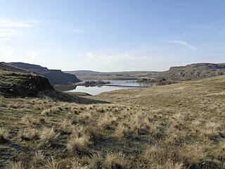 Confluence of The Palouse and Snake Rivers. 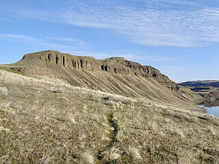 A pretty good use trail goes from Lyons Ferry to Marmes Pond. 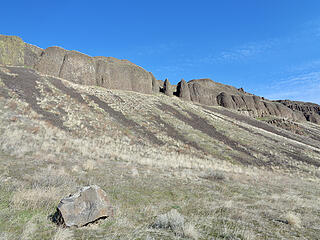 Basalt on Peak 362. 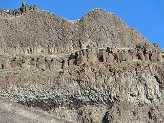 Layers. 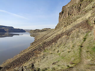 Looking back to the mouth of The Palouse River. 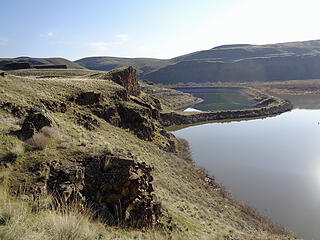 The submerged Marmes Rock Shelter and its failed attempt to wall off the rising water after dams were built downstream on The Snake. 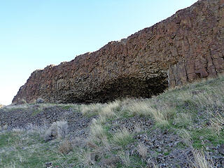 A rock shelter above Marmes. 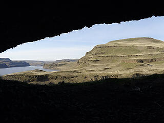 Looking out. 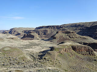 Palouse Buttes. 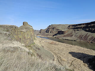 Staying high. I occasionally had to scramble to higher ground when getting cliffed out. 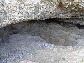 This rock shelter is enormous and is about 15' high inside and goes back 40.' 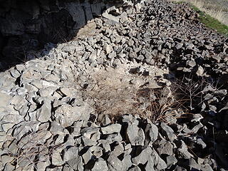 Circular stone structures inside. 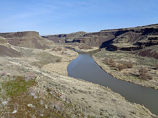 An island ahead. 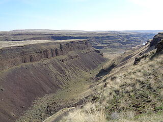 Side canyons began to appear and forced me away from the river. 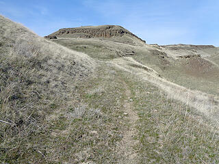 The final 1.6 miles is on an old road. 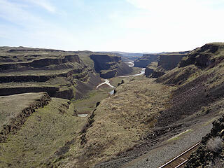 Nearing Palouse Falls. 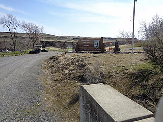 Bridge over the railroad and park entrance. 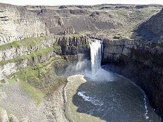 After about 8 miles I reach my destination. 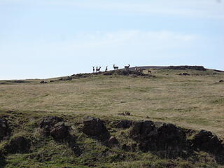 Hiking back to Lyons Ferry. 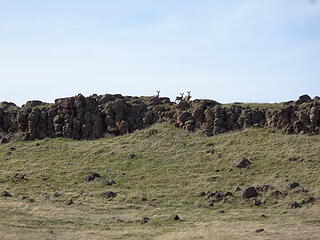 Lots of onlookers. 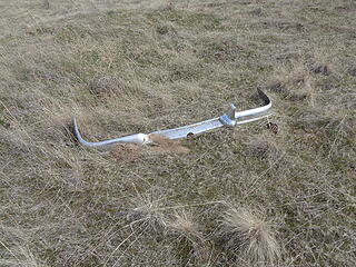 Random. 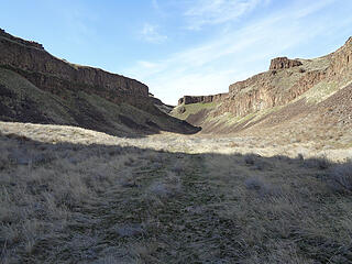 I took a shortcut down this canyon back to Marmes Rock Shelter. 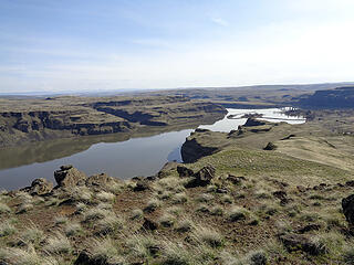 Nearing Lyons Ferry. 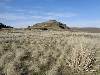 I walked over Peak 362. 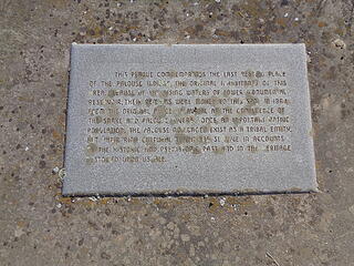 Old Bones Cemetery. 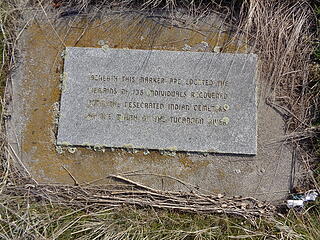 Old Bones Cemetery. 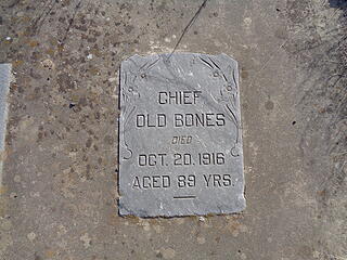 Old Bones Cemetery.
|
| Back to top |
  
|
|
fourteen410
Member

Joined: 23 May 2008
Posts: 2629 | TRs | Pics
|
I have this same trip planned for the spring. Your pics make me excited to go 🙂
|
| Back to top |
|
|
neek
Member

Joined: 12 Sep 2011
Posts: 2338 | TRs | Pics
Location: Seattle, WA |
|
neek
Member
|
Thu Mar 18, 2021 6:23 am |
|
|
This looks great! Ticks out yet?
|
| Back to top |
|
|
RichP
Member
Joined: 13 Jul 2006
Posts: 5634 | TRs | Pics
Location: here |
|
RichP
Member
|
Thu Mar 18, 2021 7:38 am |
|
|
| neek wrote: | | Ticks out yet? |
Haven't found any yet.
| fourteen410 wrote: | | I have this same trip planned for the spring. Your pics make me excited to go 🙂 |
Should be some flowers out to make it even more scenic.
|
| Back to top |
|
|
Pyrites
Member

Joined: 16 Sep 2014
Posts: 1884 | TRs | Pics
Location: South Sound |
|
Pyrites
Member
|
Thu Mar 18, 2021 10:56 am |
|
|
Apparently this route exists clear to outskirts of Cheney.
Did it look as if it could be ridden on a mountain bike?
Keep Calm and Carry On?
Heck No.
Stay Excited and Get Outside!
Keep Calm and Carry On?
Heck No.
Stay Excited and Get Outside!
|
| Back to top |
|
|
RichP
Member
Joined: 13 Jul 2006
Posts: 5634 | TRs | Pics
Location: here |
|
RichP
Member
|
Thu Mar 18, 2021 11:01 am |
|
|
| Pyrites wrote: | | Did it look as if it could be ridden on a mountain bike? |
You could take the service road toward Marmes Pond and break off toward the railroad tracks to get on the dirt road to Palouse Falls. You wouldn't get to see the neat scenery along the river but it's totally bikeable with the exception of having to push it through a couple areas where rocks have fallen. I thought about the possibility during my hike.
Continuing to Cheney would be a challenge if you are referring to the Columbia Plateau Trail. Much of it is fist-sized rocks on the old rail bed which ain't too bike friendly. I tried hiking on it in Washtucna Coulee and it is difficult. If they can ever get some smaller gravel on top of this it will be a spectacular ride/hike/horsie route. It's already been established as a state park but save for a few sections on the northern end, it's not really usable.
|
| Back to top |
|
|
Pyrites
Member
Joined: 16 Sep 2014
Posts: 1884 | TRs | Pics
Location: South Sound |
|
Pyrites
Member
|
Thu Mar 18, 2021 8:16 pm |
|
|
Thanks.
Keep Calm and Carry On?
Heck No.
Stay Excited and Get Outside!
Keep Calm and Carry On?
Heck No.
Stay Excited and Get Outside!
|
| Back to top |
|
|
Slugman
Its a Slugfest!

Joined: 27 Mar 2003
Posts: 16874 | TRs | Pics
|
|
Slugman
Its a Slugfest!
|
Fri Mar 19, 2021 1:10 pm |
|
|
Looks like a good canoe trip.
|
| Back to top |
|
|
kite
Member

Joined: 28 Sep 2009
Posts: 1416 | TRs | Pics
Location: Olympia |
|
kite
Member
|
Fri Mar 19, 2021 3:03 pm |
|
|
| Slugman wrote: | | Looks like a good canoe trip. |
might want to skip the fall's I think they are still looking for the kayaker that went over a few years ago.
|
| Back to top |
|
|
Slugman
Its a Slugfest!

Joined: 27 Mar 2003
Posts: 16874 | TRs | Pics
|
|
Slugman
Its a Slugfest!
|
Fri Mar 19, 2021 6:28 pm |
|
|
He started at the Snake and hiked upriver to the falls.
|
| Back to top |
|
|
puzzlr
Mid Fork Rocks

Joined: 13 Feb 2007
Posts: 7220 | TRs | Pics
Location: Stuck in the middle |
|
puzzlr
Mid Fork Rocks
|
Sat Mar 20, 2021 12:41 am |
|
|
Fantastic report. This really makes me want to go do some section of this hike. The water impounded burial grounds is a sad story, but at least something was done.
|
| Back to top |
|
|
Downhill
Member
Joined: 30 Jul 2018
Posts: 342 | TRs | Pics
Location: Leavenworth |
|
Downhill
Member
|
Tue Mar 23, 2021 9:17 pm |
|
|
Excellent TR - thank you for the post and photos!
For those who are so inclined, there is excellent fishing in the Snake, Palouse, and the Marmes pond. Just upriver from the Palouse-Snake confluence is the confluence of the Snake and the Tocannon rivers. The Tocannon has excellent fishing all the up to and beyond the tiny town of Starbuck, WA (yup, it exists, without a coffee shop).
|
| Back to top |
|
|
Gil
Member

Joined: 29 Sep 2004
Posts: 4062 | TRs | Pics
|
|
Gil
Member
|
Thu Mar 25, 2021 11:32 pm |
|
|
Great TR. I'd like to do that some day. Maybe hike up to the Palouse campground, spend the night and hike back.
Friends help the miles go easier.
Klahini
Friends help the miles go easier.
Klahini
|
| Back to top |
|
|
bobbi
stillaGUAMish

Joined: 13 Jul 2006
Posts: 8012 | TRs | Pics
Location: olympics! |
|
bobbi
stillaGUAMish
|
Sat Mar 27, 2021 3:56 pm |
|
|
wow~ what a great hike! so many interesting features! I love the shelters. I'm wondering if there is some written history of these places.
thank you for sharing!
bobbi ૐ
"Today is your day! Your mountain is waiting. So
get on your way!" - Oh, the Places Youll Go! By Dr. Seuss
bobbi ૐ
"Today is your day! Your mountain is waiting. So
get on your way!" - Oh, the Places Youll Go! By Dr. Seuss
|
| Back to top |
|
|
RichP
Member
Joined: 13 Jul 2006
Posts: 5634 | TRs | Pics
Location: here |
|
RichP
Member
|
Sun Mar 28, 2021 11:28 am |
|
|
| bobbi wrote: | | I love the shelters. I'm wondering if there is some written history of these places. |
I haven't found anything other than info on the Marmes Rockshelter since it got some attention from archaeologists prior to the completion of The Lower Monumental Dam.
https://www.historylink.org/File/7970
|
| Back to top |
|
|
|
|


