| Previous :: Next Topic |
| Author |
Message |
MangyMarmot
Member


Joined: 06 Apr 2012
Posts: 474 | TRs | Pics
|
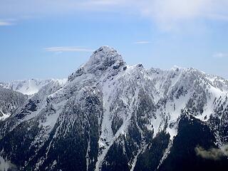
This week started with grand ambitions which, as often happens, did not survive the deteriorating weather forecast. Instead of a bluebird weekend, we were going to have a decent day Saturday followed by rain/snow on Sunday. Then there was the usual Friday ritual of figuring out plan B, then plan C, and so on. After a flurry of suggestions, we settled on Mount Price.
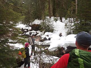
In the morning, as I approached North Bend, I could only see about 1000 ft of Mt Si below the cloud ceiling. Things were looking good for an early start until I got to the end of the pavement on the middle fork road. The road gets pretty rough fairly quickly. I was concerned my van wouldn't make it t the end. After a few questionable decisions to go for it, I ended up at the Dingfort Creek trailhead considerably later than planned. Fletcher and Fred were already there and Eric and Damon would soon arrive. Much to our surprise, the trailhead was quite busy. Someone had talked to some of the other groups and found out that one of the other groups was heading for Price also.
We gathered up our gear and headed out. The trail started out snow free, but it wasn't long until we hit a few snow patches, then bigger patches, then continuous snow. At about 2 miles we put on the snowshoes. We followed the tracks of a party ahead of us until they turned toward Sorcery Mountain. We then dropped down to the creek and looked for a way across. It took a little scouting, but we found a safe way across.
 Scouting the creek 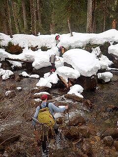 Crossing the creek 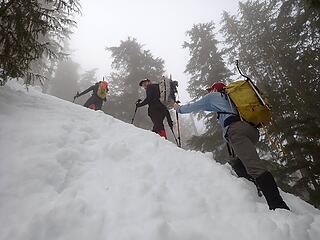 Steep Bit 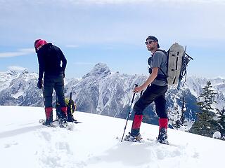 On the summit 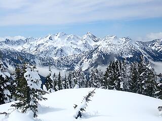 Chair Peak, Kaleetan, Roosevelt, Snow Lake 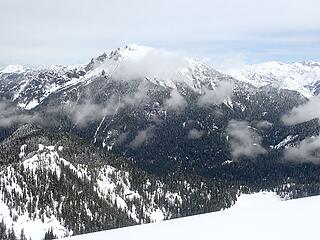 Big Snow 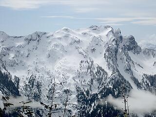 Snoqualmie 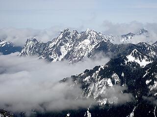 Garfield 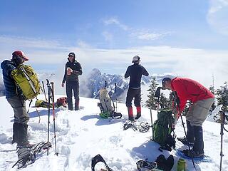 Hanging out on the summit 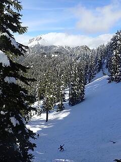 The descent 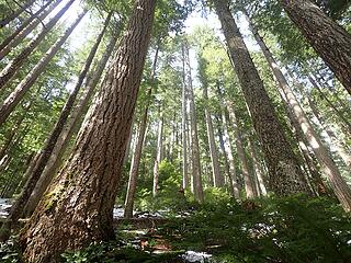 The forest
 Now I Fly Now I Fly
Now I Fly |
| Back to top |
  
|
|
Fletcher
Member

Joined: 29 Jul 2009
Posts: 1870 | TRs | Pics
Location: kirkland |
|
Fletcher
Member
|
 Sun Mar 28, 2021 9:12 pm |
|
|
Thanks for the write up Dave! Really enjoyable day out.
|
| Back to top |
|
|
iron
Member

Joined: 10 Aug 2008
Posts: 6392 | TRs | Pics
Location: southeast kootenays |
|
iron
Member
|
Sun Mar 28, 2021 11:24 pm |
|
|
|
| Back to top |
|
|
Gimpilator
infinity/21M

Joined: 12 Oct 2006
Posts: 1684 | TRs | Pics
Location: Edmonds, WA |
That looks great. Thanks for the report.
|
| Back to top |
|
|
RichP
Member

Joined: 13 Jul 2006
Posts: 5634 | TRs | Pics
Location: here |
|
RichP
Member
|
Mon Mar 29, 2021 8:35 am |
|
|
Price is a nice summit. It's a fairly long one in summer so i'm sure that other group was grateful for the broken trail.
|
| Back to top |
|
|
puzzlr
Mid Fork Rocks

Joined: 13 Feb 2007
Posts: 7220 | TRs | Pics
Location: Stuck in the middle |
|
puzzlr
Mid Fork Rocks
|
Mon Mar 29, 2021 2:57 pm |
|
|
I'm impressed you did this route without running into big problems with steep and cliffy areas. You must have planned well. Previous reports have not been encouraging and scared me away!
I notice in sushihq's Flickr feed a great use of slope shading to avoid steeper areas.
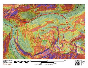 My GAIA track with slope angles.
|
| Back to top |
|
|
Mike Collins
Member

Joined: 18 Dec 2001
Posts: 3096 | TRs | Pics
|
When I climbed Price on the downclimb I happened upon a Mylar balloon with a note attached. It read This is BRITTANYS birthday party. Call [number was no longer in service when I called] if you find this note. Sammy, Windy, Candi, Tabitha, Kelly, Brittanys Mom If any of the members of this forum were at that party then yes, the note has been found.
|
| Back to top |
|
|
raising3hikers
Member
Joined: 21 Sep 2007
Posts: 2344 | TRs | Pics
Location: Edmonds, Wa |
it was fun getting out with everybody. the views were much better than i expected up there. i think we made the right call on our summit choice after 20 different ideas were thrown around during the last few days
|
| Back to top |
|
|
Eckels
Member
Joined: 25 Feb 2021
Posts: 6 | TRs | Pics
|
|
Eckels
Member
|
Fri Apr 02, 2021 2:40 pm |
|
|
Looks like a great trip!! I was camped out by Gravel lake almost visible in one of your shots that day!! If you got any more clear shots of all the North Facing terrain across the valley from Thompson to Chair I'd love to see them! We we're poking around looking at what we could ski without running into cliffs 
|
| Back to top |
|
|
MangyMarmot
Member
Joined: 06 Apr 2012
Posts: 474 | TRs | Pics
|
Eckels, I looked through my photos and found two more of the area you mentioned. They aren't great, but that's all I have. Hope you find a good line.
 Thomson 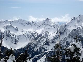 Red Mountain
|
| Back to top |
|
|
neek
Member

Joined: 12 Sep 2011
Posts: 2337 | TRs | Pics
Location: Seattle, WA |
|
neek
Member
|
Mon Apr 05, 2021 9:08 pm |
|
|
Went up there today. Really good conditions. Snowshoes on the way up, crampons going back down, minimal postholing. Seems like the route has seen a bit of activity in the past week; there's a pretty well established track all the way.
|
| Back to top |
|
|
MangyMarmot
Member
Joined: 06 Apr 2012
Posts: 474 | TRs | Pics
|
Nice trip Neek! Looks like you had great weather up there.
|
| Back to top |
|
|
RichP
Member
Joined: 13 Jul 2006
Posts: 5634 | TRs | Pics
Location: here |
|
RichP
Member
|
Tue Apr 06, 2021 3:33 pm |
|
|
Ooh, I like that 360 summit view, neek. Make it full size and spin it around and it feels like being there.
|
| Back to top |
|
|
kitya
Fortune Cookie

Joined: 15 Mar 2010
Posts: 842 | TRs | Pics
Location: Duvall, WA |
|
kitya
Fortune Cookie
|
Thu Apr 15, 2021 7:57 am |
|
|
I too decided to be greedy and go up Mount Price yesterday (4/14/2021) and after weekend snowstorm and warm weather snowmelt the established route was completely gone, so I got to break trail in the soft snow all the way, fun! I brought ice axe and crampons too, but I didn't use them and they would have been not useful anyway - the snow was just too soft and the route is very easy.
I used your way (from gpx track posted by the mountaineers group) on the way up. It is surprisingly nice: no evil bushwhack, almost no steep parts. The main ridge to the top is just so gentle and wide. Unfortunately it was very warm and I had no clouds or fresh snow on the trees, but I still liked the views.
I couldn't see much of Hester Lakes from the summit (because of the cornice) so I decided to make a lollipop and check them out on the way back. I used the other ridge along the lakes to go down. It is steeper and more narrow, with some ups and downs. At one point it became knife edge with steep drop offs on both side and with soft snow I couldn't go that way anymore. So I dropped down directly through steep, but very forested, slope.
After that it was just super mellow but very long walk through Hester creek valley down. Lots of big trees, lots of creeks and swamps and still lots of snow.
Didn't see any human tracks or humans all day, but lots of varied thrushes and robins in the forest.
|
| Back to top |
|
|
Redwic
Unlisted Free Agent

Joined: 23 Feb 2009
Posts: 3292 | TRs | Pics
Location: Going to the Prom(inence) |
|
Redwic
Unlisted Free Agent
|
Fri Apr 16, 2021 2:56 pm |
|
|
I would like to head out there, sometime. Looks like a great destination.
Any takers, and anyone with a high-clearance vehicle?
60 pounds lighter but not 60 points brighter.
60 pounds lighter but not 60 points brighter.
|
| Back to top |
|
|
|
|


