Forum Index > Trip Reports > Hard Day Harvey Slot Canyon - March 9 2021
 Reply to topic
Previous :: Next Topic
Author Message
Matt Lemke
High on the Outdoors


Joined: 15 Jul 2010
Posts: 2052 | TRs | Pics
Location: Grand Junction
Matt Lemke
High on the Outdoors
PostTue May 04, 2021 7:06 pm 
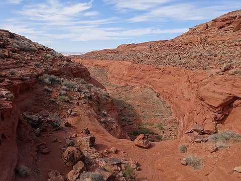
The day after Josh and I went down Alcatraz Canyon, we opted to go for an even bigger and more serious canyoneering objective. Hard Day Harvey, also known as the east branch of the east fork of Sevenmile Canyon, is located way down on the Ticaboo Mesa area of southern Utah not too far from the Bullfrog Marina. It was a long drive on the rough Ticaboo Mesa dirt road out to the NPS sign just over 10 miles from the highway. See location and driving directions from Hanksville here. Again, a good map of the Ticaboo Mesa area is necessary as there are many roads crosscrossing the mesa many of which are jeep roads. Getting to Hard Day Harvey definitely tested my trusty stationwagon, but I was able to make it out there with copious amounts of careful driving. There was really only one real concerning spot, where the road drops down a small but sandy hill close to the Hard Day Harvey parking spot. Getting back up this hill on the way back required gunning it to gain momentum with just a front wheel drive car but I made it. Other reports about this canyon say high clearance 4WD is required, but I once again proved them wrong cool.gif We got a relatively late start arriving at the small parking area where the road crosses the inconspicuous drainage. After packing up our small bag which consisted of just some water, snacks and a 60 meter rope (only a 30 is needed but I was glad I had my 60...read on), it was only a 10 minute walk or so to the first rappel, which dropped down about 30 feet where the Carmel formation meets the unusually thick Page Sandstone. Many areas in southern Utah do not have the Page Sandstone present, but the Ticaboo area certainly does, and it is a short cliff former in these parts. A large rock with good webbing already in place made a perfect anchor. Down we went, now fairly committed to continuing down canyon. This would end up being my favorite canyon I have ever done. After a decent amount of distance (a mile perhaps) more or less walking down an open canyon we started dropping deeper into the Navajo Sandstone and the fun began. Many short downclimbs, twists and turns and shimmying was had but nothing too difficult. A short area of rockfall was encountered that required some boulder scrambling to pass through, and after another 20 minutes of squeezing we came to a gigantic rockfall in the canyon which prevented any possible downclimbing option. There was one tiny spot one could squeeze through a tiny hole on the bottom of the biggest house sized boulder, but only a small child would fit. Adults need to scramble to the top of the large boulder where an anchor of webbing is found. It was a short but exposed traverse near the edge to reach the anchor, and the rappel dropped about 40 feet. Immediately below this drop we continued down, still utilizing the same anchor to rappel down another 30 foot drop. This was one nice thing about having the 60 meter rope so we didn't have to break this up into two rappells. Once down we pulled the rope and quickly realized the canyon was about to get much darker.
The first rappel 10 minutes from the car
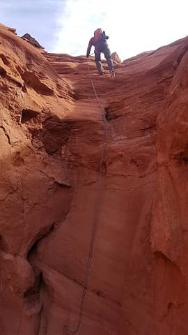
Josh making the first rappel
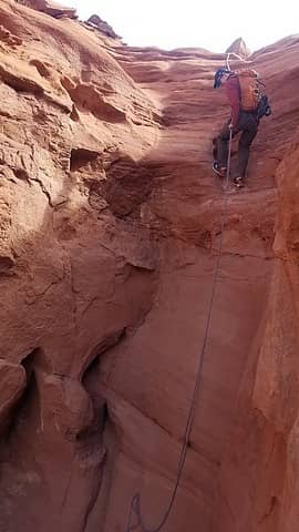
First rappel
First rappel
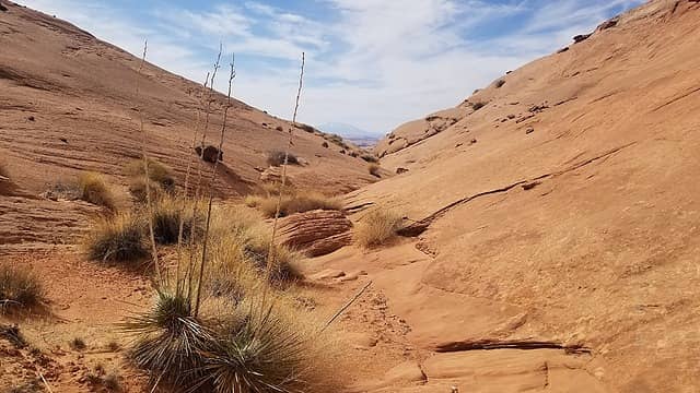
Easy terrain below 1st rappel
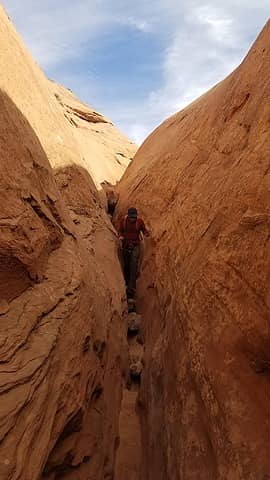
Some shallow narrows early on
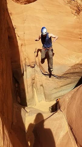
Occational jump required
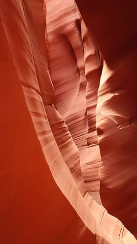
Photogenic slot
Photogenic slot
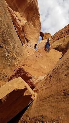
Small rockfall area before 2nd rappel
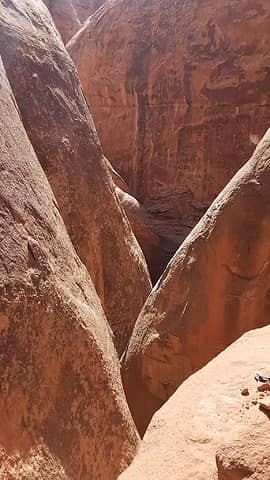
View down from the 2nd rappel anchor
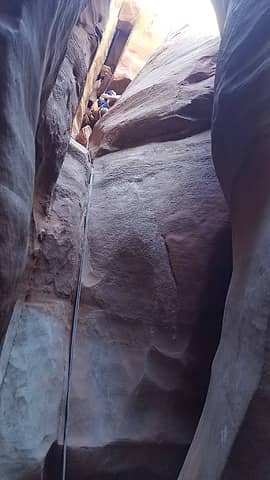
Josh making the 2nd rappel
Continuing down the canyon, we had already done a whole lot of fairly strenuous canyoneering when comparing to other canyons we've done, and after looking at the map we realized we still had a LOT more to go! The canyon did not really relent at all, and we continued for probably another hour squeezing through. There were some pretty long stretches of areas narrow enough where we had to walk sideways for periods long enough the skin on my hands started becoming raw from constantly bracing myself on the rough canyon walls. We passed by at least 4 or 5 openings where the Navajo was crosscut with a side canyon coming down from both sides. The main canyon would turn and follow these fault-like features for a hundred feet or so before sharply turning down and narrowing up again. In reality these are erosional patterns consistent with the Navajo where dones and fins are separated by linear drainage cuts that makes travel over the surface of the Navajo formation quite difficult as these deep cuts are very difficult to negociate around, often requiring large round-about routes. On perhaps the 5th opening since the 2nd rappel, we found an anchor sitting out in the open wedged in a crack, and this was the 3rd rappel noted in the route description. A drop of 30 more feet brought us into the most difficult and tight part of the slot. This final section down to the junction with Good Day Jim canyon is in my opinion one of the best section of slot canyon in Utah and certainly my favorite I have done. We first came to two spots where the canyon was so narrow, I had to turn sideways, with my knees on the canyon bottom, left elbow leading also on the bottom with my right hand pointed straight up or behind me dragging the rope. In this position, I would then worm my way across, moving the widest part of my body (my chest) slightly up and down looking for tiny increases in width between the two walls to allow me to fit through. It cannot be stressed enough that you need to be thin do fit through this canyon! You all know how thin I am and it was a close fit for me (although being very tall does also make it so I have a wider chest than shorter people). Josh did not have to do any "searching" for wider areas to be able to squeeze through. After this extremely narrow section, we came to the first of three difficult downclimbs. This first one dropped probably 20 feet and involved wedging our body against each side of the canyon and friction sliding down the first half, then transitioning into a stemming downclimb when the canyon widened a bit. The final 3-4 feet required a jump. Shortly after this downclimb, we came to the second one which was very similar. The third one was more difficult though. Initially I started wedging and friction sliding down but I noticed the canyon opened up quite a bit with still at least 20 feet to drop and I did not really see a way to safely downclimb this without slipping, and potentially decking 20 feet below. So I upclimbed back to the top and Josh and I worked for the next 30 minutes building an anchor. Lots of digging, finding rocks, and positioning rocks in such a way that we could weight the webbing and rappel down. Really all we did was bury a pile of rocks, with the webbing tied around the bottom rock in the pile. Filled it with sand and hoped it would hold! eek.gif This would be our 4th rappel, and I was suprised there was no existing anchor. I couldn't imagine everyone else who goes down this canyon was able to downclimb it...or maybe I am just a beginner canyoneer...or maybe only experts typically go in this canyon I don't know. It held, and josh and I made the rappel down. Just a few minutes after this final obstacle, the canyon opened up and the last minor difficulty were a handful of large potholes that were all thankfully dry. They were easy to scramble out from and soon enough, we reached the junction of Good Day Jim canyon coming in from the right. Here we took a nice rest and contemplated our route back to the car, as we had a couple options.
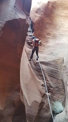
Josh on the 3rd rappel
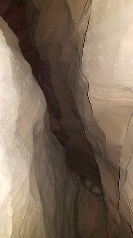
Flash required in this dark spot
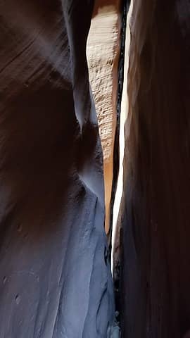
Looking down our 4th rappel
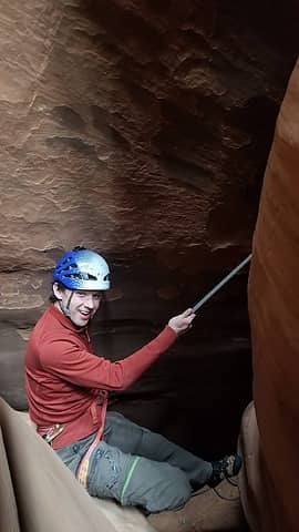
Josh finishing the 4th rappel
We checked the time, and it was 3:30pm, which meant we only had a few hours of real daylight left, and there were clouds rolling in so the decision was pretty easy. We would need to take the shortcut exit route that climbs out to the rim on the west side of the lower part of Good Day Jim canyon. Unfortunately I had forgotten to take a photo of the page in Kelsey's book that describes exactly where the exit route is...all I had was the page with his hand drawn map. I figured it wouldn't be too hard to find though, so we began upclimbing from the bottom of Good Day Jim. I figured we would come across a class 3 exit that would be pretty obvious, but after 30 minutes of strenuous canyoneering in reverse, where we had to upclimb some pretty steep stuff, including a vertical step and a squeeze through a chockstone, we still had not found any obvious exit route to the west. We finally reached one of those straight faultline type features that looked like it would go up, but was certainly not scramble terrain, so we continued another couple hundred feet or so up canyon around one more turn and a larger opening presented itself with a lower angle slab of Navajo that looked promising. So we began to ascend the steep slickrock. After ascending maybe 150 feet the terrain was getting more difficult. Josh was convinced he would be able to climb up through an overhanging bulge with no handholds on the upper lip (something I was able to see from my location off to the side more). I had him wait while I scouted a route that continued up the steepening slab and I made a committing and scary move up to the next ledge...something I did not want to have to downclimb. I then continued up a bit further to the top of a large ledge/dome. I walked this ledge towards the direction of our exit and the terrain only got worse at the end of the large ledge. Vertical rock above me on all possible routes blocked passage, and the only way back down was to downclimb the slickrock I came up. Not wanting to do that, and considering I thankfully had the rope on my back, I yelled down to Josh I was going to try and rappel down. I lowered the rope to him so he could tie my harness to it and I pulled it up (he had the pack) and I looked around for anything that could work as an anchor. All I found was a poor excuse for "rocks" with everything I touched crumbling into dust. Along the back of the large ledge I was on, against the vertical wall above it was a 3-4 inch wide crack that went down towards the canyon bottom on a lower angle. I scrambled down this as far as I could, but the last 25-30 feet I knew were vertical. My only option was to try and wedge something in the crack as an anchor, but the only rocks around were fairly small and very low quality. With lots of hesitation, I fished the rope around a series of 3 rocks that I gingerly placed in the crack in such a way they would not pop out, but there was no guarantee they wouldn't crumble when I weighted them. Also an unfortunate thing was that we didn't have any more webbing or cord, having used what we had to make the anchor for our unexpected 4th rappel in Hard Day Harvey. I was forced to fish the rope manually around the wedged rock anchor I made without bumping them, which took a ton of effort considering I am standing with my feet wedged into the crack leaning up against the wall to my left right above a sizable drop without being anchored into anything at this point. With enough cussing I got the rope fed through and thrown down below me where Josh confirmed both ends were on the ground. After plenty more hesitation, I put myself on rappel and downclimbed as much of the terrain as I could, but when the drop became vertical, I hesitated again and with a leap of faith fully weighted the anchor and smoothly, but very quickly rappelled the final 25 feet to the ground. That definitely went down as the single worst rappel anchor I have ever used...and I have rappelled on single micronuts more times than I care to admit. Unfortunately we were unable to retreive the rope as it was wrapped around the rocks I wedged into the crack. I was hopeful that by just flicking the rope up I would be able to rip the rocks out and get the rope but it wasn't happening. Not only that, there is a rappel below the junction of the two canyons to access the longer exit routes further down canyon, and the final rappel of Good Day Jim was just a few more minutes up canyon from where we were, blocking any chance of upclimbing any further. We were now fully committed at finding the escape route Kelsey showed on his map. The only other place it could have been was the spot just a few meters back down canyon, so we began upclimbing the wide gully. Thankfully, it went, but it went at low 5th class on horribly rotten rock. By this point we only had maybe another 90 minutes of light, so I pushed and climbed as fast as I could. The crux was definitely a steep blocky climb on stair steeping blocks against one wall of the wide chimney, with a large boulder at the base that also required chimneying to get up. Eventually though the steepness relented and we were able to walk on lower angle slickrock. When I finally saw the Page Sandstone rim I knew we were in the clear and we took a much needed break. All our food and water were gone at this point, but thankfully it was not hot. It actually began lightly drizzling with the cloudcover. We continued walking along the Page/Navajo contact back along the west rim of Good Day Jim until we hit the apex of the Page Sandstone where the drainage itself cuts down through it. At this moment in time, the sun passed through a tiny hole in the clouds just as it went below the horizon, and on the Carmel just 30 feet above us we saw an insanely intense red/pink glow of sunlight...if only we were 10 minutes earlier we would have been able to capture a sight for the ages, but unfortunately being at the base of the Page, still inside the canyon we missed it frown.gif That was super disappointing.
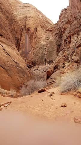
Starting up Good Day Jim
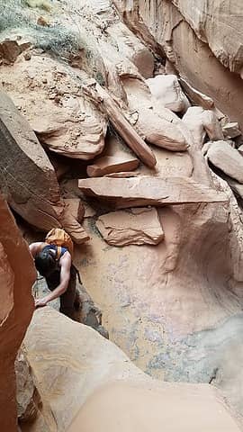
Climbing one of the ascends
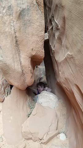
Squeeze through a chockstone
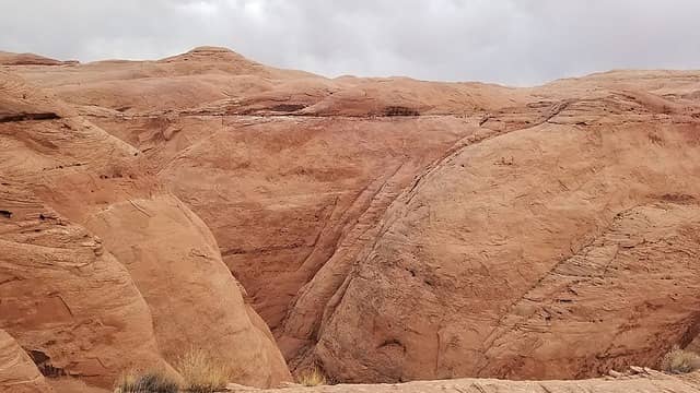
View from the top of our escape route
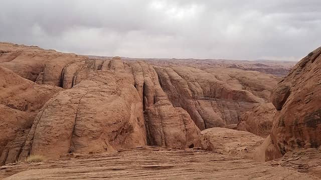
Notice the straight cuts in the rock
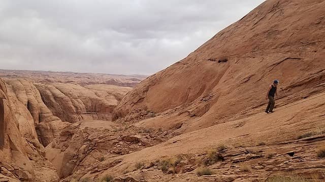
Finally on easier terrain
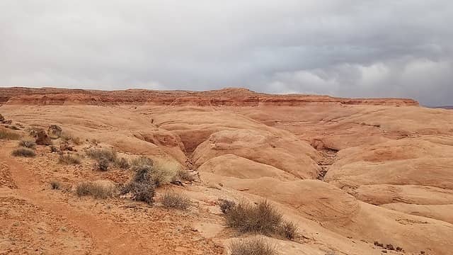
Page/Carmel rim getting closer
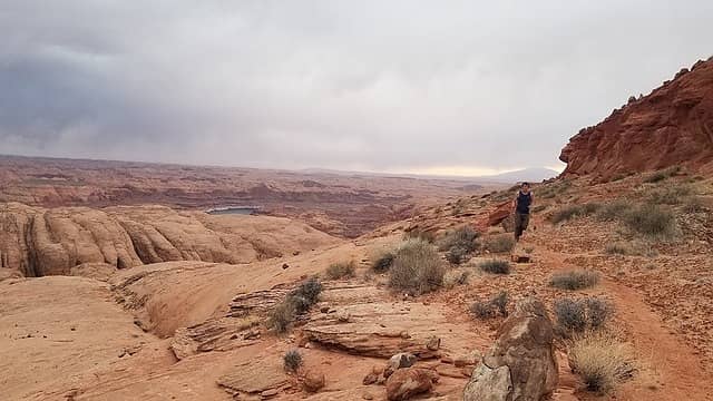
Hiking back towards the car
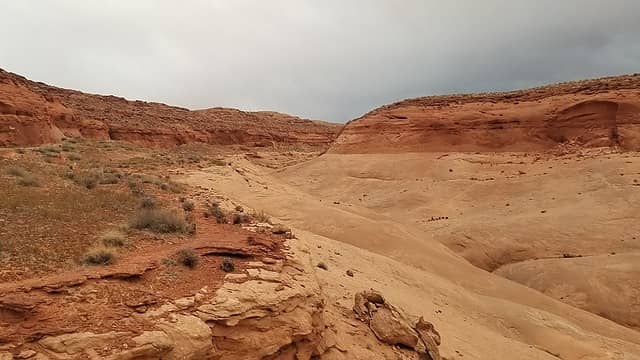
Nearing the end
Nearing the end
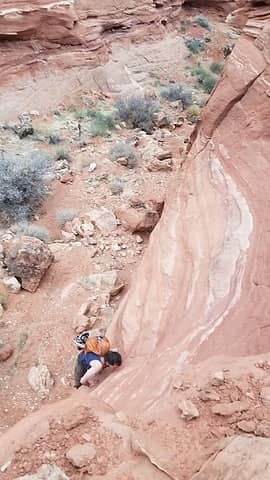
The final climb up the Page Sandstone
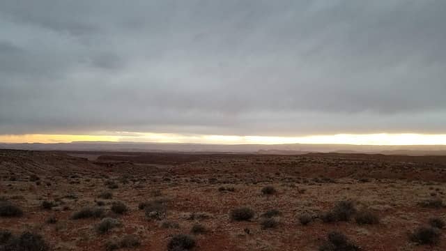
Twilight view as we reached the car
Just then we also realized the 20 foot climb up to the top of the Page Sandstone was not going to be trivial...another move or two of low 5th class on slick slabby rock was required to get to the top...only then were we able to mindlessly walk on the flatlands of the Carmel formation back to the car, which was still 3/4 of a mile away, but we reached it just as it got dark. We did not waste any time starting the drive back though, as I knew we still had to drive back up the sandy hill before we could say with near 100% certainty we would be fully "out of the woods". Under dusk light, I was able to see the hill approaching, and see the road just enough to comfortable gun it without risking hitting a hidden rock, and on the first try, not without spinning front wheels, we made it up. The rest of the drive was still slow, but we made it back to the highway (where we still saw no one driving) and parked for a while. We ate some more food, Josh cooked dinner and we contemplated where we wanted to go next. We ended up deciding to take the next day off and just drive...all the way to the Mexico border (almost) and prepare to climb Baboquivari Peak in far southern Arizona! Thinking back, even though that rope I left was more than ready to be retired, and not any real loss, I hope to be able to head back there and retreive it somehow so it's not sitting there for everyone who descends Good Day Jim in the future to see...I will probably have to get creative on how I do that though, as I certainly do not want to rappel from that ledge again! All in all though, Hard Day Harvey is my favorite slot canyon I have done, and for anyone in the future who wishes to do it, I would recommend starting early, and doing the longer hike back, which follows the east side of the canyon after an easier scramble out about 3/4 mile downstream from where the two slots converge. Then, the hike back on the Navajo slickrock is extremely scenic with Lake Powell visible directly below on the right as you hike back. I plan to return to this area just to do this hike, as I know it is incredibly stunning. See the map below that indicate the two canyons (Hard Day Harvey and Good Day Jim) and the excape route we took.

The Pacific coast to the Great Plains = my playground!!! SummitPost Profile See my website at: http://www.lemkeclimbs.com
Back to top Reply to topic Reply with quote Send private message
iron
Member
Member


Joined: 10 Aug 2008
Posts: 6392 | TRs | Pics
Location: southeast kootenays
iron
Member
PostTue May 04, 2021 10:30 pm 
josh is all grown up! what a difference a decade makes. looks pretty tight in those slots...

Back to top Reply to topic Reply with quote Send private message
Chief Joseph
Member
Member


Joined: 10 Nov 2007
Posts: 7697 | TRs | Pics
Location: Verlot-Priest Lake
Chief Joseph
Member
PostTue May 04, 2021 10:46 pm 
Yes, better watch your weight or get stuck! Great photos, and Matt you are one excellent TR writer! borank.gif

Go placidly amid the noise and waste, and remember what comfort there may be in owning a piece thereof.
Back to top Reply to topic Reply with quote Send private message
zephyr
aka friendly hiker


Joined: 21 Jun 2009
Posts: 3370 | TRs | Pics
Location: West Seattle
zephyr
aka friendly hiker
PostWed May 05, 2021 10:27 am 
I agree. These are some excellent photos and story telling. I can't believe some of the places that you all squeezed through. yikes! It was tough reading that escape route story. That's living close to the edge. 'Glad you both made it out of there and lived to tell the tale. ~z

Back to top Reply to topic Reply with quote Send private message
Stefan
Member
Member


Joined: 17 Dec 2001
Posts: 5090 | TRs | Pics
Stefan
Member
PostWed May 05, 2021 11:49 am 
excellent write up! and pictures! good on your two!

Art is an adventure.
Back to top Reply to topic Reply with quote Send private message
GaliWalker
Have camera will use


Joined: 10 Dec 2007
Posts: 4929 | TRs | Pics
Location: Pittsburgh
GaliWalker
Have camera will use
PostWed May 05, 2021 11:49 am 
Chief Joseph wrote:
Great photos, and Matt you are one excellent TR writer!
I agree! Excellent report; really fun to follow along. Having said that, I have a teensy tiny quibble. smile.gif For this report I found it a little bit harder to match the photos to the words when compared to your (equally excellent) "Alcatraz Canyon" TR, in which I thought the ratio was perfect. Maybe, it’s because this slot was so much more involved? Possibly, breaking each set of photos into two or more smaller sets, and putting them closer to the words would have helped (at least for me)...? smile.gif Anyway, that's a small quibble in an otherwise thoroughly enjoyable read. up.gif up.gif up.gif

'Gali'Walker => 'Mountain-pass' walker bobbi: "...don't you ever forget your camera!" Photography: flickr.com/photos/shahiddurrani
Back to top Reply to topic Reply with quote Send private message
cascadetraverser
Member
Member


Joined: 16 Sep 2007
Posts: 1407 | TRs | Pics
cascadetraverser
Member
PostTue May 11, 2021 6:49 am 
Wow! Well done....Impressively narrow and challenging Canyoneering trip. And I thought LDH was tough wink.gif

Back to top Reply to topic Reply with quote Send private message
Roly Poly
Member
Member


Joined: 02 Jan 2013
Posts: 711 | TRs | Pics
Roly Poly
Member
PostTue May 11, 2021 5:30 pm 
Wow, Josh looks really different now.

Back to top Reply to topic Reply with quote Send private message
Hiker Mama
Member
Member


Joined: 25 Jun 2006
Posts: 3451 | TRs | Pics
Location: Lynnwood
Hiker Mama
Member
PostWed May 12, 2021 8:03 pm 
Oh man! I feel panicky and claustrophobic just looking at your photos! What an amazing place.

My hiking w/ kids site: www.thehikermama.com
Back to top Reply to topic Reply with quote Send private message
   All times are GMT - 8 Hours
 Reply to topic
Forum Index > Trip Reports > Hard Day Harvey Slot Canyon - March 9 2021
  Happy Birthday mtnwkr!
Jump to:   
Search this topic:

You cannot post new topics in this forum
You cannot reply to topics in this forum
You cannot edit your posts in this forum
You cannot delete your posts in this forum
You cannot vote in polls in this forum