Previous :: Next Topic |
Author |
Message |
Alden Ryno Member
Joined: 04 Jun 2019 Posts: 150 | TRs | Pics Location: Issaquah, WA |
A retroactive trip report for a peak that probably has too many TRs on NWHikers already.
I love to see and use different reports from different parts of the year and with peaks under different conditions. I'm writing because of that, I think that I had some relatively interesting conditions on the summit pyramid.
I wanted to write this earlier, but I finally have time with graduate school ending (not for the term, I'm graduating: woo!!) I actually have some time to breath outside of work, school, relationship, mountains, and life.
Trip Stats: 15 miles, 6,700' gain.
Route: SE Rib (more on this later)
Gear: Poles, Axe, Crampons, Snowshoes (not truly needed)
We've experience a few different long, hot streaks this spring and this was the beginning of the one in the middle of May. Given that, I had some trepidation about the temperatures at altitude prior to this outing.
I arrived at the Shannon Ridge TH the night before and the temperature was around 55 degrees. Warm enough to make car camping not the most fun with the windows practically closed due to mosquitoes.
I awoke at 0230 and was on the move by 0300. I wanted to take advantage of the coolest temps for as long as possible since freezing level was projected to be all the way up near 7,000 feet. In reality, however, it wasn't quite 40 degrees at the TH (~2,600'). While I was colder than expected, I was immensely grateful.
Snow began about 1.5 miles up the trail and remained. It was frozen hard. YES! Travel with boots only would be great unless it got too steep any time soon, which I didn't expect.
I made it onto the ridge as light began to fill the farthest reaches of the sky then sunrise (0530) hit minutes after I crossed from Shannon Ridge to the Sulphide Glacier Basin. The warm light felt great in the sub-freezing temps. There, I took my first water and snack break while donning crampons for the steep traverse to the lowest reaches of the Sulphide.
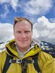
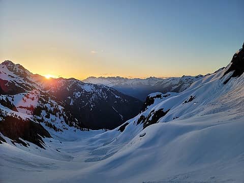
Privileged sunrise
Given the early season conditions, the freezing temps, the bootpack, and general knowledge of the late season Sulphide morphology, I deemed the risk low enough to do this trip alone.
I made easy travel upward and glimpsed my view of the summit pyramid and my first humans about the same time. There were four skiers: I may have company on the summit!
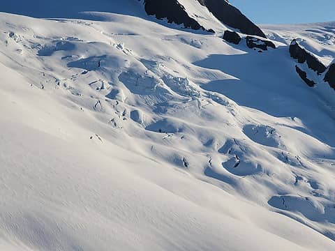
Lumpy land is a no-no
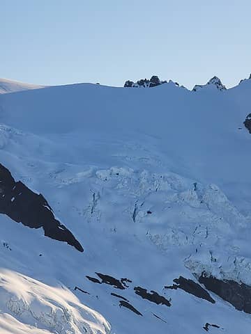
 Crystal Glacier
Travel was easy and the snow surface was hard. It wasn't until I intersected the Hourglass that I was able to "scrape" any surface ice/snow by grazing my pole tip along the surface. Hopefully that description makes as much as to y'all as it does in my head...
About 200' below the base of the pyramid, I dropped my snowshoes, which had been happily on my pack the entire time so far. I anticipated that late morning and afternoon temps would turn the snow to slush.
As I approached the standard gully, I noticed how hard the surface still was and how little "snow" remained. It seemed to have been scraped clean. Whether it was actually amended (wording?) by melt/freeze cycles or sloughed off by skis, I don't know. At the time, I was certain that skiers (likely not the ones I had seen) had killed any chance of purchase in the snow. In retrospect, I'm less sure it was human caused.
Around this time I realized that the skiers weren't there to summit, just to ski! They hopped onto Crystal Glacier and skied to its belly.
I also realized that the standard gully wasn't easily viable. I probably could've kicked steps in the ice all the way up, but that would have been brutal and would've sucked hard. As an alternative, I noticed that the SE ridge looked not so shabby. It was interspersed with rock, ice, and snow, none of which seemed prohibitive from below.
I gave it a shot and figured that I could traverse to the to the gully if I felt overly exposed, hit a vertical section, or it just didn't feel right. There was a notch about 100 to 200 feet above the crossover to the Crystal Glacier that I aimed for to gain the ridge.
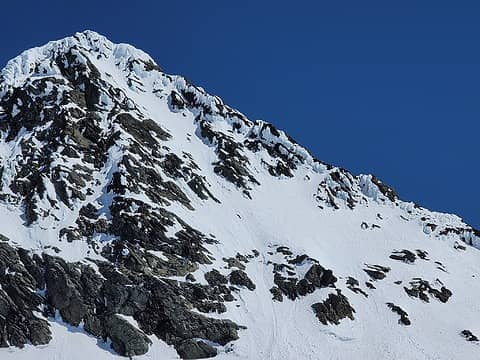
1 label Looks worse now than it did then...
Armed with an axe, a shortened (intentionally) pole, and my crampons, I scuttled to up to the ridge to encounter nice, steep walking terrain. There were scramble bits here and there with one section that I used an affixed ice finger to split half of my body on the ice and half on the rock. This was my crux and further investigation revealed the probable crux of the actual SE Rib route.
It took a while to make my way up since I verified that things were solid before placing weight. The exposure was extreme, but nothing too wild given I wasn't (entirely) foolish with my body placements. However, I eventually made it to the top of the rib and, boom, the summit! There were some pre-made steps (days prior) for the last 20 feet, but no signs of human activity that I noticed elsewhere.
I topped out about 0930, a bit under an hour and a half after dropping my snowshoes about 200' below the pyramid. While there, I decided that I didn't want to reverse the route down so the gully was going to be my choice. Still worried about the solidity of the snow and ice, I waited until 11am to make my descent. Direct sunlight has just begun to hit the gully when I began my ascent, so a few hours should at least make it marginally better.
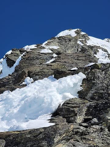
The only picture I took while on the route. Where my crux was. I skirted up the snow on the right half until halfway up the image then scooted across a ledge to the left side and used that snow, ice, and rock to get to the top of this bit.
When I told Rikki about my route that night in the car, she quizzically asked "you mean the southeast rib?"
Me: "Uh... I guess so, it was a ridge that extended to the southeast."
Her: "yeah, that a 5.4 trad route in summer"
Me: "oops"
Her: "..."
Me: "not again" (It was a hilarious conversation).
Oops, all fifth class. Really though, I didn't encounter anything that I would call fifth class. Then again, there's something wrong with my brain, so who knows. My track goes up what that route is, so I did it, though I believe that the snow and ice helped easy the ridge.
Summit porn deposit in 3...2...1...
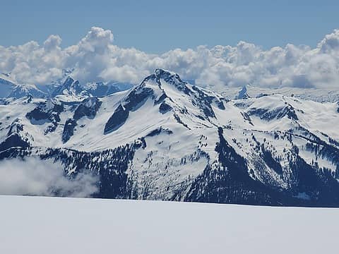
Not from the summit, but it fits with these
When I began down, the stuff was still crazy firm. The top bit was the steepest but also the easiest to kick into. Below the top 50 feet or so, the angle remained the same until the gully fanned out and it remained tough to make progress down. Here, I wished that I had two ice tools (or even once) compared to the axe. My grip on the axe was a bit tiring and the balls of my feet weren't the happiest campers either. Eventually, deliberately, and slowly, I made it down to a point where I could finally face away from the mountain and plunge step. It was easy travel after that.
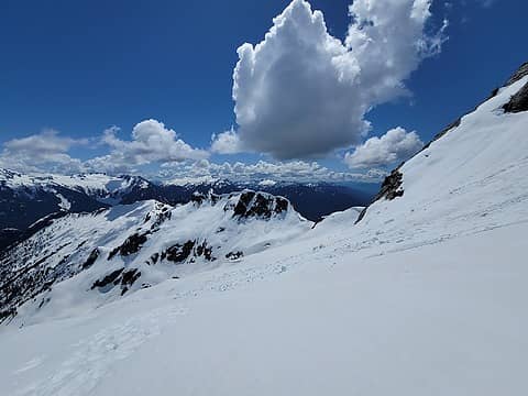
Near the traverse to Shannon Ridge on the way out
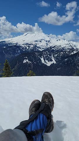
I took another break at my snowshoes, which had begun to sink a bit in the softening snow. Hmmm. The snow was still firm enough that I didn't sink any more than an inch or two with each step, so I strapped the snowshoes back to my back until travel without them became burdensome. I did eventually put them on, but they didn't do much with side hilling (descending traverse) being the direction of travel at the time. The top few inches were slush so they did help, but not significantly so. I had them on for about an hour, probably closer to half of one.
I took an extended break around 1300 once back onto gentle terrain on Shannon Ridge and out of the objective hazards of the glacier in the sun. The view of Koma Kulshan was splendid.
Chillin'
I was back to the car a bit after 1500 for a roughly 12 hour day. Thankfully, I felt great and wasn't much tired, especially with Silver Star the next day (a repeat for me, the 64th Bulger for my partner).
With a summit of Shuksan to my name, I've excitedly and happily finished all of Washington's 9,000 foot Bulgers. The true T100 may come, but we'll see. Gotta snag 8 more Bulgers before those come to the fore.
raising3hikers, Tom, SeanSullivan86, Snowdog, awilsondc, geyer, Cyclopath, GaliWalker
|
Back to top |
|
|
RichP Member
Joined: 13 Jul 2006 Posts: 5634 | TRs | Pics Location: here |
|
RichP
Member
|
Sun Jun 06, 2021 9:22 am
|
|
|
One can never see too much of Shuksan and the North Cascades in general. Nice to see you've got someone keeping you in line and congrats on finishing school.
Sallie4jo
Sallie4jo
|
Back to top |
|
|
Alden Ryno Member
Joined: 04 Jun 2019 Posts: 150 | TRs | Pics Location: Issaquah, WA |
RichP wrote: | Nice to see you've got someone keeping you in line |
She has a TON more technical knowledge than me and I trust her judgment fully. I'll be learning from her for a long time
|
Back to top |
|
|
Brushbuffalo Member
Joined: 17 Sep 2015 Posts: 1887 | TRs | Pics Location: there earlier, here now, somewhere later... Bellingham in between |
Passing rocks and trees like they were standing still
|
Back to top |
|
|
Midnight Slogger 'Schwack Job
Joined: 04 Aug 2017 Posts: 96 | TRs | Pics Location: Greater Cascadia |
Congrats on graduating!
We skied Shuksan the weekend after you, armed with the good omen of your brief Facebook post. We summited around noon and the snow in the standard gully was still very firm (I think freezing level was 9k+). About six or seven parties in front of us ended up turning around due to the firmness. This was all somewhat surprising so I'm glad you took the time to write up this trip report.
Cheers
|
Back to top |
|
|
|
You cannot post new topics in this forum You cannot reply to topics in this forum You cannot edit your posts in this forum You cannot delete your posts in this forum You cannot vote in polls in this forum
|
Disclosure: As an Amazon Associate NWHikers.net earns from qualifying purchases when you use our link(s).
|