| Previous :: Next Topic |
| Author |
Message |
Bluebird
suffering optional

Joined: 22 Jan 2014
Posts: 199 | TRs | Pics
Location: United States |
|
Bluebird
suffering optional
|
 Sun Jun 06, 2021 7:54 am |
|
|
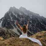
Trace G and I climbed the big boy last Wednesday via Granite Lakes TH.
Snow level on the road trail was a surprising 3500 feet, but consolidated with minimal postholing. We sidehilled on steep very firm snow around Revolution, almost wanted crampons since we often needed 4 or 5 kicks to get a step created! On such a warm day this was a surprise. We contoured around Revolution on better snow that wasn't as firm and then descended to a mostly level traverse around 4500 elevation until at the base of Russian Butte summit block.
We ascended to a gully on climbers left, found no good transition from snow to rock so dove into the moat. The moat was very slippery. The move onto the rock had tiny hands, no feet and was wet. I was scared on this move, Eek! After a few scary moments of realizing my only option at this point was the move I didn't want to do, I went for it and then crawled my way up to easier terrain. The Gully was a waterfall, warm water... Some holds submerged but largely class 3 to 4. At the upper ridge we dove straight up and found a Cairn, ha! From here the scramble was exposed in places but easy to the summit, 5.5 hours after leaving the trailhead.
After half an hour enjoying the views, we discussed the problem of descent. I was not taking that gully back down without a rope! I suggested the steep snow of the NE face and contouring back to our route. It went, but required about 400 feet of steep snow down climbing. With consolidated snow like we had, it would have been a safer ascent route too.
After reaching our up route, we retraced our steps, roughly, to the base of Revolution, tagging the summit as well. We decided to stay on the ridge, weary of sidehilling after literal miles of sidehilling. We were pleased to find the steep ridge melted out on the scramble bits and with consolidated snow other wise. The hike from here to our dry approach shoes along the road was uneventful.
Total round trip time 11 hours. 18.5 miles and over 6500 gain. One and done for me on this route, but I do believe that doing this with spring snow and climbing the NE face is the way to go!
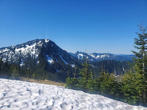 Revolution from where we started our sidehilling 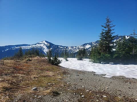 view from the road 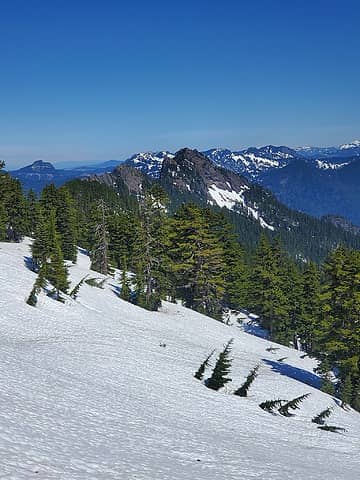 getting closer to the Butte! 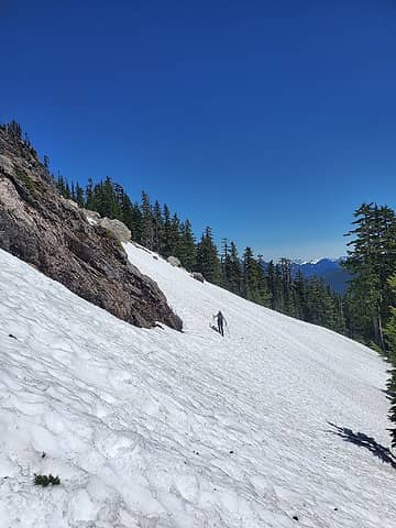 Trace approaches the base of the Butte climb 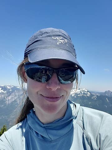 how to get back down is a problem for future Selena to solve 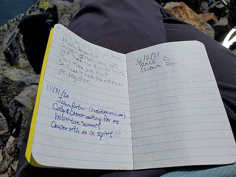 not many register signatures 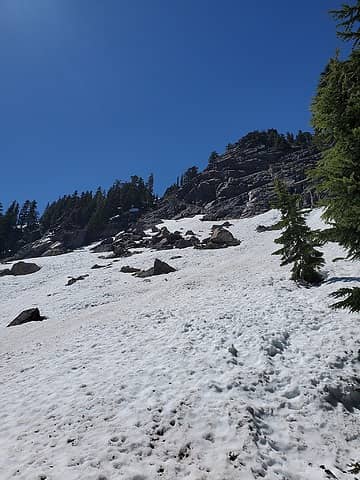 back on route after the steep snow descent 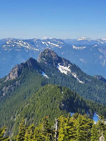 Russian Butte from Revolution. It looks far because it is. 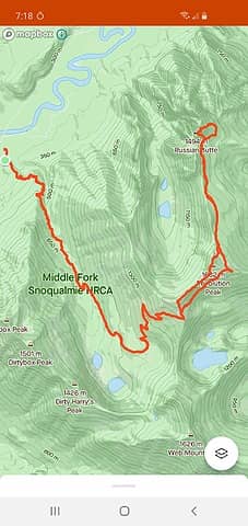 Our route
 BensonM, Tom, neek BensonM, Tom, neek
BensonM, Tom, neek |
| Back to top |
  
|
|
RichP
Member

Joined: 13 Jul 2006
Posts: 5634 | TRs | Pics
Location: here |
|
RichP
Member
|
Sun Jun 06, 2021 9:06 am |
|
|
Challenging route. I thought I would do it this way someday but may opt for puzzlr's route up from the river IF i ever do it.
|
| Back to top |
|
|
Gimpilator
infinity/21M

Joined: 12 Oct 2006
Posts: 1684 | TRs | Pics
Location: Edmonds, WA |
That's a tough peak. Nice job!
|
| Back to top |
|
|
Mesahchie Mark
A Lerxst

Joined: 10 May 2005
Posts: 700 | TRs | Pics
Location: In Wonderland |
Well done!
11 hours RT is flying!
|
| Back to top |
|
|
raising3hikers
Member

Joined: 21 Sep 2007
Posts: 2344 | TRs | Pics
Location: Edmonds, Wa |
|
| Back to top |
|
|
puzzlr
Mid Fork Rocks

Joined: 13 Feb 2007
Posts: 7220 | TRs | Pics
Location: Stuck in the middle |
|
puzzlr
Mid Fork Rocks
|
Tue Jun 08, 2021 9:49 pm |
|
|
It took me a lot of two days to do what you did in 11 hours (via that route). Kudos. And Revolution thrown in for almost free!
If I ever go back it will be via the Pratt -- a wonderfully economical route if you do it at low water.
|
| Back to top |
|
|
NBL
West Seattle Based

Joined: 08 Sep 2020
Posts: 44 | TRs | Pics
Location: 98126 |
|
NBL
West Seattle Based
|
Wed Jun 09, 2021 8:00 am |
|
|
|
| Back to top |
|
|
Bluebird
suffering optional
Joined: 22 Jan 2014
Posts: 199 | TRs | Pics
Location: United States |
|
Bluebird
suffering optional
|
Wed Jun 09, 2021 3:25 pm |
|
|
Thanks everyone! I feel so excited every time I drive by RB now! Laughing excited happy  Between that and our successful Garfield summit I am as happy as a Mforker could be <3
@puzzlr, I was looking at a map and wondering why that ridge route via the fords/Pratt isn't done by just staying on that side of the river ie, park near Granite Lakes TH at the bridge over the M.fork, continue up the side road.... and a bushwhack to the ridgeline. Is it a private property issue? Then it would be viable at even high water times since no ford required.
That said, the consolidated spring snow surely sped our ascent. I think if we had considered our descent route as an ascent route, it makes an excellent steep snow climb, although there is surely a lot of traversing to access the climb via Granite Lakes TH. Between that and our successful Garfield summit I am as happy as a Mforker could be <3
@puzzlr, I was looking at a map and wondering why that ridge route via the fords/Pratt isn't done by just staying on that side of the river ie, park near Granite Lakes TH at the bridge over the M.fork, continue up the side road.... and a bushwhack to the ridgeline. Is it a private property issue? Then it would be viable at even high water times since no ford required.
That said, the consolidated spring snow surely sped our ascent. I think if we had considered our descent route as an ascent route, it makes an excellent steep snow climb, although there is surely a lot of traversing to access the climb via Granite Lakes TH.
|
| Back to top |
|
|
|
|


