Forum Index > Trip Reports > Bandera Mountain, 2021-06-12: West Peak, True Summit, attempt at East Peak
 Reply to topic
Previous :: Next Topic
Author Message
achildinthesehills
Member
Member


Joined: 02 Jun 2021
Posts: 16 | TRs | Pics
Location: Tukwila, WA
achildinthesehills
Member
PostSat Jun 12, 2021 10:29 pm 
So there's something going on with my right knee (x-rays negative) but I told it to just deal with itself so I could finally get out two days in a row. Yesterday was a stormy but straightforward trip up and down Granite Mountain. Did I really want to brave the Ira Spring trailhead on a Saturday with a nice weather window? No, but I did anyway. Here's what happened. Okay, first the road. Yikes. Even in my big ol' 4x4 I was hanging on to my kidneys for dear life. Granted, the truck has probably needed new shocks since the first Bush administration, but still. I thought I used every inch of clearance and pound of low-end torque at my disposal, but I also just kinda assaulted the potholes rather than trying to dance around them (which is impossible in spots anyway). Regardless, if you have a low-clearance vehicle, make sure there's plenty of space in the trunk to stash all the undercarriage components that will certainly be liberated.
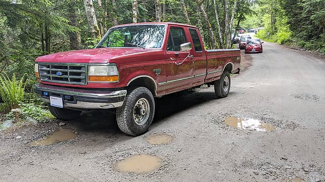
The big red vehicle got me there. The little red one got someone else there, somehow. Yes, this is a gratuitious photo.
Now, I'm always amazed that after driving a road like that for 20 minutes and seeing barely any other traffic I can arrive at the trailhead and it's an absolute zoo. It was 9:30am and the parking area was completely full, with vehicles beginning to line the road. I had hoped for more of an alpine start, but as usual with me it was more of a supine start. Whatever, I was soon on my way. I hadn't been on the Ira Spring Trail in over a decade and had forgotten just how lovely it is. Hopefully someone won't remember that some of it was once a road and attempt any Granite Lakes–style atrocities anytime soon. I passed a bunch of people heading up to the junction, and on more than one occasion had groups who had been taking a break wait until I was five paces from them before stepping onto the trail and proceeding obviously slower than I had been going. These folks are just one echelon above those who leave their bags of dog droppings along the trail "to pick them up on the way down", apparently forgetting the several-hundred other people who will see the intentionally conspicuous deposits in the meantime. But I had banked on these situations a bit; see paragraph 1. Fortunately, I was the only one for probably 30 minutes on either side who took the turnoff to Bandera.
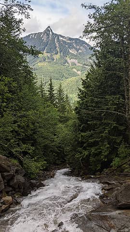
Calling this mountain a butte is a stretch, but so is calling McClellan a surveyor. Wait, was that the point?
The trail features two small switchbacks from here before it gets tired of those and just goes straight up to the ridge. "Wow, it would really suck to have to climb this without a trail" I thought to myself as it really sucked to climb it with a trail. There was some training weight in my pack. Here are some views from the steep ascent:
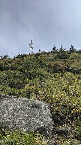
Looking up from the bottom of the ascent.
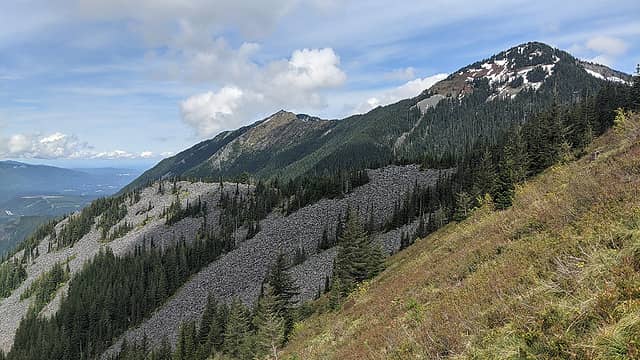
Defiance, PPP, Web.
Defiance, PPP, Web.
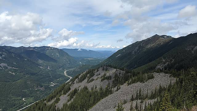
Seattle just peeking over Rattlesnake/Tiger.
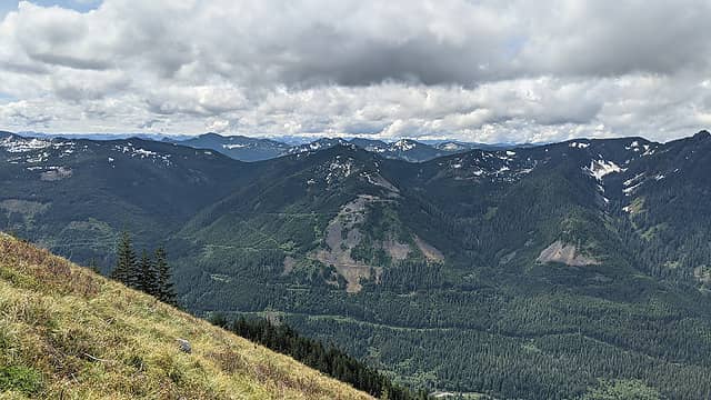
Gardner and some others. Anyone ascended that talus all the way from the Iron Horse? It's on my list.
Along the way up I had caught glimpses of people in shiny helmets along the ridge. When I got there, paragliders! Taking off requires sprinting headlong down the heather slopes shown above, so I was surprised he could stay aloft given what his balls must weigh. But he was soon flying free and being joined by his friends.
Snow is intermittent to the false summit, but getting pretty thin in places, so I stuck to rocks and dirt as much as possible. There were about a dozen people in that area, most watching the paragliding action. I lingered a bit, but thought I'd make an attempt at the true summit. The bootpath is easily followed to the SE, but soon becomes snow covered. I chatted with a couple guys who said they'd stopped at the snow and that they didn't think anyone else was beyond. Perfect! There were tracks to follow in places, but some of them were either made a while ago or by someone really foolish, because they are not in safe spots. Luckily, routefinding is pretty much taken care of by virtue of being on a ridge. I brought my axe and spikes but didn't end up using either; poles were sufficient. Near the summit it becomes a talus scramble; fortunately, enough snow had melted off to allow safe passage without risking breaking through a thin crust. Clouds had lifted and I had a great view of Rainier from the top, albeit a very windy one:
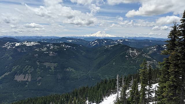
Some summits from a summit.
The "East Peak" has a surveyed elevation (5053), so naturally I set my sights on that next. Looking across Hi Valley, it seems quite close. Side note, Hi Valley is a really cool feature. Why does no one talk about this? Any geologists and/or historians on here who can comment on its origins/history? Anyway, the talus was interspersed with patches of snow that I knew would be thin, but I thought I spied a way through. Dropping my pack (and keeping a trekking pole in my pocket—why had I never thought of that before), I descended only to find a hidden patch of snow right where I needed one not to be. It might have been possible to find a more laborious way around or be super careful, but at that point I decided not to potentially ruin what had generally been a nice trip. I considered traversing along the ridge, but it looked like I might encounter more of the same. It'll probably go in a week or two. Nothing wrong with leaving an easy objective for next time. And I would like to explore Hi Valley more.
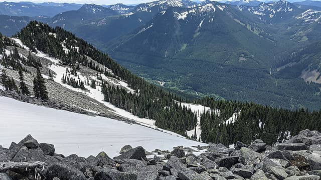
Looking into Hi Valley from west of the true summit.
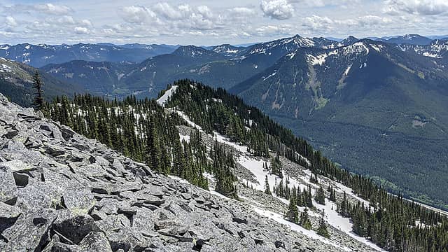
Looking towards the East Peak from below the true summit.
When I got back to my pack, one of the scariest things that's ever happened to me in the mountains occurred. Somehow I knocked my car keys out of my pack, and they began to slide down the flat boulder I was on towards certain oblivion in an inaccessible crevice. I managed to snag them in panic, but what would I have done if they'd fallen? Try to move the rocks out of the way? Anyone had this happen? Phew. Anyhow, I followed my own footprints back to the West Peak (except when I lost them a couple times, like how?), which I had to myself for a good fifteen minutes with perfect temperatures and excellent views all around.
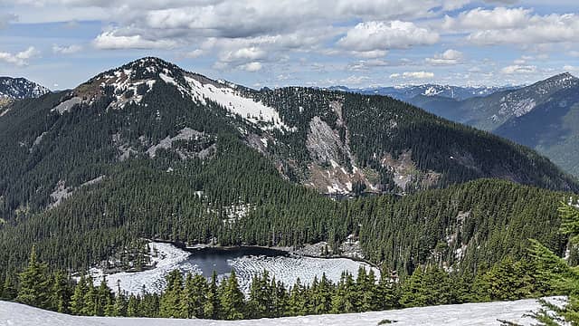
Defiance and Mason Lake from the West Peak.
On the way down, I passed a few people headed up the steep section. Then it was smooth sailing back to the trailhead at 4pm, where plenty of parking was now available. Pretty good early-ish-season trip! Felt legit to be blazing trail in spots on a relatively popular peak. And it was cool to start the trip with so many people and be the only one left at the high point.

"But [you] can't slow down now / As the earth has presented / A new crest to reach / Without barely a rest / From the last one"

Tom, reststep  KascadeFlat
Back to top Reply to topic Reply with quote Send private message
rossb
Member
Member


Joined: 23 Sep 2002
Posts: 1679 | TRs | Pics
rossb
Member
PostSun Jun 13, 2021 7:37 am 
I secure my keys on a loop, inside a compartment that doesn't get opened that often. In my old pack, I didn't have a loop, but I had two top compartments. One had stuff for the hike, the other only had keys and wallet (which meant it was only opened by the car). I think I may have learned that the hard way, although it has been so long that I don't remember.

achildinthesehills, dave allyn
Back to top Reply to topic Reply with quote Send private message
zephyr
aka friendly hiker


Joined: 21 Jun 2009
Posts: 3370 | TRs | Pics
Location: West Seattle
zephyr
aka friendly hiker
PostSun Jun 13, 2021 9:33 am 
rossb wrote:
I secure my keys on a loop, inside a compartment that doesn't get opened that often.
Definitely. You want to keep those items secure. And if I have driven anyone else to the trailhead with me, I let them know where the car keys are. ~z

Back to top Reply to topic Reply with quote Send private message
Joey
verrry senior member


Joined: 05 Jun 2005
Posts: 2798 | TRs | Pics
Location: Redmond
Joey
verrry senior member
PostSun Jun 13, 2021 4:52 pm 
Is your ride a 1990? Our F250 sure looks like a twin.

Back to top Reply to topic Reply with quote Send private message
achildinthesehills
Member
Member


Joined: 02 Jun 2021
Posts: 16 | TRs | Pics
Location: Tukwila, WA
achildinthesehills
Member
PostSun Jun 13, 2021 5:00 pm 
Joey wrote:
Is your ride a 1990?
It's a '97. Not my daily driver, but sure comes in handy for home/land improvement and unimproved roads!

"But [you] can't slow down now / As the earth has presented / A new crest to reach / Without barely a rest / From the last one"
Back to top Reply to topic Reply with quote Send private message
KascadeFlat
Member
Member


Joined: 06 Jul 2020
Posts: 318 | TRs | Pics
Location: Eating peanut M&Ms under my blue tarp
KascadeFlat
Member
PostMon Jun 14, 2021 8:42 pm 
Quote:
Regardless, if you have a low-clearance vehicle, make sure there's plenty of space in the trunk to stash all the undercarriage components that will certainly be liberated.
Low clearance + mountain road = liberation for oppressed oil pans. cool.gif

For a good time call: 1-800-SLD-ALDR.
Back to top Reply to topic Reply with quote Send private message
mosey
Member
Member


Joined: 18 Dec 2018
Posts: 163 | TRs | Pics
mosey
Member
PostSat Jun 19, 2021 2:07 pm 
KascadeFlat wrote:
Quote:
Regardless, if you have a low-clearance vehicle, make sure there's plenty of space in the trunk to stash all the undercarriage components that will certainly be liberated.
Low clearance + mountain road = liberation for oppressed oil pans. cool.gif
Unfortunate to hear. It was regraded/significantly repaired a few years ago as I recall.

Back to top Reply to topic Reply with quote Send private message
   All times are GMT - 8 Hours
 Reply to topic
Forum Index > Trip Reports > Bandera Mountain, 2021-06-12: West Peak, True Summit, attempt at East Peak
  Happy Birthday treasureblue, CascadeSportsCarClub, PYB78, nut lady!
Jump to:   
Search this topic:

You cannot post new topics in this forum
You cannot reply to topics in this forum
You cannot edit your posts in this forum
You cannot delete your posts in this forum
You cannot vote in polls in this forum