| Previous :: Next Topic |
| Author |
Message |
dcA2dc
Member


Joined: 11 Feb 2021
Posts: 9 | TRs | Pics
|
|
dcA2dc
Member
|
 Mon Jun 21, 2021 8:40 am |
|
|
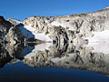
Climbed Mt. Aix this weekend (great conditions!) and saw a very distinct circle a couple ridges away to the southeast, on what looks like the east ridge of Rattlesnakes - looked almost like a crater in the hillside. Any idea what this was? Sinkhole? Mini-tornado blowdown? Alien landing?
Zoomed-in and zoomed-out photos:
Aerial shot from Caltopo (2013-2015) - looks like it's about 200 feet in diameter, between 5600-5800 elevation:
Location is on the north side of the ridge above the red trail that crosses the creeks at lower right:
|
| Back to top |
  
|
|
Anne Elk
BrontosaurusTheorist

Joined: 07 Sep 2018
Posts: 2423 | TRs | Pics
Location: Seattle |
|
Anne Elk
BrontosaurusTheorist
|
Mon Jun 21, 2021 9:12 am |
|
|
In the wide-angle photo, if you look to the right of the mystery circle, on the same slope, looks like there's a semi-circle formation, too. Like maybe the mother ship made a partial touchdown, to rescue the survivors and remove evidence. 
"There are yahoos out there. Its why we cant have nice things." - Tom Mahood
"There are yahoos out there. Its why we cant have nice things." - Tom Mahood
|
| Back to top |
|
|
daffish
Member

Joined: 16 Sep 2009
Posts: 282 | TRs | Pics
Location: Dreamtime |
|
daffish
Member
|
Mon Jun 21, 2021 10:56 am |
|
|
That could possibly be related to some experimental logging practices as uncovered in this thread:
Forest Dice
"Be moderate in everything, including moderation" Horace Porter
"Be moderate in everything, including moderation" Horace Porter
|
| Back to top |
|
|
Mike Collins
Member
Joined: 18 Dec 2001
Posts: 3097 | TRs | Pics
|
The landform shown is solidly within the William O. Douglas Wilderness area so it is unlikely to be a logging practice.
|
| Back to top |
|
|
Brushbuffalo
Member

Joined: 17 Sep 2015
Posts: 1887 | TRs | Pics
Location: there earlier, here now, somewhere later... Bellingham in between |
| daffish wrote: | | That could possibly be related to some experimental logging practices as uncovered in this thread:
Forest Dice |
A few years ago another reader asked me about that weird circle in the woods. I am quite sure that it is not geologic in form.
As Mike Collins points out, it is in wilderness. However, the William O. Douglas Wilderness was created in 1984. Is it possible that this is a pre-wilderness artifact?
Passing rocks and trees like they were standing still
Passing rocks and trees like they were standing still
|
| Back to top |
|
|
dcA2dc
Member
Joined: 11 Feb 2021
Posts: 9 | TRs | Pics
|
|
dcA2dc
Member
|
Tue Jun 22, 2021 5:11 pm |
|
|
That does seem possible. Maybe it was put in as the wilderness designation was pending to serve as a commemorative "O" for William O. Douglas.
Appreciate everyone's thoughts - guess I'll just have to head up and investigate next time I'm out there.
 Mike Collins Mike Collins
Mike Collins |
| Back to top |
|
|
rbuzby
Attention Surplus
Joined: 24 Feb 2009
Posts: 1011 | TRs | Pics
|
|
rbuzby
Attention Surplus
|
Tue Jul 27, 2021 2:04 pm |
|
|
There are holes drilled into the exposed bedrock at Heather pass (near Rainy Pass Hwy 20) and near Wing Lake. 2 in each spot, that I could see. I had a camera this time, so I shot one of them.
The sides of the interior of the holes are as smooth as glass (must have been a high quality drill bit). They are a few inches deep. The ones at Wing are far from any constructed trail. These aren't dynamite holes for trail building.
Test holes drilled by Geologists? By Brushbuffalo himself at the direction of Rowland Tabor, around 1972 maybe?
What do Geologists learn from these?
I noticed today that Rowland Tabor doesn't have a wiki entry. Someone familiar with him and his work should do one.
|
| Back to top |
|
|
RichP
Member

Joined: 13 Jul 2006
Posts: 5634 | TRs | Pics
Location: here |
|
RichP
Member
|
Tue Jul 27, 2021 2:09 pm |
|
|
rbuzby |
| Back to top |
|
|
Snowshovel
Member
Joined: 05 Apr 2021
Posts: 256 | TRs | Pics
|
| rbuzby wrote: | | There are holes drilled into the exposed bedrock at Heather pass (near Rainy Pass Hwy 20) and near Wing Lake. 2 in each spot, that I could see. I had a camera this time, so I shot one of them.
The sides of the interior of the holes are as smooth as glass (must have been a high quality drill bit). They are a few inches deep. The ones at Wing are far from any constructed trail. These aren't dynamite holes for trail building.
Test holes drilled by Geologists? By Brushbuffalo himself at the direction of Rowland Tabor, around 1972 maybe?
What do Geologists learn from these?
I noticed today that Rowland Tabor doesn't have a wiki entry. Someone familiar with him and his work should do one. |
Probably the work of paleomagnetists, most likely Myrl Beck and students
http://www.nickzentner.com/the-nick-zentner-geology-podcast/2020/9/6/48-myrl-beck-interview
rbuzby
rbuzby |
| Back to top |
|
|
RichP
Member
Joined: 13 Jul 2006
Posts: 5634 | TRs | Pics
Location: here |
|
RichP
Member
|
Mon Aug 16, 2021 5:58 pm |
|
|
Why do these rocks have almost rainbow colors? Seen near Gypsy Peak in Pend Oreille County.
|
| Back to top |
|
|
ejain
Member

Joined: 27 Apr 2009
Posts: 1498 | TRs | Pics
Location: Seattle, WA |
|
ejain
Member
|
Sun Feb 27, 2022 4:46 pm |
|
|
Interesting patterns on rocks near Lake Wanapum:
|
| Back to top |
|
|
Mike Collins
Member
Joined: 18 Dec 2001
Posts: 3097 | TRs | Pics
|
Found a nice piece of petrified wood in King County. I left it there but will keep the location private.
Now I Fly
Now I Fly |
| Back to top |
|
|
Tom
Admin
Joined: 15 Dec 2001
Posts: 17854 | TRs | Pics
|
|
Tom
Admin
|
Wed Aug 16, 2023 12:22 pm |
|
|
Brushbuffalo, curious about the striping on these rocks in the La Bohn Gap area. There were a lot of them (and lots of sparkly solid black ones as well, they just didn't photograph as well). Noticably heavy for their size, I assume they have iron or whatever they were mining for.
|
| Back to top |
|
|
Now I Fly
Member
Joined: 07 Jun 2018
Posts: 468 | TRs | Pics
|
Does anyone have an explanation for the pumice in the Mount Maude area.
I seem to recall reading that it came from a Glacier Peak eruption.?
Thanks, B
zimmertr
zimmertr |
| Back to top |
|
|
Bramble_Scramble
Member
Joined: 28 Dec 2012
Posts: 312 | TRs | Pics
|
| Tom wrote: | | Brushbuffalo, curious about the striping on these rocks in the La Bohn Gap area. There were a lot of them (and lots of sparkly solid black ones as well, they just didn't photograph as well). Noticably heavy for their size, I assume they have iron or whatever they were mining for. |
Tom I could be wrong but I think that's tourmaline. There's quite a bit in the area. There's even a peak in the area unofficially named Tourmaline Peak.
Also I don't think that's what they were mining. I'm noy sure if it really has any mineral value except to those that believe in crystal magic. The vein at Chain Lakes looks quite a bit different with a reddish color.
|
| Back to top |
|
|
|
|


