| Previous :: Next Topic |
| Author |
Message |
gb
Member


Joined: 01 Jul 2010
Posts: 6306 | TRs | Pics
|
|
gb
Member
|
 Sat Aug 21, 2021 7:50 am |
|
|
|
| Back to top |
  
|
|
yorknl
Member
Joined: 04 Aug 2008
Posts: 136 | TRs | Pics
|
|
yorknl
Member
|
Sat Aug 21, 2021 9:57 am |
|
|
For whatever it's worth, the current map (Saturday morning, 8/21) on the Inciweb site for the Schneider Springs fire shows the summit area of Mt. Aix outside the fire boundary, but not by much. It looks as though the fire is moving up the Dog Creek valley and it may not be a long wait for it to top Aix. Here's hoping it doesn't.
The same map also shows the fire boundary to now be on the west side of the Bumping River a mile or two downstream from Goose Prairie - sigh - albeit not yet over the road. Barring a miracle though it looks like that area will go up in smoke. Bah.
|
| Back to top |
|
|
RichP
Member

Joined: 13 Jul 2006
Posts: 5632 | TRs | Pics
Location: here |
|
RichP
Member
|
Sat Aug 21, 2021 10:37 am |
|
|
Here's a visual of Dog Ck.
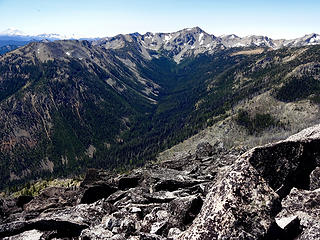 Dog Creek drainage and Mt Aix.
|
| Back to top |
|
|
gb
Member
Joined: 01 Jul 2010
Posts: 6306 | TRs | Pics
|
|
gb
Member
|
Sat Aug 21, 2021 4:00 pm |
|
|
Well, I just spoke with my friend who lives not far from Cliffdale and across the American River. He is Ok but the fire at Pinecliff got to within one mile of where he lives about a week ago. Currently, the fire is growing quite slowly and running out of fuel (already burnt, old burns, lava outcrops) in a number of areas.
It started in the Little Rattlesnake drainage, burnt down to the area near the concrete bridge on 1502, burnt up the slopes of Timberwolf Mountain, along Bethel Ridge, and much of the way up the Little Rattlesnake drainage, but has slowed or stopped in that direction. It burned Nelson Butte and up Dog Creek but stopped or slowed at an old burn (where an old trail came down off American Ridge) well up valley. It burnt over the top of Old Scab Mountain. It burned Buck Lake and up Lookout Creek but stopped in the upper creek where it becomes more open. As it started in the Little Rattlesnake drainage it burnt up the north slopes of Meeks Table. However, much of Meeks Table to the eastern side is scattered Ponderosa set in open grassy meadows - which could be hopeful. Also, it is hard to know what the fire intensity was or is as some areas are scattered Ponderosa and other areas are dense Lodgepole and Fir.
It has not burned the Richmond Mine Trail on the NW side of American Ridge nor to the crest in that area, and it has not burned across the Bumping River. The Bumping Lake trail up Aix is a bit of an unknown as the fire descended down to the Bumping River in places.
So, there is still hope. It is getting cooler and the nights longer, but really there is no rain in sight beyond what fell with yesterday's thunderstorms.
 RichP RichP
RichP |
| Back to top |
|
|
kbatku
Questionable hiker

Joined: 17 Sep 2007
Posts: 3330 | TRs | Pics
Location: Yaquima |
|
kbatku
Questionable hiker
|
Sat Aug 21, 2021 6:33 pm |
|
|
It's just below the crest of the mountains behind Rimrock Lake. The USFS* has shut down all the roads and campgrounds around Rimrock and on White Pass. This could get really really nasty
*edit from USAF lol
|
| Back to top |
|
|
Mountainfisherman
Member
Joined: 26 May 2010
Posts: 121 | TRs | Pics
|
American Ridge is west of the Bumping R and hasnt burned at all yet-wont unless or until it crosses the R. Spent a lot of time in my teens/early 20s between the North Fork of the Rattlesnake to Bethel R.
Lots of good memories-every one of my spots is burned over.
|
| Back to top |
|
|
Pyrites
Member
Joined: 16 Sep 2014
Posts: 1884 | TRs | Pics
Location: South Sound |
|
Pyrites
Member
|
Sat Aug 21, 2021 11:55 pm |
|
|
Is there confusion between evacuation maps and fire perimeter maps?
Keep Calm and Carry On?
Heck No.
Stay Excited and Get Outside!
Keep Calm and Carry On?
Heck No.
Stay Excited and Get Outside!
|
| Back to top |
|
|
Joey
verrry senior member

Joined: 05 Jun 2005
Posts: 2796 | TRs | Pics
Location: Redmond |
|
Joey
verrry senior member
|
Sun Aug 22, 2021 5:39 am |
|
|
Yesterday at 10pm there was an infrared (IR) flight over the Schneider Springs fire. The IR analyst determined that 67,534 acres have burned. If you want to see the USGS topo maps then change the basemap to "ESRI scanned topo USA". Mount Aix is still outside the perimeter.
View larger size in new window
dave allyn
dave allyn |
| Back to top |
|
|
Mountainfisherman
Member
Joined: 26 May 2010
Posts: 121 | TRs | Pics
|
Hi Joey-
I look forward to your posting of fire maps. I appreciate it. The northwestern corner where the fire is at the Bumping River and hopefully not over it is the closest that it is to American Ridge which separates the American R. drainage and the Bumping drainage. It appears, too, that it is moving into the upper reaches of the Wildcat Ck. drainage, towards Russell Ridge and Rimrock Lake. I am watching apprehensively as/if moves westward towards the Tumac Plateau-the flatish area west of Arneson/McNeil Peaks-many more of my 'spots' in there.  Thanks again.
Joey
Joey |
| Back to top |
|
|
MojaveGeek
Member
Joined: 16 Aug 2009
Posts: 49 | TRs | Pics
|
I watched the livestream report by the various specialists associated with the incident team yesterday. It sounded to me like the fire had crossed the Bumping River but the road was being held as a stronger fire line. I don't know what happened today. Looks like winds were from the east?
|
| Back to top |
|
|
treeswarper
Alleged Sockpuppet!
Joined: 25 Dec 2006
Posts: 11276 | TRs | Pics
Location: Don't move here |
|
treeswarper
Alleged Sockpuppet!
|
Tue Aug 24, 2021 4:00 pm |
|
|
Posted this in another thread, but part of the Tieton Side off Russell Ridge has had fuels reduction work in the recent past. Large areas were selectively logged and burned, and other areas had controlled burns with fire run through them. I hope it doesn't get tested, but it is there.
What's especially fun about sock puppets is that you can make each one unique and individual, so that they each have special characters. And they don't have to be humananimals and aliens are great possibilities
What's especially fun about sock puppets is that you can make each one unique and individual, so that they each have special characters. And they don't have to be humananimals and aliens are great possibilities
|
| Back to top |
|
|
fourteen410
Member

Joined: 23 May 2008
Posts: 2628 | TRs | Pics
|
Aerial recon flight from yesterday if anyone is looking for a visual:
geyer
geyer |
| Back to top |
|
|
treeswarper
Alleged Sockpuppet!
Joined: 25 Dec 2006
Posts: 11276 | TRs | Pics
Location: Don't move here |
|
treeswarper
Alleged Sockpuppet!
|
Thu Aug 26, 2021 8:21 pm |
|
|
Thanks for posting the video, even though it made me sad.
That area used to be referred to as an asbestos forest.
What's especially fun about sock puppets is that you can make each one unique and individual, so that they each have special characters. And they don't have to be humananimals and aliens are great possibilities
What's especially fun about sock puppets is that you can make each one unique and individual, so that they each have special characters. And they don't have to be humananimals and aliens are great possibilities
|
| Back to top |
|
|
zephyr
aka friendly hiker

Joined: 21 Jun 2009
Posts: 3370 | TRs | Pics
Location: West Seattle |
|
zephyr
aka friendly hiker
|
Thu Aug 26, 2021 8:58 pm |
|
|
| fourteen410 wrote: | | Aerial recon flight from yesterday if anyone is looking for a visual: |
Thank you for posting that video. It was fascinating. I have never been in that country before. The forest is beautiful around that helibase area. I felt like I learned a little something about fire science in the process. ~z
|
| Back to top |
|
|
MojaveGeek
Member
Joined: 16 Aug 2009
Posts: 49 | TRs | Pics
|
I listened to the incident team's Zoom last night. Apparently on Tuesday-ish the fire managed to leap across the Bumping River and the road, and is now burning up on American Ridge. I think no structures were damaged, but that fire line was there to protect structures, and I didn't hear of much of a plan to fight the fire as it goes up the ridge, though there is less fuel at the top of the ridge From the perspective of hiking potential, this is a big blow which could threaten the PCT. Most of the talk is about protecting structures, right now pressure in the north east as 410 makes the big turn to the south. Mt. Rainier webcams today show a lot of smoke to the east.
|
| Back to top |
|
|
|
|


