| Previous :: Next Topic |
| Author |
Message |
neek
Member


Joined: 12 Sep 2011
Posts: 2337 | TRs | Pics
Location: Seattle, WA |
|
neek
Member
|
 Mon Aug 16, 2021 5:51 pm |
|
|
Dave and I headed to Mowich Lake Sunday morning to hike Observation and Echo Rock. We hit a few smaller peaks on the way back and went part way up Ptarmigan Ridge to get as close to Rainier as possible. Nearly everything was on trail or bootpath, with a few minor scramble sections. We wore boots, but someone willing to get their feet wet in slushy snow could probably get by with shoes and microspikes.
The road to Mowich Campground is long and washboard-y, but low clearance wouldn't be a problem. Parking wasn't as issue, although we arrived fairly early. Bugs were only an annoyance in a couple of places. People were surprisingly sparse. Flowers are still out, but waning.
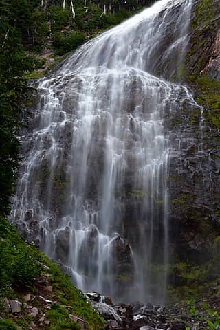
We started up the Spray Park trail, taking the short side trip to the impressive Spray Falls. Soon we reached the well-worn path to Observation/Echo, crossing a few snow fields and finally the soggy glacier to reach the base of Echo. I found the volcanic rubble to be slightly more stable than typical Cascades choss, probably because of how rough the surface is. Echo has an obvious path to the summit with a short scramble section. The rock is delightfully red, and we were glad to find that smoke wasn't obscuring our views, maybe even enhancing them.
Observation Rock is even easier since there's a trail all the way. We heard a lot of rockfall on Rainier and saw huge dust clouds rising up. Rainier is really awe-inspiring from this side. After lunch and a nap on Observation, we walked up Ptarmigan Ridge a little bit to get even closer. We noticed some yellow object sticking out of the Russell Glacier, which a zoom shot revealed to be probably a tent that had blown away in the wind. Unfortunately it wouldn't have been safe to retrieve without proper glacier gear.
It was hard to leave the area, but we eventually turned our backs to the mountain and retraced our steps to the Spray trail. Wanting to make a loop, we soon turned right on the Knapsack Pass trail/path, which also provided the opportunity to climb a few more peaks. First up was Mount Pleasant, with a quick jaunt over to Hessong Rock. Trail pretty much all the way. Delicious blueberries between the two peaks slowed us down. From Pleasant we dropped back down to the Knapsack trail and ran into a family of 4 who had heard the trail looped back to Mowich but seemed pretty nervous about it. I explained the route to them and assured them it would go. They were moving very slowly and we quickly left them behind, hoping they wouldn't have trouble where the trail, as it turns out, disappears into scree.
From Knapsack Pass we tackled First Mother, which looks pretty gnarly when you see what the actual summit looks like, but which has a trail up the easy (if steep) side. Then it was back to the pass, down a little, and up the very steep path to East Fay. From there we planned to traverse to the main Fay peak (which somehow is not quite as tall as East Fay), and found there to be a trail here as well. About half way we crossed from the north to the south side through a fun little notch. Right before that we saw the party of 4 reach Knapsack Pass, which was a relief.
From Fay, there was some easy scrambling off the west side, then a mile of trail back to the car. A perfect day in one of the country's best national parks. About 17 mi with 7200' of gain. Thanks Dave!
 Spray Falls 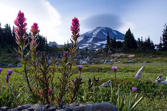 Spray Park 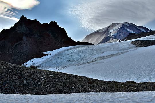 Flett Glacier 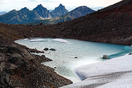 Sluiskin and Old D 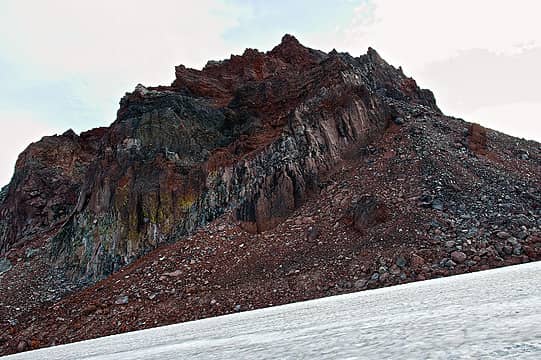 Echo Rock 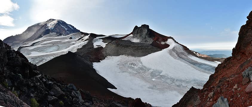 Rainier and Observation from Echo 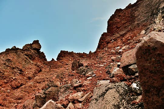 Heading up Echo 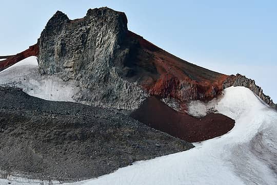 Observation Rock 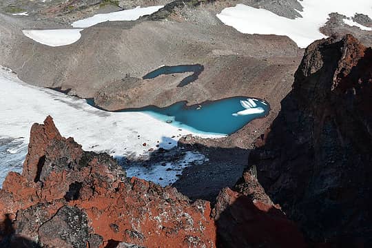 Looking down from Echo 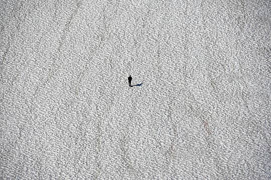 Lone hiker heading up snow 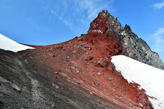 Observation 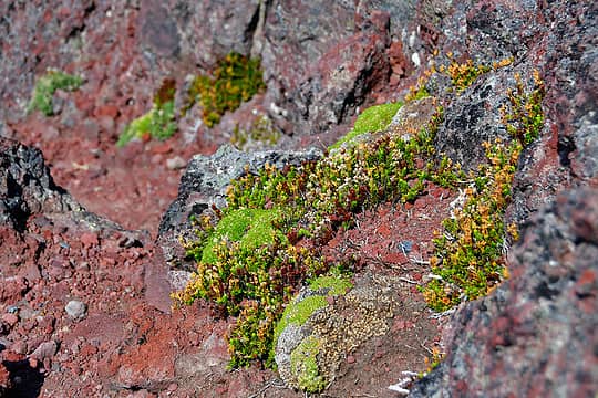 Volcanic garden 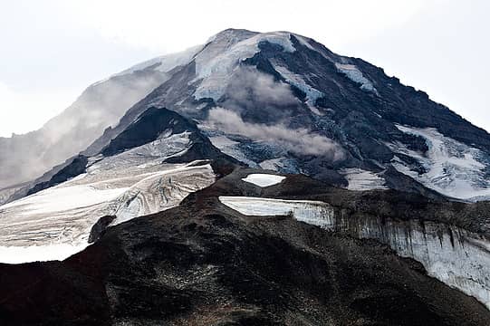 Huge dust clouds from rockfall 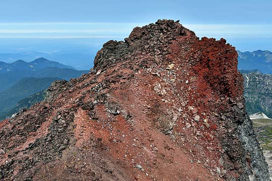 Trail to Observation summit 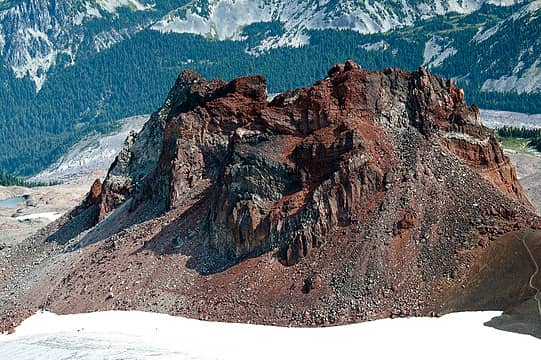 Echo from Observation 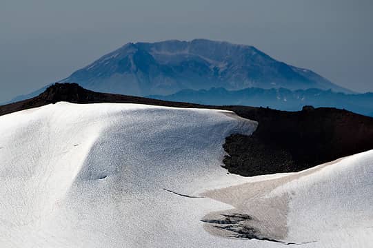 St. Helens 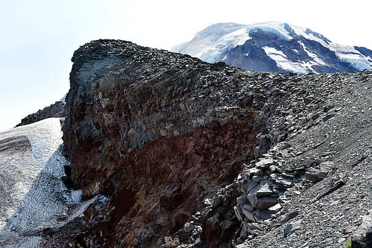 Our perch on Ptarmigan Ridge 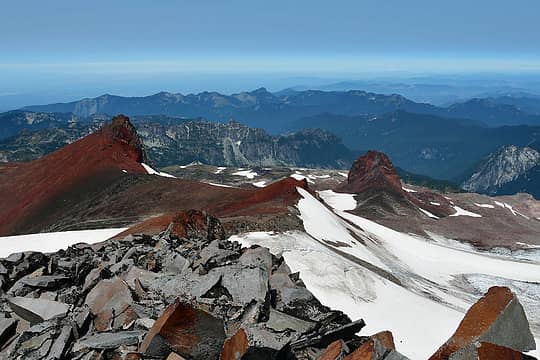 Looking back at Observation and Echo Rocks from Ptarmigan Ridge 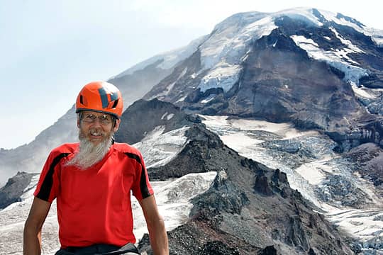 Yes it's windy 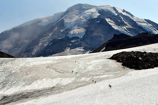 Ice climbing group returning 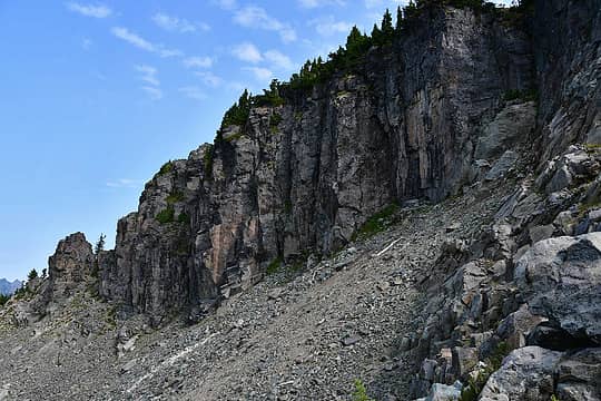 North side of Hessong Rock 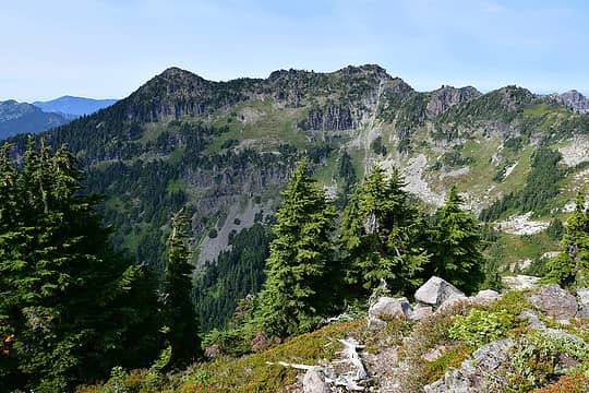 Fay Peak 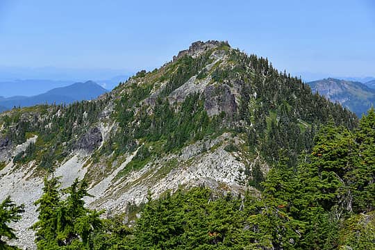 Mount Pleasant 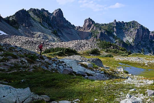 Heading to Knapsack Pass 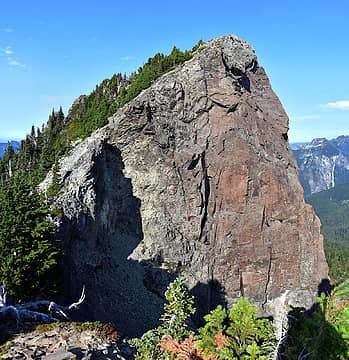 First Mother 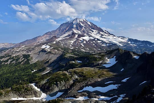 Rainier postcard 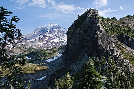 Looking across Knapsack Pass 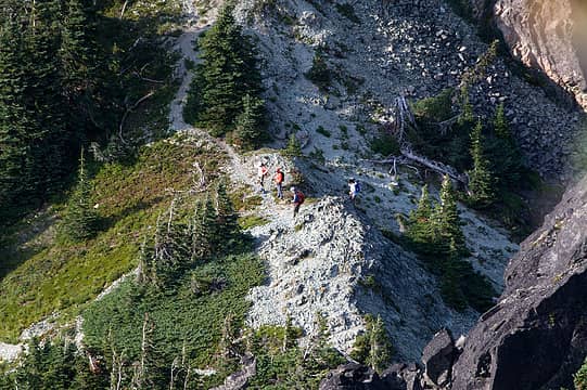 Party of 4 reaches the pass 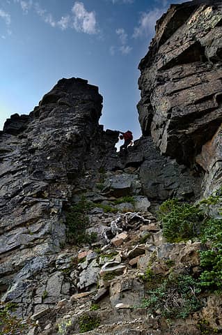 Crossing to S side of Fay to complete traverse 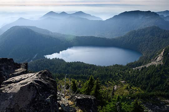 Mowich Lake 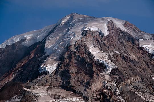 Rainier zoom  Cones 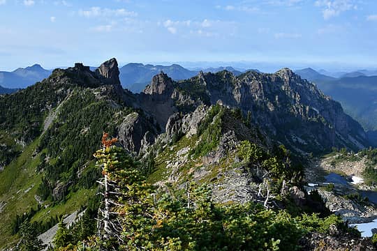 Mother 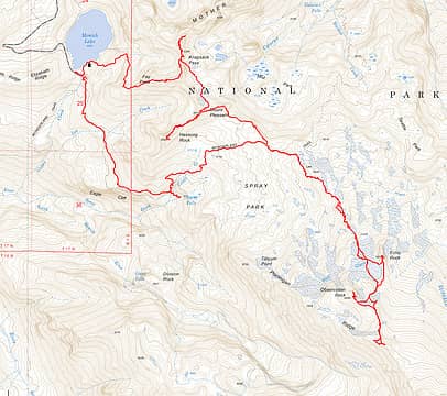 route
 Popcorn, valleyjo, reststep, Brushbuffalo, Schroder, abkoch3, Cyclopath, Route Loser, hapemask, olderthanIusedtobe, jaysway, flatsqwerl, RichP, awilsondc, Pef, ozzy, zimmertr, Tom, raising3hikers Popcorn, valleyjo, reststep, Brushbuffalo, Schroder, abkoch3, Cyclopath, Route Loser, hapemask, olderthanIusedtobe, jaysway, flatsqwerl, RichP, awilsondc, Pef, ozzy, zimmertr, Tom, raising3hikers
Popcorn, valleyjo, reststep, Brushbuffalo, Schroder, abkoch3, Cyclopath, Route Loser, hapemask, olderthanIusedtobe, jaysway, flatsqwerl, RichP, awilsondc, Pef, ozzy, zimmertr, Tom, raising3hikers |
| Back to top |
  
|
|
williswall
poser

Joined: 30 Sep 2007
Posts: 1967 | TRs | Pics
Location: Redmond |
Thats a lot of peaks for 1 day, nice job!
|
| Back to top |
|
|
puzzlr
Mid Fork Rocks

Joined: 13 Feb 2007
Posts: 7220 | TRs | Pics
Location: Stuck in the middle |
|
puzzlr
Mid Fork Rocks
|
Mon Aug 16, 2021 11:18 pm |
|
|
Awesome zoom you've got there. St Helens is a long ways away! A long time ago we did all those except First Mother but split them into two days (in so-so weather). Is it always windy in Observation Point? We could hardly stand up there.
|
| Back to top |
|
|
ozzy
The hard way

Joined: 30 Jul 2015
Posts: 476 | TRs | Pics
Location: University place, wa |
|
ozzy
The hard way
|
Tue Aug 17, 2021 5:32 am |
|
|
I dont know whats gonna happen, but I wanna have my kicks before the whole shithouse goes up in flames-Mr Mojo Risin
|
| Back to top |
|
|
BarbE
Member

Joined: 28 Jul 2006
Posts: 1153 | TRs | Pics
|
|
BarbE
Member
|
Tue Aug 17, 2021 12:35 pm |
|
|
Day hike and 6 summits on the Mountaineer 100 Rainier list, plus stellar photography! Impressive!
|
| Back to top |
|
|
Fletcher
Member

Joined: 29 Jul 2009
Posts: 1870 | TRs | Pics
Location: kirkland |
|
Fletcher
Member
|
Fri Aug 20, 2021 9:50 pm |
|
|
Some very quality pics of Scoutmaster Dave in this post!!
|
| Back to top |
|
|
zephyr
aka friendly hiker

Joined: 21 Jun 2009
Posts: 3370 | TRs | Pics
Location: West Seattle |
|
zephyr
aka friendly hiker
|
Fri Aug 20, 2021 10:00 pm |
|
|
Missed seeing your report earlier for some reason. What a hike! Some truly amazing photos in this collection. Those reds at Observation Rock and Echo Rock are something else. I need to get up there. I have been to Fay Peak at least. That's just the front door.
This one is quite evocative.
Wondering what waterfall this might be? Not sure your direction at this point. Could it be Cataract Falls? ~z
|
| Back to top |
|
|
neek
Member
Joined: 12 Sep 2011
Posts: 2337 | TRs | Pics
Location: Seattle, WA |
|
neek
Member
|
Sat Aug 21, 2021 6:30 am |
|
|
| Fletcher wrote: | | Some very quality pics of Scoutmaster Dave in this post!! |
I meant to thank Dave for extreme patience while I attempted to get some good portraits! I hate getting my picture taken...
| zephyr wrote: | | Wondering what waterfall this might be? Not sure your direction at this point. Could it be Cataract Falls? |
Thanks, z. Good question. It (and several others) are visible in one of the panoramas:
I'd guess the unnamed one at 46.890555, -121.825358 coming out of the North Mowich Glacier.
|
| Back to top |
|
|
zephyr
aka friendly hiker
Joined: 21 Jun 2009
Posts: 3370 | TRs | Pics
Location: West Seattle |
|
zephyr
aka friendly hiker
|
Sat Aug 21, 2021 11:09 am |
|
|
| neek wrote: | | Thanks, z. Good question. It (and several others) are visible in one of the panoramas: |
Yes, I did also see it in your panorama. I was wondering where you were standing at that point? I looked back through my photos of a Fay Peak trip in 2015. I have photos of similar waterfalls over that way coming off the mountain. They were impressive from a distance and I have been trying to figure out which ones they were ever since. As you suggest they may be unnamed. Do you think you were still on Ptarmigan Ridge or more north near Knapsack Pass? Thanks again.
Also when reviewing my photos I remembered how the south aspect of the Fay Peak ridge was rather unstable. Lots of loose rock on the upper ridge and we had to pass beneath a tall gendarme that looked as if it could tumble over at any moment. Not to mention the enormous house-sized boulder sitting in the wings at Knapsack Pass just waiting to let loose and roll through the valley toward Mowich.  At least that's how it seemed to me. I didn't mention it to my partner at the time who was already sketched out from a bit of exposure on the climb up. haha I just had to keep him moving along. ~z At least that's how it seemed to me. I didn't mention it to my partner at the time who was already sketched out from a bit of exposure on the climb up. haha I just had to keep him moving along. ~z
|
| Back to top |
|
|
Schroder
Member

Joined: 26 Oct 2007
Posts: 6722 | TRs | Pics
Location: on the beach |
|
Schroder
Member
|
Sat Aug 21, 2021 11:40 am |
|
|
 That used to be a Peak Pin group with the Mountaineers if you also did Mother Mtn That used to be a Peak Pin group with the Mountaineers if you also did Mother Mtn
|
| Back to top |
|
|
neek
Member
Joined: 12 Sep 2011
Posts: 2337 | TRs | Pics
Location: Seattle, WA |
|
neek
Member
|
Sat Aug 21, 2021 12:28 pm |
|
|
| zephyr wrote: | | Do you think you were still on Ptarmigan Ridge or more north near Knapsack Pass? |
Waterfall photo was taken from 46.89424N, 121.80015W, up on the ridge.
Here's a shot from Fay Peak, where you can see some of these falls (with Hessong Rock in front).
...oh and from Hessong too, why not.
|
| Back to top |
|
|
zephyr
aka friendly hiker
Joined: 21 Jun 2009
Posts: 3370 | TRs | Pics
Location: West Seattle |
|
zephyr
aka friendly hiker
|
Sat Aug 21, 2021 1:09 pm |
|
|
| neek wrote: | | Here's a shot from Fay Peak, where you can see some of these falls (with Hessong Rock in front). |
Yes! That's it--that first of the two photos. That's the waterfall that I spotted from Fay Peak. The tall one in the center just behind Hessong Rock. It matches my photo. It drops a long ways. Thanks, ~z
neek
neek |
| Back to top |
|
|
Gregor
Gregor

Joined: 15 May 2007
Posts: 117 | TRs | Pics
|
|
Gregor
Gregor
|
Sun Aug 22, 2021 8:51 am |
|
|
Great pictures! Obs rock looks so different than I remember from 15 years ago.
|
| Back to top |
|
|
|
|
You cannot post new topics in this forum
You cannot reply to topics in this forum
You cannot edit your posts in this forum
You cannot delete your posts in this forum
You cannot vote in polls in this forum
|
Disclosure: As an Amazon Associate NWHikers.net earns from qualifying purchases when you use our link(s). |


 It's always nice to have a reason to go back there. Sweet trip guys!


