| Previous :: Next Topic |
| Author |
Message |
neek
Member


Joined: 12 Sep 2011
Posts: 2337 | TRs | Pics
Location: Seattle, WA |
|
neek
Member
|
 Mon Sep 08, 2014 3:33 pm |
|
|
This report describes a 3-day loop I did Sept. 5-7: Spider Meadow - Spider Gap - Lyman Lakes - Cloudy Peak - Cloudy Pass - Suiattle Pass - Miners Ridge - Image Lake - Suiattle River - Middle Ridge - Buck Pass - Fortress Mountain - Buck Creek Trail
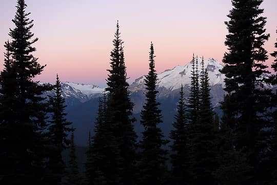 Glacier Peak from Middle Ridge, Sunday morning. One of the last gasps from my camera battery. 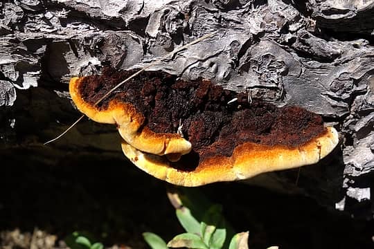 Shelf fungus growing on a fallen log in Spider Meadow. Around this time I found a fairly large spider crawling on me. Maybe that is how the meadow got its name! 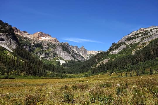 Here's what Spider Meadow looks like, if for some reason you've never been there 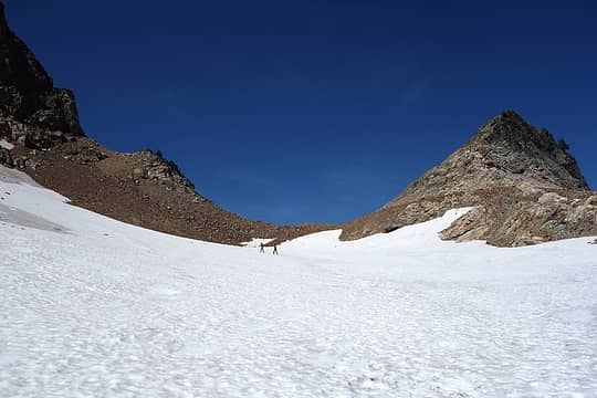 Couple guys heading West from the gap. They sent down some huge rocks a few minutes later - hope they weren't seriously trying to get up the east arm of Chiwawa 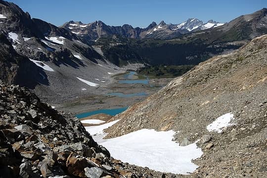 Upper Lyman Lakes and the incredible scenery that awaits on the other side of the gap 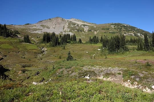 Cloudy Peak 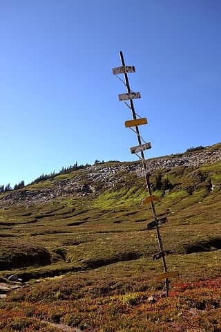 What the heck is this thing? 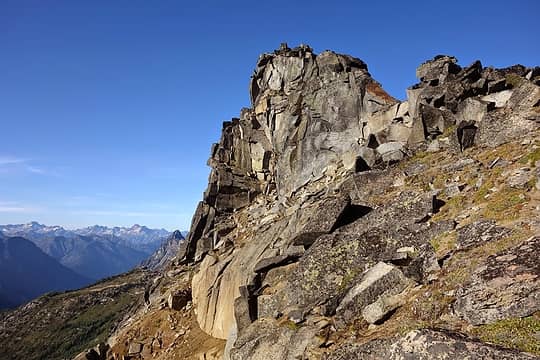 Easy summit scramble 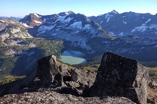 Summit view down to Lower Lyman Lake, backed by Red, Chiwawa, and Fortress 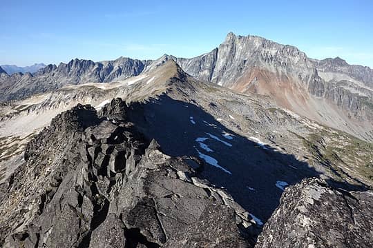 Not feasible to run the ridge to North Star, you'd have to drop down a bit. Bonanza in the back. 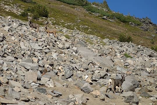 3 bucks (they blend in really well against the rocks), the most interesting wildlife spotting on the trip 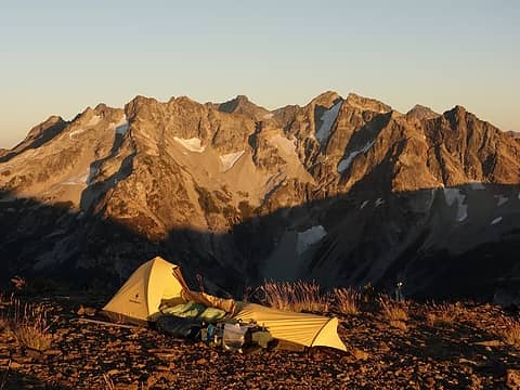 Perfect bivy site 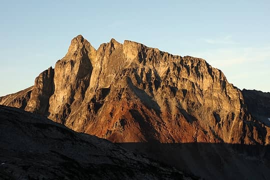 Bonanza 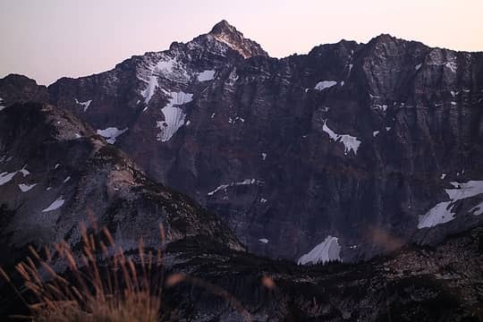 Fresh snow on Fortress 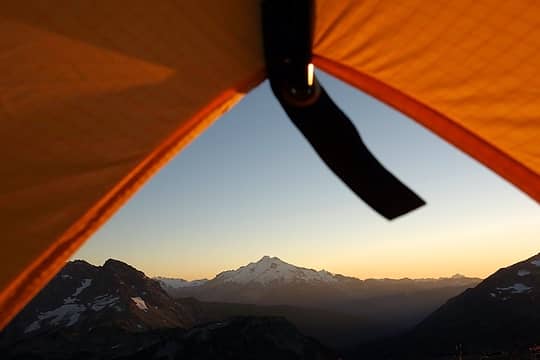 Room with a view 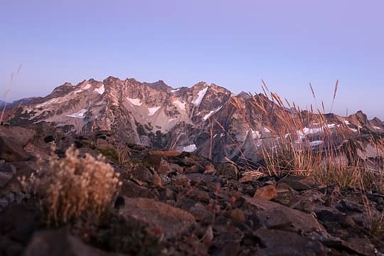 2-second exposure with camera sitting on rock 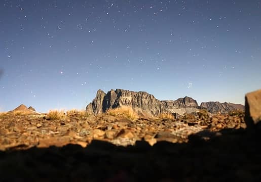 Night shot (almost a full moon). Best I could do with my point-and-shoot camera. 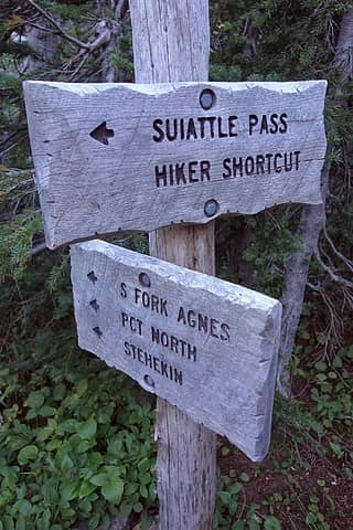 If it's official, how can it be a shortcut? 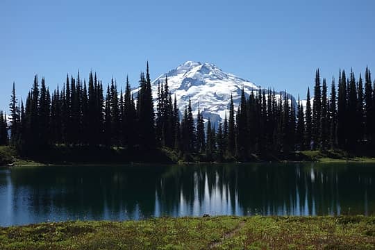 I've seen this classic shot so many times it was kind of surreal to finally be there in person 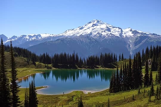 See the guy and his dog? 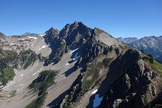 Plummer Mountain. Beckey says it's "in an area of little mountaineering interest" but I bet the view is great. 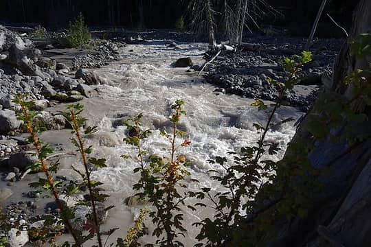 Suiattle River, very close to the washed-out PCT bridge 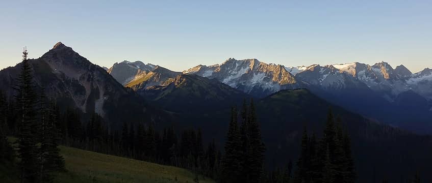 Foreground: Helmet Butte, Rally Cap, Liberty Cap, Flower Dome. Background: mountains
 Randito, Sculpin, Bowregard Randito, Sculpin, Bowregard
Randito, Sculpin, Bowregard |
| Back to top |
  
|
|
cartman
Member

Joined: 20 Feb 2007
Posts: 2800 | TRs | Pics
Location: Fremont |
|
cartman
Member
|
Mon Sep 08, 2014 5:58 pm |
|
|
That's one fine trip and a lot of moving over three days. Glad you got out and saw the area--one of my all-time favorites.
|
| Back to top |
|
|
reimember
Member
Joined: 22 Aug 2014
Posts: 15 | TRs | Pics
|
|
| Back to top |
|
|
User-Name
Member

Joined: 10 Aug 2010
Posts: 312 | TRs | Pics
Location: bellevue |
|
| Back to top |
|
|
Magellan
Brutally Handsome

Joined: 26 Jul 2006
Posts: 13116 | TRs | Pics
Location: Inexorable descent |
|
Magellan
Brutally Handsome
|
Tue Sep 16, 2014 8:42 pm |
|
|
Those are three pretty big days in a row. Gorgeous photos. 
|
| Back to top |
|
|
marydave
Musical Hikers
Joined: 11 Aug 2010
Posts: 182 | TRs | Pics
Location: Seattle |
|
marydave
Musical Hikers
|
Tue Sep 16, 2014 8:52 pm |
|
|
Nice work . Impressive mileage and vertical in three days, and with time to take beautiful pictures. I've wanted to camp at Middle Ridge; guess I'll have to revisit the area.
|
| Back to top |
|
|
Brushbuffalo
Member

Joined: 17 Sep 2015
Posts: 1887 | TRs | Pics
Location: there earlier, here now, somewhere later... Bellingham in between |
| neek wrote: | What the heck is this thing? |
I'm obviously a few thousand days late to this party, but I don't see a response in this thread.
As you no doubt know by now, Neek, this weird-looking contraption is a snow stake. A surveyor can take a look, usually from the air in remote locales, and determine snow depth based on how many of the crossbars are showing above the snow surface.
Passing rocks and trees like they were standing still
Passing rocks and trees like they were standing still
|
| Back to top |
|
|
pula58
Member
Joined: 13 Aug 2009
Posts: 589 | TRs | Pics
|
|
pula58
Member
|
Tue Sep 07, 2021 10:38 am |
|
|
I think the avalanches got the best of the snow-depth pole!
|
| Back to top |
|
|
Bowregard
Member
Joined: 05 Feb 2019
Posts: 562 | TRs | Pics
Location: Sammamish |
Great photos neek,
I didn't catch the explanation for "The feeling of smugness by saving a few hundred feet of walking would come back to haunt me on the return!", perhaps a reference to having to pass parked cars to get to yours? (I was afraid something happened to your car). It's funny how long those last steps can seem sometimes. That was a lot for 3 days.
I would have missed out on 2 bucks if you hadn't pointed out how well camouflaged they were (only saw the middle one on first glance).
Sounds like a great trip!
|
| Back to top |
|
|
timberghost
Member
Joined: 06 Dec 2011
Posts: 1330 | TRs | Pics
|
Yea high hunters will be in some of that area next week.
|
| Back to top |
|
|
Kim Brown
Member
Joined: 13 Jul 2009
Posts: 6899 | TRs | Pics
|
The Miner's Ridge LO got a lot of work done on it this summer; new roof, paint, and other stuff (pics on MBS's Facebook page). Were any volunteers up there working on it when you were there?
"..living on the east side of the Sierra world be ideal - except for harsher winters and the chance of apocalyptic fires burning the whole area."
Bosterson, NWHiker's marketing expert
"..living on the east side of the Sierra world be ideal - except for harsher winters and the chance of apocalyptic fires burning the whole area."
Bosterson, NWHiker's marketing expert
|
| Back to top |
|
|
Tom
Admin
Joined: 15 Dec 2001
Posts: 17854 | TRs | Pics
|
|
Tom
Admin
|
Wed Sep 08, 2021 10:49 am |
|
|
This TR is from 2014, FYI.
 Obi Tony Kenobi Obi Tony Kenobi
Obi Tony Kenobi |
| Back to top |
|
|
Kim Brown
Member
Joined: 13 Jul 2009
Posts: 6899 | TRs | Pics
|
| neek wrote: | | This is how I love ending a long hike though - physically depleted, but mentally refreshed enough to re-join civilization. |
Opposite for me; I don't even want to listen music in the car on the way home. No news, no radio. Sometimes for days afterwards. No participation in office meetings; I just sit there and wipe my mouth with my sleeve and burp out loud. I might show off a scab or a bruise.
I will go to a restaurant after a trip to grub out, though; hell I ain't totally crazy.
"..living on the east side of the Sierra world be ideal - except for harsher winters and the chance of apocalyptic fires burning the whole area."
Bosterson, NWHiker's marketing expert
"..living on the east side of the Sierra world be ideal - except for harsher winters and the chance of apocalyptic fires burning the whole area."
Bosterson, NWHiker's marketing expert
|
| Back to top |
|
|
Kim Brown
Member
Joined: 13 Jul 2009
Posts: 6899 | TRs | Pics
|
| Tom wrote: | | This TR is from 2014, FYI. |
Ah! I Didn't notice that. Thanks. Still, it's enjoyable as hell.
"..living on the east side of the Sierra world be ideal - except for harsher winters and the chance of apocalyptic fires burning the whole area."
Bosterson, NWHiker's marketing expert
"..living on the east side of the Sierra world be ideal - except for harsher winters and the chance of apocalyptic fires burning the whole area."
Bosterson, NWHiker's marketing expert
|
| Back to top |
|
|
Bowregard
Member
Joined: 05 Feb 2019
Posts: 562 | TRs | Pics
Location: Sammamish |
That was my fault. I didn't catch that the recent post was about how the pole was bent or the OP date.
One of these days I will get used to the idea of checking the OP date and notice the poster's names.
Thanks Tom
|
| Back to top |
|
|
|
|
You cannot post new topics in this forum
You cannot reply to topics in this forum
You cannot edit your posts in this forum
You cannot delete your posts in this forum
You cannot vote in polls in this forum
|
Disclosure: As an Amazon Associate NWHikers.net earns from qualifying purchases when you use our link(s). |


