Forum Index > Trip Reports > Tieton, Ives, Old Snowy, Devils Horns, Bear Creek Mtn, Oct 16, 2021
 Reply to topic
Previous :: Next Topic
Author Message
Eric Gilbertson
Member
Member


Joined: 04 Jul 2018
Posts: 188 | TRs | Pics
Location: Seattle
Eric Gilbertson
Member
PostMon Oct 18, 2021 8:55 pm 
Tieton (7,768ft), Ives (7,920ft), Old Snowy (7,880ft), Devils Horns (7,040ft), Bear Creek Mtn (7,337ft) Eric Gilbertson 26 miles, 10,500ft gain Oct 16, 3:30am – 6:30pm Southern Washington looked like it had some of the driest weather forecast for Saturday so I decided to climb a bunch of 7,000ft peaks in the Goat Rocks wilderness. I’d already climbed Gilbert and Goat Citadel in late November 2019, but there were quite a few other interesting peaks in the area. I was intrigued by the idea of making a big above treeline loop to hit six peaks. I’d read that Eric E and Dustin W had hiked the ridge from Bear Creek Mtn to Tieton, and I saw a trail went from Old Snowy north all the way to the Scatter Creek trailhead on the north side of the wilderness. I’d also read Selena and Jake had traversed from Old Snowy to Big Horn on the ridge. If I could just link the ridge from Tieton to the ridge near Big Horn then I could make a big 26-mile loop from Scatter Creek, with over half the loop being ridge runs above treeline. The terrain looked doable on the topo map, so I decided to give it a try. Worst case if I got cliffed out I could always bail down to the North Fork Tieton River and bushwhack back to the trailhead.
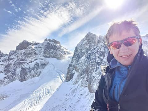
Looking back at the Tieton Glacier below Goat Citadel
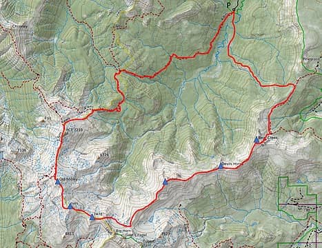
The route
The route
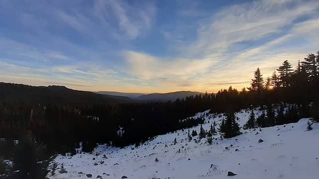
Sunrise near Pinegrass Ridge
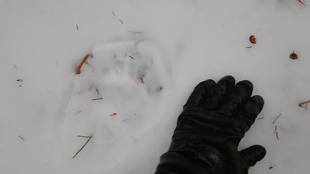
NOHRSC was showing a decent amount of snow above treeline in the area, so I decided to go in hiking boots with micro spikes, gatiers, and my whippet. I slept at the scatter creek trailhead Friday night and was moving by 3:30am Saturday morning. The quad showed trail 1128 going up to Pinegrass Ridge, but apparantly the trail has been abandoned for a while. The trail started out in good shape along the north fork tieton river, but got hard to follow once it started ascending the slopes to the east. I think the darkness didn’t help with nagivation. I generally followed the trail, but sometimes lost it in all the blowdowns, and lost it for good once snowline started at 6,000ft. By sunrise I emerged on the ridge south of Pinegrass Ridge Peak and followed the ridge south. The terrain was open enough that I didn’t bother trying to find the trail 1130 just below the ridge. I stumbled across some fresh mountain lion tracks in the snow, and followed them to a craggy area of the ridge. Here it made more sense to go follow the trail.
Big cat tracks
Big cat tracks
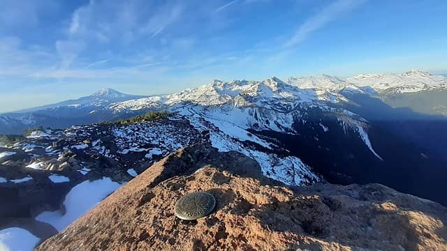
Bear Creek Mountain looking towards Tieton, Gilbert, and Ives
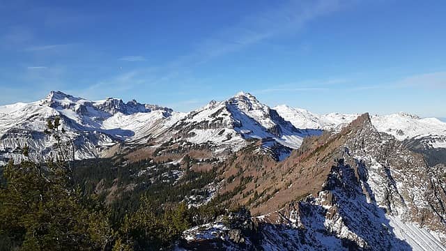
Approaching Deviles Horns
I dropped a bit and found some boot prints in the snow on the trail. This would certainly help with trail breaking and navigation. I followed the trail all the way to Bear Creek Mountain by 8am and stopped to admire the view. Rainier, Adams, and St Helens were all clearly visible in the nice sunny weather. This would be the last trail for me for much of the day. I continued south along the ridge, mostly staying on the crest but occasionally dropping to the southeast to get around cliffs. I soon came to the base of Devils Horns, an interesting set of rock spires that rise a bit above 7,000ft. Unfortunately I hadn’t done any research on this peak and assumed it would be easy, but it appeared intimidating. I got closer, following the east ridge, and the SE face didn’t look too bad. There was a sort of gully with a lower angle face on the right with a bunch of knobby holds. I should have packed my poles but ended up scrambling up carefully while holding them, and quickly reached the top. I think it was probably 4th class.
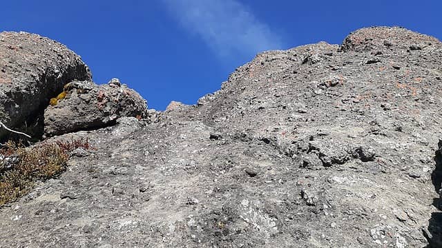
The short scramble up Devils Horns
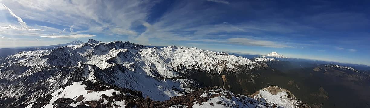
The view from Tieton
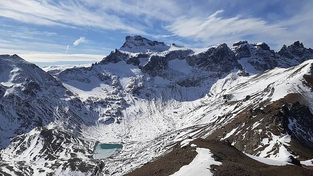
At the top I saw an easier descent on the west face, which was low angle enough to kind of crab walk down facing out. I guess that could be considered class 3+, and probably a bit easier than the SE face, though a fall there would still be unadvisable. The ridge looked very saw-toothed from there, so I dropped straight south down a chossy gully and traversed below all the cliffs to regain the ridge. I continued along the ridge to a cliff band just below the Tieton massif and stopped there to fill up water. The east facing snowfields were melting in the morning sun and the drip rate was just fast enough for me to wait to fill up my 2L bladder. I then kicked steps up deep snow to the ridge and followed the ridge to the summit around 11am. Awesome views opened up in front of me to Gilbert, Goat Citadel, and the Ives-Old-Snowy ridge I planned to follow. It looked very snowy, and I was a bit worried about my postholing speed. The previous ridge run had gone slower than I’d hoped, and I was hoping to get home at a reasonable hour that night. I cursed myself for not starting earlier that morning, but resolved to be more efficient and minimize breaks for the remainder of the day to stay on schedule.
Approaching Gilbert
Approaching Gilbert
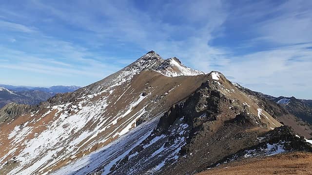
Looking back at Tieton with much less snow on south faces
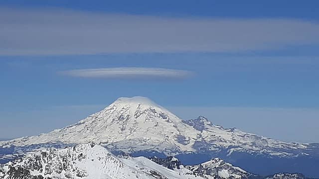
Lenticular cloud forming on Rainier
I followed the ridge down southwest, which had some fun scrambling sections on snowy knife-edge rocks. It eventually turned into easy walking on scree and snowfields. I took a short break atop point 7386 and had great views across the Tieton Glacier up to Goat Citadel and Big Horn. The glacier looked much smaller than is shown on the quad, and it looked reasonable for me to traverse below it, then climb up a snow slope to gain the ridge near Ives. It appeared my loop might work after all.
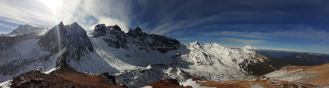
Approaching my traverse below Goat Citadel and Big Horn
I descended to the glacier, then started traversing. Unfortunately I had broken my microspike on one foot earlier in the day and it wasn’t very effective. So I had do be careful on the icy slopes to find snow patches and rocks to step on for my right foot. But I eventually made it across, then traversed quickly under an icy cliff and kicked steps up to the ridge.
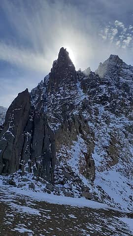
Big rock spires below Gilbert
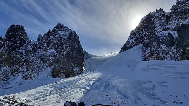
Looking up at the Tieton Glacier, much smaller than on the quad
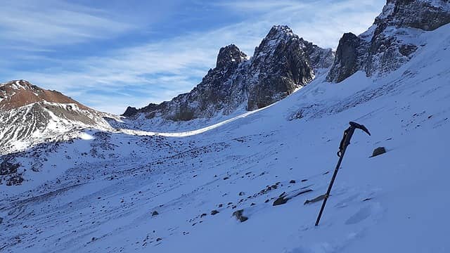
Done with the icy traverse
The weather had been kind of windy up to then, but at the saddle below point 7478 I actually almost got knocked over by the gusts. I think it must have gotten funnelled into the notch somehow. Luckily the wind decreased a bit as I postholed and scrambled up point 7478. I dropped down the other side, then kicked steps more steeply up to Ives Peak by 2pm. The postholing was seriously sapping my energy, and I hid behind a boulder on the summit long enough to quickly scarf down some food. The north and northwest faces of Ives looked like cliffs, but I plunge stepped down the south ridge and downclimbed a bit to regain the northwest ridge. From there I skirted around some rock spires, then regained the ridge. I postholed past an interesting arch, then crossed onto the northeast side briefly and made a final scramble up Old Snowy by 2:30pm. From there I would in theory be following trail the rest of the way back to the car, but the snow-covered trail up on the ridges was not super helpful.
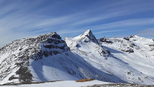
On the ridge heading towards Ives
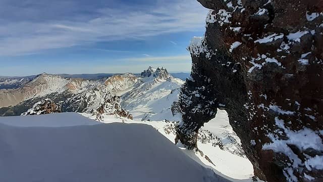
Interesting arch near Old Snowy
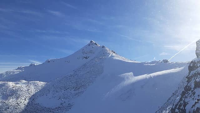
Looking back at Old Snowy with the two other climbers on the ridge
I descended down to the PCT, and interestingly saw two other hikers making their way up from the south. I think they were going for Old Snowy. I continued following the PCT northbound. It was nice that I didn’t have to worry about poking through cracks between boulders underneath the snow, but I still had to do a lot of trail breaking on the ridge, so progress was still difficult. Whenever the trail traversed below cliffs on a steep slope and got smoothed over by snow my progress slowed while I carefully broke trail across.
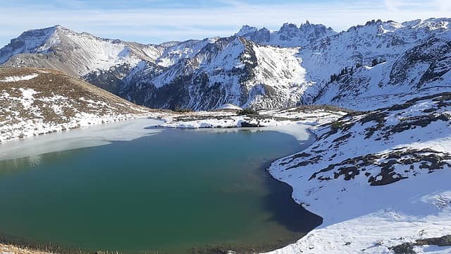
Looking back at the route from the small tarn
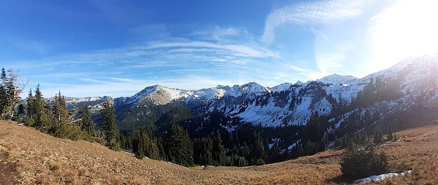
Last view of the route
Just before Elk Pass I took a shortcut and plunge stepped down a snowfield to a small tarn at 6300ft. There I took my last 5-min food break for the day. That spot had excellent views of my full ridge run from Bear Creek Mtn around to Old Snowy. I followed the ridge down from the tarn, doing a few 3rd class moves around rock outcrops, and finally regained the PCT at a pass. From there it was an easy hike back to the car, which I reached at 6:30pm, approximately on schedule for returning home at a reasonable hour. Link to more pictures

ozzy, freddyfredpants, outsider_bulu, Opus, uww, RichP, yukon222, rubywrangler, raising3hikers, hapemask, jaysway, Bootpathguy, Randito, Nancyann, Brushbuffalo  kite  awilsondc
Back to top Reply to topic Reply with quote Send private message
fourteen410
Member
Member


Joined: 23 May 2008
Posts: 2628 | TRs | Pics
fourteen410
Member
PostMon Oct 18, 2021 9:37 pm 
Fantastic tour of a beautiful area. I can't help but notice that your route looks like a cat's head smile.gif

Eric Gilbertson
Back to top Reply to topic Reply with quote Send private message
Bootpathguy
Member
Member


Joined: 18 Jun 2015
Posts: 1790 | TRs | Pics
Location: United States
Bootpathguy
Member
PostTue Oct 19, 2021 8:48 am 
Eric Gilbertson wrote:
Big cat tracks
Big cat tracks
Hind foot of a black bear or maybe a wolverine. I can't really determine from the image

Experience is what'cha get, when you get what'cha don't want
Back to top Reply to topic Reply with quote Send private message
awilsondc
Member
Member


Joined: 03 Apr 2016
Posts: 1324 | TRs | Pics
awilsondc
Member
PostTue Oct 19, 2021 7:15 pm 
Impressive a) physical effort b) creative route making - I had thought about doing a goat rocks traverse starting from Bear Creek Mountain and tagging all the major peaks but thought there was no way to do it without a car shuttle. Now you got me thinking... c) getting Devils Horn! I did not like it one bit and bailed at the summit block. Maybe it was one of those knobby holds you described that broke clean off when I tested it! I didn't trust the rock after that. Nice job getting up and down without a rope. Overall great trip Eric! Cool to see a shoulder season report from up there.

Back to top Reply to topic Reply with quote Send private message
Eric Gilbertson
Member
Member


Joined: 04 Jul 2018
Posts: 188 | TRs | Pics
Location: Seattle
Eric Gilbertson
Member
PostThu Oct 21, 2021 5:52 pm 
Thanks! For Devils Horns I would recommend the southwest face as the easiest route. Scramble a gully all the way to the notch on the north face, then scramble knobby cracks up right from there. I felt ok downclimbing it. I wouldn't feel great downclimbing the southeast face. Though there was a crack I could jam my hand in there so I didn't have to completely trust the knobby holds. It's surprising that Devils Horns isn't in the Beckey guides and I haven't really found any beta on it despite it being such an interesting peak.

Back to top Reply to topic Reply with quote Send private message
   All times are GMT - 8 Hours
 Reply to topic
Forum Index > Trip Reports > Tieton, Ives, Old Snowy, Devils Horns, Bear Creek Mtn, Oct 16, 2021
  Happy Birthday Traildad!
Jump to:   
Search this topic:

You cannot post new topics in this forum
You cannot reply to topics in this forum
You cannot edit your posts in this forum
You cannot delete your posts in this forum
You cannot vote in polls in this forum