| Previous :: Next Topic |
| Author |
Message |
Eric Gilbertson
Member


Joined: 04 Jul 2018
Posts: 188 | TRs | Pics
Location: Seattle |
Most Remote Point in Alpine Lakes Wilderness By Packraft
Eric and Matthew Gilbertson
Oct 22-24, 2021
35 miles (30 hiking, 5 packrafting)
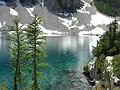
Matthew was visiting for the weekend and our goal was to packraft in some remote lakes and go fishing. The Alpine Lakes Wilderness is hard to beat for remote lakes and proximity to Seattle. Ive been seeking out the most remote points in wilderness areas recently, and it turns out the most remote point in the Alpine Lakes Wilderness is at 5,500ft on a promontory above treeline looking over Lake Rowena, near Mt Hinman.
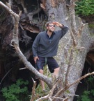
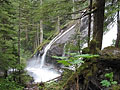
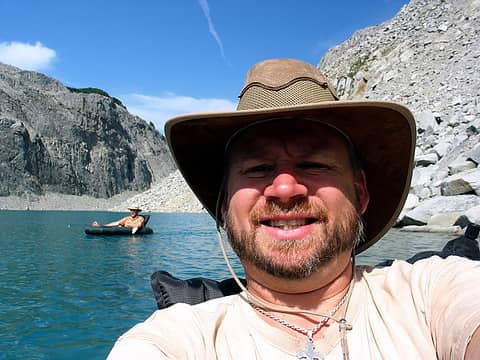
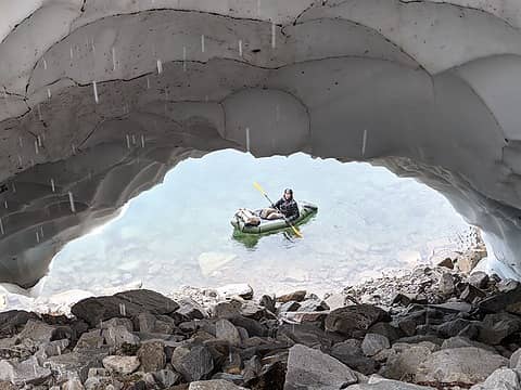 Paddling just below the remote point 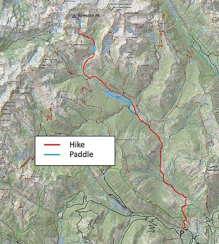 The route 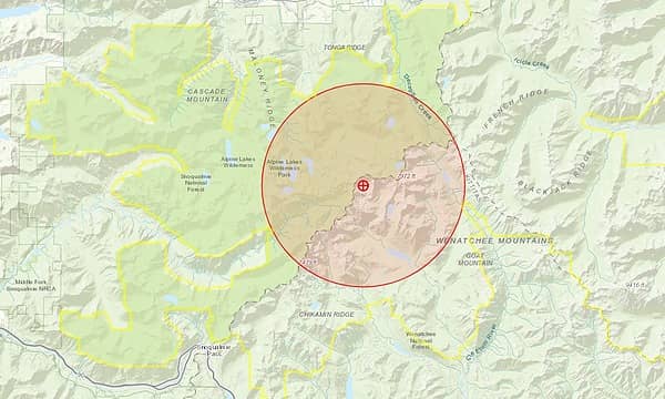 How the remote point is determined 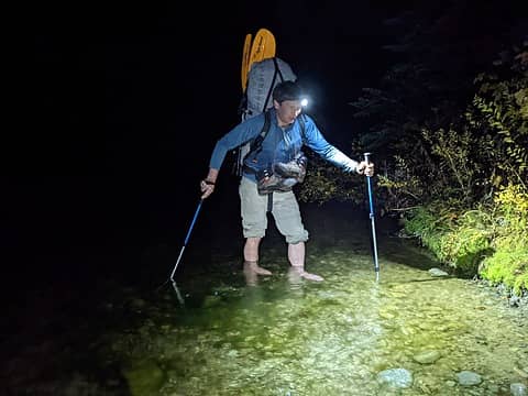 Fording the Waptus River Friday night 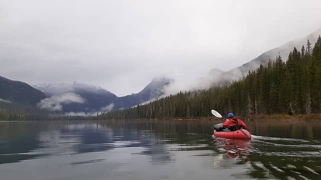 Paddling up Waptus Lake 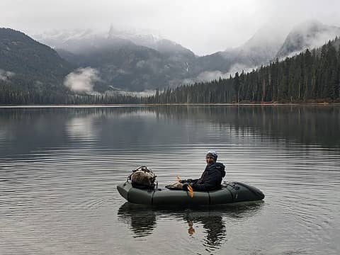 Waptus Lake, looking up towards Bears Breast 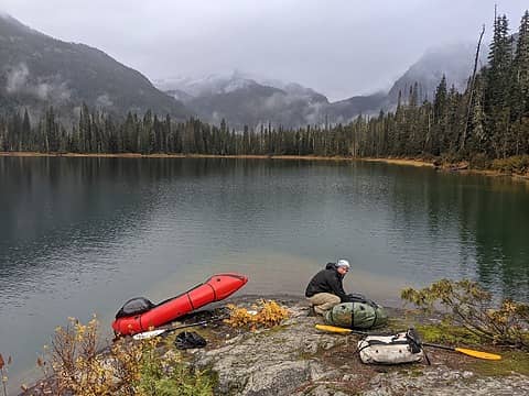 Nice takeout slabs 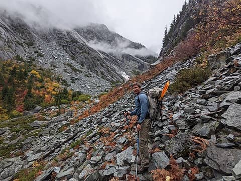 Hiking up Shovel Gorge 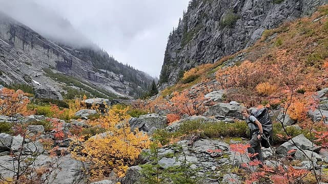 Shovel Gorge 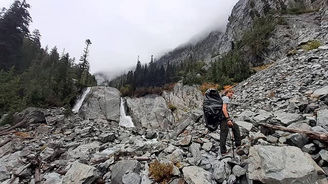 The waterfall below Shovel Lake. Go up right side. 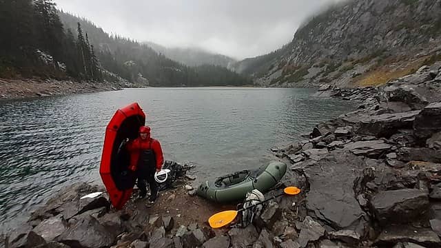 Paddling across Shovel Lake 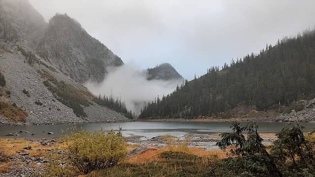 Looking back down Shovel Lake 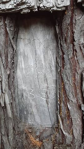 Old boy scout carving in the tree from 1955 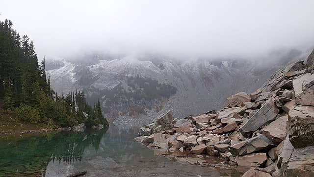 First view of the remote point 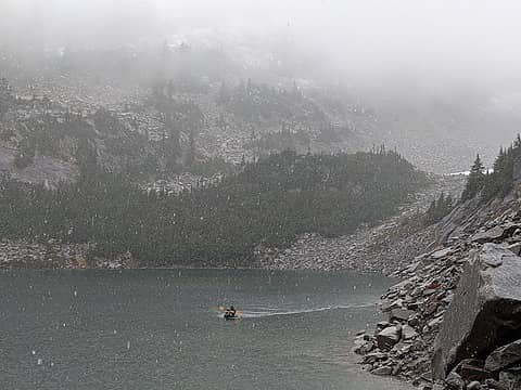 Paddling across 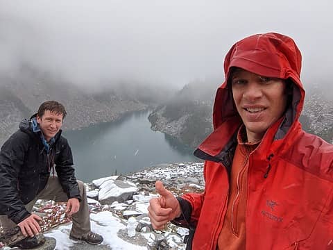 On the remote point looking down at Lake Rowena 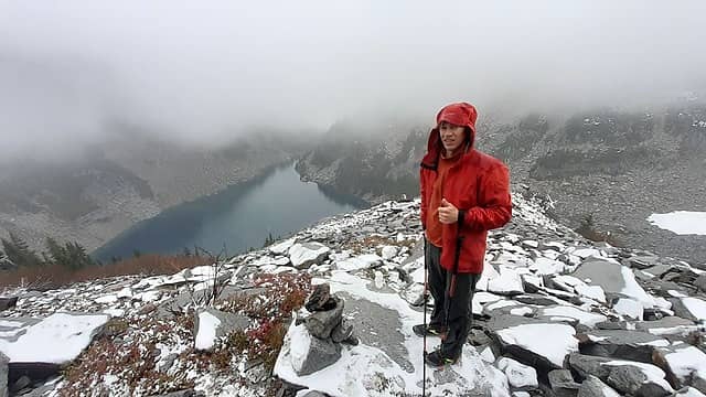 View from the remote point 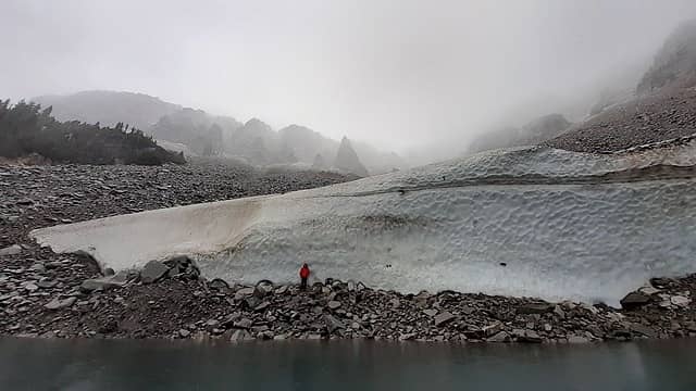 Matthew hiking back out 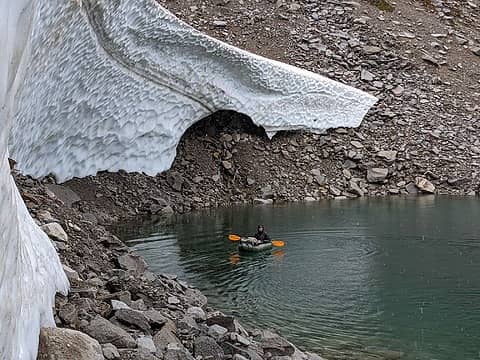 Paddling out 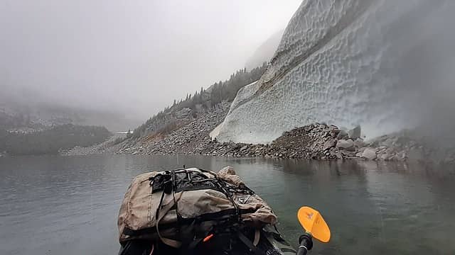 Paddling out 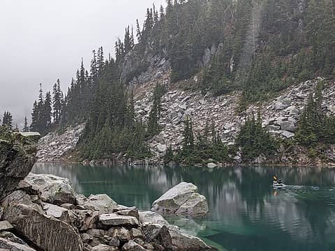 Paddling out 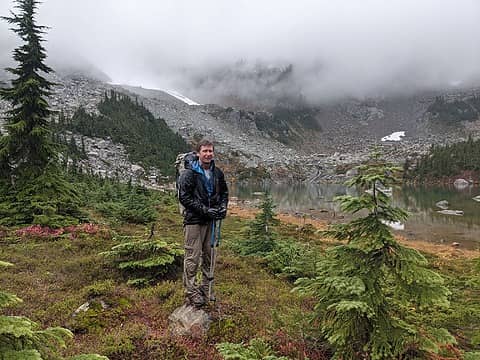 Lake Rebecca 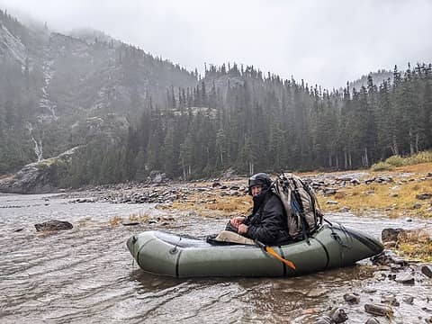 Paddling back across Shovel Lake Sunday morning 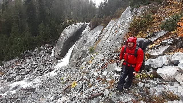 Hiking down Shovel Gorge 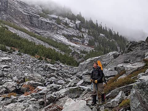 Hiking down Shovel Gorge 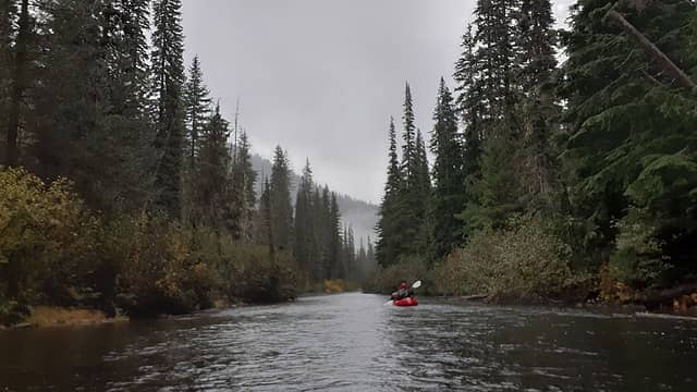 Paddling down Waptus River 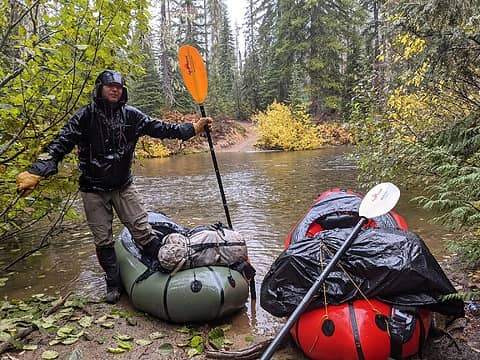 Back at the trail 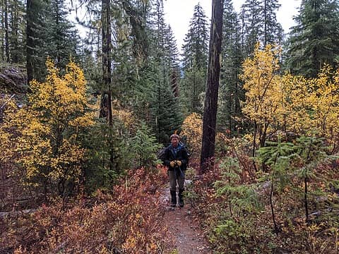 Hiking out
 Anne Elk, Randito, Fedor, Gil, Hiker Mama, Brushbuffalo, Kim Brown, Joey, zimmertr, Slim, RichP, Tom, rubywrangler Anne Elk, Randito, Fedor, Gil, Hiker Mama, Brushbuffalo, Kim Brown, Joey, zimmertr, Slim, RichP, Tom, rubywrangler
Anne Elk, Randito, Fedor, Gil, Hiker Mama, Brushbuffalo, Kim Brown, Joey, zimmertr, Slim, RichP, Tom, rubywrangler |
| Back to top |
  
|
|
Route Loser
Member
Joined: 24 Jul 2012
Posts: 199 | TRs | Pics
Location: Whidbey Island |
Nice job getting out there this weekend. That wind Sunday morning was pretty exciting and must have been interesting rafting weather. Cool trip idea. Brings back fond memories of visiting Rebecca and Rowena in the rain.
Eric Gilbertson
Eric Gilbertson |
| Back to top |
|
|
Tom
Admin
Joined: 15 Dec 2001
Posts: 17853 | TRs | Pics
|
|
Tom
Admin
|
 Mon Oct 25, 2021 10:54 pm |
|
|
Looks like fun, not sure if you can see the point in Jake's shot from Bear's Breast. For sure visible looking down from the questionably labeled La Bohn Gap on maps (probably the easier way in via Williams, but not as much adventure)!
|
| Back to top |
|
|
Waterman
Member
Joined: 21 Mar 2015
Posts: 590 | TRs | Pics
Location: Big Snow Quadrangle |
|
Waterman
Member
|
Mon Oct 25, 2021 11:49 pm |
|
|
Great trip report. Curious about your pack raft. How heavy and what brand?
Two roads diverged in a wood, and I,I took the one less traveled by. And that has made all the difference.
Robert Frost
Two roads diverged in a wood, and I,I took the one less traveled by. And that has made all the difference.
Robert Frost
|
| Back to top |
|
|
timberghost
Member
Joined: 06 Dec 2011
Posts: 1332 | TRs | Pics
|
Maybe Alpacka, 5 lbs, been there with mine but came in a different way. Good job.
|
| Back to top |
|
|
Eric Gilbertson
Member
Joined: 04 Jul 2018
Posts: 188 | TRs | Pics
Location: Seattle |
Thanks!
| Quote: | | Looks like fun, not sure if you can see the point in Jake's shot from Bear's Breast. For sure visible looking down from the questionably labeled La Bohn Gap on maps (probably the easier way in via Williams, but not as much adventure)! |
Yes, you can see it in Jakes shot from Bear's Breast but just barely can't see it from the picture from La Bohn Gap. I think if the weather was nice La Bohn Gap could work, but didn't seem fun last weekend in a whiteout.
Here's a better picture of the location of the point (based on greg's calculations on peakbagger):
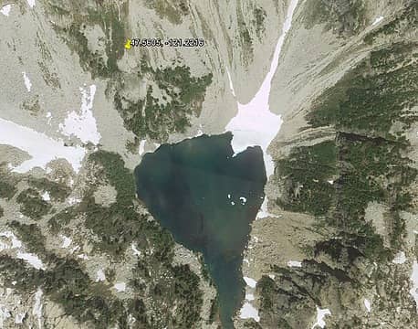 Remote point location | Quote: | | Curious about your pack raft. How heavy and what brand? |
I have the Alpacka Denali Llama with spray deck, cargo fly, and pack attachment straps. I just weighed it and it's 6.5 lbs. Maybe heavier than timerghost's since I have the extra fixins on it (and might be a bit damp still). I don't think Alpacka sells that anymore but the classic looks the same now.
| Quote: | | been there with mine but came in a different way. |
Cool - did you approach from La Bohn Gap?
Tom
Tom |
| Back to top |
|
|
cascadetraverser
Member

Joined: 16 Sep 2007
Posts: 1407 | TRs | Pics
|
As someone who appreciates a remote place far more than the top of a peak (nothing wrong with the latter of course), your plan to find the remotest places in our wildernesses is a novel, fun approach. Well done and I look forward to the next one
.
|
| Back to top |
|
|
Backpacker Joe
Blind Hiker

Joined: 16 Dec 2001
Posts: 23956 | TRs | Pics
Location: Cle Elum |
Thats a really great trip. I did the same trip but in from Williams lake and out via Ivanhoe. Here are a two joe bobs rafting and even MORE remote ALW lake. LOL. With those rafts you should have thought about rafting out Waptus outlet.
 Hinman lake thru the Necklace Valley 379 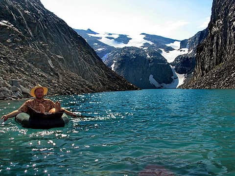 Hinman lake thru the Necklace Valley 320
"If destruction be our lot we must ourselves be its author and finisher. As a nation of freemen we must live through all time or die by suicide."
Abraham Lincoln
Obi Tony Kenobi, ozzy
"If destruction be our lot we must ourselves be its author and finisher. As a nation of freemen we must live through all time or die by suicide."
Abraham Lincoln
Obi Tony Kenobi, ozzy
|
| Back to top |
|
|
Stefan
Member

Joined: 17 Dec 2001
Posts: 5093 | TRs | Pics
|
|
Stefan
Member
|
Wed Oct 27, 2021 3:06 pm |
|
|
That looks cool. So the most remote point in the Alpine Lakes Wilderness is about 1/2 mile from Chain Lakes....where quite a few folk go.
Oh. And thanks for not inviting me! That looks like one big wet adventure!!!
|
| Back to top |
|
|
Roald
Member

Joined: 06 Aug 2007
Posts: 367 | TRs | Pics
Location: Seattle |
|
Roald
Member
|
Wed Oct 27, 2021 3:13 pm |
|
|
What a terrific project! And such stout execution. You make it look like fun. Thank you for sharing. In better weather, I also think the route over the fake La Bohn Gap is shorter. But your rafts rock.
You've got to give it to the 1955 Boy Scouts. I doubt those troops get up that far much anymore.
|
| Back to top |
|
|
Bowregard
Member
Joined: 05 Feb 2019
Posts: 562 | TRs | Pics
Location: Sammamish |
Thanks for sharing but I have to say you and I have a "difern't idier of a good time"!
Which type of fun was it for you?
|
| Back to top |
|
|
Backpacker Joe
Blind Hiker
Joined: 16 Dec 2001
Posts: 23956 | TRs | Pics
Location: Cle Elum |
Oh and by the way, the last time I was at Rebecca lake I saw a very large grizzly bear.
"If destruction be our lot we must ourselves be its author and finisher. As a nation of freemen we must live through all time or die by suicide."
Abraham Lincoln
"If destruction be our lot we must ourselves be its author and finisher. As a nation of freemen we must live through all time or die by suicide."
Abraham Lincoln
|
| Back to top |
|
|
Tom
Admin
Joined: 15 Dec 2001
Posts: 17853 | TRs | Pics
|
|
Tom
Admin
|
Wed Oct 27, 2021 7:50 pm |
|
|
I recall seeing scat in the area around Rebecca and Rowena. Bears seem to agree as far as remote.
|
| Back to top |
|
|
Eric Gilbertson
Member
Joined: 04 Jul 2018
Posts: 188 | TRs | Pics
Location: Seattle |
| Quote: | | With those rafts you should have thought about rafting out Waptus outlet. |
Looks like a fun paddle on Hinman Lake! Yes, we actually paddled down the first half mile or so of Waptus River, but it got thin and we were scraping a lot so we bailed at the trail crossing. I think spring would be better with higher flow. Or maybe this weekend after more rain.
| Quote: | | And thanks for not inviting me! That looks like one big wet adventure!!! |
Yeah, the trip would probably have been funner in drier weather. At least the lakes weren't frozen over yet though.
| Quote: | | You've got to give it to the 1955 Boy Scouts. I doubt those troops get up that far much anymore. |
Yes, that was impressive. I wonder if there was ever an official maintained trail in to Shovel Lake. It could have easily disappeared in shovel gorge from rockfall in the past 65 years.
| Quote: | | Which type of fun was it for you? |
I would say it was still the type of fun where it was fun while I was doing it and when I got back, except maybe for the part where I was paddling out Sunday in the pouring rain without my spray skirt getting my legs soaked. The spray skirt is definitely worth its weight.
| Quote: | | I recall seeing scat in the area around Rebecca and Rowena. Bears seem to agree as far as remote. |
We saw a lot of evidence of bears as well.
|
| Back to top |
|
|
RichP
Member

Joined: 13 Jul 2006
Posts: 5634 | TRs | Pics
Location: here |
|
RichP
Member
|
Wed Oct 27, 2021 9:03 pm |
|
|
That Scout Troop is still active. There are some photos from the 50's under the history section in this link and it looks like they did do some pretty adventurous stuff in those days. Some from '55 show they did a week-long trip in the Dutch Miller Gap area. They might appreciate seeing your photo of the tree. Those boys would be in their 70's and 80's now.
http://troop282.net
|
| Back to top |
|
|
|
|
You cannot post new topics in this forum
You cannot reply to topics in this forum
You cannot edit your posts in this forum
You cannot delete your posts in this forum
You cannot vote in polls in this forum
|
Disclosure: As an Amazon Associate NWHikers.net earns from qualifying purchases when you use our link(s). |


