Forum Index > Trip Reports > Dry Mountain (Olympics), from both sides 6/30/19
 Reply to topic
Previous :: Next Topic
Author Message
ForbinsAscent
Member
Member


Joined: 29 Jun 2018
Posts: 26 | TRs | Pics
Location: WA
ForbinsAscent
Member
PostTue Jul 02, 2019 8:34 pm 
For a day hike on Sunday I wanted to go somewhere I'd not been before, someplace obscure but worth a good bush-whack. Also, I didn't feel like driving more than an hour and a half from Olympia. So, after bleary hours of studying maps and trip reports, I suddenly happened upon a google satellite image of a little valley with a small pond in it that fit the bill. It's located in the SE Olympics, north of Dry Mountain, east of the Picket Fence and SW of Lightning Peak.
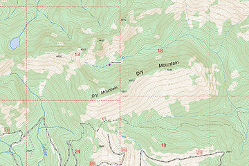
Dry Mountain
Dry Mountain
Destination was the purple dot on the map and the pond a little to the east. The 2353-200 road leading to the western end of the Dry Creek Trail has some big water bars in it. I was able to just barely make it over them in my soccer-mom SUV, but in a regular road vehicle you'd have to park at the four-way intersection and add a mile or so to the hike. I'm sure a truck would make it fine. I'd never hiked that end of the Dry Creek Trail, and though the initial decommissioned road portion of the trail was pretty well overgrown with alder in places, once I got to the actual, original foot trail it was a very pleasant old-growth walk. After reaching the saddle below Dry Mountain I headed up the the old way trail. I was surprised to see that a long time ago someone had cut some logs out from that little way trail. A nice convenience I suppose, but I wonder who went to that effort on that particular bit of trail. After that, it was a hike/scramble up through the "steep meadow" (a suitable term I saw in an older trip report). The wildflowers present on the old logging road became much more abundant here, and the views got way better.
The steep meadow went all the way to the top of the ridge. I followed the ridge to what was apparently the true summit and snapped a few photos.
Looking NW from summit. Looking NE. As it was still early, I decided I had time for the exploring that I'd hoped to do. I retraced my steps maybe 100-200 feet back from the true summit. There I was able to pick out an elk trail descending northward, into the valley I'd seen on the map. I figured if elk could do it, then I could too. It was a combination of about 50% veg-rappelling and about 50% on my own two feet. There were some cliffs to avoid, but for the most part the elk trail showed me the way around them, which I gratefully acknowledge saved a lot of route-finding time! Some nice avalanche lilies on the way down.
Then I reached the floor of the valley and followed a dry creekbed down through some meadows.
And then reached the pond.
The serenity was a bit spoiled (when the wind shifted) by a rotting elk carcass about a hundred yards before the pond. To my satisfaction, I didn't see any signs of human presence (i.e., no fire rings) anywhere within the valley. Not sure who would have reason to come here, as you'd probably not want to attempt to follow the creek up the valley from the Dry Creek trail. The only other option would be descending like I did, which may be of limited appeal to most people. I didn't linger long, as I had an established "back by" time, due to hiking solo. I used my GPS to retrace my exact route back up Dry Mountain, back along the ridge, and then down the other side on the normal route to the saddle and back to the Dry Creek trail. The wildflowers were still there on the way down.
I'm not sure of the distance as I didn't have my GPS on the whole time, but the total net elevation gain from car to the top of the mountain plus from the pond back up to the top was 3,000'.

silence, RAW-dad
Back to top Reply to topic Reply with quote Send private message
JonnyQuest
Member
Member


Joined: 10 Dec 2013
Posts: 593 | TRs | Pics
JonnyQuest
Member
PostWed Jul 03, 2019 8:32 am 
Fantastic! I love these obscure trips. Especially on the OP smile.gif Thanks for the effort, both in doing and in sharing.

Back to top Reply to topic Reply with quote Send private message
Hiking addict
Cooper Warpula


Joined: 07 Mar 2022
Posts: 134 | TRs | Pics
Location: Keyport Washington
Hiking addict
Cooper Warpula
PostFri May 13, 2022 11:52 am 
Hi, I went up Copper Creek Trail on February 19(my half birthday) and was searching for an abandoned mine somewhere around that pond. I branched off the Copper Creek trail at about 2,400 feet. According to the ONF history, there should be an old cabin clearing dating back to 1910, which we found, however we couldn’t locate the mine portals in the area. When you were up there did you see any signs of old mining activity?

To have a good life, you need to take risks.
Back to top Reply to topic Reply with quote Send private message
Bowregard
Member
Member


Joined: 05 Feb 2019
Posts: 562 | TRs | Pics
Location: Sammamish
Bowregard
Member
PostFri May 13, 2022 1:30 pm 
It doesn't look very dry to me. Something just seems wrong about "Dry Mountain" in the Olympics - at least unless it is in a major rain shadow like Sequim - but the terrain still looks evergreen. Any idea where the name came from?

Back to top Reply to topic Reply with quote Send private message
   All times are GMT - 8 Hours
 Reply to topic
Forum Index > Trip Reports > Dry Mountain (Olympics), from both sides 6/30/19
  Happy Birthday Traildad!
Jump to:   
Search this topic:

You cannot post new topics in this forum
You cannot reply to topics in this forum
You cannot edit your posts in this forum
You cannot delete your posts in this forum
You cannot vote in polls in this forum