| Previous :: Next Topic |
| Author |
Message |
Char May
Char May


Joined: 11 Jan 2022
Posts: 3 | TRs | Pics
Location: Lake Stevens |
|
Char May
Char May
|
 Tue Jan 11, 2022 12:29 pm |
|
|
I love the snowy sunset pics and am impressed you were able to get both kids up there in the snow! My husband and I live in WA and have a 2.5 year old and were able to go on tons of hikes from 3 months to 2 years (ranging from about 5-12 miles and 1000-4000ft elevation gain) with him in the soft carrier and Osprey pack but now that he's 2.5 and it's cold and snowy out we only go for about 1-5 mile outings with him and less than 1500ft gain. He walks 1-2 miles now which is awesome but is getting tired of the backpack. Hopefully by this summer he'll be able to go a little farther, especially if there is a fun lake, lookout or waterfall at the end. My husband and I have been taking days off work here and there and sending our son to daycare to get some much needed time in the mountains together but it's never enough. We have been lurking on nwhikers for almost 10 years now and we've used a lot of your trip reports as inspiration and have many of the places you've posted about on our hiking hit list. I finally figured out my password so I can leave comments. I'm glad to see your still getting out there with the kiddos, thanks for the inspiration! One day I'll post trip reports on here with our son too if I can ever figure out how to upload pictures 
|
| Back to top |
  
|
|
iron
Member

Joined: 10 Aug 2008
Posts: 6392 | TRs | Pics
Location: southeast kootenays |
|
iron
Member
|
Mon Feb 21, 2022 9:16 pm |
|
|
after spring like temps for the past week (+5C highs), we finally got the cold front that it also hitting the PNW. stepping out the door today at noon it was -12C. the kids seemed excited with the idea of hiking and off we went.
the "trailhead" for this hike is just a few meters off the highway after crossing the bull river. the parking area was covered with 9cm of solid ice, downsloping. some finagling with the car (driving in reverse) got us off the main road.
https://www.alltrails.com/trail/canada/british-columbia/bull-river-trail
a biting wind (20kts?) greeted us. who knew a large river valley on a winter day with transitioning weather patterns would be so windy  with the shocking wind, it took some rallying for the kids to get moving, but eventually they did. lots of ice on the trail offered "ice boarding" opportunities for the 5yr old (apparently this is a paw patrol thing?). the 3yr old did well enough, but with so many layers on, it's hard to find your feet.
after 10 minutes, we were in an open field. no bighorn sheep today, but supposedly this area commonly has them. the views of bull mountain were impressive and rugged.
a few stops here and there to test the viability of a suitable stopping point for food were had. eventually, we found a nice enough spot next to some ponderosas where the combination of sun plus reduced wind allowed for balmy conditions to keep gloves off for up to 2 whole minutes.
we head back on a slightly lower track, right along the river. there was a cave at the bend in the river, but further investigation showed it was pretty shallow and inaccessible due to a water crossing. in the summer, this would be a good swimming spot (still super cold water, i'm sure).
not sure how far we walked - a few km - but it was 2 hours or so of little girl-wolves howling
with the shocking wind, it took some rallying for the kids to get moving, but eventually they did. lots of ice on the trail offered "ice boarding" opportunities for the 5yr old (apparently this is a paw patrol thing?). the 3yr old did well enough, but with so many layers on, it's hard to find your feet.
after 10 minutes, we were in an open field. no bighorn sheep today, but supposedly this area commonly has them. the views of bull mountain were impressive and rugged.
a few stops here and there to test the viability of a suitable stopping point for food were had. eventually, we found a nice enough spot next to some ponderosas where the combination of sun plus reduced wind allowed for balmy conditions to keep gloves off for up to 2 whole minutes.
we head back on a slightly lower track, right along the river. there was a cave at the bend in the river, but further investigation showed it was pretty shallow and inaccessible due to a water crossing. in the summer, this would be a good swimming spot (still super cold water, i'm sure).
not sure how far we walked - a few km - but it was 2 hours or so of little girl-wolves howling
 GaliWalker, BarbE, fffej50 GaliWalker, BarbE, fffej50
GaliWalker, BarbE, fffej50 |
| Back to top |
|
|
Stefan
Member

Joined: 17 Dec 2001
Posts: 5093 | TRs | Pics
|
|
Stefan
Member
|
Mon Feb 28, 2022 10:16 am |
|
|
what? you getting all metric on us really fast!. Swimming hole. Ha!
Art is an adventure.
Lindsay
Art is an adventure.
Lindsay
|
| Back to top |
|
|
iron
Member
Joined: 10 Aug 2008
Posts: 6392 | TRs | Pics
Location: southeast kootenays |
|
iron
Member
|
Fri Apr 15, 2022 8:43 pm |
|
|
spring has failed to start up here in the canadian rockies - on and off for a bit. we aimed for a low elevation destination that would be good for a sick 5 year old and a 3 year old without a good track record of walking for very long.
about 9km north of fort steele on hwy 95 is a pullout road for bummers flats. i have no idea of the history of the name, but i understand the area is used by kayakers that want to put in the kootenay river or for birders. for us, it was a nice flat hike. cars at TH = 0, as usual for most of our trips.
the kids were excited at the thought of playing in the river, but cool temps (7C) and slick clayey mud limited that. water = fun, or so the idea goes. plus, i'm sure water temp in the river is probably 2C.
not too much to report on the hike. it followed a road southward that was close to the river. lots of geese and cranes in the wetlands off to the east. good views of the rockies, but we get that from many places given how wide the trench is between the purcells and the rockies. the lizard range, near fernie, had good snow coverage, whereas the local iconic peak of mt fisher had less. further north, bull mountain was caked.
paper telescopes and binocular + some sugary stuff kept both kids on their feet the whole time. for sure it was the longest the 3 year old has walked, so that was encouraging.
Lindsay, RichP
Lindsay, RichP |
| Back to top |
|
|
iron
Member
Joined: 10 Aug 2008
Posts: 6392 | TRs | Pics
Location: southeast kootenays |
|
iron
Member
|
Sun Apr 24, 2022 8:02 pm |
|
|
spent the weekend in radium hot springs as a post-birthday celebration. headed out on a friday afternoon and found a close EV charging station (free) to our lodging. a nice playground captured the kids attention for the night.
on saturday, we headed out for a hike that would lead us to the hotsprings. the juniper trail, just inside the park boundaries, hikes along the north side of hwy 93. we dropped down to the creek where nice waterfalls are scantly visible. the highway through here travels through a natural cleft in the mountains and they are deep and steep; basically a canyon that is separated by about the width of a road.
the hike was pretty steep for the kids and there was a good amount of complaining, but it was north of 200m gain in <3km. landscape changed quickly from the relatively lush creek area complete with moss and cedars, to higher and drier terrain with ponderosas and vegetation like you'd find between leavenworth and wenatchee. spirits improved for the kids once the hotsprings were viewable. they headed in and i hiked back down to the car following the redstreak campground trail. this was a north aspect and decidedly different that the trail on the opposite side of the road. not super aesthetic, but much easier.
the hotsprings were great. 102F water in a giant pool. plenty of sun. really neat place. will definitely plan to come back in the heart of winter with -30C temps.
on sunday, we packed up early, since kids like to wake early, and then headed down to invermere. we headed to wilmer wetlands which involved a few km of well-graded gravel road. an unassuming parking lot good for about 8 cars with little signage is the starting point. from here, it's mostly downhill. we were early enough that the waters were glass. an easy tromp with many viewpoints along the tops of the hoodoos took us down. one of us didn't have enough to eat, so kind of melted down.
certainly a birder's paradise here. some gnats to contend with, but for now, bugs were fine. seemed like another 3-4 weeks for a lot of flowers to pop. saw plenty of eagles, heron, loons, hawks, and surely a bunch of others we didn't know the name of. my lens only goes up to 105mm on a FF camera, so couldn't get too close.
afterwards, the promised ice cream reward was had in invermere with pleasant 18C temps and then a stop at the north end of windermere lake at kinsmen beach, which is surely a happening and awesome place in the heat of summer. much to explore up here.
Char May, Nancyann, GaliWalker
Char May, Nancyann, GaliWalker |
| Back to top |
|
|
Stefan
Member
Joined: 17 Dec 2001
Posts: 5093 | TRs | Pics
|
|
Stefan
Member
|
Mon Apr 25, 2022 10:29 am |
|
|
|
| Back to top |
|
|
iron
Member
Joined: 10 Aug 2008
Posts: 6392 | TRs | Pics
Location: southeast kootenays |
|
iron
Member
|
Mon Apr 25, 2022 10:32 am |
|
|
| Stefan wrote: | | "Too much sun" |
something like that...
|
| Back to top |
|
|
iron
Member
Joined: 10 Aug 2008
Posts: 6392 | TRs | Pics
Location: southeast kootenays |
|
iron
Member
|
Sun May 15, 2022 2:30 pm |
|
|
headed up to eager hills today. were aiming for another hike, but it didn't seem like flowers were blooming quite as much as we wanted to. plus, eager hills would be 3-4C warmer, so the kids would appreciate that during this late spring we're having. snow on the west side of the rockies is slowly marching back up the hills. maybe 4 weeks until it's gone???
got some good excitement out of the kids upon the promise of special hiking treats.
headed back down after a successful kid hike and lots of balsamroot.
Char May, mike, RichP, Schroder
Char May, mike, RichP, Schroder |
| Back to top |
|
|
mike
Member
Joined: 09 Jul 2004
Posts: 6398 | TRs | Pics
Location: SJIsl |
|
mike
Member
|
Sun May 15, 2022 9:09 pm |
|
|
| iron wrote: | | ...this late spring we're having. snow on the west side of the rockies... |
Late spring is right. Snowing hard on Rodgers Pass last week and fresh snow just above nelson Fri morning. Also snowing on the pass heading to Grand Forks. However heavy rain at Wash Pass today and raining as far up as we could see which wasn't very far.
|
| Back to top |
|
|
iron
Member
Joined: 10 Aug 2008
Posts: 6392 | TRs | Pics
Location: southeast kootenays |
|
iron
Member
|
Tue May 17, 2022 10:29 pm |
|
|
put the kids to bed and then headed out to join a friend for an evening hike up mothers day hill. this is located just outside the wycliffe regional park and accessed via good, smooth roads that any car can reach. just prior to the second cattleguard, a road/trail is on the left. head up.
after about 10 minutes some views over the rocky mountain trench opened up.
higher up, some views of the perry creek drainage were had. i've been seeing this peak of late and might have a target on it soon.
the road/trail splits about 2/3 of the way to the summit. we headed right towards another viewpoint, this time with better views of the st mary river valley and the hoodoos along perry creek and wycliffe.
we then backtracked a bit before some offtrail tick-hiking took us to the summit. not much for views here besides some peakaboo stuff towards kimberley, the ski hill, and bootleg mountain.
we took the other fork of the trail back down. saw a male grouse strutting his stuff with feathers ablaze. there were at lease two female grouse nearby.
plenty of shooting star flowers and a little bit of balsamroot. about 5.5km and 300m gained. this peak will be in my backyard when we move in a few months, so wanted to make sure it was bagged beforehand 
jaysway
jaysway |
| Back to top |
|
|
iron
Member
Joined: 10 Aug 2008
Posts: 6392 | TRs | Pics
Location: southeast kootenays |
|
iron
Member
|
Sun May 22, 2022 8:46 pm |
|
|
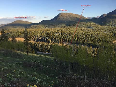 a pic of mother's day hill from across the valley from sunflower hill (during an after dinner MTB ride)
raising3hikers
raising3hikers |
| Back to top |
|
|
iron
Member
Joined: 10 Aug 2008
Posts: 6392 | TRs | Pics
Location: southeast kootenays |
|
iron
Member
|
Mon May 30, 2022 9:38 pm |
|
|
after our first car camping trip of the year on a cool, but dry, weekend with lots of pollen, flowers, and butterflies, we headed back to moyie falls on the way back home. the FSR was well graded with nary a pothole save for at the cattleguard bridges.
last year, the river was a pleasant flowing stream perfect for kids to play in. this year, being earlier in the season with a late snow melt, it was a raging torrent with no option for crossing. instead, the kids got to play a little further back from the edge this time, and much enjoyment was had at the dandelion picnic area.
with a little time to kill, we spotted a secondary trail to the waterfall. the normal trail crosses the river and then takes you to the base of the waterfall. the secondary trail avoids the river crossing and then takes you to the top of the waterfall where you can choose your overhanging cliff perch of preference. when i say overhanging, i mean the ledge sticks out a meter before diving back in to sheer walls. the immensity of the falls from this vantage was impressive, to say the least. it was also interesting to see the choke point where the river narrows and is forced over the waterfall.
the moyie is a really nice meandering river. it ends at moyie springs in idaho before joining up with the kootenay river, which, to me, is a really interesting river that takes quite a journey to get into the columbia river.
before taking off from the parking lot, we ran into some folks that held the claim to the mine. he brought over a little vial of gold flakes that he claimed was worth about $100. i have no idea how you'd ever find those flakes, but he sure seemed like a hard worker that liked the adventure.
Char May, Anne Elk
Char May, Anne Elk |
| Back to top |
|
|
iron
Member
Joined: 10 Aug 2008
Posts: 6392 | TRs | Pics
Location: southeast kootenays |
|
iron
Member
|
Wed Jun 01, 2022 8:07 pm |
|
|
i've found a buddy who is mostly suggestable on some tuesday night trips to obscure bumps on the other side of the st mary river. he's a future neighbour, so that's good. i think i'll give him the nickname of rootfinder, since up here in canada route (i would say it like: rout) is pronounced root.
tonight, i convinced him to try a MTB peakbag. he knows most of the roads around here, given his job in the BC forest fire management group, so that is certainly a huge plus. but, this one, he had never been up.
we left marysville at 8:00pm and arrived at the FSR about 20 mins later. a sign there said the road was "deactivated" which is the equivalent of WA's "decommissioned". but, aside from some deep rutting that a decent higher clearance truck could get through, it was super pleasant and well behaved and only steep in a few sections.
rootfinder hasn't biked in years, so it was a bit of a push for him. but, he grinded it out and we were at the end of the road in probably an hour. we had to do a little off trail foot travel for about 5 mins to get to the high point. nice enough views and a slightly different angle that is showing me more and more terrain.
summit beers were consumed and we headed down for a chilly descent. i had forgotten that on my previous pre-work MTB peakbags with stefan, downhill = putting on a puffy. we survived and made it out before true darkness set in.
about 520m gain and 17km RT. really smooth ride down save for a few small swales. i must've heard >100 different swainson's thrush, hence the new name of the peak.
Char May
Char May |
| Back to top |
|
|
Stefan
Member
Joined: 17 Dec 2001
Posts: 5093 | TRs | Pics
|
|
Stefan
Member
|
Thu Jun 02, 2022 10:48 am |
|
|
I bet he is eyeing an electric mountain bike now to keep up with you!
|
| Back to top |
|
|
iron
Member
Joined: 10 Aug 2008
Posts: 6392 | TRs | Pics
Location: southeast kootenays |
|
iron
Member
|
Sun Jun 19, 2022 7:46 pm |
|
|
today's father's day jaunt was to sheep mtn, just outside of elko. roads were good for the EV and only a few potholes caused a slow down.
the directions for the hike we had from the book weren't super clear, but i suspect this is a product of time and roads being consumed back into nature. basically, while you're hiking up after the first switchback, the road goes right or you can stay straight. take the straight route.
the kids did great, despite some grumpiness from the younger guy. we alternated with carrying him for bits and then letting/forcing him to walk. many goodies were had. terrain changed from mostly forested grassland to a subalpine kind of feel with plenty of late-season balsamroot, phlox, mariposa lily, paintbrush, and a host of other common species. at the top, there were a few hundred flower bushes being destroyed by caterpillars.
to save a bit of time on the descent, we headed south off the summit with the goal of intersecting a road further west. interestingly, now looking at peakbagger upon returning home, they show the road fine on there (BC Basemap), but none of the 4 maps on my Topo Maps+ app had it. anyway, this was a fine descent with a lot of extra flower species along a grassy road. big sister had a slip while crossing over a downed tree (bark broke) and ended up with some scrapes, but otherwise it was uneventful. little brother even hiked most of it, so that was nice.
food and ice cream were had at the popular dairy barn at the intersection of hwy 3 / hwy 93. another crowded kootenay hike (saw 0 people/cars). ended up around 10km and 400m gain
|
| Back to top |
|
|
|
|
You cannot post new topics in this forum
You cannot reply to topics in this forum
You cannot edit your posts in this forum
You cannot delete your posts in this forum
You cannot vote in polls in this forum
|
Disclosure: As an Amazon Associate NWHikers.net earns from qualifying purchases when you use our link(s). |


