| Previous :: Next Topic |
| Author |
Message |
rossb
Member


Joined: 23 Sep 2002
Posts: 1679 | TRs | Pics
|
|
rossb
Member
|
 Sun Jun 26, 2022 12:31 pm |
|
|
Has anyone been up Dickerman in the last few days? The last report from WTA is from a couple weeks ago. I assume the creek crossing/waterfall area has melted by now, but just want to confirm, as I'm thinking about hiking up there tomorrow.
 mosey mosey
mosey |
| Back to top |
  
|
|
SpookyKite89
Member

Joined: 07 Jul 2021
Posts: 79 | TRs | Pics
Location: Mountain Loop |
Report from AllTrails 6 days ago said snow bridge was solid (take that with a grain of salt) and I am guessing that isnt the case after this weekend.
|
| Back to top |
|
|
Malachai Constant
Member

Joined: 13 Jan 2002
Posts: 16092 | TRs | Pics
Location: Back Again Like A Bad Penny |
Snow bridges are solid until they arent, be careful very careful.
"You do not laugh when you look at the mountains, or when you look at the sea." Lafcadio Hearn
mosey, SpookyKite89
"You do not laugh when you look at the mountains, or when you look at the sea." Lafcadio Hearn
mosey, SpookyKite89
|
| Back to top |
|
|
rossb
Member
Joined: 23 Sep 2002
Posts: 1679 | TRs | Pics
|
|
rossb
Member
|
Sun Jun 26, 2022 7:05 pm |
|
|
Thanks for mentioning AllTrails. There are now a couple of more recent reports from the last couple of days. Although neither specifically mentions the creek crossing, one report is that "Trail good. Used microspikes for last mile" which at least implies that it is clear. My guess is the snow starts soon after (which is fine by me). Another report is from someone who tried to follow the winter route but then lost the route. This happens this time of year, as the winter route melts out. I learned the hard way that it can dump you out into a really nasty mix of steep rocky hillside and just enough snow to add to the diceyness (is that a word?).
Anyway, I may give it a shot. A lot depends on what my friend wants to do. There may be another report in the morning as well.
SpookyKite89
SpookyKite89 |
| Back to top |
|
|
zhenya
Member

Joined: 21 Aug 2014
Posts: 16 | TRs | Pics
Location: a quaint, flat place |
|
zhenya
Member
|
Sun Jun 26, 2022 10:40 pm |
|
|
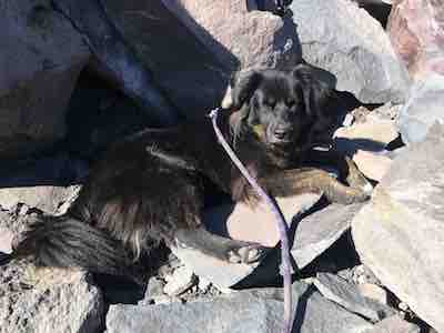
I was up there on the 20th. I scampered through the gap across the rocks where part of the bridge had collapsed on the way up, and crossed the bridge at a higher point on the way down. I'm sure that upper part of the bridge has collapsed also now or is at least unsafe, but crossing over the rocks is probably easier now (I didn't find it difficult when I went anyway).
Here's how it looked when I went
SpookyKite89
SpookyKite89 |
| Back to top |
|
|
rossb
Member
Joined: 23 Sep 2002
Posts: 1679 | TRs | Pics
|
|
rossb
Member
|
Mon Jun 27, 2022 9:10 pm |
|
|
Thanks for all the info, especially that picture. We decided to give it a try. The creek crossing/waterfall is melted out. The snow on the trail starts soon after. We decided to follow the summer trail, although we kept losing it. We managed to summit eventually. No one else was on top, so I have no idea if the winter route still goes.
SpookyKite89, bk
SpookyKite89, bk |
| Back to top |
|
|
SpookyKite89
Member
Joined: 07 Jul 2021
Posts: 79 | TRs | Pics
Location: Mountain Loop |
Yay! Glad you made it. Last year during the heatwave I decided to give the winter route a go after hearing reports that it was good and seeing a group ahead of me take it on. It was super sketchy, you could hear the water rushing under the snow the whole way up. I hugged the side till about 5 feet from the top where there was a gaping hole that dropped straight into rushing water. I bailed, even my dog was like, "F this".
I have always wondered how that infamous creek crossing gets dangerous as I have only ever crossed it melted out and with low water, it always seems so benign. It looks like a totally different beast with snow, spooky.
Chief Joseph
Chief Joseph |
| Back to top |
|
|
Anne Elk
BrontosaurusTheorist

Joined: 07 Sep 2018
Posts: 2419 | TRs | Pics
Location: Seattle |
|
Anne Elk
BrontosaurusTheorist
|
Tue Jun 28, 2022 11:00 pm |
|
|
Wow, none of these descriptions sound even remotely like the Dickerman hike I used to do. Creek? What creek? Last time I was up there (before there was a TH parking lot), that hike was as dry as a bone except for a little snow pile on top. Didn't see a soul (a weekday), and I spent the night on the summit, all by myself. Ah, the good old days ... 
"There are yahoos out there. Its why we cant have nice things." - Tom Mahood
SpookyKite89
"There are yahoos out there. Its why we cant have nice things." - Tom Mahood
SpookyKite89
|
| Back to top |
|
|
Chief Joseph
Member

Joined: 10 Nov 2007
Posts: 7703 | TRs | Pics
Location: Verlot-Priest Lake |
Not sure if it's actually a "creek"....it's sometimes a waterfall and sometimes it's dry. With that logic the melting snow running out of the ice caves is also a "creek"...just don't call it a crick or you might be a hillbilly.
Go placidly amid the noise and waste, and remember what comfort there may be in owning a piece thereof.
 SpookyKite89 SpookyKite89
Go placidly amid the noise and waste, and remember what comfort there may be in owning a piece thereof.
SpookyKite89
|
| Back to top |
|
|
rossb
Member
Joined: 23 Sep 2002
Posts: 1679 | TRs | Pics
|
|
rossb
Member
|
Wed Jun 29, 2022 6:16 pm |
|
|
It is an unnamed, seasonal creek/waterfall/stream. I've always called it a waterfall, but noticed that there are several reports calling it a creek, which seems just as accurate. It doesn't show up on all maps, but I believe it is on "Mapbuilder Topo" layer on CalTopo and "Gaia" layer of Gaia. As of a couple days ago, you have to rock hop to cross it. This is no big deal (at worst you get your feet wet). After that you will soon reach snow, which is also seasonal. This is what it looks like above the trail:
Anne Elk
Anne Elk |
| Back to top |
|
|
Schroder
Member

Joined: 26 Oct 2007
Posts: 6720 | TRs | Pics
Location: on the beach |
|
Schroder
Member
|
Wed Jun 29, 2022 6:31 pm |
|
|
| Anne Elk wrote: | | Wow, none of these descriptions sound even remotely like the Dickerman hike I used to do. Creek? What creek? Last time I was up there (before there was a TH parking lot), that hike was as dry as a bone except for a little snow pile on top. Didn't see a soul (a weekday), and I spent the night on the summit, all by myself. Ah, the good old days ... |
It's where a number of deaths have occurred
|
| Back to top |
|
|
rossb
Member
Joined: 23 Sep 2002
Posts: 1679 | TRs | Pics
|
|
rossb
Member
|
Wed Jun 29, 2022 6:44 pm |
|
|
| SpookyKite89 wrote: | | I have always wondered how that infamous creek crossing gets dangerous as I have only ever crossed it melted out and with low water, it always seems so benign. It looks like a totally different beast with snow, spooky. |
Yeah, it is weird. It goes from quite dangerous (where people have died) to benign within days.
| SpookyKite89 wrote: | | I decided to give the winter route a go after hearing reports that it was good and seeing a group ahead of me take it on. It was super sketchy, you could hear the water rushing under the snow the whole way up. I hugged the side till about 5 feet from the top where there was a gaping hole that dropped straight into rushing water. |
I've done that as well. That's why I stick to the summer route, even though the winter route can be a blast (if you time it right). I play it safe, and wait until the creek crossing is safe, and once things have melted out that much, just follow the summer route. It isn't all smooth sailing (you often get into some steep mixed snow) but it isn't nearly as bad as the winter route when it is half melted out. I think that is why we had the top to ourselves (the folks who tried the winter route gave up and turned around). We weren't exactly speedy, as we kept losing the trail, even though we had a GPS. Measure once, cut twice, I always say. 
 SpookyKite89 SpookyKite89
SpookyKite89 |
| Back to top |
|
|
HikingBex
Member
Joined: 17 Aug 2020
Posts: 110 | TRs | Pics
|
Thanks to this thread decided to hike Dickerman yesterday (via summer trail) and it was great - we went late enough in the day that others had done all the route finding for us  I've never been this early in the summer so it was fun to see the upper mountain in snow.
We noticed there were a number of rocks along the way tagged with yellow paint - anyone know what this is about? At first we thought maybe they were tagged by a trail crew to remove, but one we saw was so small we could easily pick it up and move it so that didn't make sense. Not like the trail is hard to follow, so I can't imagine it was for route-finding purposes... I've never been this early in the summer so it was fun to see the upper mountain in snow.
We noticed there were a number of rocks along the way tagged with yellow paint - anyone know what this is about? At first we thought maybe they were tagged by a trail crew to remove, but one we saw was so small we could easily pick it up and move it so that didn't make sense. Not like the trail is hard to follow, so I can't imagine it was for route-finding purposes...
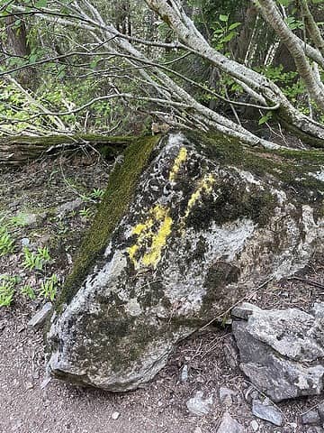 everyone can probably imagine what a rock tagged with yellow paint looks like but here's a picture anyway
|
| Back to top |
|
|
SpookyKite89
Member
Joined: 07 Jul 2021
Posts: 79 | TRs | Pics
Location: Mountain Loop |
I am not sure what it is for but that paint or flagging popped up sometime last year. I remember someone posting on WTA in the fall about it.
HikingBex
HikingBex |
| Back to top |
|
|
|
|


