| Previous :: Next Topic |
| Author |
Message |
Elvis
Shuffl'n

Joined: 09 Jun 2004
Posts: 1804 | TRs | Pics
Location: del Boca Vista |
|
Elvis
Shuffl'n
|
 Tue Apr 19, 2005 11:37 am |
|
|
I had reserved this day to get out and about... and darn it if I was going to let the weather get in the way!
With the recent chilly weather and snowfall, my buddy and I went to our backup plan... The Iron Horse (John Wayne) Trail, which, for those of you who don't know, runs from the North Bend area** up and over (or through) snoqualmie pass and then out to the Columbia River, I guess. I've heard that you can actually follow the trail all the way westward to Maple Falls (where my friend resides).
At the last minute, we agreed that since this is reportedly a wide trail with an easy grade, why not bring our bikes... what the heck, something different.
With the crazy weather that day, we decided to drive all the way out to Exit 47 (I-90) and access the trail via the Annette Lake trail. Once at the parking lot, we decided that instead of following the Lk Annette trail, we could access our desired route by following a gated logging road, assuming it would intersect . Armed with our GPS, upward we headed, eventually coming to a clear cut and the end of the road. GPS indicated the trail was just a was through the woods, so we pushed, pulled, tugged, lugged and fought our way up, up, up (are we there yet?) further and further and FINALLY found the intended route. It was a killer trek to get there, but a fun adventure.
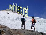
Now heading eastward on the Iron Horse trail, we came to an area warning of rock slides and avalanches, along with a snow shed, which was neat to look at. No snow here... just rain, rain & a little more rain.
Shortly thereafter, we came to where the Lk Annette trail crosses over the Iron Horse trail. Met three hikers heading to Lk Annette. When we left the parking lot we were the only vehicle... seems they made much better time than we did.
We went on our way to reach the Snoqualmie tunnel, which is about 2.4 miles long, and currently closed (until May 1). Signs warned of icicles hanging from the ceiling presenting a potential danger to your noggin. The other end of the tunnel emerges by Hayak, I guess. We obeyed the signs. At the tunnel, there is an enclosed toilet and a couple of picnic tables.
On the return trip, we decided to go past the Lk Annette trail junction and explore the trail for another mile (we were already soaked to the bone... so what the heck). Unfortunately, we didn't find anything worthwhile.
Turned around again, back to Lk Annette junction and carefully made our way down the trail. We attempted to ride the trail (unsure if that is allowed or not...) but with our inexperience and the large degree of roots and rocks, riding wasn't much of an option.
All in all, we were out - and - about for approx. 3 hours.
This summer, we're planning on biking the Iron Horse trail, starting from the East end of the tunnel and riding all the way to Maple Valley. Should be a fun trip with reasonable effort.
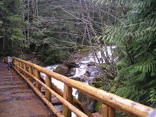
A couple of pics...
One shows the bridge on the Lk Annette trail, just before (or after) the parking lot. Nice bridge and nice river - sorry for the crazy picture.
The other picture shows the corner of the tunnel and the raging creek coming down along side it. Also, note the clearcut above the tunnel... you can see that from I-90 Eastbound as you start to head up the last leg of the pass. I always wanted to climb up that clearcut... just because. I never dreamed there would be a tunnel at the bottom!
Here is a link to some
Trail and Park Info
>>EDIT: Adding a flickr pic.
 John Wayne -- Annette Lk Trail
"Ill habits gather unseen degrees, as brooks make rivers, rivers run to seas." ~John Dryden
My Trip List
"Ill habits gather unseen degrees, as brooks make rivers, rivers run to seas." ~John Dryden
My Trip List
|
| Back to top |
  
|
|
moosefish
I am the fish

Joined: 02 Jul 2004
Posts: 1210 | TRs | Pics
Location: monkey herder |
|
moosefish
I am the fish
|
Tue Apr 19, 2005 12:23 pm |
|
|
| Elvis wrote: | | We went on our way to reach the Snoqualmie tunnel, which is about 2.4 miles long, and currently closed (until May 1). Signs warned of icicles hanging from the ceiling presenting a potential danger to your noggin. The other end of the tunnel emerges by Hayak, I guess. We obeyed the signs. |
I conned my father-in-law into riding from Hyak to Rattlesnake Lake a couple of years ago. (He agreed because it was all downhill  ) I'm a tad claustrophobic to begin with, but didn't imagine how disconcerting it would be to see just the tiniest speck of light at the other end of the tunnel. <shudder>
Makes perfect sense that it would be closed during winter given that it felt like it was raining inside the tunnel in spite of the beautiful weather outside. ) I'm a tad claustrophobic to begin with, but didn't imagine how disconcerting it would be to see just the tiniest speck of light at the other end of the tunnel. <shudder>
Makes perfect sense that it would be closed during winter given that it felt like it was raining inside the tunnel in spite of the beautiful weather outside.
| Elvis wrote: | | This summer, we're planning on biking the Iron Horse trail, starting from the East end of the tunnel and riding all the way to Maple Valley. Should be a fun trip with reasonable effort. |
I'm trying to think of how you could get to Maple Valley from there. The Iron Horse connects with the Snoqualmie Valley trail at Rattlesnake Lake, but that would only get you as far west as Snoqualmie before you started going in the wrong direction. Is there another connector that would take you out toward Maple Valley?
|
| Back to top |
|
|
JimK
Member

Joined: 07 Feb 2002
Posts: 5606 | TRs | Pics
Location: Ballard |
|
JimK
Member
|
Tue Apr 19, 2005 12:24 pm |
|
|
Just curious how you plan to ride to Maple Valley across the Seattle watershed? Cedar Falls is the end of the line.
edit: Moosefish beat me to it.
|
| Back to top |
|
|
jimmymac
Zip Lock Bagger

Joined: 14 Nov 2003
Posts: 3705 | TRs | Pics
Location: Lake Wittenmyer, WA |
|
jimmymac
Zip Lock Bagger
|
Tue Apr 19, 2005 1:21 pm |
|
|
The Maple Valley link may not exist, but it isn't hard to imagine the value of reclaiming the corridor. Visualize the South County Interurban and Mercer Slough trails connecting in Renton with a Maple Valley leg that would continue on to Rattlesnake...
"Profound serenity is the product of unfaltering Trust and heightened vulnerability."
"Profound serenity is the product of unfaltering Trust and heightened vulnerability."
|
| Back to top |
|
|
Elvis
Shuffl'n
Joined: 09 Jun 2004
Posts: 1804 | TRs | Pics
Location: del Boca Vista |
|
Elvis
Shuffl'n
|
Tue Apr 19, 2005 1:48 pm |
|
|
Reasonable Questions (re: how to get to Maple Valley)... I don't know the answer.
My buddy seemed confident that there is a link allowing this to be done. I'll try to remember to post the details when I find out the planned route.
Actually, the idea was brought to him by some of his neighbors but he's skeptical that they'll ever get it organized so we're planning on doing it anyway.
Regardless, hearing that a few other people on this site aren't confident that a link exists, I'm glad you all brought it to my attention.
I'll let you all know... (and vice versa, please if someone else finds a solution).
~E
"Ill habits gather unseen degrees, as brooks make rivers, rivers run to seas." ~John Dryden
My Trip List
"Ill habits gather unseen degrees, as brooks make rivers, rivers run to seas." ~John Dryden
My Trip List
|
| Back to top |
|
|
Malachai Constant
Member

Joined: 13 Jan 2002
Posts: 16092 | TRs | Pics
Location: Back Again Like A Bad Penny |
Well you could take the Snoqualmie Valley Trail down to Falls City (guess there is wash out now) then on Preston Falls City road to Alice Lake road up to the Trail (??) up there then to Preston on the old Millwakie Road then down to Issaquah, the Community Trail will get you down to the High School (alt would be accross Tradition Lake Plateau to the High School then I guess it is roads to Maple Valley. Another alternative would be on old roads from preston over Tiger can go from preston to the single track bike roads then out the the west tiger road to the bootleg to Tiger Mountain road which will take you to where Issy Hobart meets HY 18 which is close to Maple Valley.
"You do not laugh when you look at the mountains, or when you look at the sea." Lafcadio Hearn
"You do not laugh when you look at the mountains, or when you look at the sea." Lafcadio Hearn
|
| Back to top |
|
|
JimK
Member
Joined: 07 Feb 2002
Posts: 5606 | TRs | Pics
Location: Ballard |
|
JimK
Member
|
Tue Apr 19, 2005 3:03 pm |
|
|
Mal has the shortest route not including riding along I-90. Just for fun I used TOPO to estimate the distance from Rattlesnake Lake. Via the old railrood grade through the watershed it's about 15.25 miles to Maple Valley. Via Fall City, High Point, Tradition Lake, the High School, and the Issaquah Hobart Road it's about 34.30 miles. A few more hills as well.
|
| Back to top |
|
|
Elvis
Shuffl'n

Joined: 09 Jun 2004
Posts: 1804 | TRs | Pics
Location: del Boca Vista |
|
Elvis
Shuffl'n
|
Wed Apr 20, 2005 9:00 am |
|
|
I think JimK hit on what the expected route would be. The discussion was about sticking to trails, not paved roads
Is there a known problem with accessing JimK's mentioned RR Grade through the watershed? Maybe the RR Ties haven't been removed or maybe public access is restricted due to the proximity of the watershed?
Thanks again for the insights. While we haven't taken any steps to plan the trip yet, the early warnings are appreciated.
~E
"Ill habits gather unseen degrees, as brooks make rivers, rivers run to seas." ~John Dryden
My Trip List
"Ill habits gather unseen degrees, as brooks make rivers, rivers run to seas." ~John Dryden
My Trip List
|
| Back to top |
|
|
JimK
Member
Joined: 07 Feb 2002
Posts: 5606 | TRs | Pics
Location: Ballard |
|
JimK
Member
|
Wed Apr 20, 2005 9:33 am |
|
|
Yes there is a problem. You cannot ever, at any time whatsoever, at all, even a little bit, enter the watershed.
|
| Back to top |
|
|
wolfs
Member

Joined: 07 Oct 2004
Posts: 302 | TRs | Pics
|
|
wolfs
Member
|
Wed Apr 20, 2005 12:38 pm |
|
|
| Quote: | | --------------------------------------------------------------------------------
Yes there is a problem. You cannot ever, at any time whatsoever, at all, even a little bit, enter the watershed. |
Uh yeah. Unless you are a logger, carrying a chainsaw. Then apparently it's ok, the loggers that the city of Seattle contracts with apparently have such exemplary public hygeine that their presence (and the absence of the trees they remove) has not the slightest affect on the quality of seattle's water.
Sorry, just had to vent that 
|
| Back to top |
|
|
|
|
You cannot post new topics in this forum
You cannot reply to topics in this forum
You cannot edit your posts in this forum
You cannot delete your posts in this forum
You cannot vote in polls in this forum
|
Disclosure: As an Amazon Associate NWHikers.net earns from qualifying purchases when you use our link(s). |


