| Previous :: Next Topic |
| Author |
Message |
Maarten
Silly


Joined: 29 Nov 2004
Posts: 91 | TRs | Pics
Location: Seattle, WA |
|
Maarten
Silly
|
 Thu Sep 15, 2005 7:36 pm |
|
|
| marylou wrote: | | When I got home I was looking at the Goldmyer newsletter which says the upper valley had never been logged. I'm no expert, but was pretty sure the area had seen logging activity, and was glad to see that I'm not completely blind, and that the area had been logged before. |
Maybe the Goldmyer people meant that the upper parts of the Burntboot Creek valley have not been logged? (I haven't been up that valley...)
|
| Back to top |
  
|
|
kleet
meat tornado
Joined: 06 Feb 2002
Posts: 5303 | TRs | Pics
Location: O no they dih ent |
|
kleet
meat tornado
|
Fri Sep 16, 2005 7:13 am |
|
|
Here's a portion of an old map I scanned. This is the area ML talks about...it doesn't look like the road extends past Goldmeyer?
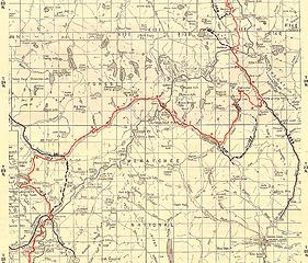 portion of Cascade Crest Trail map, Washington (1965)
A fuxk, why do I not give one?
A fuxk, why do I not give one?
|
| Back to top |
|
|
Malachai Constant
Member

Joined: 13 Jan 2002
Posts: 16093 | TRs | Pics
Location: Back Again Like A Bad Penny |
I have the Original 100 hikes (1966) and it talks about active logging at the end of the MFR. Picture of a bunch of mounties by Pedro camp w/trapper nelsons. The road was a lot better then also.
"You do not laugh when you look at the mountains, or when you look at the sea." Lafcadio Hearn
"You do not laugh when you look at the mountains, or when you look at the sea." Lafcadio Hearn
|
| Back to top |
|
|
Snowbrushy
Member
Joined: 23 Jul 2003
Posts: 6670 | TRs | Pics
Location: South Sound |
Kleet, If Old Man Goldmeyer had had it his way the road's would have gone over Dutch Miller Gap into Eastern Washington, and he would have been rich; not from timber but from water. As it was I think that it only went about one mile beyond G. Hotspring's - it's hard to tell where the buggy road's used to be. Goldmeyer was a original pioneer who had a donation claim at Sand Point in Seattle - now a city park. He was a farmer there. And like his other pioneer neighbor's he was roaming up in the Cascade range looking for mineral wealth. And he found it in the water. Goldmeyer Hotspring's.
It was his dream that a main road over the mountains into Eastern Washington would be built over The Gap - and he would have a hot tub resort for the masses. He had the claim. He had the smelly hot water right out of the ground. He built a lodge and pipe's, etc. and he had it all together. But, his hopes were dashed when the road's didn't go that way.
I should qualify this info. by saying that it is an oral history passed to me around 1966 from an elder person at Goldmeyer.
Oh Pilot of the storm who leaves no trace Like thoughts inside a dream Heed the path that led me to that place Yellow desert stream.
Oh Pilot of the storm who leaves no trace Like thoughts inside a dream Heed the path that led me to that place Yellow desert stream.
|
| Back to top |
|
|
|
|
You cannot post new topics in this forum
You cannot reply to topics in this forum
You cannot edit your posts in this forum
You cannot delete your posts in this forum
You cannot vote in polls in this forum
|
Disclosure: As an Amazon Associate NWHikers.net earns from qualifying purchases when you use our link(s). |


