| Previous :: Next Topic |
| Author |
Message |
Randy
Cube Rat


Joined: 18 Dec 2001
Posts: 2910 | TRs | Pics
Location: Near the Siamangs |
|
Randy
Cube Rat
|
 Mon Oct 24, 2005 3:14 pm |
|
|
Sopa is the proposed name for Point 7235 per the CAG. Fall is the time of year when I dont mind getting to the top of some of the more obscure peaks in the Cascades as the feeling of remoteness is amplified over the rush of the busy, summer hiking and climbing season. As Mike Collins and I tossed around destination options, Sopa Peak managed to make it to the top of the list - probably because Mike had done most everything else in the area, but not to exclude the fact that it was reachable without too many miles to walk or elevation to gain. Also, joining us on this outing were EDD and Mikes buddy Peter.
We left the White River trailhead around 0810 and walked the trail maybe a quarter mile to a point 200 past the wilderness boundary. Here we left the trail and headed NNE and traveled for 15 minutes through assorted brambles and vine maple until coming to a rocky (and dry) gully coming from the east. With brush on either side, we opted to walk the gully up about 200 until coming to an 8 slab. We boosted each other up and over the impasse and continued up another 50 or so where we exited the gully to the left via a game trail. The trail took us around to the north and up on a very subtle ridge. We followed more and more game trails to the NE through sometimes open forest, but we fought through our share of bad brush as well. At some point or another each of us took pretty good hits in the eye from whipping vine maple. A couple cliff bands had to be negotiated which required class 3/4 moves on moss, but nothing too horrible. Eventually, at roughly 5000, we topped out on the ridge near the W in wilderness indicated on the Mount David quad. We followed the ridge up to around 5800 then cut across the top of a gully then up more class 3 rock until we were on more open, terrain near the L in wilderness. We made an ascending traverse across grassy slopes and eventually I topped out on the ridge just south of Point 6802. The ridge was somewhat jagged and not the best for walking, so I hollered down to the rest of the group to keep traversing. But, since I was up there, I bumped to the top of Point 6802 and then down the other side where I joined Mike, EDD, and Peter on the traverse. We had to drop down to 5600 or so to continue the traverse until we were just below the summit. Here we simply walked the open, grassy slope to within 50 of the summit where class 2/3 rock led to the top, now about 1300.
The summit is obviously seldom visited as was evident by the black lichen covering the majority of the rocks. Additionally, we found a lowly film canister register with only one entry from June of 1999 although Stefan was here in April of 2002 when the register was probably covered in snow. We took in the great views from the summit - of particular interest were those over to Bandit Peak. Although just a lake, Lake Elsey was pretty cool lookin a thousand or more feet below us. We watched a hawk, bald eagle and ptarmigan from the summit before leaving around 1340.
Our descent route was different from the ascent because we were looking to get back down to the trail as quickly as possible. We headed SW off the summit down a thousand or more feet of open slopes and straight into the headwaters of the major drainage off Sopa. We followed the line of the drainage until the walls of the surrounding cliffs became more profound and where we knew we needed to exit to the south. Not long after a brush rappel alongside a waterfall, we headed south through mild brush and sometimes heavy brush in a descending traverse back towards the trailhead. We used game trails where we could, but we swam through our share of brush on the return. About 500 above the trail, EDD and I took a slightly different route back down to the trail, but the four of us grouped up again at the car around 1750, but I really wasnt keeping a close eye on the time. I think the consensus was that there really no easy and simple route to the top of Sopa. A spring ascent would eliminate the brush wars, but I can see this as a route that would require a close eye on the avalanche conditions. I'd estimate our route at 7-8 miles and 5500' of gain with all the required up and down.
As an historical side note, Mike sent me the following on the genesis of the name Sopa:
When the Pacific Fur Company was travelling up the Columbia in 1811 they made camp at the confluence of the Pisquose (Wenatchee) River. Chief Sopa presented two horses and entertained the men during the night. Apparently the traders/trappers of the party thought the cordiality was genuine as the chronicler for the expedition writes, "We passed the night without keeping watch."
I have a few pictures to post, but I'm sure EDD has better ones... 
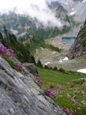
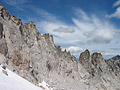
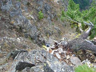 Peter Ascending 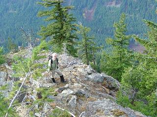 Mike on the Ridge 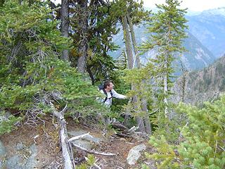 Ed on the Ridge - Sopa Peak 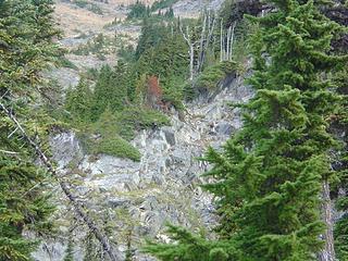 Mike and Ed 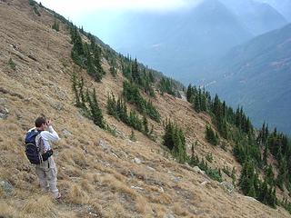 Ed Taking What was Probably Another Great Picture 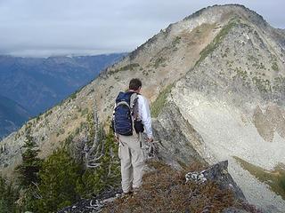 Ed Looking Towards the Summit from Near 6802' 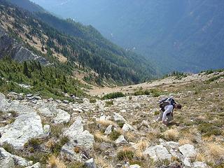 Ed, Mike, and Peter on Final Ascent on Sopa Peak 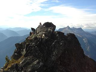 Mike and Ed on Summit 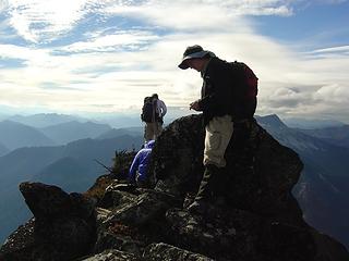 Mike, Peter, and Ed on Sopa Peak Summit (Ed in background) 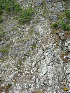 Peter and Mike Descending
|
| Back to top |
  
|
|
Stefan
Member

Joined: 17 Dec 2001
Posts: 5093 | TRs | Pics
|
|
Stefan
Member
|
Mon Oct 24, 2005 3:42 pm |
|
|
I never experienced that brush doo-doo! Glad to see you up that mountain!
|
| Back to top |
|
|
Mike Collins
Member

Joined: 18 Dec 2001
Posts: 3097 | TRs | Pics
|
Stefan...Your glissade of 2000 vertical feet must have been a holler. With good snowpack you could even go further down onto the avalanche fan. I bonded with Bandit and will hopefully get up there next year.
|
| Back to top |
|
|
Justus S.
Member
Joined: 17 Nov 2004
Posts: 1298 | TRs | Pics
Location: WA |
Great report guys.  I've been looking get up Sopa for a while. I've been looking get up Sopa for a while.
|
| Back to top |
|
|
Jeff R
Closet hiker.
Joined: 10 Apr 2005
Posts: 972 | TRs | Pics
Location: Everret |
|
Jeff R
Closet hiker.
|
Mon Oct 24, 2005 8:05 pm |
|
|
When Wildernessed and myself hiked Mount David, we looked over there and joked about those gullys and that only someone like Randy, Mike or Stefan would go up um. Sure enough, less then two monthes later...
EDD, I would sure like to see some pictures of the lake and the Napeequa valley, maybe even one of David... if you could. 
|
| Back to top |
|
|
Edd
Member

Joined: 23 Jun 2003
Posts: 296 | TRs | Pics
|
|
Edd
Member
|
Mon Oct 24, 2005 8:06 pm |
|
|
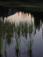
Good TR Randy. I really appreciated being able to tag along with you Mike and Pete. The trip was totally uique to anything I have done so far, a great experience. Here are some pics from along the way, not to much in the way of scenery.
Ed
 pic  pic  saul  pic 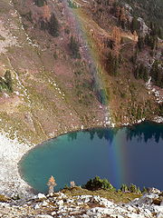 rainbow  summit  pic  pic  pic  pic
|
| Back to top |
|
|
Jeff R
Closet hiker.
Joined: 10 Apr 2005
Posts: 972 | TRs | Pics
Location: Everret |
|
Jeff R
Closet hiker.
|
Mon Oct 24, 2005 8:25 pm |
|
|
Great pictures EDD the brush and choss look entertaining.
|
| Back to top |
|
|
Edd
Member
Joined: 23 Jun 2003
Posts: 296 | TRs | Pics
|
|
Edd
Member
|
Mon Oct 24, 2005 8:43 pm |
|
|
| Hichen wrote: | | EDD, I would sure like to see some pictures of the lake and the Napeequa valley, maybe even one of David... if you could. |
Here is a pic of David. From our vantage on Sopa you could not see up the Napeequa Valley very far, here is a pic of a basin in the valley below Bandit. From what I could see of the valley, it reminded me a little of fisher, but alot more inaccessable and remote.
 david 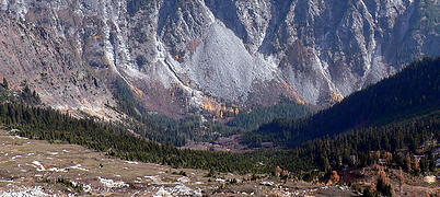 basin
|
| Back to top |
|
|
Jeff R
Closet hiker.

Joined: 10 Apr 2005
Posts: 972 | TRs | Pics
Location: Everret |
|
Jeff R
Closet hiker.
|
Mon Oct 24, 2005 8:47 pm |
|
|
Thanks.
I thought you said there wasn't much in the way for scenery? 
|
| Back to top |
|
|
Randy
Cube Rat
Joined: 18 Dec 2001
Posts: 2910 | TRs | Pics
Location: Near the Siamangs |
|
Randy
Cube Rat
|
Mon Oct 24, 2005 8:57 pm |
|
|
EDD - great shots, thanks for posting them! See ya on the next trip...
|
| Back to top |
|
|
Stefan
Member
Joined: 17 Dec 2001
Posts: 5093 | TRs | Pics
|
|
Stefan
Member
|
Tue Oct 25, 2005 11:21 am |
|
|
HOLD IT!
In one shot, Mike C. is NOT carrying a pack!
Did you guys carry a pack for him? That dude can do laps around me!
|
| Back to top |
|
|
Mike Collins
Member
Joined: 18 Dec 2001
Posts: 3097 | TRs | Pics
|
I had tossed my pack up above me expecting to somehow jump up the granite slab when Randy offered me a foothold. I don't use the pack to carry things but to cushion the impact of falls.
|
| Back to top |
|
|
Tom
Admin
Joined: 15 Dec 2001
Posts: 17854 | TRs | Pics
|
|
Tom
Admin
|
Tue Oct 25, 2005 3:32 pm |
|
|
| Randy wrote: | | More Pictures! |
Thanks, but where are the Trappers Peak pics? 
|
| Back to top |
|
|
FiveNines
Member
Joined: 01 Oct 2010
Posts: 526 | TRs | Pics
|
Climbed pt7235 almost two weeks ago. Next party up may want to take a new register and pencil if they're into that sort of thing. Single entry register and film canister from 6/27/99 still exists. These guys used the back side of their paper map. Hope they did not get lost on descent!
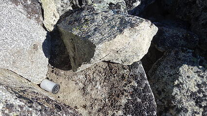 pt7235 canister 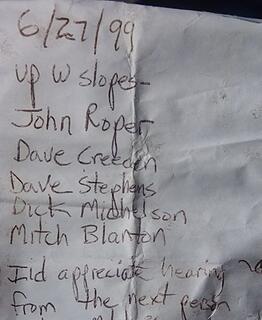 pt7235 register
|
| Back to top |
|
|
Randy
Cube Rat
Joined: 18 Dec 2001
Posts: 2910 | TRs | Pics
Location: Near the Siamangs |
|
Randy
Cube Rat
|
Thu Aug 20, 2020 3:36 pm |
|
|
15 years since I've given this thing a single thought. Obscure.
|
| Back to top |
|
|
|
|


