| Previous :: Next Topic |
| Author |
Message |
Bailey
Member


Joined: 28 Feb 2003
Posts: 2 | TRs | Pics
|
|
Bailey
Member
|
 Fri Feb 28, 2003 11:48 am |
|
|
We're coming from VA to hike some of the wonderful trails in Cascades & Olympic Parks in mid August. The Cascade Pass Trail to Sahale Arm sounds great but is there a big problem with biting flies at that time? Also, we want to take a side trip to Doubtful Lake or Horseshow Basin - which would be best and how long? I'm having trouble finding these details in the books we have. My next question is on Olympic Park - we have heard of but can't find any details on trails that have beach caves. I've heard mention of 3rd Beach and 2nd Beach trails. My last question is on Shi Shi Beach. Heard that a shortcut to the beach involves getting access through private property - do you pay someone to park your car? How long would you allow for this trail? I really appreciate someone taking the time to answer these typical tourist questions! 
|
| Back to top |
  
|
|
Cast K. Pass
Guest
|
|
Cast K. Pass
Guest
|
Fri Feb 28, 2003 12:07 pm |
|
|
For Cascade Pass, I suggest you read reports on www.wta.org. You can search for Cascade Pass trail in the North Cascades region, and see how many complaints there are about flies. Last year was unusually bad for bugs. I was there in late June with no bug problems, lots of snow though. August is a lot different up there than June.
|
| Back to top |

|
|
Ice Girl
Member
Joined: 30 Apr 2002
Posts: 291 | TRs | Pics
|
|
Ice Girl
Member
|
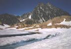
Fri Feb 28, 2003 12:19 pm Horseshoe Basin, Doubtful Lake
|
|
|
i went over Cascade Pass all the way to Stehekin last August, no bugs.
i went to the crest of Shahale, and looked down on Doubtful, long way down to see a lake you can see from the top.
As far as Horseshoe Basin, i spent the whole day there and it was terrific.
Can't see more waterfalls in one place then there, Black Warrior Mine is pretty cool, too. i want to go back and spend a couple days in the basin exploring things.
i have a trip report in the Trip reports here, i believe there is pic there of the whole trip.
Ice Girl
|
| Back to top |
|
|
polarbear
Member
Joined: 16 Dec 2001
Posts: 3680 | TRs | Pics
Location: Snow Lake hide-away |
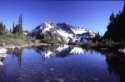
If you are hiking to Cascade Pass, I second Ice Girl's vote on going up to Sahale Arm. It's another couple miles but the views are great. If you are backpacking, I believe they have 6 sites at the base of Sahale glacier with 6 people per site max and you have to get a permit from the Forest Service to camp. I was there for two days in mid-September last year. The bugs weren't bad, but the place has a reputation for bugs, so go prepared.
Some people camp in Peltin Basin which is I think 1/2 mile beyond the pass.
I was able to get a camping permit the morning I went, but as this is a popular place I think either I lucked out or traffic is dwindling by mid-September.
|
| Back to top |
|
|
st
Guest
|
|
st
Guest
|
Sun Mar 02, 2003 6:30 pm shi-shi
|
|
|
I’ve been to Shi-Shi about three times. Once from the south starting at Lake Ozette. This requires a ford of the Ozette River and a long beautiful hike. The other times from Neah Bay. After entering the town you drive through it till you’re almost to the end of the town, than turn left, which would be west. This direction also takes you to the Cape Flattery trails. Just before you reach the coast you go left over a bridge. To get to the Flattery Trails you would go straight a little farther than towards the right. The last time I was there there were signs up and they are now charging for parking. I didn’t pay myself because I was left off there for the day. To go to Shi-Shi continue across the bridge and follow the coast for a ways. Signs will direct you to the Fish Hatchery and you can follow those. At a sharp left-hand turn you’ll see a white steel gate. This will be the access. I was left off here both times for the day so I never had do bother with parking. But the house that takes the money is the last house you past on the left. Large yard with cars parked on north side and fence around it. I talked to people about it but I can’t remember the price right now. After the white gate you follow a long forest road. It’ll get very muddy and very deep and you’ll start to wonder but sooner than later you’ll see a Park Service sign. You turn towards the water here. You can do it easy in one day. I went to the Arches both times from the North, both times in winter.
|
| Back to top |
|
|
Tsolo
Member
Joined: 16 Dec 2001
Posts: 166 | TRs | Pics
Location: Seattle |
|
Tsolo
Member
|
Mon Mar 03, 2003 10:22 pm |
|
|
The bugs usually aren't that bad, at least by the standards of the rest of the country; besides, once you get up on on Sahale Arm there's usually a breeze. Every year seems to be different with regards to bug intensity. IMO, Sahale Arm is one of the more spectacular places in the Cascades.
Doubtful Lake is not worth the descent; there's not much there except a few signs of mining activity, and the views are all up above.
|
| Back to top |
|
|
strider
Member
Joined: 24 Aug 2002
Posts: 464 | TRs | Pics
Location: Silverdale |
|
strider
Member
|
Mon Mar 03, 2003 10:58 pm |
|
|
Bailey,
Shi Shi and Point of Arches is very cool but I think there are other, more scenic areas of the coast. The Third Beach trailhead west of the town of Forks would be my suggestion. Hike description:
From Highway 101 just North of forks, drive West on the road to the villiage of LaPush. About 13 or so miles form 101, you'll find the Third Beach trailhead on the left side of the road.
Trailhead, 1.6 miles to Third Beach.
.5 miles South on beach, to Taylor Point (cannot go around Taylor Pt at any tide).
1.2 mile overland trail over Taylor.
.5 mile beach to Scotts' Bluff (can round at low tide).
.2 mile over Scotts' bluff
1.5 miles to Strawberry Pt. - Very cool cave thru the big headland, which can be negotiated at low tide.
1 mile to Toleak Point.
Campsites where there are creeks supplying fresh water, at South side of Scotts Bluff and at Toleak Point. Great tide pools at any of the points.
If you have the tide in your favor, it's about a 3 hour walk to Scotts', maybe four or more hours to Toleak. If the tide's in the way, the same hike can take twice as long or more. Take a tide table and know how to use it. In August, there's walking light form 5AM to about 9PM, so you can always wait out awkward tides.
This section of the coast is called the Giant's Graveyard, because of all the sea stacks. Extremely pretty. There's a great web site that gives arial views, I'll go fetch the URL and post it for you....
strider
strider
I've never been lost, but I'm frequently uncertain where my destination might be in relation to where I am at the moment....
strider
I've never been lost, but I'm frequently uncertain where my destination might be in relation to where I am at the moment....
|
| Back to top |
|
|
strider
Member
Joined: 24 Aug 2002
Posts: 464 | TRs | Pics
Location: Silverdale |
|
strider
Member
|
Mon Mar 03, 2003 11:16 pm |
|
|
Bailey, here's some URLs for you....
Oly N.P. tourist map of the coast, the area I described is on the lower part of the map.
http://www.forks-web.com/maps/shishihohead.jpg
Here'a a URL to a Wash State Dept of Ecology website that has arial photos of all Wash state coastlines. The URL below will take you to photos of Strawberry Point and the beaches N and S of Strawberry. Click on any photo for larger image, navegate N and S with the arrows, use the HOME link to navigate a graphic map of the whole state. You can find any part of the state's coastline.
http://apps.ecy.wa.gov/shorephotos/scripts/photosearch.asp?id=JEF0772
strider
strider
I've never been lost, but I'm frequently uncertain where my destination might be in relation to where I am at the moment....
strider
I've never been lost, but I'm frequently uncertain where my destination might be in relation to where I am at the moment....
|
| Back to top |
|
|
Bailey
Member
Joined: 28 Feb 2003
Posts: 2 | TRs | Pics
|
|
Bailey
Member
|
Wed Mar 19, 2003 11:20 am Third Beach versus Shi Shi Beach
|
|
|
Thanks for all the great information. I have a question on Strider's comments on Third Beach being perhaps the better choice over Shi Shi Beach. We are hiking with 3 kids ages 9, 12 & 15. We read somewhere that you must climb a couple of steep ladders. The description was pretty vague and we don't know how steep and dangerous the ladder really are. What do you think?
Thanks!
|
| Back to top |
|
|
sarbar
Living The Dream

Joined: 28 Jan 2002
Posts: 8055 | TRs | Pics
Location: Freeland, Wa |
|
sarbar
Living The Dream
|
Thu Mar 20, 2003 2:19 pm |
|
|
 Hehheh...the infamous overland headland rope ladders on the Olymic coast. A thrill they are! Some are just straiht peices of rope, other are more elaborate. Your kids will LOVE it!!!
As for Shi-Sh, I just saw in todays Seattle P-I outdoor notes, that the new trail will be opening up in june or july this year!! The parking lot will be for dayuse only, but like in the old days, you can park your car for a few $$ at the tribal members house ext door. (And I am a firm believer in this!! Support the tribes in this area, they are keeping the area open!! Cape Flattery is def. worth seeing, the Makah Tribe did a lovely job with the trail. The $7 parking fee is well worth it. And, hey, they have ZERO annoying casinos so go!!)
As for biting flies-I was up in Cascade Pass last summer in I think late July, and I got bit like crazy in the woods Hehheh...the infamous overland headland rope ladders on the Olymic coast. A thrill they are! Some are just straiht peices of rope, other are more elaborate. Your kids will LOVE it!!!
As for Shi-Sh, I just saw in todays Seattle P-I outdoor notes, that the new trail will be opening up in june or july this year!! The parking lot will be for dayuse only, but like in the old days, you can park your car for a few $$ at the tribal members house ext door. (And I am a firm believer in this!! Support the tribes in this area, they are keeping the area open!! Cape Flattery is def. worth seeing, the Makah Tribe did a lovely job with the trail. The $7 parking fee is well worth it. And, hey, they have ZERO annoying casinos so go!!)
As for biting flies-I was up in Cascade Pass last summer in I think late July, and I got bit like crazy in the woods  But then agai, so did I about everywhere I went in the Cascades last summer But it was worth it, and once you hit snow, the bugs disapear But then agai, so did I about everywhere I went in the Cascades last summer But it was worth it, and once you hit snow, the bugs disapear 
|
| Back to top |
|
|
The Guy From Bend
Member
Joined: 19 Jun 2002
Posts: 95 | TRs | Pics
Location: Bend, Oregon |
I'd second Tsolo's opinion on Sahale Arm. Absolutely gorgeous up there.
Here's a question: Isn't there a way to get into Horseshoe Basin from Sahale Arm? The last time I was camped by the glacier, I made my way down the east side (east of Doubtful Lake) and found a great overlook of the Basin. I didn't attempt to go much further, but is there a reasonable scramble down there?
|
| Back to top |
|
|
Larry
Member

Joined: 22 Feb 2003
Posts: 1084 | TRs | Pics
Location: Kitsap |
|
Larry
Member
|
Thu Mar 20, 2003 7:10 pm |
|
|
Bailey, here's an "action" shot of Third Beach. 
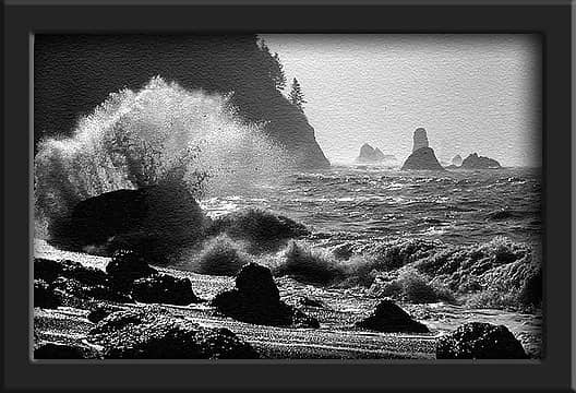 Third Beach Splash
|
| Back to top |
|
|
|
|
You cannot post new topics in this forum
You cannot reply to topics in this forum
You cannot edit your posts in this forum
You cannot delete your posts in this forum
You cannot vote in polls in this forum
|
Disclosure: As an Amazon Associate NWHikers.net earns from qualifying purchases when you use our link(s). |


