| Previous :: Next Topic |
| Author |
Message |
Edd
Member


Joined: 23 Jun 2003
Posts: 296 | TRs | Pics
|
|
Edd
Member
|
 Mon May 01, 2006 9:25 pm |
|
|
I saw a TR not to long ago on cascade climbers that sparked my interest in this peak, mainly because of its close proximity to Sloan. A few weeks ago I headed out in somewhat unsettled weather to mainly check out the route as far as I could go, hopefully following the trench left the previous week. I could not find my altimeter that morning and did not feel comfortable route finding giver the weather without an altimeter to go with my compass and map.
The morning of my previous trip as I pulled out of the mini mart in Darrington I noticed a Subaru heading out of Darrington on the mountain loop hiway. I figured It would pull off somewhere along the way and I would pass it, thinking not to many people would be headed where I was on that particular day. It turned out to be Dicey and Laurie and they were headed exactly where I was, (coincedence). The weather teased us somewhat on the ascent, but as we neared the summit it socked in on us and visibility was nil, (at least for me). I tend to get somewhat apprehensive when I cannot see and do not know what the terrain is like. Also it was very warm and the snow conditions were sketchy as far as avy conditions. Given we had absolutely no views we decided to eat lunch and bag it for another day. I really wanted to see Sloan from there so I definitly was comming back.
Sunday 4-30
Well the weather forcast looked better, but as I drove from Arlington to Darrington it rained pretty heavy. I knew I would't get great weather but I was hoping for some breaks, maybe making for some interesting photo ops, mainly Sloan. There is a good TR on cascade climbers and one here also, from last week, so again, I won't elaborate on the route. I do want to note though that last time with Dicey we headed up through the cliff bands fairly early to gain the ridge, where the boot tread faded at a bunch of down trees. This time though where the path faded I climbed over the downed trees and brush and picked up the path on the other side. Mainly I did this in hope of staying a little drier by avoiding the alder and wet brush we encountered last time. The tread faded quite a bit in places where there had been down trees, washouts ect. I finnally got impatient though and began gaining altitute, to gain the ridge that leads to the gully accessing the northeast slopes below the summit of Bedal. I did though make a mental note to begin my sw traverse long before reaching 2600ft, on my descent if I chose to take the ridge back down. Did get some nice sun breaks on the way up, but by the time I reached the summit (noon), the clouds came in and never left. I spent a little over an hour on the summit waiting for the full view of Sloan but it wasn't to happen. None the less it was a great day to be out. The wind and snow had wiped out any trace of previous visits adding to the solitude and beauty.
Ed
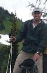
 slopes and valley  shadows  palms  pic  pic 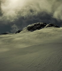 summit 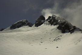 debris  final push  leaving  highlights
|
| Back to top |
  
|
|
Riverside Laker
Member

Joined: 12 Jan 2004
Posts: 2818 | TRs | Pics
|
This is the classic case of the internet spawning lots of use of an area. We went up there a week ago, and found two other parties on the same route. I'll bet this route was rarely done before.
|
| Back to top |
|
|
Edd
Member
Joined: 23 Jun 2003
Posts: 296 | TRs | Pics
|
|
Edd
Member
|
Mon May 01, 2006 9:49 pm |
|
|
Thats true. Thats how I found out about recent conditions, from a thread bump on a TR from last summer. It kind of rekindled my interest in getting back up there.
Ed
|
| Back to top |
|
|
Dayhike Mike
Bad MFKer
Joined: 02 Mar 2003
Posts: 10958 | TRs | Pics
Location: Going to Tukwila |
| RollerPair wrote: | | This is the classic case of the internet spawning lots of use of an area. We went up there a week ago, and found two other parties on the same route. I'll bet this route was rarely done before. |
Yeah, but I don't see any harm in sharing it.
1. Winter travel is probably the closest thing you'll get to leave no trace...no worn vegetation, your footprints just melt away. Only bad news would be trash left behind, but people that are ambitious enough to be getting out in this weather are also smart enough to be good caretakers of the land.
2. The biggest logistical obstacle to overcome is simple access. Most of the good access roads are closed this time of year, which seriously limits the feasible options for a weekend trip. I'm thankful for those who've posted trips and provided ideas for off season trips. Without them, I'd be limited to trips up the Cable Line with Summit22.*
* Not that there's anything wrong with that.
"There is only one basic human right, the right to do as you damn well please. And with it comes the only basic human duty, the duty to take the consequences." -P.J. O'Rourke
"Ignorance is natural. Stupidity takes commitment." -Solomon Short
"There is only one basic human right, the right to do as you damn well please. And with it comes the only basic human duty, the duty to take the consequences." -P.J. O'Rourke
"Ignorance is natural. Stupidity takes commitment." -Solomon Short
|
| Back to top |
|
|
Andrew
Member
Joined: 24 Oct 2003
Posts: 1175 | TRs | Pics
Location: Arlington |
|
Andrew
Member
|
Tue May 02, 2006 1:37 am |
|
|
Lovely compositions and lighting. Great use of lines and shadows too... 
|
| Back to top |
|
|
Riverside Laker
Member
Joined: 12 Jan 2004
Posts: 2818 | TRs | Pics
|
| Quote: | | 1. Winter travel is probably the closest thing you'll get to leave no trace...no worn vegetation, your footprints just melt away. |
The lower several thousand feet were not snow-covered. That path could change from pristine woods to Mailbox Peak type of "trail" with more traffic.
|
| Back to top |
|
|
Oren
Grampa Murphy

Joined: 27 Jun 2004
Posts: 349 | TRs | Pics
Location: Stranger in a strange land |
|
Oren
Grampa Murphy
|
Tue May 02, 2006 10:41 pm |
|
|
Long since I've been amongst majestic peaks
nor side mirrored lakes where awe so speaks.
Blanketed valleys the dawn awakes and blinking stars to fade.
My soul is called to see these things, the Hand of God has made.
|
| Back to top |
|
|
ree
Member

Joined: 29 Jun 2004
Posts: 4399 | TRs | Pics
|
|
ree
Member
|
Wed May 03, 2006 12:04 am |
|
|
Great pictures, EDD!!
|
| Back to top |
|
|
Randy
Cube Rat

Joined: 18 Dec 2001
Posts: 2910 | TRs | Pics
Location: Near the Siamangs |
|
Randy
Cube Rat
|
Wed May 03, 2006 9:02 am |
|
|
Cool.
|
| Back to top |
|
|
yew
non-technical
Joined: 12 Dec 2005
Posts: 1173 | TRs | Pics
Location: Bellingham |
|
yew
non-technical
|
Thu May 04, 2006 8:40 pm The WWW and new use
|
|
|
| Quote: | | This is the classic case of the internet spawning lots of use of an area. We went up there a week ago, and found two other parties on the same route. I'll bet this route was rarely done before. |
I think that's a good thing. Atleast if internet posts tend to spread people out and not condense them into the same old overtrampled places.
Offpoint: I'm new to the North Cascades except for a handful of hikes over the years. For the most part, I only hiked from about Mt Rainier south to Central Oregon. I was surprised at how few trails are in the North Cascades Park and alot of the Glacier Peak Wilderness. There are far more trails through Olympic than North Cascades. Since the federal government, via lack of budgetary priorities, NPS philosophy, Wilderness status, preservationist activist pressure, will not be building trails across North Cascades National Park, that leaves all those big, awesome, craggy peaks only accessible to cross-country hikers and climbers.
To tie that in with your comment: I think it's good that people post cross-country routes on the Web, so other people follow and a good route can be booted in. This can substitute for trails in areas where the government will not build any.
"I aint jokin woman, I got to ramble...We gonna go walkin through the park every day." - Led Zeppelin
"I aint jokin woman, I got to ramble...We gonna go walkin through the park every day." - Led Zeppelin
|
| Back to top |
|
|
|
|


 Great pics EDD