| Previous :: Next Topic |
| Author |
Message |
Jeff R
Closet hiker.

Joined: 10 Apr 2005
Posts: 972 | TRs | Pics
Location: Everret |
|
Jeff R
Closet hiker.
|
 Sun May 07, 2006 2:20 pm |
|
|
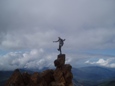
Argonaut Peak.
Elevation-8,453' the 62nd highest peak in Washington.
Stats-12 miles round trip, gain- 5000'+
Route- NorthEast Gully
Gear used- Crampons, helmets, pickets and 50 meter rope. snowshoes not needed.
Party- Stefan F, Mike C, Greg K, Dave C, and Myself.
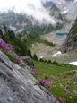
At this time, road #7601 ( access for Colchuck and Stuart lake) can be driven almost to the trail head parking area . A foot of snow over the road stopped all cars 1/8 mile before the trail head sign. The trail to Colchuck lake has been well travelled and is nicely packed down. We walked this with out snowshoes or problems to and past the junction at 2 1/2 miles. At the junction we took the Right fork towards Stuart lake, passing 3 large flat marshy areas going over a couple snow bridges and crossing Mountaineer creek on a log. About a mile from the fork in the trail, we trended to our left keeping the East fork of Mountaineer creek on our right while travelling in a SouthEast direction through open forest staying level at 4600' for some time. After the level section, we started to gain some elevation finally emerging from the trees. Once we were out in the open, we were able to see Sherpa peak to our Right, with Colchuck peak on our Left, and Argonaut peak standing front and center, offering us a full view of our route up the NE couloir.
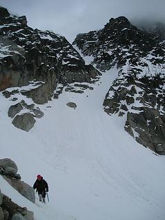 NE Couloir 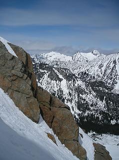 In the NE couloir 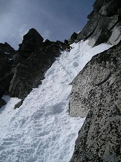 Snow Gully 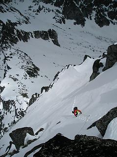 North slope 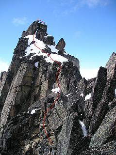 Argonaut Route line 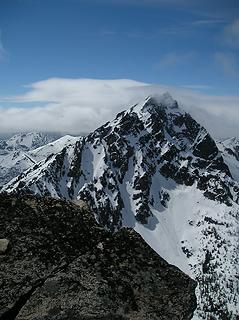 Mount Stuart 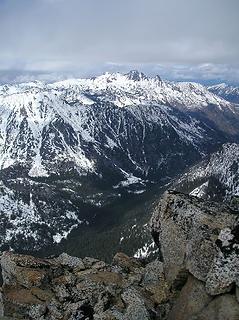 Cashmere, Mountaineer Creek 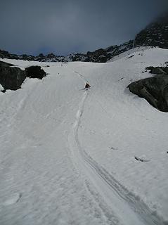 fun way down
|
| Back to top |
  
|
|
wildernessed
viewbagger

Joined: 31 Oct 2004
Posts: 9275 | TRs | Pics
Location: Wenatchee |
Living in the Anthropocene
|
| Back to top |
|
|
Edd
Member

Joined: 23 Jun 2003
Posts: 296 | TRs | Pics
|
|
Edd
Member
|
Sun May 07, 2006 4:17 pm |
|
|
Thanks Jeff. Nice pics, I really like the one looking down on the north slope. 
|
| Back to top |
|
|
l
Member

Joined: 24 Nov 2005
Posts: 1030 | TRs | Pics
|
|
l
Member
|
Sun May 07, 2006 4:45 pm |
|
|
Love the perspective of 'North Slope'. Man, you guys are hard core.
|
| Back to top |
|
|
dicey
custom title

Joined: 11 May 2004
Posts: 2870 | TRs | Pics
Location: giving cornices a wider berth |
|
dicey
custom title
|
Sun May 07, 2006 9:21 pm |
|
|
Nice!
|
| Back to top |
|
|
Dayhike Mike
Bad MFKer
Joined: 02 Mar 2003
Posts: 10958 | TRs | Pics
Location: Going to Tukwila |
Nice pics! Looks like you guys had a great time!
Can you upload a larger version of the one showing the route up?
"There is only one basic human right, the right to do as you damn well please. And with it comes the only basic human duty, the duty to take the consequences." -P.J. O'Rourke
"Ignorance is natural. Stupidity takes commitment." -Solomon Short
"There is only one basic human right, the right to do as you damn well please. And with it comes the only basic human duty, the duty to take the consequences." -P.J. O'Rourke
"Ignorance is natural. Stupidity takes commitment." -Solomon Short
|
| Back to top |
|
|
Tom
Admin
Joined: 15 Dec 2001
Posts: 17857 | TRs | Pics
|
|
Tom
Admin
|
Sun May 07, 2006 11:28 pm |
|
|
| Dayhike Mike wrote: | | Can you upload a larger version of the one showing the route up? |
Click on the "view larger size" link.  Nice shots Jeff. I concur with Ed - nice capture of light and shadow in the pic looking down on the north slope.
|
| Back to top |
|
|
Dayhike Mike
Bad MFKer
Joined: 02 Mar 2003
Posts: 10958 | TRs | Pics
Location: Going to Tukwila |
AHHH...
"There is only one basic human right, the right to do as you damn well please. And with it comes the only basic human duty, the duty to take the consequences." -P.J. O'Rourke
"Ignorance is natural. Stupidity takes commitment." -Solomon Short
"There is only one basic human right, the right to do as you damn well please. And with it comes the only basic human duty, the duty to take the consequences." -P.J. O'Rourke
"Ignorance is natural. Stupidity takes commitment." -Solomon Short
|
| Back to top |
|
|
ActionBetty
Im a dirty hippie!

Joined: 06 Jul 2003
Posts: 4807 | TRs | Pics
Location: kennewick, wa |
|
ActionBetty
Im a dirty hippie!
|
Mon May 08, 2006 8:30 am |
|
|
Sweet!
"If you're not living good, you gotta travel wide"...Bob Marley
"If you're not living good, you gotta travel wide"...Bob Marley
|
| Back to top |
|
|
Stefan
Member

Joined: 17 Dec 2001
Posts: 5093 | TRs | Pics
|
|
Stefan
Member
|
Mon May 08, 2006 8:45 am |
|
|
thanks for doing the trip report Jeff!
Anyway, instead of downclimbing that gulley....I would recommend you rappel over towards Colchuk and traverse over to Colchuk col. Downclimbing takes too long!
|
| Back to top |
|
|
Jeff R
Closet hiker.

Joined: 10 Apr 2005
Posts: 972 | TRs | Pics
Location: Everret |
|
Jeff R
Closet hiker.
|
Mon May 08, 2006 2:14 pm |
|
|
Everyone, thanks for your positive comments!
"Downclimbing takes too long!"
I agree. Unfortunately, the snow conditions in the gully were not conducive for a stylish standing glissade.
|
| Back to top |
|
|
kycooyo
Member
Joined: 07 Mar 2006
Posts: 163 | TRs | Pics
|
|
kycooyo
Member
|
Mon May 08, 2006 3:28 pm |
|
|
Awesome TR and quite and achievement I must say!  Just wondering, did you happen to snag any pictures of the Ingalls Creek valley from up there? I'm considering doing an overnight there in a couple of weeks... just wanted to see what the snow is like. Thanks.
|
| Back to top |
|
|
Jeff R
Closet hiker.
Joined: 10 Apr 2005
Posts: 972 | TRs | Pics
Location: Everret |
|
Jeff R
Closet hiker.
|
Mon May 08, 2006 4:00 pm |
|
|
kycooyo,
Sorry, I did not take any pictures South of the peak. My only excuse was that any taken would have been washed out since it would be facing the sun. But, regarding a snow conditions/ beta stand point, I should have and will in the future.
Beverly/turnpike and Longs pass are still very snowy. If you start the trail from Highway 97, you should be able to go quite far up the valley.
|
| Back to top |
|
|
ShawnAintny
Member

Joined: 20 Oct 2005
Posts: 31 | TRs | Pics
Location: East Side, Greenacres |
Wow! I want to be you when I grow up! You guys really live!
|
| Back to top |
|
|
|
|


 , great reading and pics.