| Previous :: Next Topic |
| Author |
Message |
Slugman
Its a Slugfest!


Joined: 27 Mar 2003
Posts: 16874 | TRs | Pics
|
|
Slugman
Its a Slugfest!
|
 Tue Apr 01, 2003 10:08 am |
|
|
FS rd #23 has snow starting about two miles from the trailhead. Just beyond the crossing of Owl Creek, my Subaru wagon started to high-center on the packed slush. I backed up and parked at Owl Creek. A vehicle with good clearance could definitely make it to the end. I walked the 1 1/2 miles to the trail in 45 minutes. The giant trees and wilderness feel begin right away, even though the wilderness boundary is reached after another 1/2 mile. Next comes Fire Creek at one mile of trail. Just after you cross the bridge, turn left on a small path-let to see a great view of the falls. At 1 1/2 miles from the trail start, at a section of cliff-up on the left and cliff-down on the right, I came to a vicious blow-down that totally wipes out the trail. One giant tree has taken out several smaller ones, too. I managed to snake through at the cost of getting filthy with mud, etc. The trail has also slid down into the river below just a few feet beyond the blow-down. There was a faint path about two inches wide crossing the slide, but it looked too risky for me. I wormed my way back through the log pile and found a cairn leading to an apparent bypass up and over the blockage. When I reached the top, I found the whole flat area to be a tangled mass of downed trees and uprooted stumps, etc. It would be passable to the nimble or the determined, but having gone over three miles already, I called this my turn-around and headed back. After returning to the car, I checked out the road signed "Meadow Mtn 3 miles". After two miles there is a landslide blocking the road for anything other than the most agressive, high-clearance 4wd's.
I lucked out on this hike since it rained all the way there in the car, and started raining again just after reaching the car, but I had no rain while hiking from 10 am to 6 pm. The White Chuck trail itself had only intermittent snow, high boots or gaiters only were needed.
|
| Back to top |
  
|
|
McPilchuck
Wild Bagger

Joined: 17 Dec 2001
Posts: 856 | TRs | Pics
Location: near Snohomish, Wa. |
I almost went up the White Chuck again the same day as you, been going up that way most all winter on photo outings around White Chuck Mtn. However, opted to go up by Silverton instead...got a beautiful rainbow shot
of Boardman Creek Valley from above near Boardman Lake area. Incidentally, the road to Boardman has snow about a mile from the Trailhead. Mallardy Ridge road has snow at 5 miles up near landing. Ashland Lakes road snow at Y before Black Creek Crossing/Bear Lake Trailead Road. Sunrise Mine/Vesper has snow before first creek crossing. All are not even doable with 4x4 yet.
McPil
|
| Back to top |
|
|
Slugman
Its a Slugfest!

Joined: 27 Mar 2003
Posts: 16874 | TRs | Pics
|
|
Slugman
Its a Slugfest!
|
Tue Apr 01, 2003 6:15 pm |
|
|
McPilchuck,
Do you have any info on the road to the Walt Bailey trail to Cuthroat Lakes? I was there last summer and I can't wait to go back.
|
| Back to top |
|
|
Karen
Member

Joined: 22 Dec 2001
Posts: 2866 | TRs | Pics
|
|
Karen
Member
|
Tue Apr 01, 2003 6:25 pm |
|
|
I enjoyed the post about White Chuck area -- makes me want to return even though it doesn't sound like conditions were as good as when I took this image, last May.
Karen
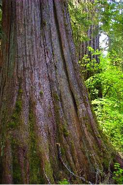 white ck big cedar
stay together, learn the flowers, go light - from Turtle Island, Gary Snyder
stay together, learn the flowers, go light - from Turtle Island, Gary Snyder
|
| Back to top |
|
|
McPilchuck
Wild Bagger
Joined: 17 Dec 2001
Posts: 856 | TRs | Pics
Location: near Snohomish, Wa. |
Slugman,
The Walt Bailey/Cutthroat Lakes Trailhead Road is snowed up at about 5 miles up from the highway, on the shaded east side of the hill just before the landing near the old Mallardy Ridge Trail. It's not yet passable in 4x4 mode as I tried it, and I have driven the Pilchuck L.O. Road in the dead of winter to the parking lot with 5.5 out of the 7.5 mile road in snow, for snow climbs to the mountain top. I would say tho, the snow on the road will go fast as it has no real pack, perhaps a few weeks baring any new snow and you'll be able to drive right to the trailhead of the Cutthoats...Walt Bailey Trail.
McPil
|
| Back to top |
|
|
Ulrich
Member
Joined: 02 Feb 2002
Posts: 174 | TRs | Pics
Location: Seattle |
|
Ulrich
Member
|
Sat May 31, 2003 6:48 am |
|
|
Hiked the White Chuck River trail yesterday, another beautiful forest hike on our spring list. Trail with the exception of a re-routed area at 2 miles- parts of it steep and narrow and when muddy or wet probably somewhat difficult to manage- without any obstacles. It appears that a new bridge has been placed before reaching the hot spring. No other foot traffic except 2 climbers in the afternoon on their way to Glacier Peak. Some snow patches starting behind the hot spring. Weather remained mild all day. The rain didn't hit us until we passed through Darrington.
|
| Back to top |
|
|
|
|
You cannot post new topics in this forum
You cannot reply to topics in this forum
You cannot edit your posts in this forum
You cannot delete your posts in this forum
You cannot vote in polls in this forum
|
Disclosure: As an Amazon Associate NWHikers.net earns from qualifying purchases when you use our link(s). |


