| Previous :: Next Topic |
| Author |
Message |
dean brittain
Member


Joined: 22 Feb 2003
Posts: 56 | TRs | Pics
Location: seattle |
My wife and I left Ballard early Saturday hoping for decent weather in the North Cascades. We hit a couple of light snow flurries before Diablo Lake en route to the trailhead. It felt good as always to see no cars at the parking lot. We have minimal winter gear so crossing some of the creeks were difficult. About 6 in all had to be carefully negotiated(without getting our feet wet). The trail is in good shape all the way to Mcallister Camp, our destination for the night. Nice views of Colonial And Snowfield Peaks from the trail. Hardly any snow left at all to this point. Saw only one other party passing thru the camp. The rest of the time we had it to ourselves. It's a long drive but, this is a great spring weekend trip.
Mcallister Camp provides lots of privacy. There are 5 spots in all, which are very spread out along Thunder Creek. The first spot is the best. It has a nice gravel bar and a small waterfall flowing in the creek across from the site. Did I mention it only started to rain once we got back to the car on Sunday?
|
| Back to top |
  
|
|
Slugman
Its a Slugfest!

Joined: 27 Mar 2003
Posts: 16874 | TRs | Pics
|
|
Slugman
Its a Slugfest!
|
 Mon Apr 07, 2003 11:35 pm |
|
|
Dean,
Have you ever been farther up this trail? I notice from my topo software that if you go up about 11 miles, you could head off-trail up Skagit Queen Creek and get an outstanding view of Boston Glacier, filling up a giant bowl two miles wide and one high. There is an old mine marked on the map, so there might even be a trail of some sort. If anyone has been up there, or tried to go and couldn't, let me know as I would like to plan a three or four day excusion there for later this summer.
|
| Back to top |
|
|
Bushwacker
Comfortable

Joined: 28 Jun 2002
Posts: 834 | TRs | Pics
Location: Chaweng Beach, Koh Samui, Thailand |
Sounds like a great hike.
Mountain views, waterfalls, solitude.
You can't beat that.
Been looking into doing a trip there this season.
Possibly later in the summer, but it sounds like early works better for some solitude. I've heard it can get crowded.
BTW, any spots for possible off-trail work?
BW
"Wait by the river long enough and the bodies of your enemies will float by"...Sun Tsu
"Wait by the river long enough and the bodies of your enemies will float by"...Sun Tsu
|
| Back to top |
|
|
Karen
Member

Joined: 22 Dec 2001
Posts: 2866 | TRs | Pics
|
|
Karen
Member
|
Tue Apr 08, 2003 8:48 am Thunder Creek and the Scouts
|
|
|
A few years back my ex-husband (a Scout Master at that time) and I went up to Thunder Creek one February and camped overnight at McAllister Camp. There was NO snow and we had a great time. No one else around the entire weekend. We were amazed that no one else was out and about. It's amazing how many people don't go out in the winter because they don't think there are places to go. Many trails can be hiked in the winter and early spring even though the hiking guides write them up as trails to be hiked later in the year. This is the best time of the year for beauty and solitude. A lot of people don't even START hiking until Memorial Day and then they stop hiking Labor Day weekend. I don't get it.
Prior to that I have been further up the Thunder Creel trail. My friend Kathe and I spent three days up there a few summers ago. We camped at Neve Camp the first night and the camp beyond McAllister Camp the second night (I don't remember the name of that camp). On our third day we hiked up as far as we could and got to Thunder Creek past the cabin. We passed the Skagit Queen mine which is near the trail -- a lot of timbers and odds and ends. It's a wild and lonesome place. Even in the middle of summer there was no one up there. I recall we met only one other backpacker the entire 4-5 days we were out there.
Karen
stay together, learn the flowers, go light - from Turtle Island, Gary Snyder
stay together, learn the flowers, go light - from Turtle Island, Gary Snyder
|
| Back to top |
|
|
Erik the Nav
Member
Joined: 07 Jan 2002
Posts: 197 | TRs | Pics
|
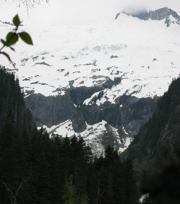
Spent a couple nights this weekend at Junction Camp, nine or ten miles up Thunder Creek. A nice peek through the trees view of Boston Glacier from there, and other outstanding views from my tent. Some of the 'little slice' views were very frustrating throughout the trip - in that it was hard to be sure what I was seeing, lacking enough referents to say "if that's that peak, then this one is.." I'm looking forward to comparing my pics and memories with vol. II of Beckey and some more maps.
Whatever it all was, it was gorgeous.
Sunday, went up to Skagit Queen camp, 'bout four miles past Junction Camp. No real views from Skagit Queen Camp itself, though a mighty nice watefall by the trail just before it.
From there, followed the way trail about a mile further up Skagit Queen. Lovely trail, too, best stretch of the trip. There's a long run of old broken up steel pipe, about 4" dia, running along this trail. Water down to a powerhouse? I don't know. In a backwards way, I did some web searching on Skagit Queen Mine tonight after getting home. The mine marked on (some) maps is up much further than I went, and I could find no more details about it online - at least, not in terms of where to look for ruins. I looked around Skagit Queen Camp a fair bit, and didn't see anything.
The way trail started getting pretty lame pretty fast after about a mile - a piece of trail, some slide alder w/ devil's club spice, a piece of trail, a downed tree thrashpile, ah, more trail - and when I got to a log with a bit of flagging on it across the creek, and it was getting late and I realized my headlamp was in my tent and I could see that I needed to go another mile for it to really get better, well, that was the turn around point.
Attached picture is the view from my turn-around. Seems like the next goal to get to would be past the 'gates' formed by the two ridges in the foreground left and right of the picture.
Looking at the map here:
http://www.topowest.com/Washington/48121/frameo48121e1.125.png.html
it seems like the approach to the mine could be up the draw on the left, before that left/east ridgeline, before going through the 'gate.' I'd have to look some more at pics and better maps to be very confident.
I did find this:
http://www.nps.gov/noca/adhi-10a.htm
"It had been nearly seventy years since the area had been "improved" for mining. In the first decade of this century, the Skagit Queen Consolidated Mining Company and later the British Mining Company set up mining operations. Surface developments included a power house, a barn, assay office, pumphouse, and machine shop, among other structures. Subsurface developments were never as impressive as those on the surface, but they did include a 670-foot crosscut adit. The operation itself, however, proved less successful than the construction of the mining facilities. By 1915 the mine owners had patented most of the property, most likely with the intent of selling out, and subsequently abandoning the developments to the elements. "
There's gotta be some of that left, indeed, and I'd think some tailings to orient on to find the adit?
I think a worthy trip in to look into it deeper.
I'm also looking forward to a lunch date with the First Lady soon, where she promises to show me on maps how far she got on a traverse North from Eldorado, which was intended to come out on Thunder Creek somewhere. I don't remember why they turned back, but from the views I got looking west at all those summits and glaciers, it sounds like a truly awesome trip..
I'd certainly be interested to hear more from anyone who knows more details about Skagit Queen Mine.
 BostonGlreduced
|
| Back to top |
|
|
Larry
Member

Joined: 22 Feb 2003
Posts: 1084 | TRs | Pics
Location: Kitsap |
|
Larry
Member
|
Tue Jun 03, 2003 5:48 am |
|
|
This is a great approach to the Red Mountain area as well. The traverse from Red to Mesahchie is a truly awesome trip in beautiful, remote country.
|
| Back to top |
|
|
Erik the Nav
Member
Joined: 07 Jan 2002
Posts: 197 | TRs | Pics
|
OK, Larry, dish - that a relatively easy traverse? Looks like it could be - that is, easy=not technical. Any tricks to it? Better one way or the other? Tips on where for ford Fisher at the Red Mountain end? (I just saw a bit of Fisher Ck up there - maybe it's not so hard to find a likely spot, and of course it'll get slower later in the season..)
Piques me curiosity because it -does- look like a good traverse, from what I saw of the ridgeline it could be easy rambling, and because I'm tempted to want to go back in to Skagit Queen with more time to explore - but I'd hate to do Thunder Creek again so soon - I want new routes. Any reason not to do that traverse from Easy Pass?
|
| Back to top |
|
|
smokeydon
Member

Joined: 20 Apr 2002
Posts: 56 | TRs | Pics
Location: Everett, Wa. |
|
smokeydon
Member
|
Tue Jun 03, 2003 7:01 pm views of Boston/ easy traverse ?
|
|
|
I have been up the Skagit Queen camp route and went a ways up with no views of the Boston Glacier. From what I remember there were lots of trees and NO VIEWS. I am sure if one proceeded far enough they would eventually break out of the trees (only to be in thick brush !).
As for the EASY traverse of RAGGED RIDGE, the map is very misleading. Not to say that the traverse is not doable, just that it is not a walk in the park. The name Ragged Ridge implies just that, RAGGED ! With that being said, it is most definitely a beautiful and remote area. So infrequently visited that on a recent outing (2002) up Cosho and Kimta peaks the original summit register with John Ropers first ascent was still present. I dont think it matters which direction one would start from, although a one way trip would best be served from Easy Pass due to the higher starting elevation.
|
| Back to top |
|
|
Erik the Nav
Member
Joined: 07 Jan 2002
Posts: 197 | TRs | Pics
|
Past Skagit Queen camp maybe a mile of trail max and then just tops a couple hundred yards of not really that much brush (though it's growing fast), drop down to the bank of the creek, and there's the view I posted above. Which was a better view than that cropped and shrunk picture lets on...
|
| Back to top |
|
|
Larry
Member
Joined: 22 Feb 2003
Posts: 1084 | TRs | Pics
Location: Kitsap |
|
Larry
Member
|
Wed Jun 04, 2003 1:32 pm |
|
|
Three of us did the traverse in (approximately) 1985, when we were "on a roll" having just traversed the Pickets and had 6 days left. Those were the days! It seems that we were in such good shape then that we could just go forever...probably a LOT of us remember those kinds of summers. GREAT memories.
Left a car at Easy Pass trailhead and came in via Thunder Creek. We were inspired by reports from the Fireys (local mountaineers and cross-country mavens).
Here's some data from memory, don't have a map handy at present. If anyone wants a marked map, just yell.
Entered from the Rock Cabin Avalanche and followed to the right of an avalanche fan. I remember it was a long freaking hillside, and we hit the crest of the eastern part of "Red Mountain". So, we didn't technically really do a complete traverse of Red Mountain the way the Firey's did, by any account. With more days available, I think it looked like it was very do-able.
Dropped into the north slopes at some "benching" and then followed the terrain eastward, going up and down where necessary to get around obstacles. Lots of small active glaciers, and absolutely stunning terrain. We lucked out on the bugs..they had just died off from several freezing nights. This was just before Labor Day, about the last days of August, first days of September.
There was a small lake in there that drained into a large lake that we could see below in the lower basin. We had a wonderful time in there, and it was such a remote place and extremely beautiful. Absolutely breathtaking.
We ended up traversing the Kimtah Glacier, and then followed the west Katsuk down to the interglacial terrain. There was a big basin at the head of Panther Creek that we curled around, and then climbed the far eastern end of the Mesahtchie Glacier to crest the ridge and then traversed steep slopes that were pretty good going, to the Easy Pass Trail near Easy Pass.
We still had a full day left, and so took a trip over to Silent Lakes (awesome, awesome, awesome) via the Fisher Creek basin. We could have SWORN that a bear in there we saw was a Grizzly, but couldn't quite get close enough to verify if it truly had a "dished" nose. Sure had the "hump" though...but we realized this wasn't enough to actually verify anything. Anyway, I remember giving it a wide berth!
Gosh...I need to get a map and re-live this...good memories indeed.
Also....I remember the Northern Lights were just wonderful on this trip.
One more thing...another fantastic traverse in the area: Spectacular Ridge via North Fork Bridge Creek and Fisher Creek, with a finish via Wing Lake. This was such a memorable trip, and one more spot where we watched the Northern Lights from Spectacular Ridge. We had attempted a climb of Mt. Logan, but the glacier was horrendously dangerous.
This was a trip where my partner almost died from eating too fast and getting food caught in his airway. Several successive Heimlich maneuvers didn't work, and he was REALLY panicking. (So was I, internally). Finally, his own gag reflexes as he was turning blue (really) dislodged the obstruction. What a terrible thing that was. Needless to say, we both were careful in eating the rest of the trip. Something we should all think about, especially if we are really exerting and are ravenously hungry...it's easy to forget to eat dainty...
|
| Back to top |
|
|
|
|
You cannot post new topics in this forum
You cannot reply to topics in this forum
You cannot edit your posts in this forum
You cannot delete your posts in this forum
You cannot vote in polls in this forum
|
Disclosure: As an Amazon Associate NWHikers.net earns from qualifying purchases when you use our link(s). |


