| Previous :: Next Topic |
| Author |
Message |
Sore Feet
Member


Joined: 16 Dec 2001
Posts: 6307 | TRs | Pics
Location: Out There, Somewhere |
I finally got out this year, though I think I may have over done it for the first major hike of the season. As most people know, the Eagle Creek trail in the Columbia River Gorge is one of the most famous and popular in the area. And prior to this last weekend, I had never done it (I know I know). Original goal was to hike to the furthest waterfall, that being an unnamed falls about 6.2 miles from the trailhead, just above Crossover Falls.
However, because I didn't hit the trail until 1-ish (because I tried to make up for not getting to Multnomah Falls, et. al. the previous day on the morning of the hike), I wasn't able to make it all the way up (sob).
Got to the trailhead around 1, and had to park near the Fish Hatchery because the parking lot was literally over flowing with cars. This lengthened the hike by about 1/4 mile. Once on the actual trail, things got scenic really quickly. Ephemeral waterfalls appeared almost immediately, and maybe 5 minutes into the hike, the trail does it's first cliff-side traverse (though not all that high above the creek). About 1 mile in, the trail starts climbing along a long blasted ledge, above a large rock slide. Along almost the entire length of this ledge, water was dripping and spraying down on to the trail, giving a much welcomed shower (it was almost 70 degrees out). Across the valley is the first major tributary waterfall (Wauna Falls), though it's about 95% hidden by trees (picture is available on my site, I didn't feel it worthy to post here).
The trail then levels out a bit, about 150 feet above the creek, and around 1.5 miles come to the Metlako Falls viewpoint. The falls are a bit distant, but still quite impressive, dropping (apparently) 108 feet into a big bowl. Sorenson Falls is immediately to the left of Metlako that's practicly impossible to see thanks to trees.
Returning to the trail, it crosses Sorenson Creek and intersects the Lower Punch Bowl Trail in another 1/4 mile. This spur drops steeply to the rocky beach between Lower Punch Bowl and Punch Bowl Falls, the site of many many professional photographers' (wet) dreams. Being a beautiful, warm day, it was of course the standard hiker-mecca. And I did, of course, wade out into the #@%!$% freezing water to get the obligatory shot of Punch Bowl Falls (it's being developed), though the water was so !%#@%#$ cold, that I didn't bother with the tripod.
Back on the trail, after stopping at the upper viewpoint for Punch Bowl Falls for more obligatory pictures, I hauled on to High Bridge. The area around High Bridge is pretty cool. Loowit Falls sheets down the gorge wall a short distance downstream, while a small fall on Eagle Creek drops right next to it. Just upstream is a big, deep pool that looks like something you'd see cliff-divers jumping into (and with the trail straight above it, who knows, maybe it's happened). Then the trail bends a hard 90 degrees and you get a good view of the 100 foot deep gorge below High Bridge. Just before crossing the bridge is a big talus field with pretty cliffs above. And then just after the bridge is another pretty scene along Eagle Creek. I could have spent a lot of time photographing this area if I had time. But no, I was here for waterfalls, so on I went.
Next stop, after discounting the little drip passed of as Benson Falls by "A Waterfall Lover's Guide to the Pacific Northwest" (actually there looked to be a really tall fall upstream, but it's probably impossible to get to) was Skoonichuk Falls. Quite impressive, but a little hard to see. There's several nice camp sites in this area, though the thundering falls next door would make it a little difficult to fall asleep.
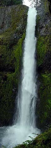
At the 4 1/2 mile mark, the trail crosses back over Eagle Creek on 4 1/2 mile bridge (duh), and follows another blasted ledge section (not high, but still cool). Small Tenas Falls is seen shortly after the bridge. By this time it was nearing 4:00, three hours after starting, and with light fading around 6:45, I vowed to turn around at 4:30 no matter what. By 4:05 I was at Wy'east Camp, and shortly after was impressive Wy'east Falls dropping about 130 feet off a cliff to the left of the trail. Being that Tunnel Falls and Crossover Falls (the two best falls of the trail) were almost another mile in, I decided to take a little time at Wy'east, then head back. Total distance from the trailhead, about 5.2 miles.
Looking back, I know I could have made it all the way to Crossover Falls, and I did have a light with me so hiking in the dark wouldn't have been a problem, but by the time I made it back to the car, my feet hurt so bad I could barely even drive. I was practicly limping because my left achiles tendon was so sore. Guess that'll show me for hiking 10 1/2 miles without a warm up hike or two before hand.
Pics:
(Everything but the Metlako and Loowit pics were taken with an ooooold digital cam that I borrowed from a friend, so excuse the low quality).
Metlako Falls
Lower Punch Bowl Falls
Loowit Falls
Talus Field before High Bridge
Gorge downstream of High Bridge
Gorge upstream of High Bridge
Skoonichuk Falls
Tenas Falls
Wy'east Falls
Shrooms!
Flowers (Yellow Trillium?)
|
| Back to top |
  
|
|
MCaver
Founder

Joined: 14 Dec 2001
Posts: 5124 | TRs | Pics
|
|
MCaver
Founder
|
 Tue Apr 01, 2003 11:01 pm |
|
|
A photo of Punchbowl Falls from this hike by David Muench I saw when I lived in Texas led to me taking a vacation up here, and ultimately to me moving here. Aside from being a classic punchbowl waterfall, for this reason it will always have a special meaning for me.
|
| Back to top |
|
|
Sore Feet
Member
Joined: 16 Dec 2001
Posts: 6307 | TRs | Pics
Location: Out There, Somewhere |
Well then, I'll let you know when I get my pics of Punch Bowl back. 
|
| Back to top |
|
|
Dean
(aka CascadeHiker)

Joined: 02 Mar 2002
Posts: 1967 | TRs | Pics
Location: ex Kennewick, Wa & Lehi Utah |
|
Dean
(aka CascadeHiker)
|
Wed Apr 02, 2003 6:56 am |
|
|
|
| Back to top |
|
|
Sore Feet
Member
Joined: 16 Dec 2001
Posts: 6307 | TRs | Pics
Location: Out There, Somewhere |
|
| Back to top |
|
|
Ice Girl
Member

Joined: 30 Apr 2002
Posts: 291 | TRs | Pics
|
|
Ice Girl
Member
|
Sat Apr 05, 2003 9:59 am |
|
|
Good pics,
The girls and i were going to go to the gorge this weekend, then down to Seaside for the week, (Spring Break). But i have been sick and the doctors said i couldn't go anywhere this week. Bummer...
But we will save it for another day.
Ice Girl
|
| Back to top |
|
|
MooseAndSquirrel
Member
Joined: 10 Nov 2002
Posts: 2036 | TRs | Pics
|
That darn log lying diagonally in front of Punchbowl Falls has got to go!! I too saw a Muench or like photo of that fall (before the tree fell inconveniently in front) many years ago that spurred me on to get down to that trail but was bummed when I came upon that log messing up my photo-shoot  . I didn't get more than a couple miles up the trail that day (it began to rain hard on me) but I'd have to say Punchbowl & Metlako were my favorite falls. I went midweek in May and saw only a woman and child in the couple hours I was photographing. I'm definitely going back- what a gorgeous area! I did try to digitally remove the log from the picture but I'm not patient or skillful enough to do a decent enough job. (used PhotoExpress) . I didn't get more than a couple miles up the trail that day (it began to rain hard on me) but I'd have to say Punchbowl & Metlako were my favorite falls. I went midweek in May and saw only a woman and child in the couple hours I was photographing. I'm definitely going back- what a gorgeous area! I did try to digitally remove the log from the picture but I'm not patient or skillful enough to do a decent enough job. (used PhotoExpress)
|
| Back to top |
|
|
Sore Feet
Member
Joined: 16 Dec 2001
Posts: 6307 | TRs | Pics
Location: Out There, Somewhere |
Digitally removing that log would be a task. I'm hoping that the water will get low enough in the late summer that walking upstream and getting in front of the log would be an option, but the water looked pretty damn deep there, so I don't know 'bout that.
Unfortunately, I doubt that log is gonna move any time soon (if at all).
|
| Back to top |
|
|
MooseAndSquirrel
Member
Joined: 10 Nov 2002
Posts: 2036 | TRs | Pics
|
Punchbowl Falls in spring '98 with log digitally removed. Copy of a copy so quality not the greatest. Looks like I took it from exactly the same spot as you Sore Feet. I kinda felt bad for about 10 seconds because you have to scramble down a steep hillside along the trail to reach the water's edge for this view- no real side trail existed when I was there. I think you're right as well about the water getting pretty deep near the log if one felt adventurous enough to wade out in that cold water- maybe float out on an inner tube or small raft? Of course stability for slow shutter speed needed for silky waterfall pic would be doubtful. That particular angle we used is one of the best photographically IMO- I liked the feeling of peering in past the rocks into the waterfall & its pool. Anyway, unless you knew that log was there and didn't enlarge the pic greatly the retouching is passable. The Iraqis wouldn't want me working on Saddam's fake photos though 
|
| Back to top |
|
|
Sore Feet
Member
Joined: 16 Dec 2001
Posts: 6307 | TRs | Pics
Location: Out There, Somewhere |
Not a bad job. I have no doubt that I'd be able to remove it well, but I don't think I'm gonna bother until I get a shot with a slower shutter speed to do it with (a fellow waterfall-nut friend of mine from Vermont is probably gonna come visit next year, and he'll insist on hiking Eagle Creek, I'm sure).
|
| Back to top |
|
|
Jill
Got Rock?

Joined: 12 Sep 2002
Posts: 229 | TRs | Pics
Location: Vancouver |
|
Jill
Got Rock?
|
Sat Apr 12, 2003 10:11 pm |
|
|
Went Today, Awesome! Only went this far though...
 Tunnel-Falls
"Security is mostly a superstition. <snip> Life is either a daring adventure or nothing at all." Helen Keller
"Security is mostly a superstition. <snip> Life is either a daring adventure or nothing at all." Helen Keller
|
| Back to top |
|
|
Sore Feet
Member
Joined: 16 Dec 2001
Posts: 6307 | TRs | Pics
Location: Out There, Somewhere |
|
| Back to top |
|
|
-florida
Guest
|
|
-florida
Guest
|
Sun Apr 13, 2003 4:56 pm |
|
|
Ah, More the reason to go back!
|
| Back to top |

|
|
|
|
You cannot post new topics in this forum
You cannot reply to topics in this forum
You cannot edit your posts in this forum
You cannot delete your posts in this forum
You cannot vote in polls in this forum
|
Disclosure: As an Amazon Associate NWHikers.net earns from qualifying purchases when you use our link(s). |


 Eagle Creek trail is one of the best in Northwest.


 (Punch bowl, Tunnel Falls, and Cross over falls)
Gotta do this one every year
(Punch bowl, Tunnel Falls, and Cross over falls)
Gotta do this one every year 