| Previous :: Next Topic |
| Author |
Message |
b00
Member


Joined: 29 Sep 2003
Posts: 1144 | TRs | Pics
|
|
b00
Member
|
 Wed Oct 18, 2006 2:16 am |
|
|
golden horn + tower mt 10/11/06-10/13/06
what a great way to end the season - a larch filled trip, in open country, with views that stretch forever. We even got a chance to join in on tower mts celebration: millions of years of loose rock :>)
a moderate start time brought us to the rainy pass trailhead from which we headed up to cutthroat pass on the easy trail
 moon over the crest trail  silver star viewed from cutthroat pass 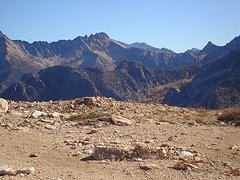 snagtooth is from left to center 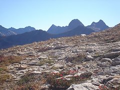 liberty bell from cutthroat pass  tower and golden horn  tower 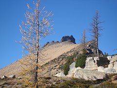 golden horn 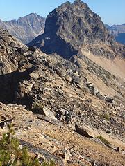 tower mt viewed from golden horns se ridge  golden horn viewd from the ridge  climbed up the notch in the center and traversed right to the summit  tower mt views from the summit of golden horn  tower and golden horn
|
| Back to top |
  
|
|
Backpacker Joe
Blind Hiker

Joined: 16 Dec 2001
Posts: 23956 | TRs | Pics
Location: Cle Elum |
Why didnt you post any pictures?  Great job.
"If destruction be our lot we must ourselves be its author and finisher. As a nation of freemen we must live through all time or die by suicide."
Abraham Lincoln
"If destruction be our lot we must ourselves be its author and finisher. As a nation of freemen we must live through all time or die by suicide."
Abraham Lincoln
|
| Back to top |
|
|
ActionBetty
Im a dirty hippie!

Joined: 06 Jul 2003
Posts: 4807 | TRs | Pics
Location: kennewick, wa |
|
ActionBetty
Im a dirty hippie!
|
Wed Oct 18, 2006 7:59 am |
|
|
Great job on posting ALL of your pics.....nice TR 
"If you're not living good, you gotta travel wide"...Bob Marley
"If you're not living good, you gotta travel wide"...Bob Marley
|
| Back to top |
|
|
Tazz
Member

Joined: 27 Apr 2005
Posts: 7902 | TRs | Pics
|
|
Tazz
Member
|
Wed Oct 18, 2006 8:03 am |
|
|
great beta shots B00! Thanks
|
| Back to top |
|
|
wildernessed
viewbagger

Joined: 31 Oct 2004
Posts: 9275 | TRs | Pics
Location: Wenatchee |
Living in the Anthropocene
Living in the Anthropocene
|
| Back to top |
|
|
Randy
Cube Rat

Joined: 18 Dec 2001
Posts: 2910 | TRs | Pics
Location: Near the Siamangs |
|
Randy
Cube Rat
|
Wed Oct 18, 2006 11:07 am |
|
|
Thanks for the detail b00!
|
| Back to top |
|
|
Sabahsboy
Member

Joined: 18 Jul 2006
Posts: 2484 | TRs | Pics
Location: SW Sno County |
|
Sabahsboy
Member
|
Wed Oct 18, 2006 8:24 pm Golden Horn et al
|
|
|
Photo #35. What is that mountain? I recall seeing it and never figured out what it was...with all those spires and towers. What does it look like from the north side facing south? Does anyone know?
This TR is a great adventure. Thank you for both report and wonderful photos. Now, you have a winter's chore ahead: label the photos! I found Mt. Goode's great slab face and was confused by Logan and think I know Black. The North Cascades viewed from the NE and north delivers many dramatic summits, ice and ridges.
Sure wish I had gone the PCT to Golden Horn; I visited Cutthroat Pass many times for larch viewing and "messing around" on the rocks and frenzy of picture taking.
Now you show me what I missed and more: what I would never have attempted! Thank you for the TR and I can't wait for more of your future adventures.
|
| Back to top |
|
|
Sabahsboy
Member
Joined: 18 Jul 2006
Posts: 2484 | TRs | Pics
Location: SW Sno County |
|
Sabahsboy
Member
|
Wed Oct 18, 2006 8:24 pm Golden Horn et al
|
|
|
Boo and all! Photo #35. What is that mountain? I recall seeing it and never figured out what it was...with all those spires and towers. What does it look like from the north side facing south? Does anyone know?
This TR is a great adventure. Thank you for both report and wonderful photos. Now, you have a winter's chore ahead: label the photos! I found Mt. Goode's great slab face and was confused by Logan and think I know Black. The North Cascades viewed from the NE and north delivers many dramatic summits, ice and ridges.
Sure wish I had gone the PCT to Golden Horn; I visited Cutthroat Pass many times for larch viewing and "messing around" on the rocks and frenzy of picture taking.
Now you show me what I missed and more: what I would never have attempted! Thank you for the TR and I can't wait for more of your future adventures.
|
| Back to top |
|
|
b00
Member
Joined: 29 Sep 2003
Posts: 1144 | TRs | Pics
|
|
b00
Member
|
Thu Oct 19, 2006 11:15 am |
|
|
| Sabahsboy wrote: | | Boo and all! Photo #35. What is that mountain?. |
i believe they are the needles.
you spoke of identifying mt logan, could you help me identify it?
|
| Back to top |
|
|
|
|
You cannot post new topics in this forum
You cannot reply to topics in this forum
You cannot edit your posts in this forum
You cannot delete your posts in this forum
You cannot vote in polls in this forum
|
Disclosure: As an Amazon Associate NWHikers.net earns from qualifying purchases when you use our link(s). |


