| Previous :: Next Topic |
| Author |
Message |
Quark
Niece of Alvy Moore


Joined: 15 May 2003
Posts: 14152 | TRs | Pics
|
|
Quark
Niece of Alvy Moore
|
 Mon Nov 13, 2006 11:02 pm |
|
|
| magellan wrote: | | quicksand. |
Bob and I were fooling around with a bit of quicksand on Saturday. I forget which washout. When I fool around with quicksand, I always think of the 1985 earthquake that flattened a lot of Mexico City - what did the damage was liquifaction of the soil - Mexico City is built on a swamp, apparently. Bear with me here, this is not thread drift.
So when we were using our feet as minature vibrosis machines near the washout (see, we're back on thread)I thought of liquifaction how the now-exposed soil along the road will absorb more water than it did when it was buried under compacted road dirt and rip-rap on the banks, and cause the roadbed to continue failing. It ain't exactly liquifaction, but there's a lot of newly loosened and disturbed soil that's been itching for decades to finally be on it's way once more to the ocean trenches where it wants to be.
I admit I'm excited on behalf of the dirt; but I mourn the loss of these roads.
"...Other than that, the post was more or less accurate."
Bernardo, NW Hikers' Bureau Chief of Reporting
"...Other than that, the post was more or less accurate."
Bernardo, NW Hikers' Bureau Chief of Reporting
|
| Back to top |
  
|
|
Justan
Member

Joined: 04 Oct 2004
Posts: 1041 | TRs | Pics
|
|
Justan
Member
|
Mon Nov 13, 2006 11:52 pm |
|
|
| Quote: | | Please, everyone; do not drive past Road Closed signs!!! |
FWIW i didn't drive past a sign. It was a barricade and i went around. Seriously, i got an okay from the FS guys.
But I do want to share a brief story about a neighbor I met while on my first outing. His name is Terry and hes lived in Greenwater for over 30 years. He told me a story about being on FS-74 during a flood back in the 70s. He said he was at an area about 5 miles back. Was standing and observing, in awe, the rampaging White river and torrential rainfall. Said there was so much soil and glacial melt off that he could smell the glacier in the water. He was standing in one area and walked off. Very shortly after he walked off he felt the ground pulsing underneath him. And then, he witnessed about 50 yards of shoreline just melt into the churning water. He said that if he hadnt moved a moment earlier he would be gone.
|
| Back to top |
|
|
Mtn Dog
Technohiker

Joined: 01 Aug 2004
Posts: 3336 | TRs | Pics
Location: Bellevue, WA |
|
Mtn Dog
Technohiker
|
Tue Nov 14, 2006 6:44 am |
|
|
Tom: The fine amount depends on the actual infraction. The officer has the discretion of a lesser citation or the more expensive one, which is considered a form of negligence.
Quark: Yes, the agency in charge is a bureacracy and they could do a better job of monitoring Road Closures and pulling the signs when appropriate. I love the Motorcycles... sign; it's now required by state law but over half the groups using that sign don't post it properly. But the agency is responsible for notifying the public of roadway hazards and can be held liable for not acting on conditions as they arise.
GeoHiker and Justan: The Black on White ROAD CLOSED sign is the regulatory sign I speak of. They are usually posted on large orange and white barricades but it takes the sign to mark the condition and it must be placed across the road (sawhorses are used too). Contractors sometimes leave them on the side of the road facing perpendicular to traffic which leaves the road open and the sign just waiting to be picked up. Often these signs are used where construction is going on. Workers are only onsite during daytime hours but the road remains closed all day and night.
MtnGoat: In a utopia you could hold each individual responsible for their actions but that's not reality. When counties get sued by drunk drivers who wreck their car and kill their friend while doing 90 MPH because there must have been something wrong with the road design then there's no way an agency will leave hazardous conditions unmarked. And all regulatory conditions are only as good as they are enforced.
Footprints on the sands of time will never be made sitting down.
Footprints on the sands of time will never be made sitting down.
|
| Back to top |
|
|
Tazz
Member

Joined: 27 Apr 2005
Posts: 7902 | TRs | Pics
|
|
Tazz
Member
|
Tue Nov 14, 2006 11:27 am |
|
|
Carbon River road pics.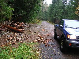 very small wash -over 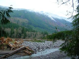 trees litter the entire river bed. 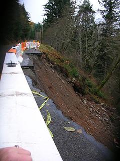 slide before rangers station 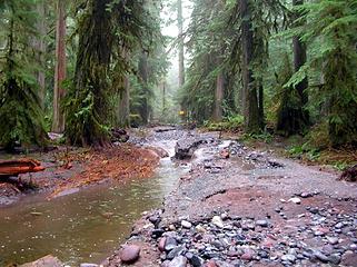 This is the road 1.5-2 miles from rangers station
|
| Back to top |
|
|
dicey
custom title

Joined: 11 May 2004
Posts: 2870 | TRs | Pics
Location: giving cornices a wider berth |
|
dicey
custom title
|
Tue Nov 14, 2006 11:37 am |
|
|
| GeoHiker wrote: | | The only one I will admit to going around on a regular basis is the one on the Index road. |
 What is up with that one anyway?
|
| Back to top |
|
|
Slugman
Its a Slugfest!

Joined: 27 Mar 2003
Posts: 16874 | TRs | Pics
|
|
Slugman
Its a Slugfest!
|
Tue Nov 14, 2006 11:57 am |
|
|
Index road: I chickened out going around that one last spring.  If you can't "do the time" (or "pay the fine") then don't do the crime. If you can't "do the time" (or "pay the fine") then don't do the crime.  The Carbon river road: It looks bad, real bad. But didn't I read recently that the park was/will be expanded by a few hundred acres to accommodate a new route for the road, away from the river? If so, does that mean that the long-term prognosis is good?
|
| Back to top |
|
|
Quark
Niece of Alvy Moore
Joined: 15 May 2003
Posts: 14152 | TRs | Pics
|
|
Quark
Niece of Alvy Moore
|
Tue Nov 14, 2006 7:05 pm |
|
|
Wow, check out photo 9082 and 9070; you can see how high the river came and scoured the soil and moss from the trunk of the trees.
"...Other than that, the post was more or less accurate."
Bernardo, NW Hikers' Bureau Chief of Reporting
"...Other than that, the post was more or less accurate."
Bernardo, NW Hikers' Bureau Chief of Reporting
|
| Back to top |
|
|
kleet
meat tornado

Joined: 06 Feb 2002
Posts: 5303 | TRs | Pics
Location: O no they dih ent |
|
kleet
meat tornado
|
Tue Nov 14, 2006 8:15 pm |
|
|
Those is some handsome photos!
A fuxk, why do I not give one?
A fuxk, why do I not give one?
|
| Back to top |
|
|
andrew e
Member
Joined: 13 Feb 2006
Posts: 147 | TRs | Pics
Location: Seattle |
|
andrew e
Member
|
Tue Nov 14, 2006 10:58 pm |
|
|
Went to look at the Index-Galena road washout today. No one's going to be driving around that one anytime soon. Washout is about 6.5 miles up, but road is closed at about 5.5, walked the rest of it to the washout. As you can see in the pics the river is flowing down at least 200 yards of the road in the distance. Yikes.
|
| Back to top |
|
|
Magellan
Brutally Handsome

Joined: 26 Jul 2006
Posts: 13116 | TRs | Pics
Location: Inexorable descent |
|
Magellan
Brutally Handsome
|
Tue Nov 14, 2006 11:54 pm |
|
|
Tazz and Andrew, thanks for those pix... 
|
| Back to top |
|
|
Canuck
Member
Joined: 05 Jun 2006
Posts: 2137 | TRs | Pics
Location: Lacey WA |
|
Canuck
Member
|
Wed Nov 15, 2006 11:40 am |
|
|
I apologize if this was already posted, I'm short on time and didn't search, but check out if you haven't already the slideshow put together by MRNP folks...
Mt. Rainier damage
|
| Back to top |
|
|
Dogpatch
Member

Joined: 17 Aug 2003
Posts: 1588 | TRs | Pics
Location: the dryside |
|
Dogpatch
Member
|
Wed Nov 15, 2006 11:52 am |
|
|
| andrew e wrote: | | Went to look at the Index-Galena road washout today. |
Any news on the bridge across the Skykomish to Galena?
"Outside of a dog, a book is man's best friend.
Inside of a dog, it's too dark to read." Groucho Marx
"Outside of a dog, a book is man's best friend.
Inside of a dog, it's too dark to read." Groucho Marx
|
| Back to top |
|
|
MCaver
Founder

Joined: 14 Dec 2001
Posts: 5124 | TRs | Pics
|
|
MCaver
Founder
|
Wed Nov 15, 2006 12:10 pm |
|
|
Here's a photo from Mount Rainier Climbing at the Grove as well. The normally 3.5' high interpretive sign is now neck deep in silt.
|
| Back to top |
|
|
MCaver
Founder
Joined: 14 Dec 2001
Posts: 5124 | TRs | Pics
|
|
MCaver
Founder
|
Wed Nov 15, 2006 12:12 pm |
|
|
Andrew E, thanks for the Index-Galena photos. I was up there on Sunday but stopped at the closure. It looked to me like some of the cabins beside the river in that area were completely gone. One lot just had a deck left right on the new riverbank. There was a lot of flood damage and silt in Index as well, and all the sandbags were still up.
|
| Back to top |
|
|
MCaver
Founder
Joined: 14 Dec 2001
Posts: 5124 | TRs | Pics
|
|
MCaver
Founder
|
Wed Nov 15, 2006 12:56 pm |
|
|
|
| Back to top |
|
|
|
|


