| Previous :: Next Topic |
| Author |
Message |
whitebark
Member

Joined: 08 Jul 2005
Posts: 1864 | TRs | Pics
Location: Seattle |
My original plan was to visit Hardy Canyon on Cleman Mtn, but the winter elk closure is still in effect until May 1. So instead I wandered up the Observatory Road to the summit of Manastash Ridge. This turned out to be a pleasant and easy 8 mile walk. The Observatory Road begins on the Wenas Road near Ellensburg Pass. It is gated, but you will probably see a few ATVs as I did, not enough to get annoying.
From the gate, the road winds through pine groves and open meadows with broad vistas, at about the two mile point dipping to cross a branch of Umtanum Creek. After that, the road makes a moderate climb to the ridge crest, where one is greeted with views of the Stuart Range. At a the summit of the ridge is a complex junction; I went right and made the short climb to the observatory. Bright sun, blue skies, flowers out, and meadowlarks singing..who could ask for more?
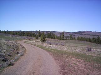 winding road 1 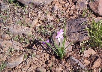 flower.  end of the road. 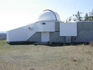 observatory 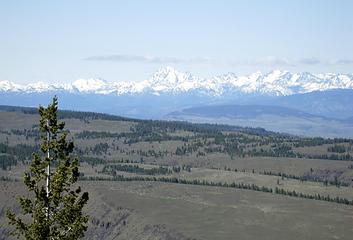 stuart. 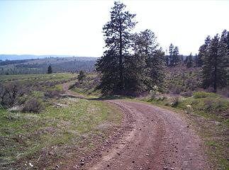 winding road 2.
|
| Back to top |
  
|
|
Quark
Niece of Alvy Moore

Joined: 15 May 2003
Posts: 14152 | TRs | Pics
|
|
Quark
Niece of Alvy Moore
|
 Mon Apr 16, 2007 10:55 am |
|
|
Rich Baldwin and I did Cleman Mtn yesterday. I eyeballed Hardy & Burn Canyon, but Cleman won out.
I like the winding roads on ridges in Central Washington. Nice information on Manastash, thanks.
"...Other than that, the post was more or less accurate."
Bernardo, NW Hikers' Bureau Chief of Reporting
"...Other than that, the post was more or less accurate."
Bernardo, NW Hikers' Bureau Chief of Reporting
|
| Back to top |
|
|
whitebark
Member

Joined: 08 Jul 2005
Posts: 1864 | TRs | Pics
Location: Seattle |
Quark, what route did you use on Cleman? I've been intrigued about the hiking possibilities there.
|
| Back to top |
|
|
Quark
Niece of Alvy Moore
Joined: 15 May 2003
Posts: 14152 | TRs | Pics
|
|
Quark
Niece of Alvy Moore
|
Mon Apr 16, 2007 12:01 pm |
|
|
Bark, we used the Spring/Manning directions to Rd 1701 off Hwy 12 a dozen or so miles beyond Naches; then 1712 and up to the ridge. 1712 is a rough road made of rocks (not gravel). Not recommended for a car, not even a Subaru at this time (maybe after the blowdown is cleared). There are large trees downed across the road, and rough home-made routes arond them. From what we heard from a man we met near the summit was that there was a massive windstorm up there a couple weeks ago (we knew the blowdown was recent; they look new, and you can still smell the fresh break from the stress on the trunks of the trees). Several pretty good sized puddles to drive through, but they didn't seem slick (I had the 4WD engaged).
The Alan Bauer/Dan Nelson book Best Desert Hikes has you going in via Mud Lake just outside of Naches, parking near the lake, and just heading up on foot. I will take this route next, as the other one leaves too much chance for a flat tire. It was a fun road to drive; I'll admit it.
Rd 1701 and 1712 are open (no restrictions) at this time - at any rate, even those closed for habitat will be open May 1st.
But this is YOUR trip report; maybe I'll do one for Cleman today, but I don't have a way to toss any photos up right now.
"...Other than that, the post was more or less accurate."
Bernardo, NW Hikers' Bureau Chief of Reporting
"...Other than that, the post was more or less accurate."
Bernardo, NW Hikers' Bureau Chief of Reporting
|
| Back to top |
|
|
|
|
You cannot post new topics in this forum
You cannot reply to topics in this forum
You cannot edit your posts in this forum
You cannot delete your posts in this forum
You cannot vote in polls in this forum
|
Disclosure: As an Amazon Associate NWHikers.net earns from qualifying purchases when you use our link(s). |


