| Previous :: Next Topic |
| Author |
Message |
Get Out and Go
Member


Joined: 13 Nov 2004
Posts: 2128 | TRs | Pics
Location: Leavenworth |
Thanks to Rob (Wildernessed) for putting this trip together.  He tells me we did 2350' of gain over 9 miles in 9 hours. This was a great trip with Rob, Steve and my son David, rambling over an area of huge panoramas. We met in South Wenatchee and made the short trip down through Malaga, turning off the Colockum Road onto Tarpiscan Road and parked at a fork a couple miles before it is gated to all motorized vehicles (Hikers Welcome He tells me we did 2350' of gain over 9 miles in 9 hours. This was a great trip with Rob, Steve and my son David, rambling over an area of huge panoramas. We met in South Wenatchee and made the short trip down through Malaga, turning off the Colockum Road onto Tarpiscan Road and parked at a fork a couple miles before it is gated to all motorized vehicles (Hikers Welcome  ). By parking here, we were able to walk an old road down to the river and head south toward Cape Horn. Our intent was to uncover an old sheep/cattle trail beyond the ruins of Spanish Castle across the face of Cape Horn to reach West Bar. Not finding suitable passage we ascended around the northeast shoulder of Cape Horn, alternating between talus, flowers, sage and grass. Higher up we encountered a small area where the cactus took a liking and were just beginning to bloom. We reached the flat summit of Cape Horn for stupendous lunchtime views. We began our descent, and were surprised to look down into the water and discern the footprint of the old Spanish Castle which was victim to the waters of the Wanapum Dam. We now started working over and down phlox-covered hills to the merging of the Tarpiscan Creek Forks. Not finding a crossing, we shed boots to ford calf deep water in both forks to follow a talus-free route up the other side of the canyon. We climbed to intersect the gated portion of Tarpiscan Road and strolled back down a couple miles to complete our loop. A wonderful snake-free adventure, which I would not recommend in August. ). By parking here, we were able to walk an old road down to the river and head south toward Cape Horn. Our intent was to uncover an old sheep/cattle trail beyond the ruins of Spanish Castle across the face of Cape Horn to reach West Bar. Not finding suitable passage we ascended around the northeast shoulder of Cape Horn, alternating between talus, flowers, sage and grass. Higher up we encountered a small area where the cactus took a liking and were just beginning to bloom. We reached the flat summit of Cape Horn for stupendous lunchtime views. We began our descent, and were surprised to look down into the water and discern the footprint of the old Spanish Castle which was victim to the waters of the Wanapum Dam. We now started working over and down phlox-covered hills to the merging of the Tarpiscan Creek Forks. Not finding a crossing, we shed boots to ford calf deep water in both forks to follow a talus-free route up the other side of the canyon. We climbed to intersect the gated portion of Tarpiscan Road and strolled back down a couple miles to complete our loop. A wonderful snake-free adventure, which I would not recommend in August. 
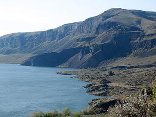 Working Toward Cape Horn 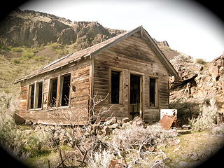 Tarpiscan School 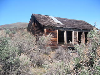 Tarpiscan School  Farm Stuff 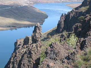 Columbia 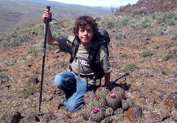 David, Son of Get Out and Go 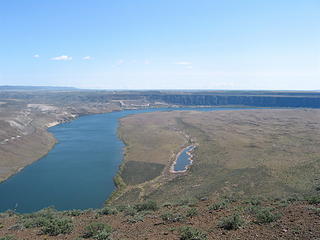 West Bar 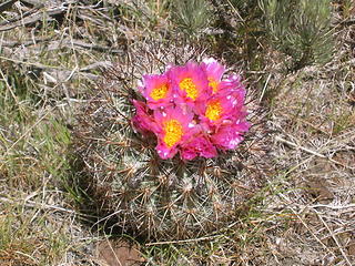 Thorny Thing 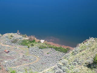 Submerged Foundation of Spanish Castle 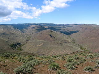 South and North Forks of Tarpiscan Creek Old Fence 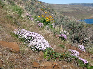 Phloxy Hillside
"These are the places you will find me hiding'...These are the places I will always go."
(Down in the Valley by The Head and The Heart)
"Sometimes you're happy. Sometimes you cry.
Half of me is ocean. Half of me is sky."
(Thanks, Tom Petty)
"These are the places you will find me hiding'...These are the places I will always go."
(Down in the Valley by The Head and The Heart)
"Sometimes you're happy. Sometimes you cry.
Half of me is ocean. Half of me is sky."
(Thanks, Tom Petty)
|
| Back to top |
  
|
|
lookout bob
WTA proponent.....

Joined: 12 Apr 2005
Posts: 3043 | TRs | Pics
Location: wta work while in between lookouts |
|
lookout bob
WTA proponent.....
|
 Mon Apr 16, 2007 5:32 pm |
|
|
GOAG...wow...great TR....I love that area.....I only hiked in the Tarpiscan area once and didn't get far. Love the old buildings...great photos. I still fantasize about a one way spring time hike from Whiskey Dick to the Tarpiscan....thanks for posting!
"Altitude is its own reward"
John Jerome ( from "On Mountains")
"Altitude is its own reward"
John Jerome ( from "On Mountains")
|
| Back to top |
|
|
wildernessed
viewbagger

Joined: 31 Oct 2004
Posts: 9275 | TRs | Pics
Location: Wenatchee |
It was an awesome trip  , part abandoned road, off trail meandering, and a return to the foot traffic only section of Tarpiscan Rd , part abandoned road, off trail meandering, and a return to the foot traffic only section of Tarpiscan Rd  . .
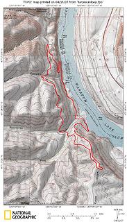 Tarpiscan Cape Horn Loop 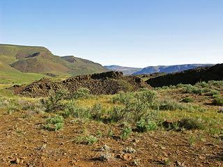 Open Desert terrain near the trailhead 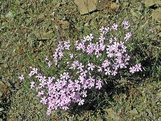 Phlox 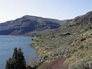 Working our way toward Cape Horn along an abandoned road that drops down from Tarpiscan Road and meanders South 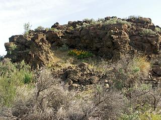 Nice arrangement of Balsam Root and Basalt 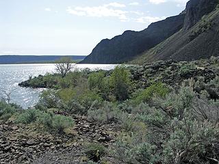 From the abandoned road turned trail N. of Cape Horn and the cliff line that seperates you from West Bar  N. Fork Tarpiscan Creek Canyon  Steve looking W admiring the vast open expanse of the Colockum Wildlife Refuge  Columbia River and West Bar  Cape Horn Plateau edge with nearly 1500' cliffs, West Bar, and Columbia River basin 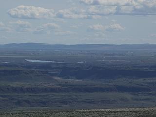 Looking E at Ancient Lakes area from Cape Horn Plateau around 2247' 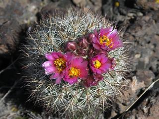 One of many blooming hedge hog cactus along the upper ridge leading to Cape Horn 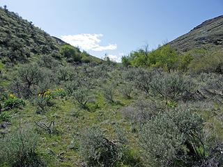 Looking up the Tarpiscan Creek Canyon 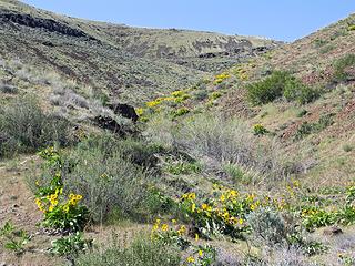 Nice looking ridge to take up to Tarpiscan Rd. 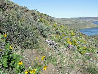 Climbing up through the desert wildflowers after fording the N and S forks of Tarpiscan Creek 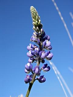 Lupine 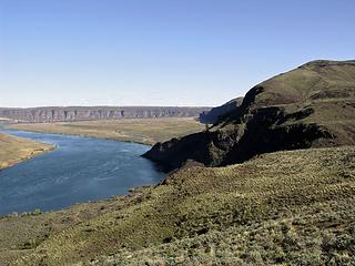 Looking back at the E terminus of Cape Horn as it drops down into the Columbia River, with West Bar in the background 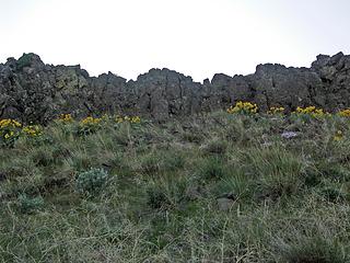 Balsam Root and Basalt above Tarpiscan Rd. 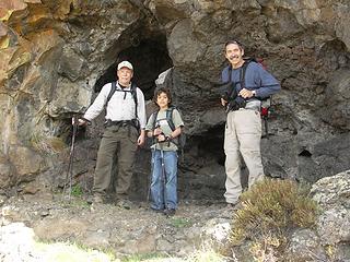 Tony, David, and Steve checking out some small caves in a rock formation
Living in the Anthropocene
Living in the Anthropocene
|
| Back to top |
|
|
Get Out and Go
Member
Joined: 13 Nov 2004
Posts: 2128 | TRs | Pics
Location: Leavenworth |
Rob insisted that I post this TR only if I could supply it with a jazzy title.  BTW, here's a link to a photo trip report, a trusty Subaru made to West Bar a few years ago....quite impressive. http://www.pbase.com/listorama/2003wa_bar
And here's some background on Spanish Castle from The Wenatchee World:
"Area Gets Its Name From Castle Built in 1918" By Dan Wheat, World staff writer, Posted February 07, 2007
TRINIDAD -- The development being proposed for the Columbia River, four miles west of Trinidad, is across the river and slightly north from where a cattle baron built a large home, known as the Spanish Castle, 89 years ago.
Construction of Spanish Castle was completed in 1918 at a cost of more than $20,000 by Lester Coffin, according to reports in The Wenatchee Daily World.
Coffin and his brother were Yakima-based cattlemen and "lords of the Tarpiscan range who counted their horses, cattle and sheep by the thousands," according to a May 21, 1927 World article.
Coffin dreamed for years of having a home along the Columbia River, resembling the residence of a Mexican president of the early 1900s.
The location he chose, on the river at the mouth of Tarpiscan Creek, was two miles into Kittitas County from the Kittitas-Chelan County line. It was remote and almost inaccessible.
An earlier rock house at the site had burned. Construction materials for the new house were hauled in over the rough Colockum Pass Road in covered wagons. Some materials were brought in from across the river.
The house had 13 to 17 rooms, including a spacious entrance hall, a reception room, living room, five bedrooms, two bathrooms and an indoor pool. Coffin didn't get to enjoy it. Just a few days after it was done, he died in a Wenatchee hospital. BTW, here's a link to a photo trip report, a trusty Subaru made to West Bar a few years ago....quite impressive. http://www.pbase.com/listorama/2003wa_bar
And here's some background on Spanish Castle from The Wenatchee World:
"Area Gets Its Name From Castle Built in 1918" By Dan Wheat, World staff writer, Posted February 07, 2007
TRINIDAD -- The development being proposed for the Columbia River, four miles west of Trinidad, is across the river and slightly north from where a cattle baron built a large home, known as the Spanish Castle, 89 years ago.
Construction of Spanish Castle was completed in 1918 at a cost of more than $20,000 by Lester Coffin, according to reports in The Wenatchee Daily World.
Coffin and his brother were Yakima-based cattlemen and "lords of the Tarpiscan range who counted their horses, cattle and sheep by the thousands," according to a May 21, 1927 World article.
Coffin dreamed for years of having a home along the Columbia River, resembling the residence of a Mexican president of the early 1900s.
The location he chose, on the river at the mouth of Tarpiscan Creek, was two miles into Kittitas County from the Kittitas-Chelan County line. It was remote and almost inaccessible.
An earlier rock house at the site had burned. Construction materials for the new house were hauled in over the rough Colockum Pass Road in covered wagons. Some materials were brought in from across the river.
The house had 13 to 17 rooms, including a spacious entrance hall, a reception room, living room, five bedrooms, two bathrooms and an indoor pool. Coffin didn't get to enjoy it. Just a few days after it was done, he died in a Wenatchee hospital.
"These are the places you will find me hiding'...These are the places I will always go."
(Down in the Valley by The Head and The Heart)
"Sometimes you're happy. Sometimes you cry.
Half of me is ocean. Half of me is sky."
(Thanks, Tom Petty)
"These are the places you will find me hiding'...These are the places I will always go."
(Down in the Valley by The Head and The Heart)
"Sometimes you're happy. Sometimes you cry.
Half of me is ocean. Half of me is sky."
(Thanks, Tom Petty)
|
| Back to top |
|
|
anon23bf
Member

Joined: 29 Apr 2003
Posts: 66 | TRs | Pics
Location: WA, USA |
|
anon23bf
Member
|
Mon Apr 16, 2007 8:28 pm |
|
|
Fascinating report and information -- thanks. I've done a similar route up to Cape Horn several times over the years, and was curious about the area's history, given the assorted remnants of civilization scattered throughout.
I've also looked for a shortcut to West Bar from near the Tarpiscan Creek area. Several times I tried following game trails south along the face of Cape Horn, but this got too dangerous for me. Nonetheless, I've observed elk and bighorn sheep heading there, so it may still be doable, at least by those with rock-climbing experience.
Without the shortcut, I've reached West Bar by an old track (closed to vehicles) heading south across the Cape Horn plateau for about 1 mile, then 3 more miles east to descend steeply among the cliffs.
Is the route in your Topo map a recorded GPS track? I was also wondering whether other sources publicize this route; it doesn't appear in either the new or old Desert Hikes book.
Finally, does anyone know about the planned "development" mentioned in the Wenatchee World article? The proposed location 4 miles west of Trinidad seems to put it right near the underwater remnants of the Spanish Castle. I hope it's not something like the Crescent Bar area (over on the other side a few miles southeast).
|
| Back to top |
|
|
wildernessed
viewbagger
Joined: 31 Oct 2004
Posts: 9275 | TRs | Pics
Location: Wenatchee |
I went to the Colockum Wildlife Center just off the road and talked to the guy in charge. I looked at the options from that area and he gave me a map which is huge, about the size of a USGS Quad, but a larger scale. The area is so big the map is on the front and back and divided into E and W sides. It has the topographic features, with current and abandoned roads. The map is nice, they willl start printing only nontopographic maps in the future, so get them why they have them. I noticed the old abandoned road that led to the bottom or river level of Cape Horn. Looking at it West Bar is only a short distance if you could cross the cliffs. He said there was an old trail crossing the cliffs at one time and he thought it was still there. From the bottom it looks like scree that angles down into the water that you'd have to traverse around to a blind spot and you can only see thr vertical cliff. There were no obvious signs of any trail or path low and we didn't explore out to see if you might traverse out then ascend up to a bench and through to the other side (we should have), but when we went off trail along the ridge near the edge I came across a well worn trail maybe 500' above the water that went along the face, I followed it a little ways until I saw that it was probably less than a foot wide on the sloping screeish rock face with a vertical drop of around 500' to rocks below and felt it was not the prudent route. That may have been what you saw going that way. It's possible that a route exist at river level by crossing the scree / talus and ascending upward and over. The map I made is from TOPO and follows the abandoned road all the way to the N side of Cape Horn near the river. The route up was off trail meandering towards the highpoint and plateau and then back down crossing both forks of the creek and up the easiest ridge to gain Tarpiscan Rd. and out. It's so open you can see your landmarks and navigate easily. The route just looked like the neat thing to do to make a day of it, we added the plateau once we were at the bottom:hockeygrin:
Living in the Anthropocene
Living in the Anthropocene
|
| Back to top |
|
|
anon23bf
Member
Joined: 29 Apr 2003
Posts: 66 | TRs | Pics
Location: WA, USA |
|
anon23bf
Member
|
Mon Apr 16, 2007 9:56 pm |
|
|
Thanks -- I guess we had similar experiences trying to find a shortcut.
I did some research on the planned nearby development, and it's quite depressing. Apparently, hundreds of condos and residences are slated to be built in the currently bare area on the east shore, along with what looks like a resort on the west side, right about where you hiked.
For more info, see the developer's Web page, http://www.iinet.com/~entezar/, and click on 'Projects', then 'Resort'. Clicking on the lower right of the image seems to show the 'Columbia River Estates' planned for the eastern shore, whereas clicking on the upper left shows 'Spanish Castle Resort'... and I could be wrong, but that looks a lot like Cape Horn on the upper left. 
|
| Back to top |
|
|
wildernessed
viewbagger
Joined: 31 Oct 2004
Posts: 9275 | TRs | Pics
Location: Wenatchee |
Living in the Anthropocene
|
| Back to top |
|
|
the Zachster
Member

Joined: 17 Jan 2007
Posts: 4776 | TRs | Pics
Location: dog training |
Nice report and pics! I always like hearing about new places. But I have to admit, when I saw the subject line, I thought you were making it up! The names sound like some exotic places in a new Tolkien novel  Thanks again! Thanks again!
"May I always be the kind of person my dog thinks I am"
"May I always be the kind of person my dog thinks I am"
|
| Back to top |
|
|
marta
wildflower maven

Joined: 07 May 2003
Posts: 1761 | TRs | Pics
|
|
marta
wildflower maven
|
Wed Apr 18, 2007 8:47 pm |
|
|
Great report and pictures. I've driven up a bit into this area but this is all new to me. I'm surprised to see the cactus already in bloom. Seems early. I'm also pretty depressed to hear about the development plans. I'm hoping they stay on the east side of the river where there is already a bit of development and leave the west wild.
|
| Back to top |
|
|
wildernessed
viewbagger
Joined: 31 Oct 2004
Posts: 9275 | TRs | Pics
Location: Wenatchee |
Everyone was surprised at the cactus along the upper section of the ridge leading to Cape Horn. West Bar is sweet and you look over at Crescent Bar and it's quite the eye sore with Condos staggered up the cliff side and all the developement below near the river. Although I was tempted to swim the river and grab a snickers bar at the minimart. 
Living in the Anthropocene
Living in the Anthropocene
|
| Back to top |
|
|
jasonracey
Member

Joined: 14 Jul 2006
Posts: 171 | TRs | Pics
Location: Issaquah |
Cool TR thanks. The diversity in this state is amazing. Just looking at your shots was like medicine for my soul. I'm feeling very mossy after a long wet winter and this was great.
|
| Back to top |
|
|
lookout bob
WTA proponent.....
Joined: 12 Apr 2005
Posts: 3043 | TRs | Pics
Location: wta work while in between lookouts |
|
lookout bob
WTA proponent.....
|
Thu Apr 19, 2007 1:17 pm |
|
|
Wildernessed, GOAG...did you guys get a permit to go in there? Just curious..... 
"Altitude is its own reward"
John Jerome ( from "On Mountains")
"Altitude is its own reward"
John Jerome ( from "On Mountains")
|
| Back to top |
|
|
wildernessed
viewbagger
Joined: 31 Oct 2004
Posts: 9275 | TRs | Pics
Location: Wenatchee |
Heres the Washington Dept. of Fish and Wildlife site / contact for Colockum
I was told you could park and meander wherever, the guy never mentioned a WDFW permit, but I see the Colockum Wiildlife Refuge does, while the WDFW website concerning the area is not mentioned as needing one. The road is gated to prevent easy access through private property to vehicles, while the private landowners allow hikers to pass through.
Living in the Anthropocene
Living in the Anthropocene
|
| Back to top |
|
|
SpanishCastle12
Member
Joined: 23 Feb 2010
Posts: 2 | TRs | Pics
Location: Wenatchee |
I'm glad to hear you find this property beautiful, because I feel the same. I grew up camping, hiking, and horseback riding here and the area is dear to my heart. :-) If you plan on hiking through again, I can always suggest certain places to check out (and give you some background information and cool facts about the place!)
|
| Back to top |
|
|
|
|
You cannot post new topics in this forum
You cannot reply to topics in this forum
You cannot edit your posts in this forum
You cannot delete your posts in this forum
You cannot vote in polls in this forum
|
Disclosure: As an Amazon Associate NWHikers.net earns from qualifying purchases when you use our link(s). |


