| Previous :: Next Topic |
| Author |
Message |
Elvis
Shuffl'n

Joined: 09 Jun 2004
Posts: 1804 | TRs | Pics
Location: del Boca Vista |
|
Elvis
Shuffl'n
|
 Sun Jul 08, 2007 8:38 pm |
|
|
Managed to get some free time this weekend for a short, close-to-home hike today. Kids were invited... but opted to stay home to play with the puppy. Oh well... at least I invited them.
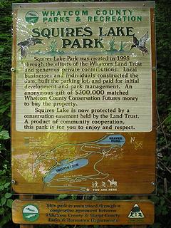
Squires Lake is located along the I-5 corridor at the Whatcom/Skagit county line and is a Whatcom County Park that has a couple loops around a small lake and also a pond created from a beaver dam.
 Trailhead map 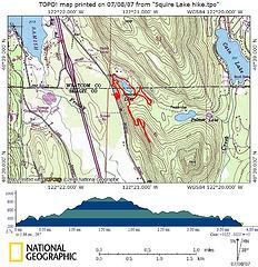 Squire Lake Map2 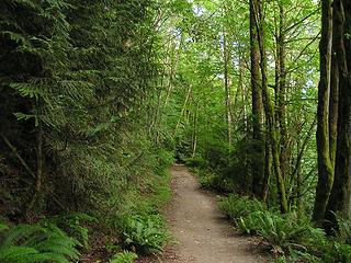 Lower Trail 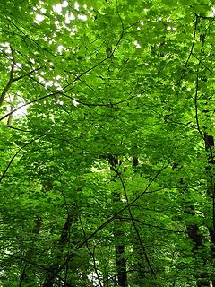 Tunnel of greens 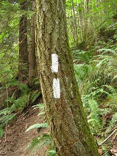 Switchback marker 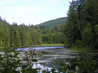 Squire Lake 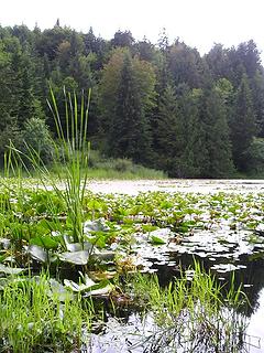 Squire Lake  I can only conclude that this is part of some longer 'Pacific Northwest Trail' project that isn't well signed.
This ridge trail continued along a ridge, gaining elevation and also becoming more overgrown. Suddenly you break out into a gravel clearing that is obviously the end of an old logging road. At this point there is a sign marking this trailhead (end?) as "1130". Across this clearing is an identical sign reading "1140". At the 1140 sign it appears there once was an ongoing trail but it is almost completely overgrown at this point so I didn't try to follow it past the blackberry bushes.
Turning about 130 degrees allows you to follow this logging road upwards. After a short while it comes to a 'Y' with a road labeled "1110". Another sign indicates the road I'm following is "1100". I don't see these on my Topo maps.
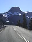
I followed 1100 for a ways further south until it reached my highest elevation (almost 900 feet) before it began an ongoing descent. At this point I turned around and chose the 1110 spur. This spur deadends after a short distance, but provides some peek-a-boo glimpses of Lake Samish to the northwest but more notable are the eastern views of Lake Palmer and distant peaks which must be the Sisters range. I can only conclude that this is part of some longer 'Pacific Northwest Trail' project that isn't well signed.
This ridge trail continued along a ridge, gaining elevation and also becoming more overgrown. Suddenly you break out into a gravel clearing that is obviously the end of an old logging road. At this point there is a sign marking this trailhead (end?) as "1130". Across this clearing is an identical sign reading "1140". At the 1140 sign it appears there once was an ongoing trail but it is almost completely overgrown at this point so I didn't try to follow it past the blackberry bushes.
Turning about 130 degrees allows you to follow this logging road upwards. After a short while it comes to a 'Y' with a road labeled "1110". Another sign indicates the road I'm following is "1100". I don't see these on my Topo maps.
I followed 1100 for a ways further south until it reached my highest elevation (almost 900 feet) before it began an ongoing descent. At this point I turned around and chose the 1110 spur. This spur deadends after a short distance, but provides some peek-a-boo glimpses of Lake Samish to the northwest but more notable are the eastern views of Lake Palmer and distant peaks which must be the Sisters range.
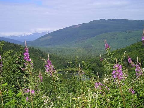 1 label Fireweed (of course) over Lake Palmer 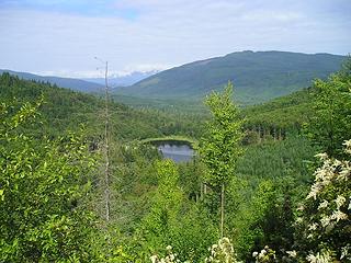 Palmer Lake 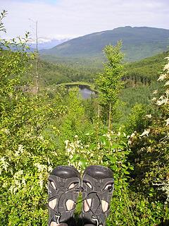 silly_traveller ;=) 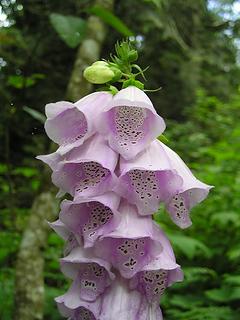 Foxglove 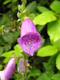 Foxglove 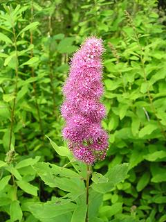 not foxglove 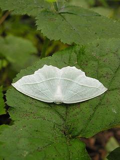 Needs better strategy...  Nature's details 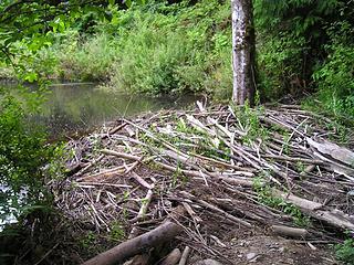 Beaver dam
"Ill habits gather unseen degrees, as brooks make rivers, rivers run to seas." ~John Dryden
My Trip List
"Ill habits gather unseen degrees, as brooks make rivers, rivers run to seas." ~John Dryden
My Trip List
|
| Back to top |
  
|
|
jackchinook
Member

Joined: 28 Jan 2004
Posts: 684 | TRs | Pics
Location: Winthrop |
Cool TR. I used to kick around Cain Lake when I was learnin' in B'ham...mostly drinking heavily and puking off the dock though...not out exploring cool beaver ponds and vistas of the Alger Alps.
Looks like a neat place.
BTW, your purple loosestrife looks more like fireweed to me.
|
| Back to top |
|
|
yew
non-technical
Joined: 12 Dec 2005
Posts: 1173 | TRs | Pics
Location: Bellingham |
|
yew
non-technical
|
Tue Jul 10, 2007 2:05 am squires lake hiking
|
|
|
Elvis:
Thanks for posting this TR. I've been thinking about going to Squires Lake for a long time after seeing it on the Wash. DNR map but wondered what it looked like and what the trails are like.
"I aint jokin woman, I got to ramble...We gonna go walkin through the park every day." - Led Zeppelin
"I aint jokin woman, I got to ramble...We gonna go walkin through the park every day." - Led Zeppelin
|
| Back to top |
|
|
Elvis
Shuffl'n

Joined: 09 Jun 2004
Posts: 1804 | TRs | Pics
Location: del Boca Vista |
|
Elvis
Shuffl'n
|
Tue Jul 10, 2007 7:09 am |
|
|
JackC - maybe it is fireweed... I'm not familiar with the similarities or differences between them. I used to live in the Alger area and our neighborhood hot topic was the invasion of the noxious purple loostrife so it seemed a plausible deduction.
Yew_betula: Yew bet! Glad it could be of service.
My whole excursion took less that two hours - but I really want to follow that road 1100. A bicycle would be really helpful.
FWIW, over the last 10 years I explored a few logging roads in this area:
One started in Alger and headed northward to the first NE peak which had some firepits at the summit - likely a local teen-redneck hangout.
Another logging road started further north of Squires Lake and north of the S. Lk Samish I-5 onramp which headed E/NE. The views of the San Jans available looking across Samish Lake and the Chuckanut range was spectacular! At the time there were lots of clearcuts but I think those have greened-up a lot in the last five years so your foreground will be a bit more lush than what I saw.
Finally, I followed a road south from the N. Lake Samish exit area, just south of the rifle range. It went down to the bridge over the creek that you can see from I-5, but it had a beefy fence on it which clearly was intended to keep all passerby out of the area. It would be possible (without a bicycle) to go down the valley, cross the creek and ascend the other side, but I opted out.
All my excursions on these logging roads were empty of people. Complete solitude (except for the I-5 noise).
Happy trails.
"Ill habits gather unseen degrees, as brooks make rivers, rivers run to seas." ~John Dryden
My Trip List
"Ill habits gather unseen degrees, as brooks make rivers, rivers run to seas." ~John Dryden
My Trip List
|
| Back to top |
|
|
yew
non-technical
Joined: 12 Dec 2005
Posts: 1173 | TRs | Pics
Location: Bellingham |
|
yew
non-technical
|
Tue Jul 10, 2007 11:34 am hikes in Whatcom County
|
|
|
| Quote: | | FWIW, over the last 10 years I explored a few logging roads in this area...All my excursions on these logging roads were empty of people. Complete solitude |
I'm totally down with these kinds of hikes...atleast on weekdays in the spring!
The gated gravel road up the hill from the Hertz Trailhead on Lake Whatcom is a nice hike too. There's a real trail on the bottom which ties into the gravel road which steeply ascends up through a powerline corridor. It tops out up on a high saddle with views of Bellingham, Ferndale lowlands, the water, east side of Lookout/Galbraith Mtn and much more. The road and powerline corridor keep on going to Acme. It's mostly DNR land.
There's also logging road hiking on DNR land on the "Y Road" trailhead. One route goes up a logging road with new clearcuts which ends berm where a horse trail begins in mature forest. The trail goes to another clearcut and bermed-off logging road on the noth end of Stewart Mtn which has great views of the lowlands in between Nuget's Corner and Bellingham and Squalicum Mtn.
There are a few other hikes. Anybody can send me a PM for more directions.
on plants:
I think the "not fireweed" is Spiraea (Spiraea douglasii). "Purple loostrife over Lake Palmer" is definitely fireweed.
"I aint jokin woman, I got to ramble...We gonna go walkin through the park every day." - Led Zeppelin
"I aint jokin woman, I got to ramble...We gonna go walkin through the park every day." - Led Zeppelin
|
| Back to top |
|
|
|
|
You cannot post new topics in this forum
You cannot reply to topics in this forum
You cannot edit your posts in this forum
You cannot delete your posts in this forum
You cannot vote in polls in this forum
|
Disclosure: As an Amazon Associate NWHikers.net earns from qualifying purchases when you use our link(s). |


