| Previous :: Next Topic |
| Author |
Message |
whitebark
Member


Joined: 08 Jul 2005
Posts: 1864 | TRs | Pics
Location: Seattle |
With the new gatein, it's now a hike, not a drive. I decide to give this new hike a try in the form of a loop, walking up the road and down the trail.
First you have to get to the trailhead of course. The Mid Fork Road is in fair shape with numerous small potholes. By historic standards it is not bad. Even in my Honda Fit, I could average about 30 mph to Taylor River. The section from Taylor River is worse, but far better than it used to be. The Fit could handle it at about 15 to 20 mph. If you have a rough, tough SUV, much higher speeds are possible, but blind curves make higher speed unsafe. I was pleasantly surprised at how little time to took to get to Dingford, about a hour and a half from Seattle.
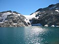
At the Dingford Gate I hoisted pack and started walking. The road walk turned out to be more pleasant than expected. Right away you pass a magnificent waterfall on Dingford Creek, one that you might not notice if you are driving. At the half mile point, you pass a great mossy cliff. The road approaches the river at many spots, and I enjoyed viewing its beautiful rushing waters and the snow-patched peaks rising far above. Old trashy car camps have now become quiet walk-in sites...there are a number of them along the road.
I was surprised at the number of cars beyond the gate; are they giving out keys like candy? I was passed twice by a guy in a red sedan. On the way back, he offered me a ride to Goldmyer, which I politely declined. The car driver might have been the spring's caretaker. Something to remember: if you look wholesome and smile nicely, you may be able to "hitchhike" at least as far as Goldmyer.
One hour and 40 minutes later, I arrive at Goldmyer. Not having reservations to soak in the springs, I soon set out on the Mid Fork Trail to begin the long return back to the TH. At once I encountered the biggest obstacle of the trip, Burntboot Creek, which is a mighty rush of water almost as big as the Mid Fork itself. There is a jumble of logs that form a bridge of sorts. This bridge is not great and some acrobatic skills are required to cross it. IF the logs were wet, it could get rather "exciting".
Beyond the "bridge", the Mid Fork trail was in O.K. shape, a little rocky and brushy. I looked in vain for the old Cascade Crest Trail to Red Pass (gotta try that sometime, I hear people are using it). After a mile or so, the trail gets up on an old RR grade and becomes fast and easy to walk on. Old logging artifacts are seen occasionally; at one campsite there is an rusty drum and piece of rail. At Rock Creek the trail briefly drops off the RR grade to ford the creek. The trail leaves the RR grade for good in the last mile approaching Dingford Creek. Earthcorps has been working this section recently and the trail is in good shape here. After admiring the impressive cataract in the MidFork river at the Dingford Bridge, I slogged up the final little hill back to the car.
The overall loop hike is about 9 miles. A nice day of hiking, all in all.
|
| Back to top |
  
|
|
Gil
Member

Joined: 29 Sep 2004
Posts: 4062 | TRs | Pics
|
|
Gil
Member
|
 Wed Jul 25, 2007 11:29 am |
|
|
Thanks for the report -- full of good info.
And beware the jubjub bird.
Friends help the miles go easier.
Klahini
Friends help the miles go easier.
Klahini
|
| Back to top |
|
|
Magellan
Brutally Handsome

Joined: 26 Jul 2006
Posts: 13116 | TRs | Pics
Location: Inexorable descent |
|
Magellan
Brutally Handsome
|
Wed Jul 25, 2007 12:30 pm |
|
|
I want some of that candy. I will use it to make friends! 
|
| Back to top |
|
|
Dean
(aka CascadeHiker)

Joined: 02 Mar 2002
Posts: 1967 | TRs | Pics
Location: ex Kennewick, Wa & Lehi Utah |
|
Dean
(aka CascadeHiker)
|
Wed Jul 25, 2007 1:01 pm |
|
|
Wow, you are getting around. Just barely back from a neat trip and already hitting the trails here again. Impressive for sure  Thanks for you reports from the road and for this one. Thanks for you reports from the road and for this one.
|
| Back to top |
|
|
RonL
Member

Joined: 22 Nov 2006
Posts: 131 | TRs | Pics
|
|
RonL
Member
|
Wed Jul 25, 2007 1:07 pm |
|
|
to find the trail to Red Pass, cross the creek about even with the GoldMeyer Dwelling, then start nosing around uphill and upstream, if you get to the next drainage, Goat Creek I think it is, you probably went too far. It's a steep trail but it was in pretty good shape a year or so ago.
|
| Back to top |
|
|
Backpacker Joe
Blind Hiker

Joined: 16 Dec 2001
Posts: 23956 | TRs | Pics
Location: Cle Elum |
That topo program is funny. If you zoom on Goldmeyer at the 7.5 (5 of 5) level you cant see a trail up Red Pass. If you back off one (4 of 5) 100K level you can see the trail up Lundin Peak over to Red Pass. The trail is JUST before Goat Creek.
"If destruction be our lot we must ourselves be its author and finisher. As a nation of freemen we must live through all time or die by suicide."
Abraham Lincoln
"If destruction be our lot we must ourselves be its author and finisher. As a nation of freemen we must live through all time or die by suicide."
Abraham Lincoln
|
| Back to top |
|
|
whitebark
Member
Joined: 08 Jul 2005
Posts: 1864 | TRs | Pics
Location: Seattle |
| Backpacker Joe wrote: | | That topo program is funny. If you zoom on Goldmeyer at the 7.5 (5 of 5) level you cant see a trail up Red Pass. If you back off one (4 of 5) 100K level you can see the trail up Lundin Peak over to Red Pass. The trail is JUST before Goat Creek. |
The Garmin maps preloaded on micro-sd cards are quite out-of-date, and show a treasure trove of abandoned trails, too. My GPS with the card installed shows the Red Pass trail as well as some other surprises, like the Mt Olson trail in the Olympics, and the location of the old Nordrum Lookout in the mid-fork area.
|
| Back to top |
|
|
kiliki
Member
Joined: 07 Apr 2003
Posts: 2325 | TRs | Pics
Location: Seattle |
|
kiliki
Member
|
Thu Jul 26, 2007 4:55 pm |
|
|
For some reason I thought Goldmeyer guests would get keys to drive there (not sure how I thought that would work)-so everyone has to hike there, unless they bike or hitch with the caretaker?
|
| Back to top |
|
|
Tom
Admin
Joined: 15 Dec 2001
Posts: 17853 | TRs | Pics
|
|
Tom
Admin
|
Thu Jul 26, 2007 5:24 pm |
|
|
Nope, guests don't get keys. But I think it's great to see so many cars past the gate. Would love to see the inholders find a loophole to stick it to those who tried to cut off public access, and provide access for a nominal fee to cover mantenance.
|
| Back to top |
|
|
whitebark
Member

Joined: 08 Jul 2005
Posts: 1864 | TRs | Pics
Location: Seattle |
My initial post may have made the road sound like a traffic jam. To be specific, I saw 5 cars past the gate. One SUV drove by while I was walking, two were parked along the river, and two were at the springs (including the red sedan that seemed to be shuttling people). One car sighting was a bit mysterious-- an old station wagon near the river looked like it had been parked awhile; although not obviously junked, it was covered with leaves.
I saw a number of walkers enjoying the new "trail", also.
|
| Back to top |
|
|
thebrowze
Member
Joined: 10 Jul 2007
Posts: 8 | TRs | Pics
|
Was thinking about overnighting at Goldmyer in January. Anyone been up there during winter? Wondering about how the hike in would be and whether it would require snowshoes.
|
| Back to top |
|
|
Dayhike Mike
Bad MFKer
Joined: 02 Mar 2003
Posts: 10958 | TRs | Pics
Location: Going to Tukwila |
Definitely bring snowshoes.
"There is only one basic human right, the right to do as you damn well please. And with it comes the only basic human duty, the duty to take the consequences." -P.J. O'Rourke
"Ignorance is natural. Stupidity takes commitment." -Solomon Short
"There is only one basic human right, the right to do as you damn well please. And with it comes the only basic human duty, the duty to take the consequences." -P.J. O'Rourke
"Ignorance is natural. Stupidity takes commitment." -Solomon Short
|
| Back to top |
|
|
David
Member
Joined: 09 Jul 2006
Posts: 168 | TRs | Pics
|
|
David
Member
|
Fri Jul 27, 2007 12:44 am |
|
|
I think goldmyer is nicest in the winter w/ cooler temps. I've never been there when there was snow, but lots of pluses: nicer soak, lower river (doesn't matter now with the bridge), less people, etc.
It's a great time of year up there.
david
|
| Back to top |
|
|
Gil
Member
Joined: 29 Sep 2004
Posts: 4062 | TRs | Pics
|
|
Gil
Member
|
Sat Jul 28, 2007 12:51 am |
|
|
We rode bikes up the MFK today. Stopped at Goldmyer for a soak on the way up. Nice, just two other people in the hot springs. Then we rode the rest of the way up to the "old" Dutch Miller Gap trailhead. Sat out by that big pool and watched the fish rise.
The five miles up to Goldmyer went by in a half hour. But the 2 1/2 up to the trailhead was HARD! I hate to admit it, but I actually got off my bike and walked twice!
But a really nice day up there. We didn't see anybody on the way in or out until we got almost back to the Dingford gate.
Friends help the miles go easier.
Klahini
Friends help the miles go easier.
Klahini
|
| Back to top |
|
|
Sewellel
Member
Joined: 02 Mar 2005
Posts: 58 | TRs | Pics
|
|
Sewellel
Member
|
Sun Jul 29, 2007 6:23 pm |
|
|
| whitebark wrote: | | One car sighting was a bit mysterious-- an old station wagon near the river looked like it had been parked awhile; although not obviously junked, it was covered with leaves. |
That car belongs to Bob Jackson's guard/worker. Every year you will see a different car parked there for extended periods of time.
|
| Back to top |
|
|
|
|


