| Previous :: Next Topic |
| Author |
Message |
Sadie's Driver
Sadie's Driver


Joined: 24 Apr 2006
Posts: 1763 | TRs | Pics
Location: Welcome Pass |
Who would have thunk?  Wanting to avoid the craziness anywhere near a mountain pass, Jim K and I figured that heading north to Oyster Dome - just a couple of miles as the crow or seagull flies from Puget Sound - would mean little, if any snow. As soon as we took Exit 240 off of I-5 and headed west towards the trailhead (turn left on Barrel-something road - less than a mile from the freeway; then you turn right in .6 miles on the Blanchard Hill Road) there was slippery snow on the road. We opted to go only about a mile or so up the road to the lower parking lot, since there was probably about a 1/2 foot of snow on the road and, basically, we are wussies. The weather was predicted to be scattered showers basically through the day. Well, there were some clouds around - but it continued to clear and was a beautiful day. It was about 34 degrees when we started at the lower trailhead about 9:45 a.m. There were two other guys who showed up - they had parked further down the road, not wanting to get stuck in the snow higher up. Wanting to avoid the craziness anywhere near a mountain pass, Jim K and I figured that heading north to Oyster Dome - just a couple of miles as the crow or seagull flies from Puget Sound - would mean little, if any snow. As soon as we took Exit 240 off of I-5 and headed west towards the trailhead (turn left on Barrel-something road - less than a mile from the freeway; then you turn right in .6 miles on the Blanchard Hill Road) there was slippery snow on the road. We opted to go only about a mile or so up the road to the lower parking lot, since there was probably about a 1/2 foot of snow on the road and, basically, we are wussies. The weather was predicted to be scattered showers basically through the day. Well, there were some clouds around - but it continued to clear and was a beautiful day. It was about 34 degrees when we started at the lower trailhead about 9:45 a.m. There were two other guys who showed up - they had parked further down the road, not wanting to get stuck in the snow higher up.
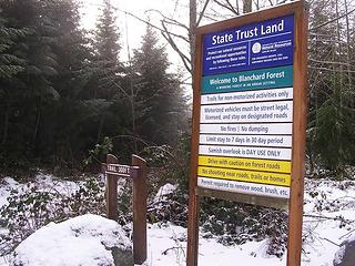 Lower parking lot trailhead 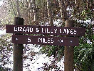 Trailhead from lower parking lot 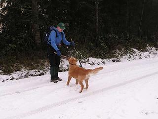 All play - all the time - always 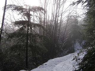 Plenty of snow on the trail at 800' 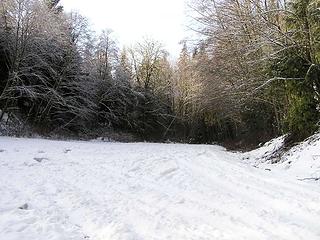 Upper parking lot 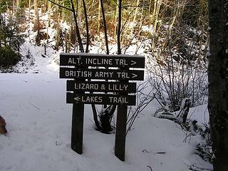 At upper parking lot 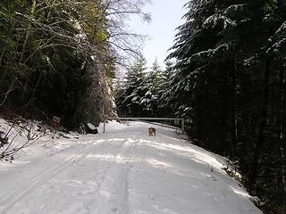 Heading up the gated road 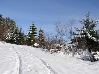 Road on eastside of Blanchard Hill  We reached the trailhead to start up the Incline/Alternate Incline trail - it's a pretty obvious left turn off of this logging road. You don't run into the actual trail juncture between Incline and Alternate Incline until you are about 50 yards up the trail. We reached the trailhead to start up the Incline/Alternate Incline trail - it's a pretty obvious left turn off of this logging road. You don't run into the actual trail juncture between Incline and Alternate Incline until you are about 50 yards up the trail.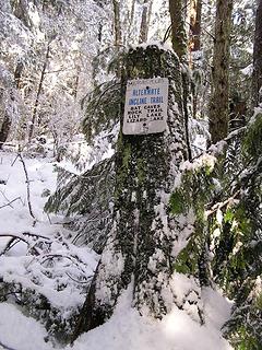 Alternate incline trail  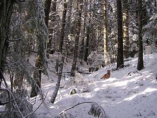 Gus on incline trail 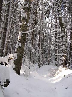 Lots of snow on trail 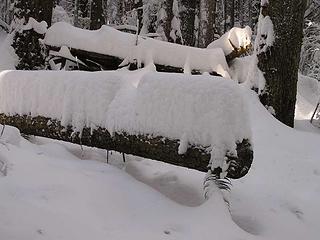 Snow depth 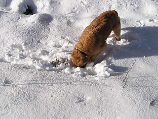 I'll find them! 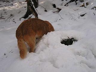 They're here somewhere 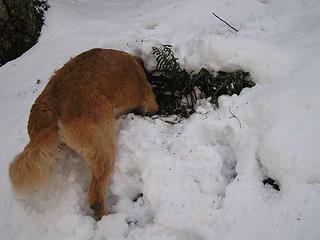 Really into it! 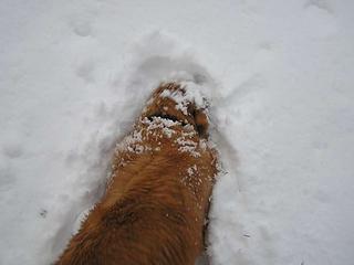 Truffle hunting 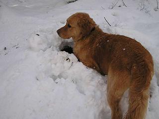 Coming up for air 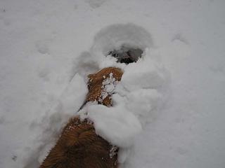 Trufflegustus in deep 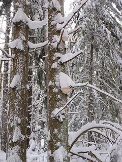 Funguscycles 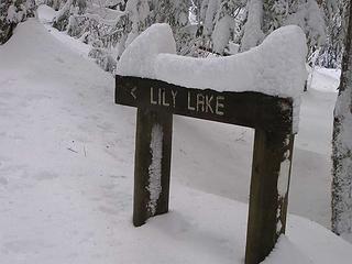 Junction on Pacific Northwest Trail 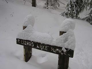 Real Lizard Lake route 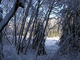 Lizard Lake 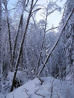 Blue sky on route to Lizard Lake 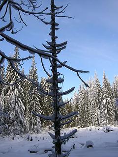 Absolutely stellar day 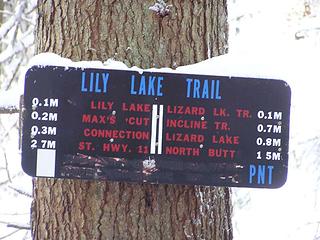 Very confusing sign - doesn't mention where/which direction 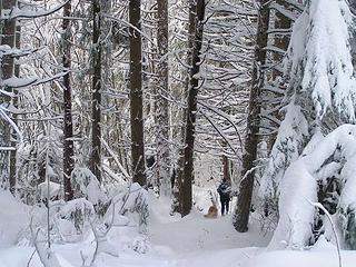 Jim and Gusto on the way to Lily Lake 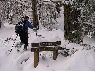 Jim K heading to the lake 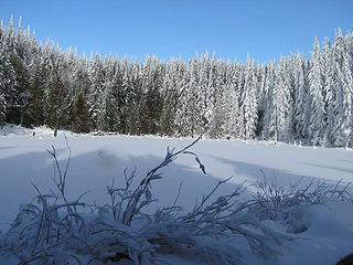 Lily Lake and blue sky 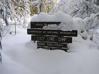 Lily Lake sign 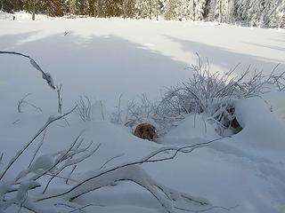 Gusto looking for a dip into Lily Lake 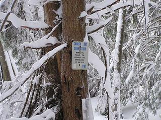 First sign identifying route to Oyster Dome 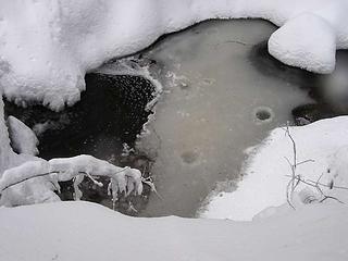 Wide shot of semi-frozen creek with snow "plumpfs" 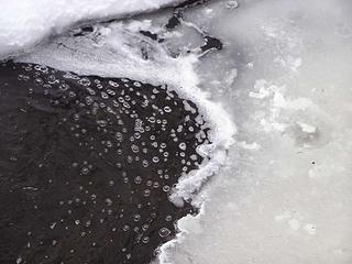 Bubbles in creek 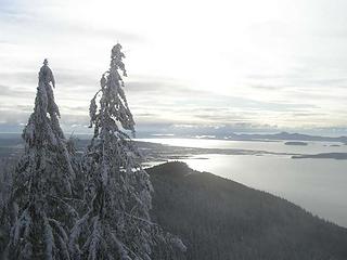 South/Southwest from Oyster Dome overlook 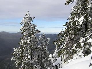 Looking North/Northwest from Oyster Dome overlook 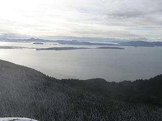 San Juans and Olympics in distance 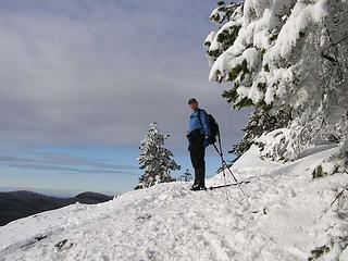 Jim K on Oyster Dome overlook 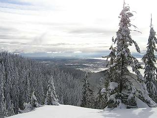 Looking south from Oyster Dome - Padilla Estuary mid-photo  Finally, two women were coming up the trail and said that we were on the right route - but we were still doubtful - because we could see Puget Sound! We were really getting a little concerned. But, after about 2.5 miles the trail took a hairpin turn east and we felt a little more assured. The trail also started losing snow - and there was little snow on the trees by now. Finally, two women were coming up the trail and said that we were on the right route - but we were still doubtful - because we could see Puget Sound! We were really getting a little concerned. But, after about 2.5 miles the trail took a hairpin turn east and we felt a little more assured. The trail also started losing snow - and there was little snow on the trees by now.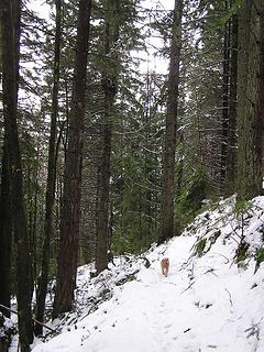 Much less snow on trail and trees on south facing slope 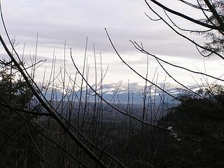 Looking South from trail back to car 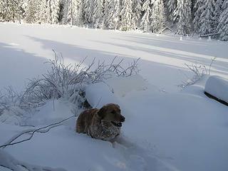 Minimal snowballs on the Gusto 
Four-paw buddy lets me tag along!
Four-paw buddy lets me tag along!
|
| Back to top |
  
|
|
seawallrunner
dilettante

Joined: 27 Apr 2005
Posts: 3307 | TRs | Pics
Location: Lotusland |
ooo nice hike and what beautiful photos. I ran this exact course a few years ago - when the leaves were back on the trees and the ferns were at least knee-high. gorgeous area. lovely to see it under the snow.
|
| Back to top |
|
|
Gabigabs
Trail Breaker

Joined: 07 Nov 2007
Posts: 841 | TRs | Pics
Location: Seattle |
|
Gabigabs
Trail Breaker
|
 Sun Feb 03, 2008 11:40 am |
|
|
Great idea for a winter trip. Nice pics.
Life is simple... Eat, Sleep, Hike!
Life is simple... Eat, Sleep, Hike!
|
| Back to top |
|
|
Kathleen
Member
Joined: 14 Feb 2007
Posts: 220 | TRs | Pics
Location: Tacoma, Washington |
|
Kathleen
Member
|
Sun Feb 03, 2008 4:57 pm |
|
|
Gusto seems to love snow as much as my dog does. I love that little nose burrowing thing they do.
|
| Back to top |
|
|
Sadie's Driver
Sadie's Driver
Joined: 24 Apr 2006
Posts: 1763 | TRs | Pics
Location: Welcome Pass |
| Kathleen wrote: | | Gusto seems to love snow as much as my dog does. I love that little nose burrowing thing they do. |
I'm counting on Mr. G making me big $$$$ when he finds those truffles!!!! 
Four-paw buddy lets me tag along!
Four-paw buddy lets me tag along!
|
| Back to top |
|
|
Trevor
Member

Joined: 31 Jan 2004
Posts: 1562 | TRs | Pics
Location: Edmonds, WA |
|
Trevor
Member
|
Sun Feb 03, 2008 6:11 pm |
|
|
Thanks for the update; still need to visit this area. Wasn't expecting quite that much snow there;seems like a good spot to go to get some snowshoing in without the worries of hazardous driving.
|
| Back to top |
|
|
the Zachster
Member

Joined: 17 Jan 2007
Posts: 4776 | TRs | Pics
Location: dog training |
What a great winter trip! You sure had more blue sky than we did in North Bend! 
"May I always be the kind of person my dog thinks I am"
"May I always be the kind of person my dog thinks I am"
|
| Back to top |
|
|
TrailPair
Member

Joined: 17 Apr 2005
Posts: 1699 | TRs | Pics
|
Even though you found more snow than you had expected being so close to Puget sound, you had a marvelous day.
I hope Gusto finds those truffels!
This thing called work is interfering with my play
This thing called work is interfering with my play
|
| Back to top |
|
|
Sadie's Driver
Sadie's Driver
Joined: 24 Apr 2006
Posts: 1763 | TRs | Pics
Location: Welcome Pass |
Four-paw buddy lets me tag along!
|
| Back to top |
|
|
goinbigg17
Member
Joined: 06 May 2007
Posts: 221 | TRs | Pics
Location: Kent/Covington |
Sounds like a great day out!
That can definitely be a confusing hike. The time I went, the mileage on the signs seemed like it was off. If you don't mind, how did you find the trail to the top of Oyster dome? The time I went, the only way we saw to get to the top was through the big boulders which have some deep holes/caves.
|
| Back to top |
|
|
Sadie's Driver
Sadie's Driver
Joined: 24 Apr 2006
Posts: 1763 | TRs | Pics
Location: Welcome Pass |
Four-paw buddy lets me tag along!
|
| Back to top |
|
|
seawallrunner
dilettante
Joined: 27 Apr 2005
Posts: 3307 | TRs | Pics
Location: Lotusland |
if you had a steep hill to climb, that was on the right path. In the race, it was called Kill Bill Hill (after the race director's first name)
|
| Back to top |
|
|
aywolfpac
Member

Joined: 27 Jan 2008
Posts: 1286 | TRs | Pics
Location: Burlington, WA |
Nice pix. It looks very similar to my trip just after Christmas. I came in from the Clayton Beach trailhead and hiked up into Lost Lake. No snow at the trailhead, just a tad around the Fragrance Lake area, and then about 16 inches around Lost Lake. No snowshoes, no skis, just my tennie runners. Makes for tough going, but it's worth it for the views.
I'm heading into that area today looking for the waterfall on Oyster Creek. We want to stay out of the snow, so we're probably just gonna slosh our way up the creek from the road. A little wetter, but much easier on the legs.
|
| Back to top |
|
|
JimK
Member

Joined: 07 Feb 2002
Posts: 5606 | TRs | Pics
Location: Ballard |
|
JimK
Member
|
Mon Feb 04, 2008 10:10 am |
|
|
Here is a link to the best map I could find:
Blanchard Hill Map
There are no rocks when coming from the east. Sounds like you were coming up from the Chuckanut side. I have not done that route so can offer no specific help. The Chuckanut Trail is shown on the above map in part. The bottom is there as well as the top. The middle is missing. Perhaps it crosses some private land?
|
| Back to top |
|
|
Sadie's Driver
Sadie's Driver
Joined: 24 Apr 2006
Posts: 1763 | TRs | Pics
Location: Welcome Pass |
|
Sadie's Driver
Sadie's Driver
|
Mon Feb 04, 2008 9:15 pm Snowy Oyster Dome
|
|
|
Thanks, Jim. The map did leave a little to be desired!!! Aywolfpac - hope you had a good trip and it wasn't too slick. Seawallrnr: Yes, steep little pitch at the end, eh? Bill deserves whatever wrath you can bestow on him!!
Four-paw buddy lets me tag along!
Four-paw buddy lets me tag along!
|
| Back to top |
|
|
|
|


 the route through the most "logical"