| Previous :: Next Topic |
| Author |
Message |
Matt
Tea, Earl Grey, Hot


Joined: 30 Jan 2007
Posts: 4307 | TRs | Pics
Location: Shoreline |
|
Matt
Tea, Earl Grey, Hot
|
 Mon Mar 03, 2008 1:31 am |
|
|
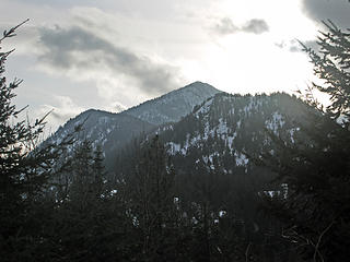
Arrowhead via East Ridge, 3/2/08
Wildernessed, Steve, GeoTom, Justus, Matt
East on railroad tracks,
Steep uphill in forest,
West on ridge to summit.
Cloudy going up,
Sunbreaks on summit,
Chiwaukum revealed.
Sore throat hoarse now,
Short trip report,
Photos posted:
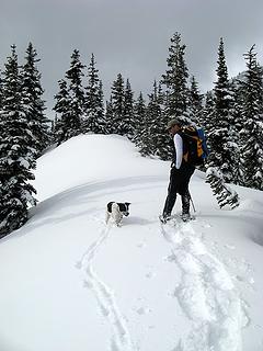 Trailbreakers 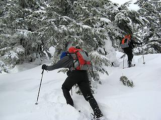 Orange packs  Up the ridge 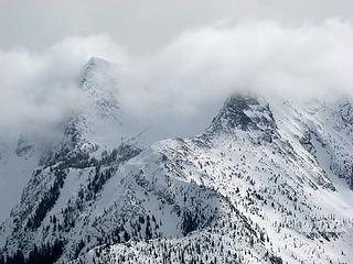 Cloud-Wrapped Chiwaukum 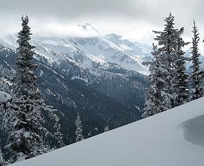 Big Chiwaukum Appears 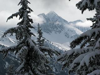 Big Chiwaukum 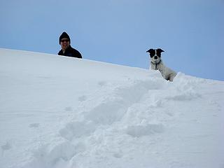 Tom & Jasper at the top 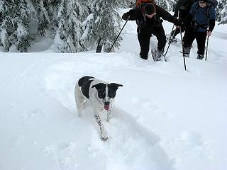 Fetching the stragglers 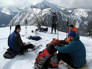 Summit Group 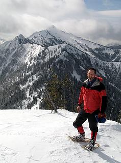 Matt 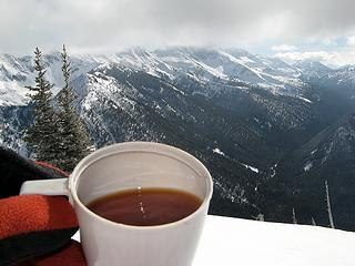 Summit Tea 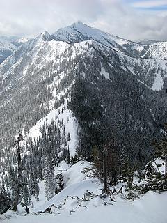 Jim Hill 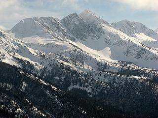 Big Chiwaukum & Snowgrass 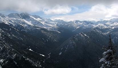 Wildhorse Creek to Frosty Pass 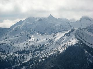 Bulls Tooth 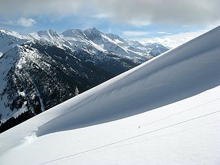 Slope & Summits 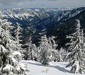 Descending 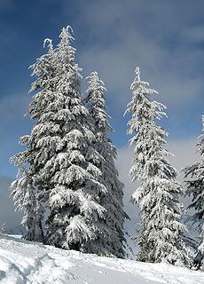 Snowy Trees 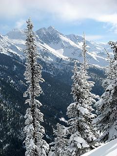 Trees & Big Chiwaukum 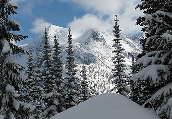 Clouds on Chiwaukums 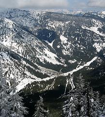 Highway, Powerline, Creek, Railroad 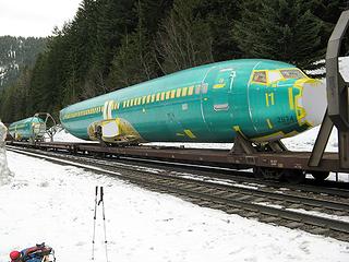 Plane on Train
As beacons mountains burned at evening. J.R.R. Tolkien
As beacons mountains burned at evening. J.R.R. Tolkien
|
| Back to top |
  
|
|
Layback
Cascades Expatriate

Joined: 16 Mar 2007
Posts: 5712 | TRs | Pics
Location: Back East |
|
Layback
Cascades Expatriate
|
Mon Mar 03, 2008 1:51 am |
|
|
Good stuff you guys! Great day to be out, no?
|
| Back to top |
|
|
puzzlr
Mid Fork Rocks

Joined: 13 Feb 2007
Posts: 7220 | TRs | Pics
Location: Stuck in the middle |
|
puzzlr
Mid Fork Rocks
|
Mon Mar 03, 2008 2:02 am |
|
|
See any snakes around those planes?
|
| Back to top |
|
|
wildernessed
viewbagger

Joined: 31 Oct 2004
Posts: 9275 | TRs | Pics
Location: Wenatchee |
You guys rock ! 
Living in the Anthropocene
Living in the Anthropocene
|
| Back to top |
|
|
GeoTom
Member
Joined: 19 May 2005
Posts: 3215 | TRs | Pics
Location: Earth |
|
GeoTom
Member
|
Mon Mar 03, 2008 9:27 am |
|
|
Some pictures from my camera can be viewed here
A few I like:
 Treat?  Last 50 feet 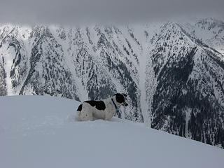 Where are those other guys? 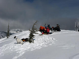 Jasper sulks 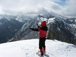 Matt performs his own stunts  It's still winter 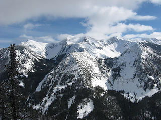 Chiwaukums  Post hike ritual  Could it be any worse?
Nice to meet Justus, Rob and Steve. Could it be any worse?
Nice to meet Justus, Rob and Steve. 
|
| Back to top |
|
|
wildernessed
viewbagger
Joined: 31 Oct 2004
Posts: 9275 | TRs | Pics
Location: Wenatchee |
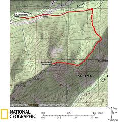
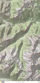 Arrowhead Route and Area 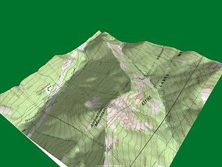 Arrowhead 3D  . We had a weather window Sunday so hoped for the best. Matt, GeoTom / Jasper, Justus, Steve, and I managed to all pull together and make a great day of it. What a group of mountain freaks. This was the first time I met Matt or GeoTom. Matt made it with some cold symptoms, I joked to him that I caught his crud via email virus. I woke up and had to take antihistamines and immodium . We had a weather window Sunday so hoped for the best. Matt, GeoTom / Jasper, Justus, Steve, and I managed to all pull together and make a great day of it. What a group of mountain freaks. This was the first time I met Matt or GeoTom. Matt made it with some cold symptoms, I joked to him that I caught his crud via email virus. I woke up and had to take antihistamines and immodium  , I was fine the night before, prior to his email. I took some extra Depends along , I was fine the night before, prior to his email. I took some extra Depends along  But anyhow, we ran the tracks back East nearly two miles, then taking the traditional route on some fairly well consolidated snow (weight dependent) made good time until we intersected the ridge at around 4100', a very smooth transition...
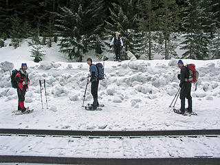 Matt, Justus, Tom, Jasper, and Steve ready to head up from the RR tracks. 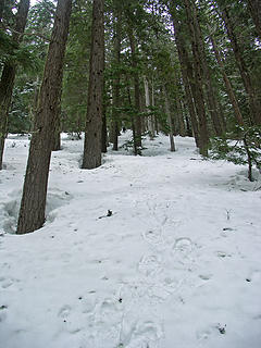 Some good consolidation lower through the trees. 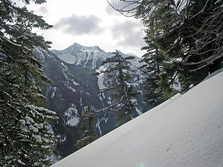 Slope and view of Chiwaukum Ridge highpoint. 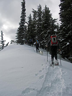 Moving along the lower ridgeline. 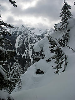 The wind sculpted ridge was a real treat along the way. 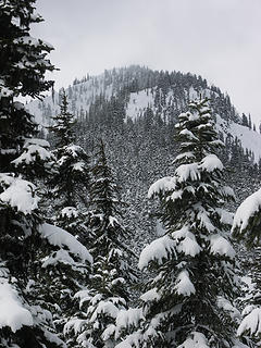 Arrowhead Summit 6030' from the lower ridge 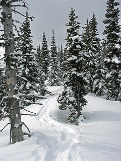 Tracks 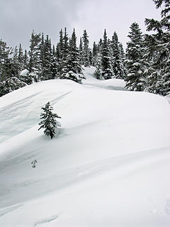 Sweet ! 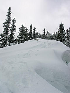 Jasper watching Tom in the trees. 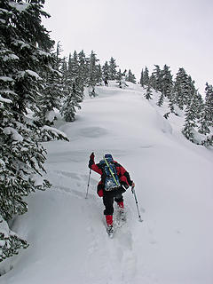 Matt moving forward. 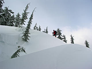 Matt gaining a drift along the ridge. 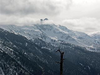 Big Chiwaukum 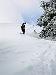 Tom and Jasper on the summit watching the rest of us file in. 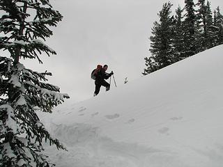 wildernessed maneuvering through ridge drifts. 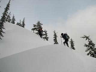 wildernessed and justus .  .
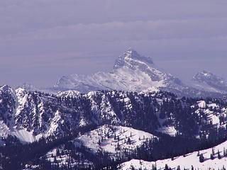
The weather we had hoped for didn't quite materialize as NOAA and others had forecasted, at least not right around our area, but we had good localized views, with some breaks here and there. Lunch was eaten, pictures taken, and a group of skiers suddenly came up from the West. .
The weather we had hoped for didn't quite materialize as NOAA and others had forecasted, at least not right around our area, but we had good localized views, with some breaks here and there. Lunch was eaten, pictures taken, and a group of skiers suddenly came up from the West.
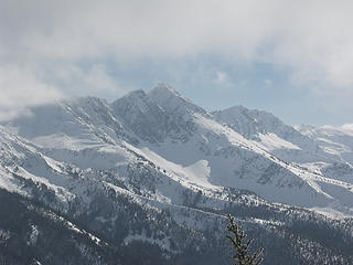 Big C and Snowgrass. 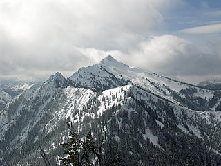 Jim Hill 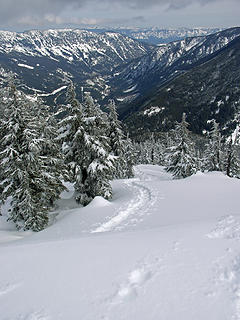 Looking back at summit tracks and Nason Ridge. 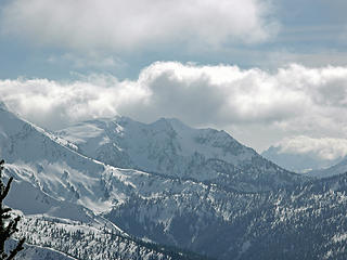 Snowgrass Mountain (?) near Frosty Pass up Wildhorse Creek. 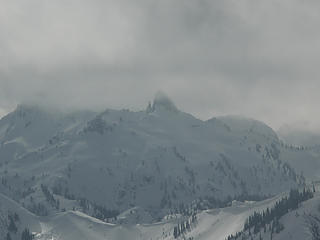 Bullstooth looks snowbound. 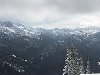 Views up Wildhorse into Chiwaukum Range. Ridge in center splits Wildhorse and Whitepine drainages. 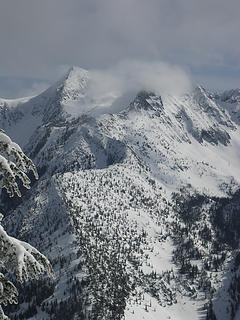 Chiwaukum Ridge highpoint. 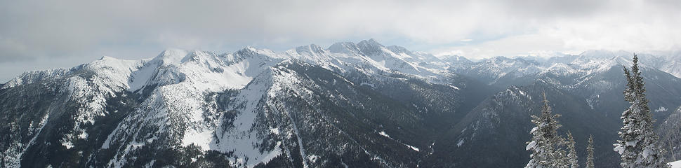 Arrowheadpano1 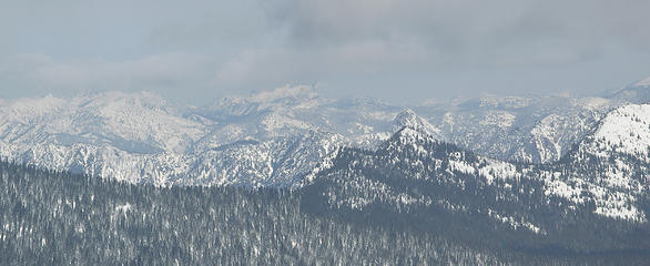 Arrowheadpano2  . We came out onto the tracks and could see the other guys up the tracks and we all made it back to the vehicles. Great trip, and nice to meet and get out with some new faces. . We came out onto the tracks and could see the other guys up the tracks and we all made it back to the vehicles. Great trip, and nice to meet and get out with some new faces.
 Ridge Route from East viewed from Rt. 2
Living in the Anthropocene
Living in the Anthropocene
|
| Back to top |
|
|
dicey
custom title

Joined: 11 May 2004
Posts: 2870 | TRs | Pics
Location: giving cornices a wider berth |
|
dicey
custom title
|
Mon Mar 03, 2008 12:34 pm |
|
|
Didja spot any skiers on Jim Hill?
I was wondering what the parking situation was these days, since they are apparently ticketing cars parked at the maint. facility. I guess parking along 2 is ok?
I did see several cars parked in pullouts along the way, and wondered if any of them belonged to you guys.
I hate the walking next to the train tracks part of this trip, but the views up top are sure nice
|
| Back to top |
|
|
dicey
custom title
Joined: 11 May 2004
Posts: 2870 | TRs | Pics
Location: giving cornices a wider berth |
|
dicey
custom title
|
Mon Mar 03, 2008 12:36 pm |
|
|
| puzzlr wrote: | | See any snakes around those planes? |
|
| Back to top |
|
|
GeoTom
Member
Joined: 19 May 2005
Posts: 3215 | TRs | Pics
Location: Earth |
|
GeoTom
Member
|
Mon Mar 03, 2008 12:37 pm |
|
|
| dicey wrote: | | Didja spot any skiers on Jim Hill?
I was wondering what the parking situation was these days, since they are apparently ticketing cars parked at the maint. facility. I guess parking along 2 is ok?
I did see several cars parked in pullouts along the way, and wondered if any of them belonged to you guys.
I hate the walking next to the train tracks part of this trip, but the views up top are sure nice |
dicey-
We did see a couple ski tracks descending from a ridge lower down on Jim Hill. Not sure if anyone actually got any good pictures of them though  We parked at a pullout on the north side of the highway, about a half-mile west of the WSDOT Berne facility. There is a wood power pole with some electrical boxes on it. It is located maybe a hundred yards west of milepost 72. No signs indicating not to park there, but who knows when that might change.
There was other parking another half mile west at a larger turnout on the south side of the highway.
We parked at a pullout on the north side of the highway, about a half-mile west of the WSDOT Berne facility. There is a wood power pole with some electrical boxes on it. It is located maybe a hundred yards west of milepost 72. No signs indicating not to park there, but who knows when that might change.
There was other parking another half mile west at a larger turnout on the south side of the highway.
|
| Back to top |
|
|
Matt
Tea, Earl Grey, Hot
Joined: 30 Jan 2007
Posts: 4307 | TRs | Pics
Location: Shoreline |
|
Matt
Tea, Earl Grey, Hot
|
Mon Mar 03, 2008 12:59 pm |
|
|
Tom, I believe that's 100 yards east of milepost 72. We saw the milepost just as we began heading west from the parking spot to to home.
As Tom noted, no signs saying you can't park there, but no signs saying you can either.
As beacons mountains burned at evening. J.R.R. Tolkien
As beacons mountains burned at evening. J.R.R. Tolkien
|
| Back to top |
|
|
Sadie's Driver
Sadie's Driver

Joined: 24 Apr 2006
Posts: 1763 | TRs | Pics
Location: Welcome Pass |
Four-paw buddy lets me tag along!
|
| Back to top |
|
|
wildernessed
viewbagger
Joined: 31 Oct 2004
Posts: 9275 | TRs | Pics
Location: Wenatchee |

 Sloan Pk. from Arrowhead.
Living in the Anthropocene
Living in the Anthropocene
|
| Back to top |
|
|
GeoTom
Member
Joined: 19 May 2005
Posts: 3215 | TRs | Pics
Location: Earth |
|
GeoTom
Member
|
Mon Mar 03, 2008 1:29 pm |
|
|
| Matt wrote: | | Tom, I believe that's 100 yards east of milepost 72. We saw the milepost just as we began heading west from the parking spot to to home.
As Tom noted, no signs saying you can't park there, but no signs saying you can either. |
East, west, yes. My internal compass was off  Matt is indeed correct. The milepost was to our west.
|
| Back to top |
|
|
wolfs
Member

Joined: 07 Oct 2004
Posts: 302 | TRs | Pics
|
|
wolfs
Member
|
Mon Mar 03, 2008 2:31 pm |
|
|
Is this the little spot immediately past the concrete trestle where the RR crosses US2? I saw a little spur road there that looked plowed wide enough to park on last time thru.
|
| Back to top |
|
|
wildernessed
viewbagger
Joined: 31 Oct 2004
Posts: 9275 | TRs | Pics
Location: Wenatchee |
 Aparking
Living in the Anthropocene
Living in the Anthropocene
|
| Back to top |
|
|
|
|
You cannot post new topics in this forum
You cannot reply to topics in this forum
You cannot edit your posts in this forum
You cannot delete your posts in this forum
You cannot vote in polls in this forum
|
Disclosure: As an Amazon Associate NWHikers.net earns from qualifying purchases when you use our link(s). |


 Was there any felonious activity on the summit? Here's what it looked like about a year ago (via a rather interesting approach)
