| Previous :: Next Topic |
| Author |
Message |
Stefan
Member


Joined: 17 Dec 2001
Posts: 5091 | TRs | Pics
|
|
Stefan
Member
|
 Mon May 19, 2008 11:23 am |
|
|
Wildcat-Derrick 5311 USGS Snoqualmie
Caroline 5885 USGS Bandera
Went out on a gorgeous Saturday with Matt B., Eric J., Dave C., and Martin S. There was a high avalanche danger, but it appears all the major avalanches are gone, and all the major cornices have disappeared. There still are some cornices
but just not any big ones. The snow was in such an excellent shape, so much so, that we did not need snowshoes, and that was a surprise to all of us with the heat.
We left the Dingford Creek trailhead at 6:30, went down the trail, crossed the bridge, walked about 100 yards west or downstream, and then went up. We came across multiple rock outcroppings but they were easy to get around. The most notable was one at 2000 feet but we went left. I even found the Old Man and His Beard piece of wood that Mike C. had done on a trip in 2003! Here is the picture:
Anyway we made our way up hitting snow in the 2500 foot range and kept going on up. I barely lead any steps on this trip because I am still a little out of shape, but I was close! Martin S., and Dave C. lead for the entire way.
Wildcat-Derrick was surmounted at 10:00a.m. with Caroline being surmounted around 12:00. Not problems along the entire route. Pretty straightforward. It was quite warm went the slight breezes did not exist
.however; I would not say it was a heat wave up there. T shirt and shorts from start to finish!
We came down the Wildcat Creek drainage and that went pretty darned good. The trick is to avoid going to both Upper Wildcat Lake and Lower Wildcat Lake and following their drainages, but remain about 100 above each of them and going over an arm just north of Lower Wildcat Lake. We even had about 900 of elevation drop in fun glissading along the upper parts of Wildcat Creek. We saw the remnants of large avalanche that probably occurred during early winter having quite a bit of tree damage all over the placethat was cool to see. Of course we hit the typical Middle Fork brush bash at 2500 feet until we came to the trail which has not been cleared out yet. The Middle Fork River was raging intensively and that a scene to see.
I am sure Matt B. will post some excellent pictures. He always does great work with the camera.
I had a great time!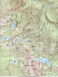 Wildcat Caroline
|
| Back to top |
  
|
|
Martin S
Member

Joined: 06 May 2007
Posts: 181 | TRs | Pics
Location: Out in the perimeter, where there are no stars |
|
Martin S
Member
|
Mon May 19, 2008 11:58 am |
|
|
Here are a few pictures I took on Saturday:
 Wild-Dare Pk from Caroline 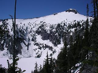 Caroline Pk from Wild-Dare 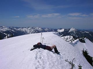 Stefan summit nap 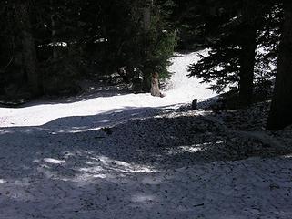 Glissading log 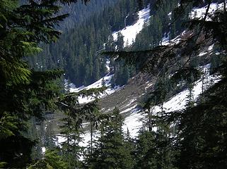 Avalanche from Wright Mtn 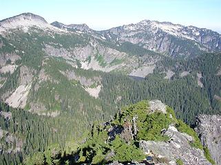 Caroline Pk from Wright Mtn 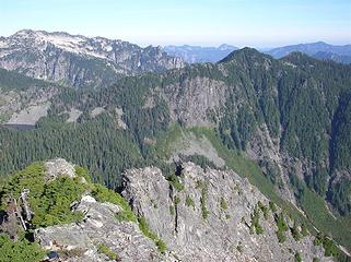 Wild-Dare from Wright Mtn 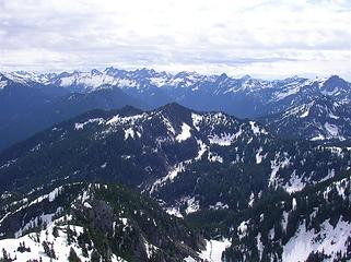 Wild-Dare from Preacher Mtn 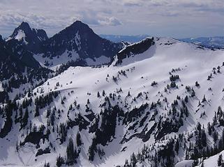 (L to R): Chair, Kaleetan, Caroline
"nothing's for certain" took the elevator down
while "anything can happen" climbed the stairs
- Ryszard Krynicki
"nothing's for certain" took the elevator down
while "anything can happen" climbed the stairs
- Ryszard Krynicki
|
| Back to top |
|
|
Randy
Cube Rat

Joined: 18 Dec 2001
Posts: 2910 | TRs | Pics
Location: Near the Siamangs |
|
Randy
Cube Rat
|
Mon May 19, 2008 12:02 pm |
|
|
Nice. Where are the beard shots?
|
| Back to top |
|
|
Matt
Tea, Earl Grey, Hot

Joined: 30 Jan 2007
Posts: 4307 | TRs | Pics
Location: Shoreline |
|
Matt
Tea, Earl Grey, Hot
|
Mon May 19, 2008 1:39 pm |
|
|
I'll dig them out of my camera tonight.
As beacons mountains burned at evening. J.R.R. Tolkien
As beacons mountains burned at evening. J.R.R. Tolkien
|
| Back to top |
|
|
Type E
Member

Joined: 19 Aug 2006
Posts: 1381 | TRs | Pics
|
|
Type E
Member
|
Mon May 19, 2008 9:20 pm |
|
|
Glad you were able to tag both summits! I was hoping to do the same thing last week but the weather didn't cooperate. I'm glad the snow stayed stable even with the high heat.
E!
|
| Back to top |
|
|
Quark
Niece of Alvy Moore

Joined: 15 May 2003
Posts: 14152 | TRs | Pics
|
|
Quark
Niece of Alvy Moore
|
Mon May 19, 2008 9:51 pm |
|
|
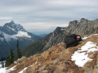
Good thing Stefan don't twitch in his sleep 
| Martin S wrote: | Stefan summit nap |
Reminds me of this nimrod who, luckily don't twitch in his sleep neither.
 Portrait of a dip (Darwin in process)
"...Other than that, the post was more or less accurate."
Bernardo, NW Hikers' Bureau Chief of Reporting
"...Other than that, the post was more or less accurate."
Bernardo, NW Hikers' Bureau Chief of Reporting
|
| Back to top |
|
|
puzzlr
Mid Fork Rocks

Joined: 13 Feb 2007
Posts: 7220 | TRs | Pics
Location: Stuck in the middle |
|
puzzlr
Mid Fork Rocks
|
Mon May 19, 2008 10:02 pm |
|
|
Great trip idea, and a little gutsy for this weekend too. Is that whole route up from the Dingford trailhead reasonable to do without snow? The ridge over to Caroline seems like it would be great in fall weather.
|
| Back to top |
|
|
Matt
Tea, Earl Grey, Hot
Joined: 30 Jan 2007
Posts: 4307 | TRs | Pics
Location: Shoreline |
|
Matt
Tea, Earl Grey, Hot
|
Mon May 19, 2008 10:36 pm |
|
|
puzzlr, the route upward would be doable but brushy. Seems like the steep traverse below the intermediate points (5082 & 5258) would be especially unpleasant. If you were doing the loop, the descent down upper Wildcat Creek would be awful without the snow, all avalanche brush. Maybe some of the others will have more info.
As far as snow risks, the course of this route was great for a day with questionable snow, because it progresses gradually from fully treed to wide open, so there is much opportunity to monitor conditions at each step along the way. In this case, the snow turned out to be surprisingly solid.
As beacons mountains burned at evening. J.R.R. Tolkien
As beacons mountains burned at evening. J.R.R. Tolkien
|
| Back to top |
|
|
Matt
Tea, Earl Grey, Hot
Joined: 30 Jan 2007
Posts: 4307 | TRs | Pics
Location: Shoreline |
|
Matt
Tea, Earl Grey, Hot
|
Mon May 19, 2008 10:43 pm |
|
|
| Quark wrote: | Good thing Stefan don't twitch in his sleep
| Martin S wrote: | Stefan summit nap |
|
Actually, that's pretty much the exact spot Stefan glissaded off of anyway.
Come to think of it, I met Stefan glissading down while I was still hiking up, so I only saw the end of the glissade, not the beginning. For all I know, he may have been asleep when the glissade started.
Anyway, it seemed to be the day for napping.
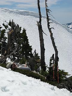 cartman napping on Caroline
As beacons mountains burned at evening. J.R.R. Tolkien
As beacons mountains burned at evening. J.R.R. Tolkien
|
| Back to top |
|
|
Justus S.
Member

Joined: 17 Nov 2004
Posts: 1298 | TRs | Pics
Location: WA |
Nice job there guys. Makes me want to take a nap. 
|
| Back to top |
|
|
Matt
Tea, Earl Grey, Hot
Joined: 30 Jan 2007
Posts: 4307 | TRs | Pics
Location: Shoreline |
|
Matt
Tea, Earl Grey, Hot
|
Tue May 20, 2008 12:32 am |
|
|
Wild Dare & Caroline, 5/17/08
Party: Matt, cartman, Stefan, Martin S, Dave Creedon
So, what to do on the hottest day of spring? How about trying to keep up with Stefan (and Creedon & Martin S) on a multi-peak jaunt? Or, more realistically, drive a separate car so cartman and I can trail behind and follow their tracks.
Anyway, it turned out to be a fine opportunity to see part of the Snoqualmie crest from a different side.
The heat turned out okay also. The snow was in great condition - slightly soft on top, but very firm underneath, almost perfect both for kicking steps uphill and for plunge stepping downhill. Temperatures were a bit hot out in the open, but refreshingly comfy for T-shirt hiking in the woods. Down at the bottom, the creeks and rivers were surging with runoff.
Vocabulary primer for this trip report:
Point 5311 between Derrick Lake & Wildcat Creek = Derrick/Wildcat = Wild Dare
Point 5885 south of Caroline lake = Caroline
4650 Col between Caroline & Wild Dare = Care Dare Col
This loop started at Dingford, went up the ridge to Wild Dare, dropped to the Care Dare Col and onward up to Caroline, returned to the col, and took Wildcat Creek back down to the MFK.
Driving the Middle Fork Road was as fun as always. Actually, its in pretty good shape, only about 50,000 or so potholes. At one point, theres an interesting little break where the road has dropped a couple feet. On one other stretch, the giant gravel was piled especially high in the centerline of the road, but its better now, because I graded it with the bottom of my Camry.
It was surprisingly cold at the Dingford trailhead. The Middle Fork was like a giant refrigerator in the valley. We crossed the bridge, took the trail a short distance north, and then headed up the Wild Dare ridge. It was steep in places, but not very brushy. Snow made travel easier above 2800 feet.
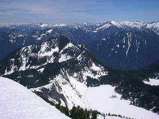
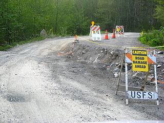 Road damage 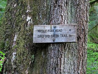 Trail sign 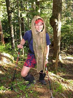 Treebeard Stefan 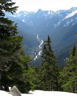 Looking back down at the Middle Fork 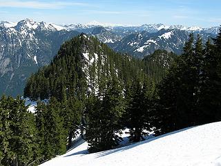 Looking back at Points 5258 & 5082 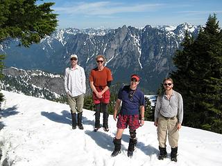 Wild Dare Summit (Martin, Creedon, Stefan, cartman) 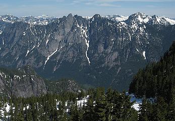 Garfield from Wild Dare summit 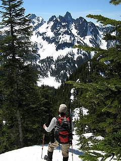 Looking toward Roosevelt & Kaleetan while departing toward the Care Dare Col 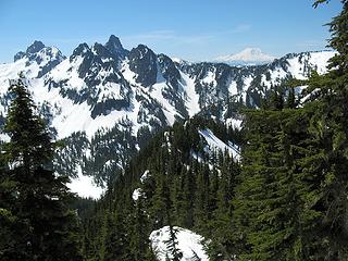 Looking down at the Care Dare Col, with Chair, Kaleetan, Rainier, & the east ridge of Caroline on the horizon 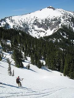 Dropping onto the west side of the ridge. 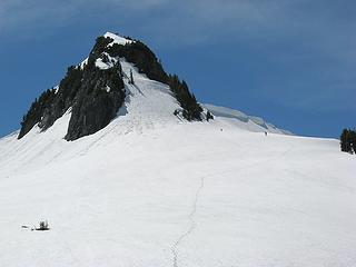 Caroline summit 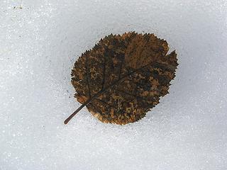 Leaf in the snow Eric napping 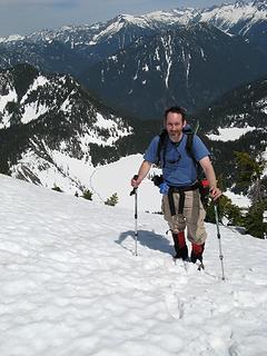 Matt on Caroline 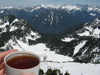 Caroline summit tea 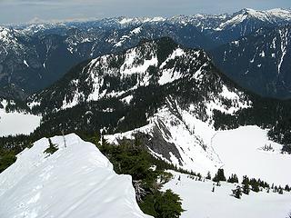 Care Dare Col, with Caroline & Wildcat Lakes 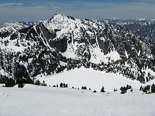 Preacher & Caroline Lake, cornice pieces at left, our tracks at right 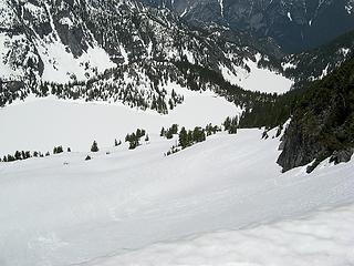 3 labels Caroline & Derrick Lakes (you can see my useless snowshoes by our tracks in the center) 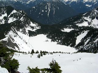 Upper & Lower Wildcat Lakes 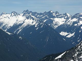 Snoqualmie Crest 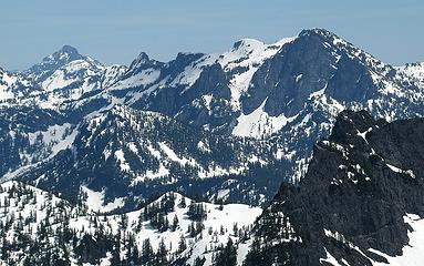 Snoqualmie Mountain 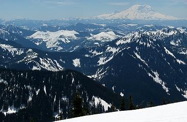 Looking south to Adams & Rainier 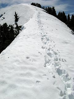 Nose of Caroline 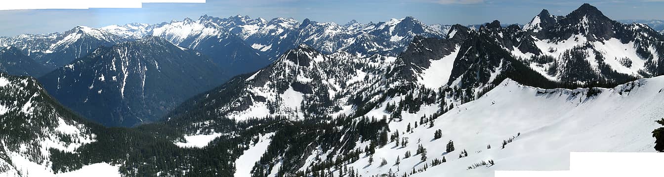 25 labels Caroline 90 degree pan of MFK peaks (labeled) 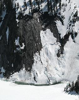 Snow slabs slipping into Upper Wildcat Lake 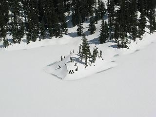 Island in Upper Wildcat, too early for swimming 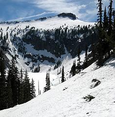 Looking back at Upper Wildcat & Caroline, the col is off the right edge of the photo 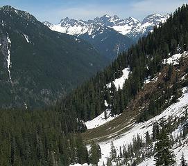 Avalanche from Wright Mtn into Wildcat Creek 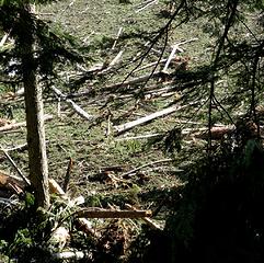 Debris near the creek 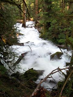 Wildcat Creek 2 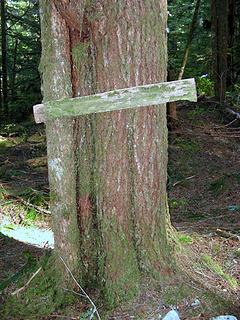 Middle Fork Trail Sign 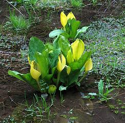 Skunk Cabbage along the way 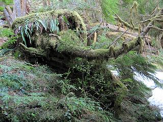 Survivor Tree! This tree has been uprooted and cut off, but it still has live foliage on its one surviving branch. 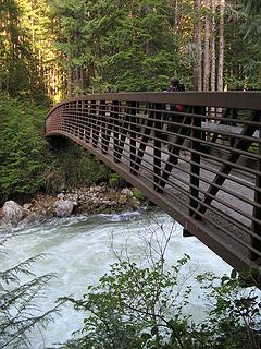 MFK Bridge 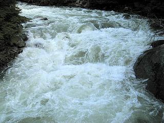 MFK Bridge View 1 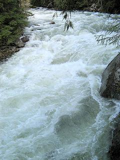 MFK Bridge View 2 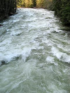 MFK Bridge View 3 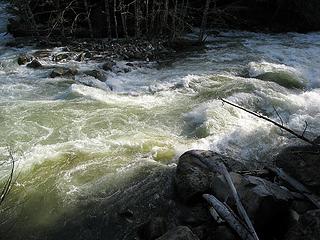 Afternoon light on the MFK 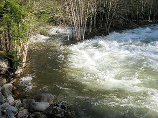 Dingford joining the MFK 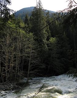 Wild Dare ridge above the MFK 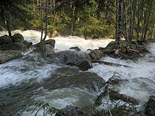 Dingford in the woods 1 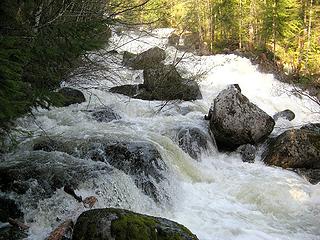 Dingford in the woods 2 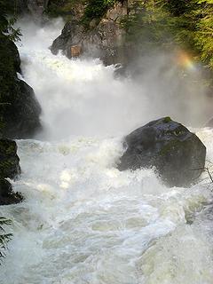 Dingford Waterfall 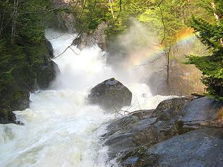 Dingford Rainbow 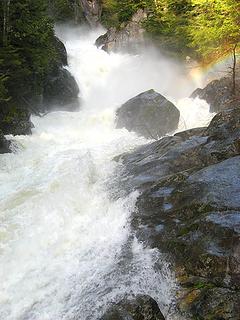 Dingford Fall & Rainbow 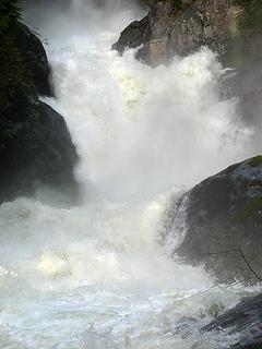 Dingford Splash 1 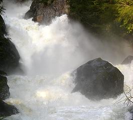 Dingford Splash 2
As beacons mountains burned at evening. J.R.R. Tolkien
As beacons mountains burned at evening. J.R.R. Tolkien
|
| Back to top |
|
|
puzzlr
Mid Fork Rocks
Joined: 13 Feb 2007
Posts: 7220 | TRs | Pics
Location: Stuck in the middle |
|
puzzlr
Mid Fork Rocks
|
Tue May 20, 2008 1:42 am |
|
|
Really outstanding photos Matt. I stared at the slabs sliding off the rock for a long time. And thanks for the earlier reply. I'm now thinking a multi-day trip would more satisfying in the summer - the lakes themselves are worth the time.
|
| Back to top |
|
|
yukon222
Member

Joined: 12 Mar 2007
Posts: 1893 | TRs | Pics
|
|
yukon222
Member
|
Tue May 20, 2008 6:43 am |
|
|
Fabulous trip photos and route description. Really made me get a feel for the terrain you guys were going thru. Rare perspective from on top too - seldom visited area. The snow slabs sliding down to Wildcat Lake 
|
| Back to top |
|
|
Stefan
Member
Joined: 17 Dec 2001
Posts: 5091 | TRs | Pics
|
|
Stefan
Member
|
Tue May 20, 2008 3:37 pm |
|
|
wow Matt. I really like your Dingford creek photos. Makes me feel as if I can hear the sound of a freight train.
|
| Back to top |
|
|
Matt
Tea, Earl Grey, Hot
Joined: 30 Jan 2007
Posts: 4307 | TRs | Pics
Location: Shoreline |
|
Matt
Tea, Earl Grey, Hot
|
Fri May 23, 2008 12:54 am |
|
|
Heres an explanation of the rather odd shape of the 360 degree panoramic I took on Caroline, where there is only one set of tracks, but it looks like three.
On the summit, there was a narrow snow-covered ridge that extended downward toward the north face of the peak. The nose blocked my view of the lakes in the foreground, so I walked about halfway down it. I took a 90 degree pan that showed the peaks ahead, but didnt get the context with Caroline. So then I took a wider pan, which included the nose itself, but made it look like there were three noses instead of one.
Caroline summit from below, with narrow nose of snow on top. The upper nose, which needs to be split apart to form the edges of the panoramic photo 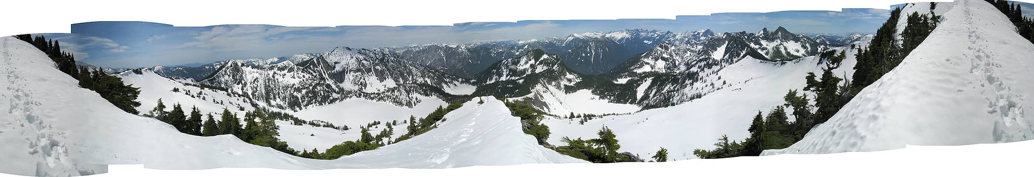 24 labels 360 degree pan from the Caroline nose.
As beacons mountains burned at evening. J.R.R. Tolkien
As beacons mountains burned at evening. J.R.R. Tolkien
|
| Back to top |
|
|
|
|
You cannot post new topics in this forum
You cannot reply to topics in this forum
You cannot edit your posts in this forum
You cannot delete your posts in this forum
You cannot vote in polls in this forum
|
Disclosure: As an Amazon Associate NWHikers.net earns from qualifying purchases when you use our link(s). |


