| Previous :: Next Topic |
| Author |
Message |
RodF
Member


Joined: 01 Sep 2007
Posts: 2593 | TRs | Pics
Location: Sequim WA |
|
RodF
Member
|
 Tue May 27, 2008 10:09 pm |
|
|
Landslide up Grand Creek?
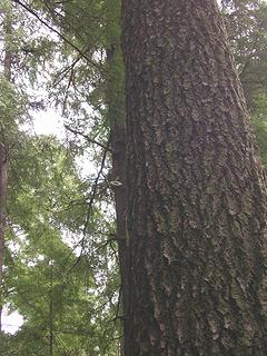
Something strange happened to the Dungeness River two weeks ago, when the warm weather hit and the river rose: overnight, it turned as white and opaque as milk! Not the normal spring runoff turbidity; you couldn't see even one inch into the water.
Checking upstream at Dungeness Forks, the Dungeness was clear, and the Gray Wolf was the source of all the turbidity. Last weekend, I got up to Three Forks and found the upper Gray Wolf and Cameron Creek are clear, but Grand Creek is still almost milky with fine silt.
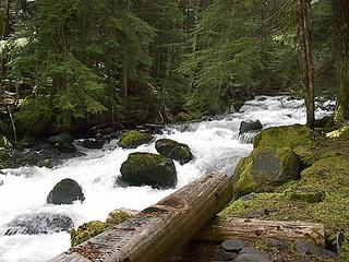 Grey Wolf River at Gray Wolf Camp: gorgeous and clear 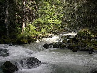 Grand Creek at Three Forks: cloudy! 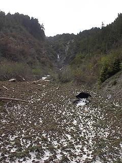 Avalanche! 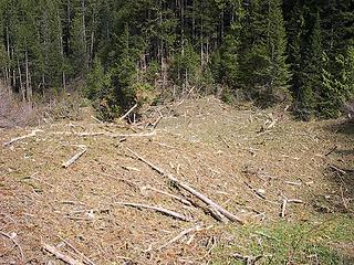 ...debris below trail 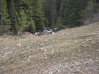 ...and into the Gray Wolf River 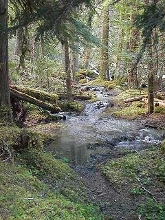 Is it a stream, or a trail? 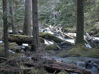 Log jam (background) diverts water onto trail (foreground) 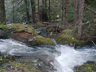 water pouring over and running down trail 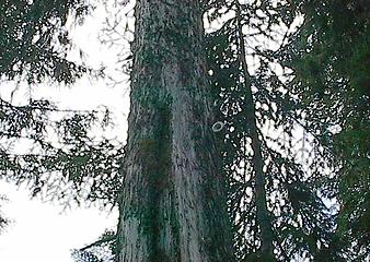 the rare Olympic Toroidal Ivory Tree Snail!
"of all the paths you take in life, make sure a few of them are dirt" - John Muir
"the wild is not the opposite of cultivated. It is the opposite of the captivated - Vandana Shiva
"of all the paths you take in life, make sure a few of them are dirt" - John Muir
"the wild is not the opposite of cultivated. It is the opposite of the captivated - Vandana Shiva
|
| Back to top |
  
|
|
wamtngal
Member

Joined: 13 Jun 2004
Posts: 2382 | TRs | Pics
Location: somewhere |
|
wamtngal
Member
|
Tue May 27, 2008 10:12 pm |
|
|
Wow, I've spotted a Rainier Toroidal Brown Tree Snail, but I didn't realize that was the scientific name. Thanks for identifying it for me.
Great pics! Just look at that avalanche debris! 
Opinions expressed here are my own.
Opinions expressed here are my own.
|
| Back to top |
|
|
captain jack
Serving suggestion

Joined: 25 May 2004
Posts: 3389 | TRs | Pics
Location: Upper Fidalgo |
I managed to snap a shot of the rare and intriguing white myself. I have really only noticed this variety on the Gray Wolf.
 Slymus Donutis 
|
| Back to top |
|
|
Phil
Member

Joined: 02 Jul 2003
Posts: 2025 | TRs | Pics
Location: Shoreline, WA |
|
Phil
Member
|
Wed May 28, 2008 6:54 am |
|
|
Wow, intense pictures Rod. Nice work 
|
| Back to top |
|
|
sequimjack
Member

Joined: 11 Aug 2007
Posts: 35 | TRs | Pics
Location: Sequim |
Rod, thanks for all the great info. I may not head for Cedar Lake any time soon!
|
| Back to top |
|
|
reststep
Member

Joined: 17 Dec 2001
Posts: 4757 | TRs | Pics
|
|
reststep
Member
|
Wed May 28, 2008 8:57 am |
|
|
That is an interesting report and pictures Rod. Thanks for posting it.
Robert Wood talks about that slide area above Camp Ellis in his guide book.
I am curious to find out what happened in Grand Valley.
"The mountains are calling and I must go." - John Muir
"The mountains are calling and I must go." - John Muir
|
| Back to top |
|
|
silence
Member

Joined: 25 Apr 2005
Posts: 4420 | TRs | Pics
|
|
silence
Member
|
Wed May 28, 2008 9:07 am |
|
|
thanks rod for all your great reporting and pix .. looks rough up there ... as i suspected ..
btw: we canceled the weekend's trip over the bogus weather reports 
PHOTOS
FILMS
Keep a good head and always carry a light bulb. Bob Dylan
PHOTOS
FILMS
Keep a good head and always carry a light bulb. Bob Dylan
|
| Back to top |
|
|
RodF
Member
Joined: 01 Sep 2007
Posts: 2593 | TRs | Pics
Location: Sequim WA |
|
RodF
Member
|
Wed Jul 16, 2008 11:50 pm |
|
|
As a follow-up on this May report, we just returned from clearing the Three Forks trail (Deer Park to Three Forks and Gray Wolf Camp). There were 58 trees across it, some tread work worth doing (two rootball tipouts, minor gravel slides, and widening a switchback for stock), and the usual limbing and brushing.
While there, we met hiker Peter Chivers, who showed us these pictures he'd just taken of the debris of a large avalanche on the upper Gray Wolf Trail at about 4400' elevation, a mile above Cedar Creek:
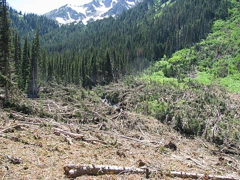 Avalanche, upper Gray Wolf trail
"of all the paths you take in life, make sure a few of them are dirt" - John Muir
"the wild is not the opposite of cultivated. It is the opposite of the captivated - Vandana Shiva
"of all the paths you take in life, make sure a few of them are dirt" - John Muir
"the wild is not the opposite of cultivated. It is the opposite of the captivated - Vandana Shiva
|
| Back to top |
|
|
Ancient Ambler
Member

Joined: 15 May 2007
Posts: 1092 | TRs | Pics
Location: Bainbridge Island |
That is some wild mess up there. Thanks for letting us know, RodF, and thanks for going in this coming weekend and following week to tame it as much as it can be tamed.
|
| Back to top |
|
|
bobbi
stillaGUAMish

Joined: 13 Jul 2006
Posts: 8012 | TRs | Pics
Location: olympics! |
|
bobbi
stillaGUAMish
|
Thu Jul 17, 2008 7:25 am |
|
|
thanks RodF.....at the other end of deer park road, on wednesday the crew is working on the obstruction point road mess.
i wished they started on monday because it was a jungle gym going through there on tuesday on my overnighter to obstruction peak area.  we truly appreciate you and the crew for getting the trails cleaned and sorted out.
thank you very much.
we truly appreciate you and the crew for getting the trails cleaned and sorted out.
thank you very much.
bobbi ૐ
"Today is your day! Your mountain is waiting. So
get on your way!" - Oh, the Places Youll Go! By Dr. Seuss
bobbi ૐ
"Today is your day! Your mountain is waiting. So
get on your way!" - Oh, the Places Youll Go! By Dr. Seuss
|
| Back to top |
|
|
sarbar
Living The Dream
Joined: 28 Jan 2002
Posts: 8055 | TRs | Pics
Location: Freeland, Wa |
|
sarbar
Living The Dream
|
Thu Jul 17, 2008 8:12 am |
|
|
Wow. That is a lot of work ahead. Nasty work. Thanks!
|
| Back to top |
|
|
Scrooge
Famous Grouse

Joined: 16 Dec 2001
Posts: 6966 | TRs | Pics
Location: wishful thinking |
|
Scrooge
Famous Grouse
|
Thu Jul 17, 2008 9:18 am |
|
|
I missed this the first time, but I'm glad I caught it now.
Great work, Rod, on both description and documentation of the damage. More evidence of what a bad winter it was. I particularly appreciate the cause and effect explanations on things like the flooded trail.
Kudos on the repair work. It does sound like you're getting it done, in spite of the extent of the damage. Maybe fixing the mess at Big Four won't be as bad as I've feared.
Something lost behind the ranges. Lost and waiting for you....... Go and find it. Go!
Something lost behind the ranges. Lost and waiting for you....... Go and find it. Go!
|
| Back to top |
|
|
RodF
Member
Joined: 01 Sep 2007
Posts: 2593 | TRs | Pics
Location: Sequim WA |
|
RodF
Member
|
Thu Jul 17, 2008 11:03 am |
|
|
| bcfc53 wrote: | | thanks RodF.....at the other end of deer park road, on wednesday the crew is working on the obstruction point road mess. |
By the way, the "Bell Hill Trail Crew" of volunteers from Sequim are clearing the ~80 logs off the Grand Ridge Trail between Deer Park and Maiden Peak this weekend, too!
This is particularly welcome news, as hikers detouring around some of those obstructions would tread on the delicate trailside alpine vegetation, which is what we all go up there to appreciate, and is slow to recover.
A large Student Conservation Association trail crew will be packing into Cameron Creek next week, to work on all the blowdown around the lower Grand Pass Trail area.
Last winter's storms really hit Olympic National Park hard. I stopped by the Park Trails office yesterday. It's buzzing like a beehive; they have crews spread all over trying to deal with it. What a year!
"of all the paths you take in life, make sure a few of them are dirt" - John Muir
"the wild is not the opposite of cultivated. It is the opposite of the captivated - Vandana Shiva
"of all the paths you take in life, make sure a few of them are dirt" - John Muir
"the wild is not the opposite of cultivated. It is the opposite of the captivated - Vandana Shiva
|
| Back to top |
|
|
bobbi
stillaGUAMish
Joined: 13 Jul 2006
Posts: 8012 | TRs | Pics
Location: olympics! |
|
bobbi
stillaGUAMish
|
Thu Jul 17, 2008 11:18 am |
|
|
also the trail crew did some clearing along the appleton pass trail. how much, i don't know.
bobbi ૐ
"Today is your day! Your mountain is waiting. So
get on your way!" - Oh, the Places Youll Go! By Dr. Seuss
bobbi ૐ
"Today is your day! Your mountain is waiting. So
get on your way!" - Oh, the Places Youll Go! By Dr. Seuss
|
| Back to top |
|
|
ChrisSJI
Member
Joined: 23 Jun 2008
Posts: 361 | TRs | Pics
Location: San Juan Island |
|
ChrisSJI
Member
|
Thu Jul 17, 2008 1:35 pm |
|
|
My wife and went up the Upper Gray Wolf and up to Cedar Lake on 4th of July weekend. I actually didn't think the avalanche was all that bad to navigate.
When you come to the avalanche there is a big tangle of downed trees, like a severe blow-down. We hiked up and around them (not more than a 50" detour off the trail) and popped right back on the trail. At the chute the trial bends around, and comes to a narrow point to cross at the creek. Then its just a small scramble over the snow and you're back on the trail. 1/4 of lost trail is an overstatement IMO. Perhaps only a 100 yards?
Maybe its more difficult to navigate now that more snow has melted but I didn't see any need to hike as far around the avalanche as Will did.
Cedar Lake trail wasn't bad either. Only a couple of blowdowns to climb over. The valley up there must be more sheltered from the wind. I'm sure its ice free by now. The campsite at the outlet is melted out as well.
The most treturous (sp?) part of the trail is the just-started footlog across the creek that is steep and only planed down for about 8 feet. It was wet on our way down so we opted for crossing over the logjam just upstream from the log.
I'll try to get pictures posted in the next couple of days for your reference.
Thanks for all of the hard work RodF. You're crew certainly has its work cut out for it!
|
| Back to top |
|
|
|
|
You cannot post new topics in this forum
You cannot reply to topics in this forum
You cannot edit your posts in this forum
You cannot delete your posts in this forum
You cannot vote in polls in this forum
|
Disclosure: As an Amazon Associate NWHikers.net earns from qualifying purchases when you use our link(s). |


