| Previous :: Next Topic |
| Author |
Message |
Conrad
Meadow bagger


Joined: 25 Aug 2006
Posts: 2298 | TRs | Pics
Location: Moscow, ID |
|
Conrad
Meadow bagger
|
 Sat Aug 02, 2008 2:52 pm |
|
|
The Goat Rocks Crest is the highest (and scariest, for us acrophobes) section of the Pacific Crest Trail in Washington. 7/27 (Su) thru 7/29 (Tu) I backpacked from the N Fk Tieton R trailhead up to the PCT, then S on the PCT over the Goat Rocks Crest as far S as Snowgrass Flat, then returned back N.
Attractions: Steep rocky snowfield-clad mountains all around (and under foot). Big distant views of Mts. Rainier, St. Helens, Adams. Flowers and little creeks in pretty meadows.
Warning: Lots of steep, narrow, gravel-strewn-slippery trail above big drops on the Goat Rocks Crest. My boot soles weren't bald, but their tread was pretty well-rounded; maybe newer boots would've helped.
Snow: (If it's no longer 2008 when you read this, note 2008 was a very heavy snow year.) Lots of snowfields covering sections of trail, but mostly easy enough to walk on. One problematic steep icy snowfield, which will be told.
Crowds: Only certain places. Several hiker and horse parties between Tieton Pass and McCall Basin. Almost noone from McCall Basin to Packwood Glacier. Fairly busy from Packwood Glacier to my turnaround near Snowgrass Flat.
Bugs: Plentiful mosquitos in the forested zone from the trailhead to McCall Basin -- but it was cloudy and cool both days I was there, which I think makes them worse. No bugs at all up higher in the meadow, snow and rock zones.
Water: Several watering spots from the trailhead to almost Tieton Pass. No "attractive" water from Tieton Pass to the ridge a mile W of McCall Basin. Plenty of water (and snow) from that ridge to almost Elk Pass. No water on the Goat Rocks Crest from Elk Pass to Packwood Glacier. Plenty of water S of Packwood Glacier to Snowgrass Flat.
Day 1: In to Base Camp below Elk Pass
Left Moscow, ID at 2 AM and reached the end of the N Fk Tieton R road, S of US Hwy 12 near White Pass, at 7 AM. Recreation pass (e.g. Northwest Forest Pass) required for parking.
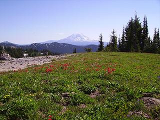
Trail 1118 up to Tieton Pass, and then S on the PCT to the McCall Basin turnoff, is an unremarkable woods slog. From the McCall Basin turnoff I ascended W on the PCT to a large bench 1/2 mile E of Elk Pass at 6000', where I found good camping -- plentiful water, a sandy tent site with a view, no bugs -- amid nice meadows:
I found my camp around 3 PM so I had a nice relaxed evening and went to bed at 7 PM, because I'd been up since 2 AM and there was a lot I wanted to see tomorrow.
Day stats: 9 miles, 3000' gain.
Day 2: Day-hike Goat Rocks Crest to Snowgrass
I was on the PCT southbound at 6 AM. First I ascended the bench W to Elk Pass:
Here's Elk Pass, looking ahead (S) along the Goat Rocks Crest to Old Snowy on the right:
From Elk Pass I continued S on the Crest (did I mention it was scary?). After 1.5 miles, the PCT splits. The "high route" climbs straight up the ridge spine, above the cliff above Packwood Glacier, almost to the top of Old Snowy; the "low route" continues level, contouring below that cliff and above the glacier. (My old 100 Hikes description of the low route crossing the glacier appears to be obsolete; apparently the glacier has shrunk since then.)
So first I tried the high route. But after a minute it just seemed to disappear in steep dirt/shale for a bit, and I thought it must not be the upper PCT route, which I thought was supposed to be horseable (I was wrong; it was the upper PCT route). So then I tried the low route. But then I hit a snowfield (the 1st snow I'd found since Elk Pass); fairly steep, with a long drop, and ice-hard in the shade at 9 AM; no way I was going to try it at that hour. So I gave up and headed back N.
But as I headed back N, I saw an off-trail route a couple hundred feet below the PCT which I thought I could use to get around that snowfield. I went for it: first sidehilling down steep dirt; then down a few yards of steep hard snow, where I slipped, slid, and bloodied a knuckle before stopping in the steep scree below; then contouring S on gentler snow and rocks below the PCT; then back up a strip of steep meadow to the PCT, now on the S side of that snowfield, only 3 hours after first reaching its N side!
Finally I continued S, reaching the end of the "scary Goat Rocks Crest" section at the ridge just S of Packwood Glacier. Here I found the south junction of the low route / high route split. I continued S through lovely meadows:
 Fork w/ Snowgrass Trail, Mt. Adams  Then I returned N to Tieton Pass. Here I took a new route home; I continued N on the PCT to Hidden Spring Trail 1117. No water on this section except some shallow marshy lakes.
Then I took Hidden Spring Trail E and down (and I mean down) back to Trail 1118. Hidden Spring is a nice strong spring; there's a campsite on the main trail from which a well-beaten side trail leads down to the spring. And if you want to carry water a few minutes to camp, a bit further S on the main trail is a gorgeous large camp overlooking a big drop and the N Fk Tieton valley.
But here I had a last nasty surprise; Hidden Spring Trail plunges almost straight down that big drop a couple of hundred feet before gentling (a bit). I think it's the steepest, slipperiest bare-dirt gully I've ever seen called a "trail". I had to turn around and face the slope to keep my feet; nothing to grab onto or stop yourself on. But finally I made it down, and back to Trail 1118, and finally back to my car.
Day stats: 12 miles, lots of steep drop.
Then I returned N to Tieton Pass. Here I took a new route home; I continued N on the PCT to Hidden Spring Trail 1117. No water on this section except some shallow marshy lakes.
Then I took Hidden Spring Trail E and down (and I mean down) back to Trail 1118. Hidden Spring is a nice strong spring; there's a campsite on the main trail from which a well-beaten side trail leads down to the spring. And if you want to carry water a few minutes to camp, a bit further S on the main trail is a gorgeous large camp overlooking a big drop and the N Fk Tieton valley.
But here I had a last nasty surprise; Hidden Spring Trail plunges almost straight down that big drop a couple of hundred feet before gentling (a bit). I think it's the steepest, slipperiest bare-dirt gully I've ever seen called a "trail". I had to turn around and face the slope to keep my feet; nothing to grab onto or stop yourself on. But finally I made it down, and back to Trail 1118, and finally back to my car.
Day stats: 12 miles, lots of steep drop.
|
| Back to top |
  
|
|
kbatku
Questionable hiker

Joined: 17 Sep 2007
Posts: 3330 | TRs | Pics
Location: Yaquima |
|
kbatku
Questionable hiker
|
Sat Aug 02, 2008 11:45 pm Great report - great hike!!
|
|
|
Good to know things are cleared out up there - thanks!! The Hidden Springs trail is hideous - try going UP it some time... 
|
| Back to top |
|
|
Conrad
Meadow bagger
Joined: 25 Aug 2006
Posts: 2298 | TRs | Pics
Location: Moscow, ID |
|
Conrad
Meadow bagger
|
Mon Aug 04, 2008 7:42 am |
|
|
|
| Back to top |
|
|
kbatku
Questionable hiker
Joined: 17 Sep 2007
Posts: 3330 | TRs | Pics
Location: Yaquima |
|
kbatku
Questionable hiker
|
Mon Aug 04, 2008 7:59 am Back at you
|
|
|
Bumpity bump
PS: Did you post the TR to the WTA site?
|
| Back to top |
|
|
Conrad
Meadow bagger
Joined: 25 Aug 2006
Posts: 2298 | TRs | Pics
Location: Moscow, ID |
|
Conrad
Meadow bagger
|
Mon Aug 04, 2008 9:00 am Re: Back at you
|
|
|
| kbatku wrote: | | Did you post the TR to the WTA site? |
I thought you couldn't post the "same" TR on WTA because they have restrictions on length, photos, format, whatever.
|
| Back to top |
|
|
Tag Man
side hiller

Joined: 20 May 2008
Posts: 602 | TRs | Pics
Location: Where the roots all twist... |
|
Tag Man
side hiller
|
Mon Aug 04, 2008 10:09 am |
|
|
Thanks for the report Conrad, its appreciated. I want to try this one this year, probably in early September.
|
| Back to top |
|
|
silence
Member

Joined: 25 Apr 2005
Posts: 4420 | TRs | Pics
|
|
silence
Member
|
Mon Aug 04, 2008 10:01 pm |
|
|
yeah ... just as i suspected .. thanks for reinforcin the fear factor  .. but hey you got er done .. nice going .. this one's been on our list .. someday the goat rocks and that stretch of the pct and more .. so much to see and so much to do .. .. but hey you got er done .. nice going .. this one's been on our list .. someday the goat rocks and that stretch of the pct and more .. so much to see and so much to do ..
PHOTOS
FILMS
Keep a good head and always carry a light bulb. Bob Dylan
PHOTOS
FILMS
Keep a good head and always carry a light bulb. Bob Dylan
|
| Back to top |
|
|
Conrad
Meadow bagger
Joined: 25 Aug 2006
Posts: 2298 | TRs | Pics
Location: Moscow, ID |
|
Conrad
Meadow bagger
|
Mon Aug 04, 2008 10:12 pm |
|
|
| Tag Man wrote: | | I want to try this one this year, probably in early September. |
By September, I suspect you can take the low route at Packwood Glacier with no steep snowfields, and save some of the steep slippery trail of the high route (unless you want to get up near the top of Old Snowy).
|
| Back to top |
|
|
silence
Member
Joined: 25 Apr 2005
Posts: 4420 | TRs | Pics
|
|
silence
Member
|
Mon Aug 04, 2008 10:22 pm |
|
|
| Conrad wrote: | | (unless you want to get up near the top of Old Snowy). |
Now wouldn't that be a good choice .. i mean Old Snowy -- esp then??
PHOTOS
FILMS
Keep a good head and always carry a light bulb. Bob Dylan
PHOTOS
FILMS
Keep a good head and always carry a light bulb. Bob Dylan
|
| Back to top |
|
|
|
|
You cannot post new topics in this forum
You cannot reply to topics in this forum
You cannot edit your posts in this forum
You cannot delete your posts in this forum
You cannot vote in polls in this forum
|
Disclosure: As an Amazon Associate NWHikers.net earns from qualifying purchases when you use our link(s). |


