| Previous :: Next Topic |
| Author |
Message |
Matt
Tea, Earl Grey, Hot


Joined: 30 Jan 2007
Posts: 4307 | TRs | Pics
Location: Shoreline |
|
Matt
Tea, Earl Grey, Hot
|
 Sat Nov 15, 2008 4:19 pm |
|
|
Picket Pass Traverse, via Little Beaver Trail, Whatcom Pass, Whatcom Peak, Challenger Col, Phantom Arm, Pickell Pass, Swiss Peak, Picket Pass, McMillan Cirque, Elephant Butte Bypass, Stetattle Ridge, Sourdough Trail.
Dates: July 19-27, 2008
Party: Matt Burton, Mike Torok, Billie Butterfield, Paul Bakke
I'm finally catching up on this report on my big trip from last summer.
This report covers the first three days of the trip. Other days will follow in separate reports.
Introduction
Our Picket Pass traverse was challenging and rewarding in equally intense proportions -- strenuously demanding in its travel, provocatively magnificent in its terrain, and personally satisfying in its accomplishment -- overall an outstanding mountaineering experience for me.
Picket Pass
Above the wilderness between the Skagit River and Mt. Baker rise the jagged, ice-carved peaks of the Picket Range, wearing such stirring names as Fury, Phantom, Terror, and Challenger. The jumble is roughly organized in the southern, or Terror, group and the northern, or Fury, group two fortresses by cliffs and jungle. (Fred Beckey, Challenge of the North Cascades)
Just as Beckey describes, the Pickets form two distinct serrated walls of rock, each arching east-west -- the northern group centered on Fury, and the southern group centered on Terror.
In between, the groups are connected at only one place, a single narrow steep rib of rock stretched thin and tight between the high ranges north and south, with the deep divides of McMillan Creek and Goodell Creek leaving only chasms of empty space to the east and west.
Physically, Picket Pass is a bridge of steeply carved rock,
. . . standing suspended in exaggerated relief between the heights of Fury and Terror.
Spiritually, Picket Pass is a passage of intensely focused experience,
. . . traveling suspended between the raging majesty of the place and the fearful challenge of its terrain.
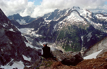
I got my first view of Picket Pass in July 2001, when I climbed West McMillan Spire. It was, and still is, the wildest piece of terrain I have seen in the Cascades.
East side of Picket Pass, viewed from West McMillan (2001)
 7 labels Picket Pass (plus McMillan-Goodell Pass, Pickell Pass, & Fury) (labeled) 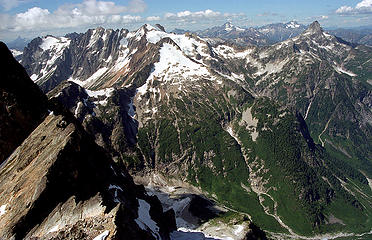 5 labels Picket Pass (plus Fury, Luna, & McMillan Creek) (labeled) 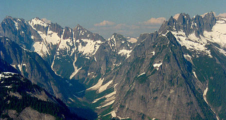 7 labels Picket Pass from Mystery Ridge (labeled) 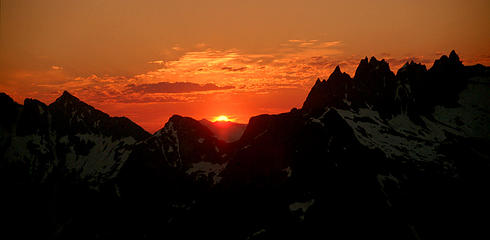 Picket Pass sunrise from Mystery Ridge 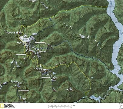 Pickets Trips Map 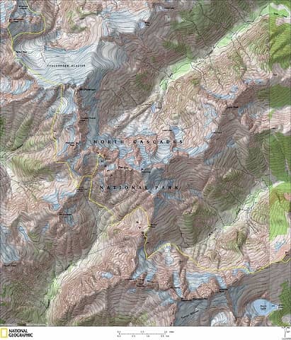 Core of the Pickets Traverse 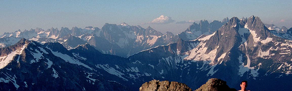 10 labels Pickets Traverse, viewed from Berdeen the traverse enters via Challenger on the left, traverses in along the front side of the lefthand peaks, crosses Picket Pass in the center, and traverses out along the back side of the righthand peaks. (Foreground is Mystery Ridge & Despair.) (labeled) 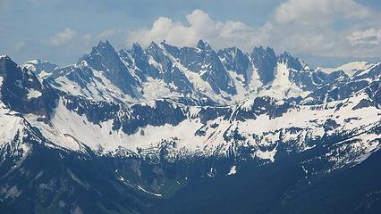 11 labels Southern Pickets, viewed from Hozomeen our route crosses Picket Pass at far right, traverses in front of all the southern peaks, and exits across the corniced col east of McMillan at left. (labeled) 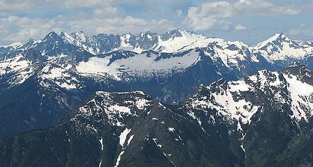 9 labels Northern Pickets, viewed from Hozomeen our route comes up Little Beaver Creek deep in the foreground, crosses Challenger at the far right, and traverses behind all the northern peaks to Picket Pass at far left. (labeled) 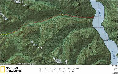 Day 1 Map (red line) 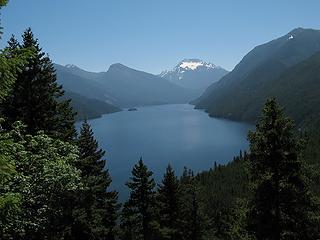 Ross Lake from start of Little Beaver trail 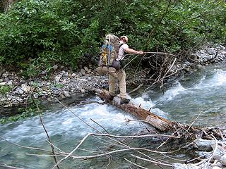 Mike crossing Redoubt Creek 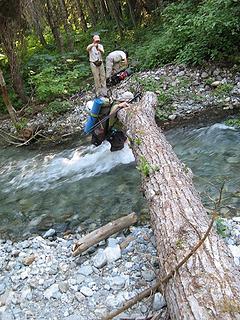 Paul fording Redoubt Creek 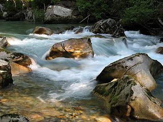 Little Beaver Creek flowing past our camp 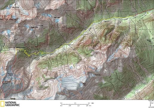 Day 2 Map (yellow line) 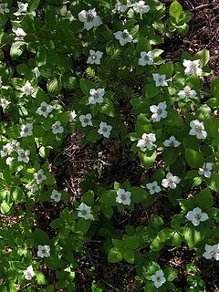 Bunchberry flowers along the trail 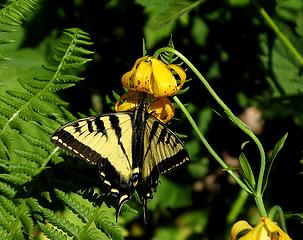 Tiger Swallowtail on Tiger Lily 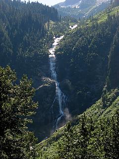 Waterfall from Wiley Ridge 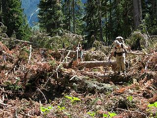 Avalanche debris 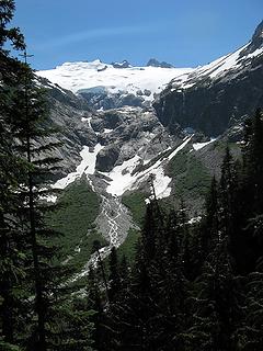 Challenger 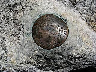 Whatcom Pass benchmark 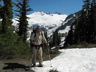 Matt in his safari outfit at Whatcom Pass 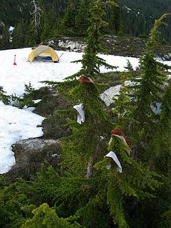 Laundry tree at Whatcom Camp 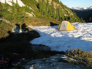 Shadow campers at Whatcom Camp 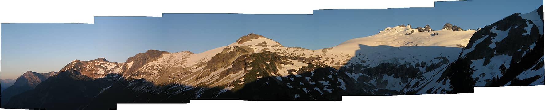 Wiley Ridge, Challenger, Whatcom shoulder 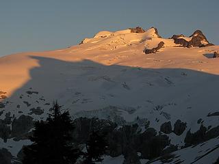 Whatcom Shadow on Challenger Glacier 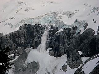 Challenger Ice Avalanche 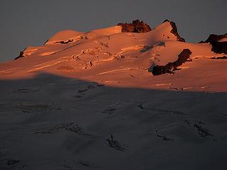 Challenger sunset 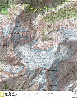 Day 3 Map (red line) 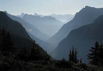 Early morning view down Little Beaver valley toward Hozomeen peaks 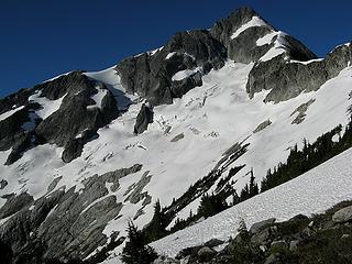 Beginning of the traverse 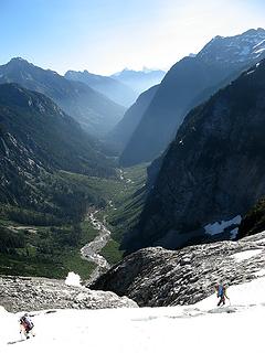 Above Little Beaver 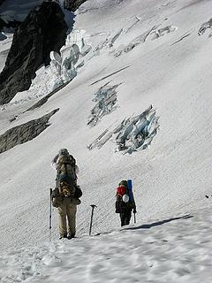 Onto the glacier 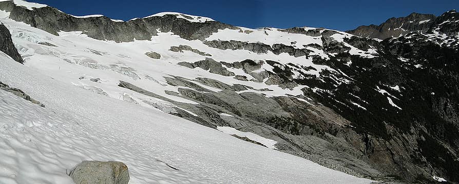 Looking back along the traverse to Whatcom Pass 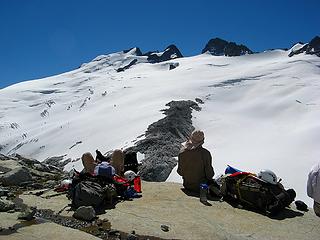 Taking a break on the south flank of Whatcom Peak 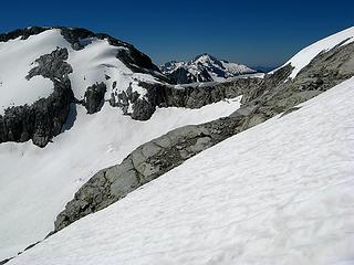 Coming around to Perfect Pass 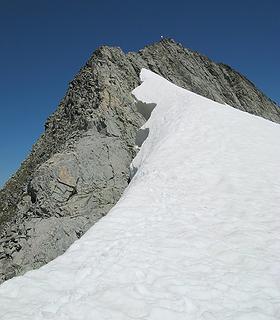 Whatcom summit crest 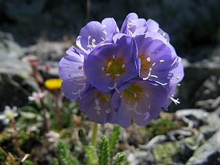 Flower on the crest. 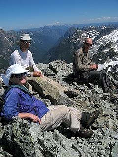 Billie, Mike & Paul on Whatcom summit 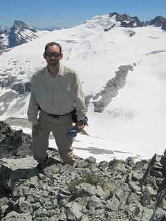 Matt on Whatcom summit, with Luna & Challenger (and a hint of Southern Pickets beyond Challenger) 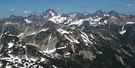 Bear, Redoubt, Custer, Rahm, Spickard, NW Mox, SE Mox 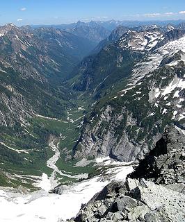 Little Beaver Valley, Hozomeen Peaks, Wiley Ridge 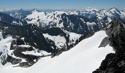 Perfect Pass, Triumph, Despair, Mystery Ridge, Pioneer Ridge, Bacon, Hagan, Blum 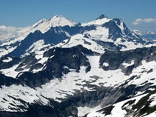 Baker & Shuksan 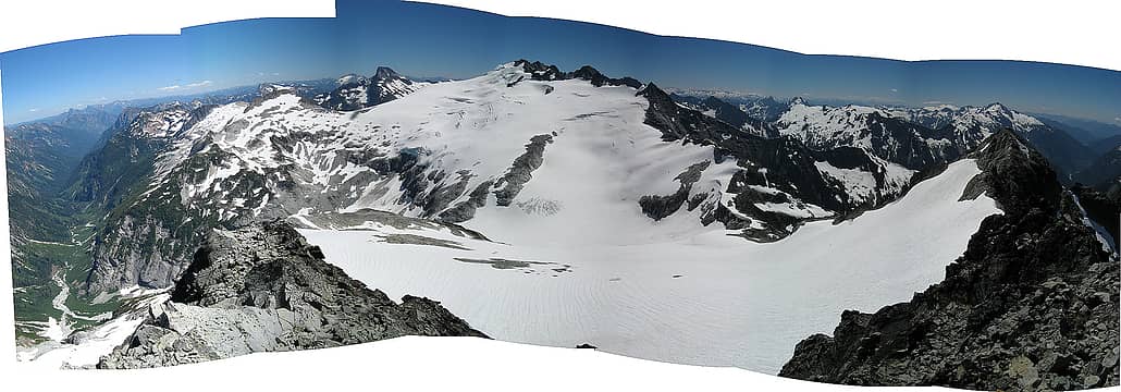 Whatcom summit pan 1, Little Beaver to Baker River 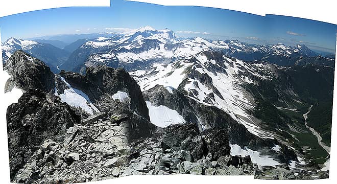 Whatcom summit pan 2, Baker River to Brush Creek 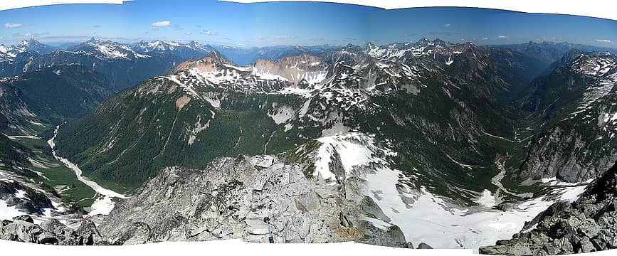 Whatcom summit pan 3, Brush Creek to Little Beaver 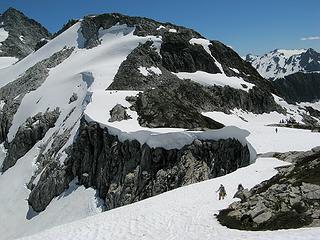 1 label Crossing Perfect Pass (notice the tent on the rocks?) 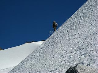 Mike kicking steps up from Perfect Pass 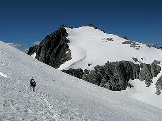 Billie on the Challenger side of Perfect Pass 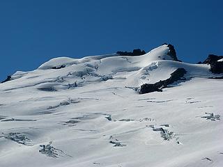 1 label First rope team on Challenger Glacier (four dots at left) 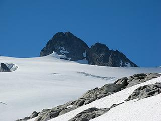 1 label Second rope team on Challenger Glacier (four dots in center) 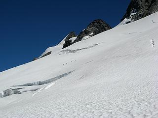 Rope team approaching us 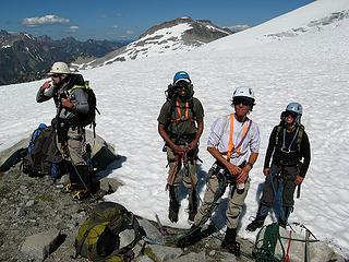 Doug, Shail, Dicey, & Yana 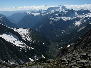 Looking down Mineral Creek & Baker River from the meeting spot 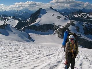 Paul ascending the Challenger Glacier, with Perfect Pass & Whatcom Peak (being poked by Slesse) 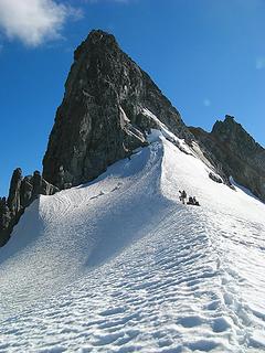 The arête at the crest of the col 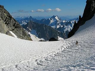 Mike descending into the col, with Crowder, Triumph, & Despair 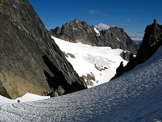 Crooked Thumb & Phantom 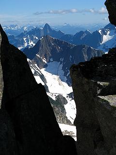 Crowder & Triumph viewed through the notch 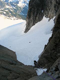 Mike rappelling from the notch 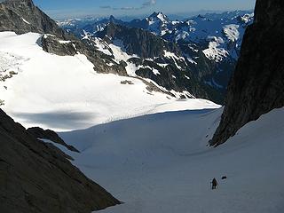 Hiking down onto the glacier south of the col 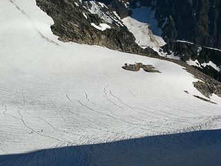 Paul & Billie heading toward the rock island where we'll camp. 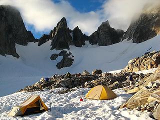 South Challenger Camp 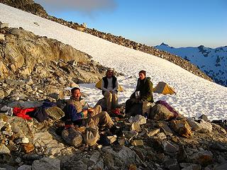 Dinner at South Challenger Camp 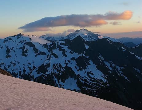 Evening light on Bacon & Pioneer Ridge 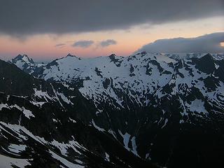 Evening light above Despair, Mystery Ridge, & Pioneer Ridge 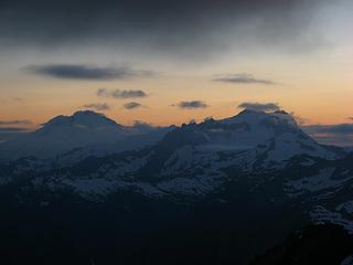 Baker & Shuksan at sunset
As beacons mountains burned at evening. J.R.R. Tolkien
As beacons mountains burned at evening. J.R.R. Tolkien
|
| Back to top |
  
|
|
raising3hikers
Member

Joined: 21 Sep 2007
Posts: 2344 | TRs | Pics
Location: Edmonds, Wa |
Nice TR  I hope to go there within the next year or so. Your pictures are really good I hope to go there within the next year or so. Your pictures are really good 
|
| Back to top |
|
|
Magellan
Brutally Handsome

Joined: 26 Jul 2006
Posts: 13116 | TRs | Pics
Location: Inexorable descent |
|
Magellan
Brutally Handsome
|
Sat Nov 15, 2008 11:25 pm |
|
|
|
| Back to top |
|
|
Backpacker Joe
Blind Hiker

Joined: 16 Dec 2001
Posts: 23956 | TRs | Pics
Location: Cle Elum |
Impressive. You krazie klimbers are a hardy bunch to be sure. Nice work Matt and friends.
"If destruction be our lot we must ourselves be its author and finisher. As a nation of freemen we must live through all time or die by suicide."
Abraham Lincoln
"If destruction be our lot we must ourselves be its author and finisher. As a nation of freemen we must live through all time or die by suicide."
Abraham Lincoln
|
| Back to top |
|
|
Yana
Hater

Joined: 04 Jun 2004
Posts: 4212 | TRs | Pics
Location: Out Hating |
|
Yana
Hater
|
Sun Nov 16, 2008 1:03 am |
|
|
Wow, Matt. Your photos of the Pickets are exquisite.
PLAY SAFE! SKI ONLY IN CLOCKWISE DIRECTION! LET'S ALL HAVE FUN TOGETHER!
PLAY SAFE! SKI ONLY IN CLOCKWISE DIRECTION! LET'S ALL HAVE FUN TOGETHER!
|
| Back to top |
|
|
seawallrunner
dilettante

Joined: 27 Apr 2005
Posts: 3306 | TRs | Pics
Location: Lotusland |
this TR is a better read than the Sunday New York Times  and your maps and photos are exquisite. Thank you so much for sharing these !!
Although I must say that I cannot see that tent on the rock... could you mark it? and your maps and photos are exquisite. Thank you so much for sharing these !!
Although I must say that I cannot see that tent on the rock... could you mark it?
|
| Back to top |
|
|
Matt
Tea, Earl Grey, Hot
Joined: 30 Jan 2007
Posts: 4307 | TRs | Pics
Location: Shoreline |
|
Matt
Tea, Earl Grey, Hot
|
Sun Nov 16, 2008 7:26 pm |
|
|
Did you mean the photo captioned "Mario's group's camp"?
I put a label on the photo.
As beacons mountains burned at evening. J.R.R. Tolkien
As beacons mountains burned at evening. J.R.R. Tolkien
|
| Back to top |
|
|
wamtngal
Member

Joined: 13 Jun 2004
Posts: 2382 | TRs | Pics
Location: somewhere |
|
wamtngal
Member
|
Sun Nov 16, 2008 8:58 pm |
|
|
Most excellent, Matt!
I am waiting most (im)patiently for the remainder.
Opinions expressed here are my own.
Opinions expressed here are my own.
|
| Back to top |
|
|
seawallrunner
dilettante
Joined: 27 Apr 2005
Posts: 3306 | TRs | Pics
Location: Lotusland |
| Matt wrote: | | Did you mean the photo captioned "Mario's group's camp"?
I put a label on the photo. |
thank you for captioning that one too, although I did see Mario's group camp. The one that confounded me was "Crossing Perfect Pass (notice the tent on the rocks?)"
Thank you for noting where the tent was - holy wow what a great spot!! I would have never seen the tiny tent on my own.
|
| Back to top |
|
|
Magellan
Brutally Handsome
Joined: 26 Jul 2006
Posts: 13116 | TRs | Pics
Location: Inexorable descent |
|
Magellan
Brutally Handsome
|
Sun Nov 16, 2008 10:07 pm |
|
|
Is it just me, or does that snow look perfectly firm?
|
| Back to top |
|
|
BirdDog
Member
Joined: 09 Jan 2007
Posts: 1067 | TRs | Pics
Location: Seattle |
|
BirdDog
Member
|
Sun Nov 16, 2008 10:11 pm |
|
|
Great TR, I enjoyed reading it. Awesome photos!
"There can be no greater issue than that of conservation in this country."
Teddy Roosevelt August 6, 1912
"There can be no greater issue than that of conservation in this country."
Teddy Roosevelt August 6, 1912
|
| Back to top |
|
|
Don
Member

Joined: 25 Apr 2005
Posts: 2013 | TRs | Pics
Location: Fairwood, WA |
|
Don
Member
|
Mon Nov 17, 2008 2:04 pm |
|
|
Excellent TR and pictures Matt! Very interesting (and encouraging) to read your take on the traverse around Whatcom, which I have never done.
|
| Back to top |
|
|
Jason Hummel
Member
Joined: 31 Aug 2006
Posts: 1209 | TRs | Pics
Location: Tacoma Washington |
Man, when I look at those photos and read the story, my memories of my trips to the pickets flare up and I can't get rid of them. One picture of yours on the challenger glacier, looking through a notch, is one of the most vivid recollections I have of skiing there. I just wanted to keep going, to go explore. Looking through it again reminded me of that urge to get back there one day. Until then, I can't wait for more of your TR!!!
|
| Back to top |
|
|
DIYSteve
seeking hygge

Joined: 06 Mar 2007
Posts: 12655 | TRs | Pics
Location: here now |
|
DIYSteve
seeking hygge
|
Mon Nov 17, 2008 5:24 pm |
|
|
Wow! Very adventurous route! Looking forward to hearing more about this trip.
|
| Back to top |
|
|
Tazz
Member
Joined: 27 Apr 2005
Posts: 7902 | TRs | Pics
|
|
Tazz
Member
|
Mon Nov 17, 2008 5:34 pm |
|
|
 thats it!!! my goal this next season is to get a pickets traverse ...been a dream of mine and i better make it happen...thanks Matt!!! thats it!!! my goal this next season is to get a pickets traverse ...been a dream of mine and i better make it happen...thanks Matt!!!
|
| Back to top |
|
|
|
|
You cannot post new topics in this forum
You cannot reply to topics in this forum
You cannot edit your posts in this forum
You cannot delete your posts in this forum
You cannot vote in polls in this forum
|
Disclosure: As an Amazon Associate NWHikers.net earns from qualifying purchases when you use our link(s). |


