| Previous :: Next Topic |
| Author |
Message |
Mark Griffith
(Embrace yourself)

Joined: 14 Mar 2005
Posts: 853 | TRs | Pics
Location: Issaquah |
I keep waiting for someone else to write up the trip report... but since no one is and we never really talked about it here goes!  I saw the forecast on Tuesday, blue sky and clear! So I decided to take the day off and get out somewhere. I put out a call to Dawn Patrol, but there was no response, other than Ingunn forwarding me Matt's post about getting out. So I PM'd Matt and we agreed to meet at the 164th I-5 park and ride where I-5 and 405 meet at 7 am on Tuesday. Talk about a late start for Dawn Patrol.
  Matt mentioned there were other's joining us from Seattle, but no names. Shortly after Matt and I found each other in the parking lot up drives a Subaru with Jon (who's NWHiker moniker I never did catch) and Dicey/Carla.
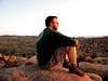
We loaded up and headed for Granite Falls. I've spent very little time in the North Cascades, just because of my early morning tendencies, the family and convenience of I-90. I liked riding along the tree tunnel of the mountain loop highway. We arrived at the Dickerman trail head around 9 am and changed into gear. (Carla kept bragging all day long about her super plastic boots that made her invincible). The temps were "cold", maybe 20s but not too chilly.
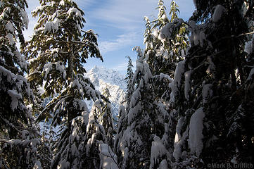
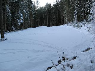
There was just a couple of inches of snow in the trees as we started up the trail. Patches of sunlight through the trees let us know there was a beautiful day out there above the tree line. We stopped to take off layers as the exertion warmed the soul. Around 2.5 miles just where the trail starts to break out of the trees into the upper meadows we stopped and put on our snowshoes.
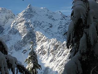
Things were easy going until we broke out of the trees and made deep steps breaking trail through the meadows. Jon (and his Protestant work ethic) broke the most trail, I had to tromp past him once in the meadow to get the lead. As we came to the last 700 feet and made our way through an upper meadow the snow was almost like styrofoam, hard enough we walked on top. The blue sky abounded above us, with some very thin high clouds.
Up and up and up we went till there was nothing but 360 degrees of the uniterrupted peaks as far as the eye could see, all dusted with snow glowing in the sun. It took us 3hr 51 minutes to get to the top. We plopped down in the snow and took a break, admiring the views. Jon fired up his pop can stove and boiled some water for tea while Carla enjoyed her thermos and Matt ran around taking photos. Jon offered me some hot water and as I stood to grab it I tripped on my snowshoes and went hurtling over Matt who was getting out his food and had this concerned look of "uh oh he's gonna squash me" on his face. I landed safely in the snow without hurting anyone, though my camera was underneath me covered in snow. I was able to get most all of the snow and water off though I had some fog issues on the way down.
We sat around for around 50 minutes enjoying the awesome views (is there a better location for views in WA that is as easy to get to?), taking photos and doing peak identification. We stopped for a summit photo in front of Glacier Peak and then started the descent. I love tromping down on fresh snow, though the 2 inch slabby layer on top at times made getting your foot free hard.
The descent was without note other than a few frozen creeks and the fact that it felt like a long slog through the trees. We made it back to the car in just under 2 hours. True to Carla's prediction Matt wore his snowshoes longer than anyone else and was the last to the car, but only by 5 minutes.
The drive home was nice except for that bus and Carla's desire to keep honking Jon's horn at people.
What a fantastic blue sky day in the mountains, thanks for taking me along Matt.
mbg
Few pics
Matt mentioned there were other's joining us from Seattle, but no names. Shortly after Matt and I found each other in the parking lot up drives a Subaru with Jon (who's NWHiker moniker I never did catch) and Dicey/Carla.
We loaded up and headed for Granite Falls. I've spent very little time in the North Cascades, just because of my early morning tendencies, the family and convenience of I-90. I liked riding along the tree tunnel of the mountain loop highway. We arrived at the Dickerman trail head around 9 am and changed into gear. (Carla kept bragging all day long about her super plastic boots that made her invincible). The temps were "cold", maybe 20s but not too chilly.
There was just a couple of inches of snow in the trees as we started up the trail. Patches of sunlight through the trees let us know there was a beautiful day out there above the tree line. We stopped to take off layers as the exertion warmed the soul. Around 2.5 miles just where the trail starts to break out of the trees into the upper meadows we stopped and put on our snowshoes.
Things were easy going until we broke out of the trees and made deep steps breaking trail through the meadows. Jon (and his Protestant work ethic) broke the most trail, I had to tromp past him once in the meadow to get the lead. As we came to the last 700 feet and made our way through an upper meadow the snow was almost like styrofoam, hard enough we walked on top. The blue sky abounded above us, with some very thin high clouds.
Up and up and up we went till there was nothing but 360 degrees of the uniterrupted peaks as far as the eye could see, all dusted with snow glowing in the sun. It took us 3hr 51 minutes to get to the top. We plopped down in the snow and took a break, admiring the views. Jon fired up his pop can stove and boiled some water for tea while Carla enjoyed her thermos and Matt ran around taking photos. Jon offered me some hot water and as I stood to grab it I tripped on my snowshoes and went hurtling over Matt who was getting out his food and had this concerned look of "uh oh he's gonna squash me" on his face. I landed safely in the snow without hurting anyone, though my camera was underneath me covered in snow. I was able to get most all of the snow and water off though I had some fog issues on the way down.
We sat around for around 50 minutes enjoying the awesome views (is there a better location for views in WA that is as easy to get to?), taking photos and doing peak identification. We stopped for a summit photo in front of Glacier Peak and then started the descent. I love tromping down on fresh snow, though the 2 inch slabby layer on top at times made getting your foot free hard.
The descent was without note other than a few frozen creeks and the fact that it felt like a long slog through the trees. We made it back to the car in just under 2 hours. True to Carla's prediction Matt wore his snowshoes longer than anyone else and was the last to the car, but only by 5 minutes.
The drive home was nice except for that bus and Carla's desire to keep honking Jon's horn at people.
What a fantastic blue sky day in the mountains, thanks for taking me along Matt.
mbg
Few pics
 Peak-a-boo 4 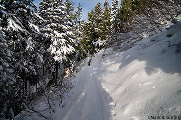 Snow thickens 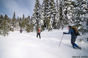 Upper Meadows 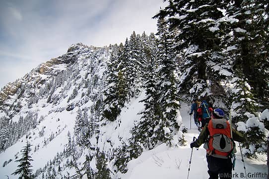 There's the top 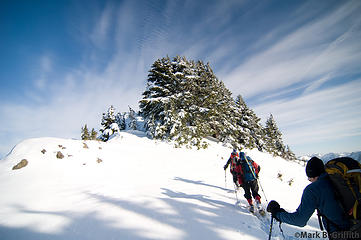 Heading Up 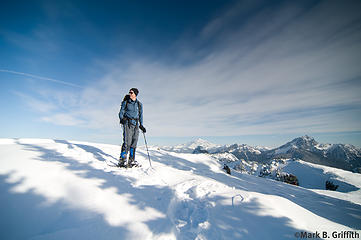 Big Jon Blue 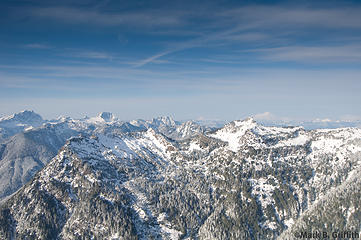 As Far as the Eye Can See 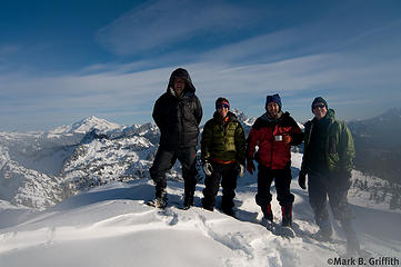 Dickerman Summit Shot 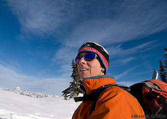 Dicey is not cold 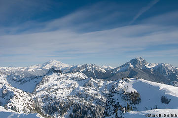 Close Enough
|
| Back to top |
  
|
|
Hikingqueen
Member

Joined: 12 Nov 2007
Posts: 2946 | TRs | Pics
|
Fantastic! I'm so jealous.
|
| Back to top |
|
|
Yet
Member

Joined: 23 Apr 2005
Posts: 2634 | TRs | Pics
Location: Happily Ever After |
|
Yet
Member
|
 Thu Dec 18, 2008 3:48 pm |
|
|
Fun TR!
Glad you didn't squish anyone. 
|
| Back to top |
|
|
wildernessed
viewbagger

Joined: 31 Oct 2004
Posts: 9275 | TRs | Pics
Location: Wenatchee |
 Nice blue skies and pics ! Nice blue skies and pics !
Living in the Anthropocene
Living in the Anthropocene
|
| Back to top |
|
|
Magellan
Brutally Handsome

Joined: 26 Jul 2006
Posts: 13116 | TRs | Pics
Location: Inexorable descent |
|
Magellan
Brutally Handsome
|
Thu Dec 18, 2008 3:58 pm |
|
|
Dickerman is an amazing viewpoint. Thanks for the TR!
|
| Back to top |
|
|
the Zachster
Member

Joined: 17 Jan 2007
Posts: 4776 | TRs | Pics
Location: dog training |
Good for you for getting up there while you still can! It's definitely my favorite for views. Any issues in the waterfall chute or is it too early?
"May I always be the kind of person my dog thinks I am"
"May I always be the kind of person my dog thinks I am"
|
| Back to top |
|
|
Mark Griffith
(Embrace yourself)
Joined: 14 Mar 2005
Posts: 853 | TRs | Pics
Location: Issaquah |
| the Zachster wrote: | | Good for you for getting up there while you still can! It's definitely my favorite for views. Any issues in the waterfall chute or is it too early? |
Not sure what the problems are typically in winter as it was my first time up there. But I can guess it could be a problem with ice build up making it hard to cross or lots of ice above making it dangerous from falling ice. Either way there was not a lot of ice there either on the creek or above. Though Jon did stop and take a lot of photos of the ice.
|
| Back to top |
|
|
Opus
Wannabe

Joined: 04 Mar 2006
Posts: 3700 | TRs | Pics
Location: The big rock candy mountain |
|
Opus
Wannabe
|
Thu Dec 18, 2008 4:33 pm |
|
|
The waterfall tends to get a big snowbridge across it after a few snow falls. It's pretty high angle so there's a falling risk, then later on when the bridge thins there's a chance of falling through into the creek and over the edge.
Awesome photos! Might be the last trip up Dickerman until the spring.
|
| Back to top |
|
|
Roald
Member

Joined: 06 Aug 2007
Posts: 367 | TRs | Pics
Location: Seattle |
|
Roald
Member
|
Thu Dec 18, 2008 6:00 pm |
|
|
|
| Back to top |
|
|
dicey
custom title

Joined: 11 May 2004
Posts: 2870 | TRs | Pics
Location: giving cornices a wider berth |
|
dicey
custom title
|
Thu Dec 18, 2008 9:38 pm |
|
|
Hey thanks to Jon, Matt, and Mark for the awesome company and trail breaking on this trip! I think I ended up breaking trail for about 3 minutes total!  My 3rd trip up Dickerman, and just as sunny as the other 2 times.
This is a great peak for view bagging!
My 3rd trip up Dickerman, and just as sunny as the other 2 times.
This is a great peak for view bagging!
 big four through the trees 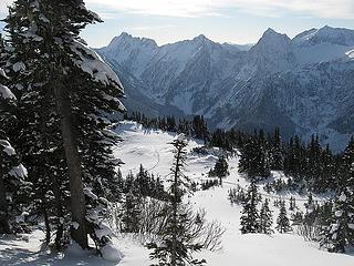 Our snowshoe track 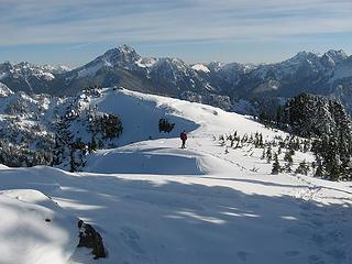 Matt on Dickerman with Sloan behind 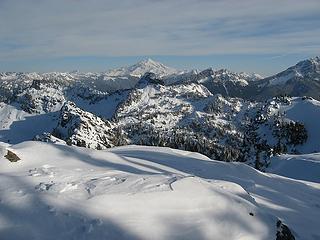 Glacier peak from Dickerman 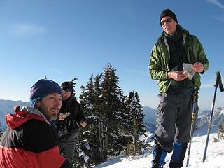 Matt, Mark and Jon on Dickerman
|
| Back to top |
|
|
Mark Griffith
(Embrace yourself)
Joined: 14 Mar 2005
Posts: 853 | TRs | Pics
Location: Issaquah |
| dicey wrote: | | Hey thanks to Jon, Matt, and Mark for the awesome company and trail breaking on this trip! I think I ended up breaking trail for about 3 minutes total! |
Which was the last 40 feet to the top I believe, I think it was your plastic boots that made you invincible to breaking trail
|
| Back to top |
|
|
puzzlr
Mid Fork Rocks

Joined: 13 Feb 2007
Posts: 7220 | TRs | Pics
Location: Stuck in the middle |
|
puzzlr
Mid Fork Rocks
|
Thu Dec 18, 2008 10:49 pm |
|
|
You're snow machines! Good work and great shots. What a fantastic part of the world we live in.
|
| Back to top |
|
|
Ingunn
Hiking Viking
Joined: 01 Feb 2008
Posts: 1751 | TRs | Pics
Location: Redmond |
|
Ingunn
Hiking Viking
|
Thu Dec 18, 2008 10:50 pm |
|
|
Gorgeous, gorgeous, gorgeous - lucky bastards!! 
|
| Back to top |
|
|
Slide Alder Slayer
Member

Joined: 14 Jan 2002
Posts: 1960 | TRs | Pics
|
|
| Back to top |
|
|
Matt
Tea, Earl Grey, Hot

Joined: 30 Jan 2007
Posts: 4307 | TRs | Pics
Location: Shoreline |
|
Matt
Tea, Earl Grey, Hot
|
Fri Dec 19, 2008 1:40 pm Dickerman, 12/16/08
|
|
|
Date: 12/16/08
Destination: Mt. Dickerman 5723 (USGS Bedal)
Party: Matt, Dicey, mbgriffi, Roald
| Yana wrote: | | Bring a down coat or three. Oh, and goggles. And a balaclava or two. Definitely tea. |
Most of us brought the tea, but we didnt get to use most of the other stuff. I was actually sort of disappointed that I didnt get to try out my new face mask and boast about how cold it was. Instead we had to settle for a sunny summit with pretty views.
The Mountain Loop Highway was still open, but Dickermans trailhead parking lot was barricaded. It was odd to see the huge lot empty. There was half a foot of powder snow right down to the 1900-foot trailhead.
 Dickerman Parking Lot 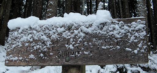 Trailhead Sign 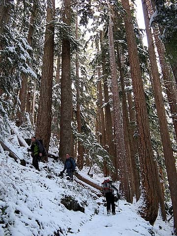 Forest switchback 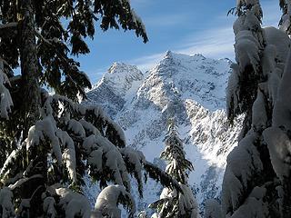 Big Four framed by trees 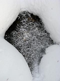 Frost needles on stream ice 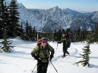 Hiking up (with Hall behind, and Pilchuck distant) 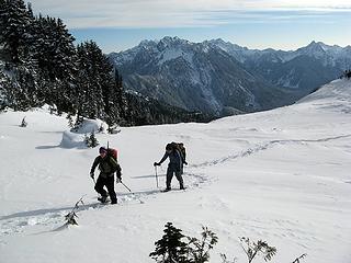 Crusty area & Monte Cristo Peaks 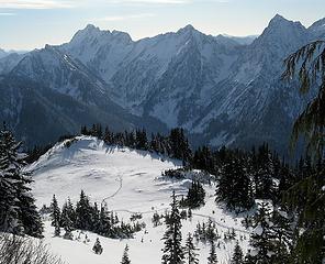 Tracks & Del Campo 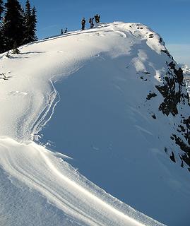 Arriving at Dickerman summit 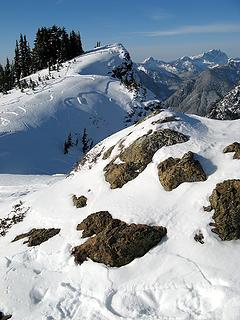 Summit rocks 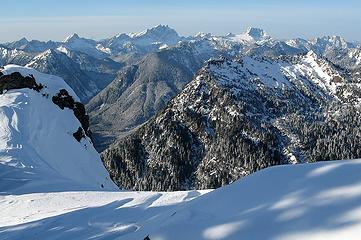 Liberty, Big Bear, Three Fingers, Whitehorse, Jumbo 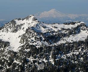 Stillaguamish, Baker 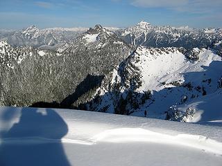 Whitechuck, Forgotten, Pugh 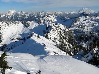 Pugh, Chokwich, Twin Peaks & Glacier 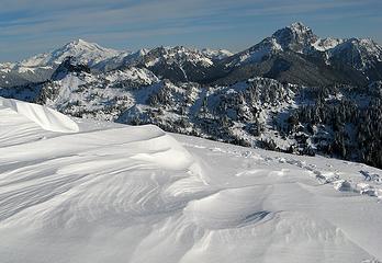 Glacier & Twin Peaks, Bedal, Sloan 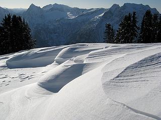 Wind-carved snow with Sperry, Vesper & Big Four 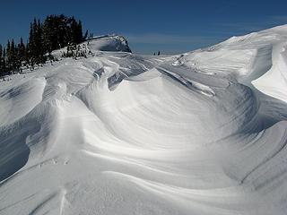 Wind-carved snow & Dickerman 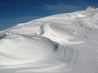 Snow curves and channels 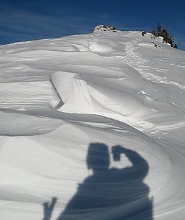 Photographers shadow 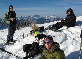 Lunch 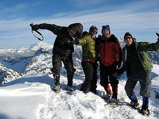 Supposed to act silly, but Im not silly 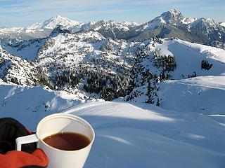 Summit Tea with Glacier & Sloan 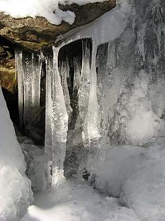 Icicle columns 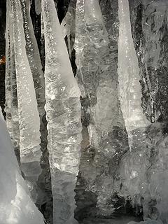 Icicle columns close-up
As beacons mountains burned at evening. J.R.R. Tolkien
As beacons mountains burned at evening. J.R.R. Tolkien
|
| Back to top |
|
|
|
|


 As the guy who left his camera at home, Ive been waiting for Mark or Matt to post some pictures.
  )
A really nice trip. Thanks.
)
A really nice trip. Thanks.


