| Previous :: Next Topic |
| Author |
Message |
Quark
Niece of Alvy Moore


Joined: 15 May 2003
Posts: 14152 | TRs | Pics
|
|
Quark
Niece of Alvy Moore
|
 Tue Feb 17, 2009 12:02 pm |
|
|
We headed out to the Chuckanuts yesterday. JimK introduced me to the Blanchard Mountain trails last summer; though it was too hot a day for me to thoroughly enjoy the place, I saw enough to know I would definitely like it in normal Pacific NW weather.
I had brought an old Signpost magazine along that contains an interview with Eric Ryback (Winter 1974 issue). Jim had fun reading it and perusing the other articles and advertisements - noting Dave Page's first business address - presumably his home - and oogling the bikini clad model for Stephenson gear. Now there's drool all over my dashboard.  We took the Alger exit (#240) off I-5 and turned left, over the freeway. After a mile or so we turned left onto Barrel Springs Road. In a couple of miles we turned right at a clearcut area, onto a road with a hard-to-see sign that read Blanchard Mountain Trails. We passed by the first parking area this is the only parking area with a bathroom, passed by the small trailhead parking area to Lily Lake, and parked at the medium sized parking area just beyond.
We then walked the gated road uphill about a mile to well-signed Alternate Incline Trail (the old incline was a logging incline, a swath used to haul logs. The Alternate Incline Trail is an actual built trail with switchbacks). The trail winds through second growth forest. We were impressed that there are many old trees interspersed here as well. The assumption is that these trees were too young to cut then, and now are quite large.
The trail is a nice grade, and we had no blowdown to negotiate. No massive mudholes, either the trail is in excellent condition, and the forest is very, very pretty. After a couple of miles we hit the old railroad grade. Here are old rusty logging artifacts buried in the moss and fern. We followed this to a junction with the Lizard Lake Trail. Lizard Lake is under snow not too deep, but hiker boots and mountain bikes have beaten it into a fairly slick groove. After hanging out by a huge rock awhile, we went back to the main trail and headed to the junction with Lily Lake. We continued another snowy mile to the Oyster Dome trail, which is in excellent condition no snow on this trail.
On the way back, we passed by the spur trail to Lily Lake and turned right onto the unsigned Lily Lake trail (beyond signed Maxs Shortcut trail) down to the second trailhead we had passed by on the way to our parking spot. This Lily Lake trail is very, very pretty. Large Doug fir trees grow along this trail, and nice creeklets trip down the fern draped slopes. We listened to the wind in the treetops and an owl hooting in the distance.
We met only a few other hiking parties all day and a couple nice guys on mountain bikes. We chatted a bit with them about the
The Lily Lake trail has received recent trail maintenance.
I like to read about the history of a trail when I visit it. Heres a nice little page about the settlement of Blanchard and the mountains logging history.
We took the Alger exit (#240) off I-5 and turned left, over the freeway. After a mile or so we turned left onto Barrel Springs Road. In a couple of miles we turned right at a clearcut area, onto a road with a hard-to-see sign that read Blanchard Mountain Trails. We passed by the first parking area this is the only parking area with a bathroom, passed by the small trailhead parking area to Lily Lake, and parked at the medium sized parking area just beyond.
We then walked the gated road uphill about a mile to well-signed Alternate Incline Trail (the old incline was a logging incline, a swath used to haul logs. The Alternate Incline Trail is an actual built trail with switchbacks). The trail winds through second growth forest. We were impressed that there are many old trees interspersed here as well. The assumption is that these trees were too young to cut then, and now are quite large.
The trail is a nice grade, and we had no blowdown to negotiate. No massive mudholes, either the trail is in excellent condition, and the forest is very, very pretty. After a couple of miles we hit the old railroad grade. Here are old rusty logging artifacts buried in the moss and fern. We followed this to a junction with the Lizard Lake Trail. Lizard Lake is under snow not too deep, but hiker boots and mountain bikes have beaten it into a fairly slick groove. After hanging out by a huge rock awhile, we went back to the main trail and headed to the junction with Lily Lake. We continued another snowy mile to the Oyster Dome trail, which is in excellent condition no snow on this trail.
On the way back, we passed by the spur trail to Lily Lake and turned right onto the unsigned Lily Lake trail (beyond signed Maxs Shortcut trail) down to the second trailhead we had passed by on the way to our parking spot. This Lily Lake trail is very, very pretty. Large Doug fir trees grow along this trail, and nice creeklets trip down the fern draped slopes. We listened to the wind in the treetops and an owl hooting in the distance.
We met only a few other hiking parties all day and a couple nice guys on mountain bikes. We chatted a bit with them about the
The Lily Lake trail has received recent trail maintenance.
I like to read about the history of a trail when I visit it. Heres a nice little page about the settlement of Blanchard and the mountains logging history.
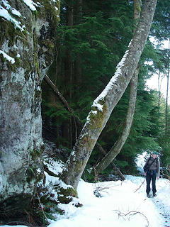 Jim at big rock 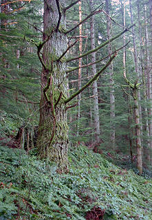 Branchy doug fir 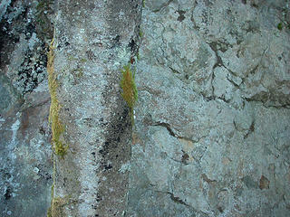 Alder in front of rock - lookalikes 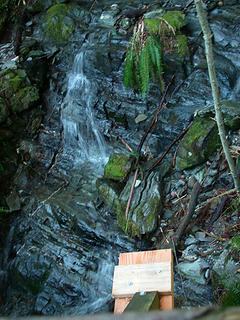 Best view of falls from Stupid Behemoth Bridge 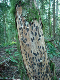 Spotted tree 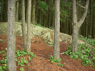 Colorful green rock at Oyster Dome viewpoint 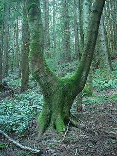 Hmmmm 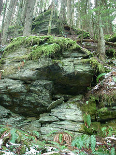 trees and rock 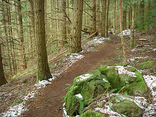 branchy doug fir and trail 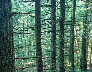 typical of a forest whose canopy is closing in - lower branches are dying and will soon fall, leaving the tall, branchless trunks we see in older forests whose canopy has already closed. Blanchard Mtn was logged about a hundred years ago and now the forest is transitioning to another stage of life. 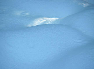 Snow hills and a patch of sunlight 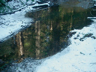 Reflection of trees 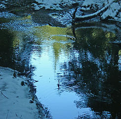 Reflection in pond with drop circle 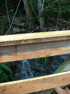 This is the view that a person of average height can expect. 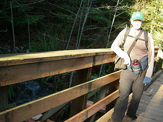 Stupid Behemoth Bridge. 6'4" hiker for scale 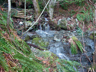 What hikers are missing. To see this, you have to exit the bridge. Not difficult to do, but still.... 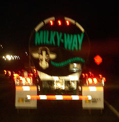 Drinkamugamilkameal
"...Other than that, the post was more or less accurate."
Bernardo, NW Hikers' Bureau Chief of Reporting
"...Other than that, the post was more or less accurate."
Bernardo, NW Hikers' Bureau Chief of Reporting
|
| Back to top |
  
|
|
Bloated Chipmunk
Cock Rock Searcher

Joined: 29 Jan 2007
Posts: 2993 | TRs | Pics
Location: Margaritaville |
Home is where the hiking is.
"Peaks that have come and gone four times should halt a man in his steps." -- William O. Douglas
A balanced diet is a margarita in each hand.
|
| Back to top |
|
|
Quark
Niece of Alvy Moore
Joined: 15 May 2003
Posts: 14152 | TRs | Pics
|
|
Quark
Niece of Alvy Moore
|
Tue Feb 17, 2009 12:20 pm |
|
|
I know! I think I'll apply for a job there, just to be around those trucks. I might drive everyone nuts though, hollering out, "drinkamugamilkameal!" all day. It's sorta like Holden Caulfield's grandfather who had a habit of hollering out the street names while riding the bus.*
*ha! who would have thought that a drinkamugamilkameal truck would help me in my ongoing project of eventually having quoted or paraphrasing every line in JD Salinger's "Catcher in the Rye."
"...Other than that, the post was more or less accurate."
Bernardo, NW Hikers' Bureau Chief of Reporting
"...Other than that, the post was more or less accurate."
Bernardo, NW Hikers' Bureau Chief of Reporting
|
| Back to top |
|
|
Elvis
Shuffl'n
Joined: 09 Jun 2004
Posts: 1804 | TRs | Pics
Location: del Boca Vista |
|
Elvis
Shuffl'n
|
Wed Feb 18, 2009 12:31 am |
|
|
| Quark wrote: | | I know! I think I'll apply for a job there, just to be around those trucks. |
 I worked for them for a while... and I'll put in a good word for ya (heck, lots of good words for ya) ... but you'll prolly haffta move to Lynden.
Nice write up of Blanchard by the way.
I worked for them for a while... and I'll put in a good word for ya (heck, lots of good words for ya) ... but you'll prolly haffta move to Lynden.
Nice write up of Blanchard by the way.  ~E
~E
"Ill habits gather unseen degrees, as brooks make rivers, rivers run to seas." ~John Dryden
My Trip List
"Ill habits gather unseen degrees, as brooks make rivers, rivers run to seas." ~John Dryden
My Trip List
|
| Back to top |
|
|
Highwalker's Daughter
Member
Joined: 12 Aug 2006
Posts: 1575 | TRs | Pics
Location: Bothell, WA |
Thank you for the write up and the pictures as I was thinking of doing this one soon. I've just been snowshoeing for weeks and am ready for something different. It sounds like it will be a nice change.
|
| Back to top |
|
|
JimK
Member

Joined: 07 Feb 2002
Posts: 5606 | TRs | Pics
Location: Ballard |
|
JimK
Member
|
Thu Feb 19, 2009 3:07 pm |
|
|
My turn to chime in.
Kim and I headed north for a Presidents Day hike. I first hiked to Oyster Dome in 2005(map at link). Last year I returned with Suzanne for a trip completely on snow. Later in the year Kim and I visited but did not make it to the viewpoint. This would be a good time for a return visit. On each of my previous visits I started on the east side of Blanchard Hill rather than off of Chuckanut Drive. This allows for more miles, many fewer people, lakes, and a variety of loops. We parked at the upper trailhead just a few miles from exit 240 off I-5. There were two cars already there. It was cold and cloudy though it was supposed to clear up and warm up.
 Ice Patterns On My Car 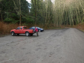 Upper Trailhead 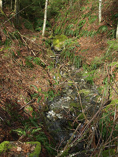 Creek 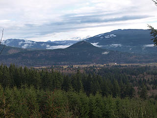 View West 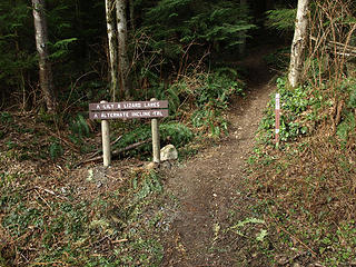 Start Of Alt Incline Trail 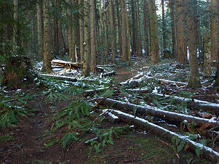 First Snow 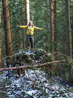 Kim Is Stumped 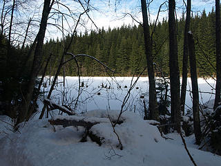 Lizard Lake 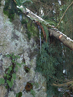 Icicle 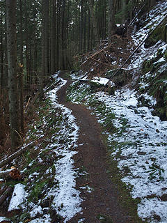 PNT 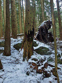 Old Snag 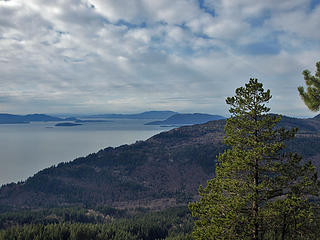 Oyster Dome View NW 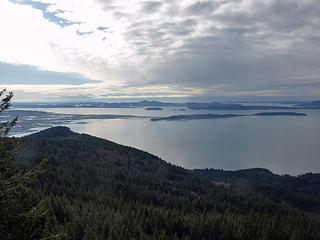 Oyster Dome View SW 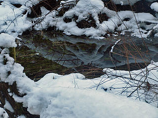 Snowy Reflection 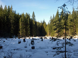 Dry Beaver Pond 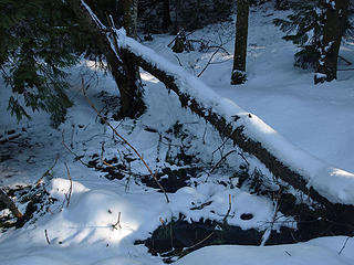 Sun On Snow 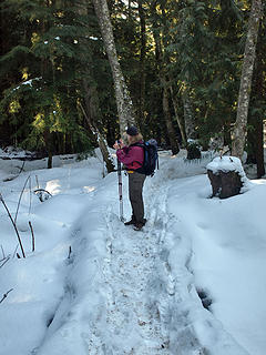 Shooting The Shooter 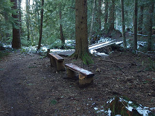 Benches Near Creek 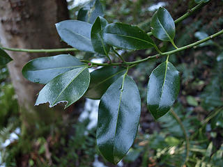 Mystery Leaves 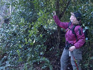 Vine Like Branch
|
| Back to top |
|
|
Quark
Niece of Alvy Moore
Joined: 15 May 2003
Posts: 14152 | TRs | Pics
|
|
Quark
Niece of Alvy Moore
|
Thu Feb 19, 2009 4:02 pm |
|
|
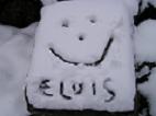
God I'm fat. And I have no chin!  The top of your car is gorgeous!
Jim, did you get a side shot of that Stupid Behemoth Bridge that you can post?
The top of your car is gorgeous!
Jim, did you get a side shot of that Stupid Behemoth Bridge that you can post?
"...Other than that, the post was more or less accurate."
Bernardo, NW Hikers' Bureau Chief of Reporting
"...Other than that, the post was more or less accurate."
Bernardo, NW Hikers' Bureau Chief of Reporting
|
| Back to top |
|
|
|
|
You cannot post new topics in this forum
You cannot reply to topics in this forum
You cannot edit your posts in this forum
You cannot delete your posts in this forum
You cannot vote in polls in this forum
|
Disclosure: As an Amazon Associate NWHikers.net earns from qualifying purchases when you use our link(s). |


 It's all good though, it makes me think of Milky Way chocolate bars.
  Nice pics BTW.


