| Previous :: Next Topic |
| Author |
Message |
rogue_hiker
Member

Joined: 15 Jan 2004
Posts: 28 | TRs | Pics
|
Thought I'd post this trip report even though the hike occurred over three months ago, just in case anyone is interested in planning a hike along the Rogue River Trail...
Back in Oregon to visit family, I decided to plan a 3-4 day hike. Given that it was hunting season, I finally decided on Crater Lake NP, but was driven out on the second day by a blizzard. Plan B was the Rogue River Trail, but since it is a linear trail and I didn't have time to set up a shuttle, I decided to hike from Grave Creek to Quail Creek and back, for about 38+ miles over four days. I started out on Monday, October 20th and hiked in about 13 miles to Meadow Creek, a nice camping area with an outhouse (nocturnal trips should be done with a flashlight, given that the privy is surrounded by poison oak). Lots of poison oak right alongside the trail and copious quantities of terrific tasting water from the many creeks crossed by the trail. These little glens are heavily shaded and at least 10 degrees cooler than the hillsides, which makes them perfect places for a break, lunch or for camping. Perhaps due to the steepness of the trail, I ran into an incredible quantity of bear scat of varying freshness throughout the first day's hike. Given that commercial rafting season had ended on the 15th, it was hunting season, and the lateness of the year, I saw nary a soul during the day, either along the trail or on the river. However, that evening at camp I saw four hikers with daypacks come up the trail and then take a side trail up the side of the canyon (I think they were parked up on top of the canyon on a skid road and had done a loop down to the river and back up). The second day I hiked to Quail Creek but then decided to camp back along the trail after I ran into fresh prints from a sow and cub on a sandy beach alongside the river. I hiked back to a beautiful camp at Ditch Creek (no privy). Saw several rafters and drift boats with fishers during the day, but no other hikers. And somehow I missed the turn-off to Zane Grey's cabin during the hike back, even though I had seen the turn-off on the way in that morning. I didn't turn back once I realized my mistake, since one of my boots had blown out its side and I was fast developing a nice blood blister on my foot. The next day I hiked to Russian Creek (no privy), an absolutely gorgeous camping spot. The entire area was covered in beautifully colored leaves, which gave it that peculiar, earthy perfume of fall. That night a few raindrops fell, the only precipitation of the whole four day trip. Temperatures ranged from the mid to high 70s during the day to the high 50s at night, which made my 30F bag a bit too warm for the hike (but given the good chance of storms that time of year, I would continue to carry the warmer bag and other cold/rainy weather gear). A morning's hike the next day brought me back to the Grave Creek trailhead. Saw quite a few rafters and fishing boats the last two days, as the weekend approached. Also ran into a hunting party of three young high school age boys and a middle age man. They were pushing a long wheelbarrow with some of their gear, which I assume they would use to bring their deer back out. While the BLM folks told me there would be few hunters given restrictions on discharging firearms along the trail and also given the remoteness and difficulty of access to the trail, I draped a blaze orange plastic vest over the top of my (blue) backpack and also wore a red cap. Final impressions: Great late fall hike, if you hike on the weekdays after commercial rafting season is over, since you'll encounter few hunters or hikers and have little or no competition for campsites (I was all alone at all three of my campsites). Plenty of poison oak alongside the trail, but not so much that it can't easily be avoided. Plentiful, tasty water and many, beautiful campsites. Bridges over all the creeks. I did not run into even one mosquito, tick or yellow jacket (must have been a cold snap sometime earlier), which in my book is a huge, huge plus. I didn't have any luck fishing, unfortunately. Saw two bald eagles and several wild Canada geese, but no deer or bear (it was hunting season, after all, and I did hear the occasional shot from far over the top of the canyon).
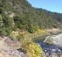
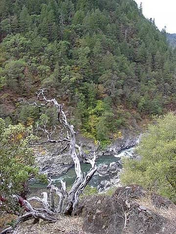 2 - Wild and Scenic Rogue 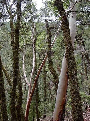 6 - Madrone trees 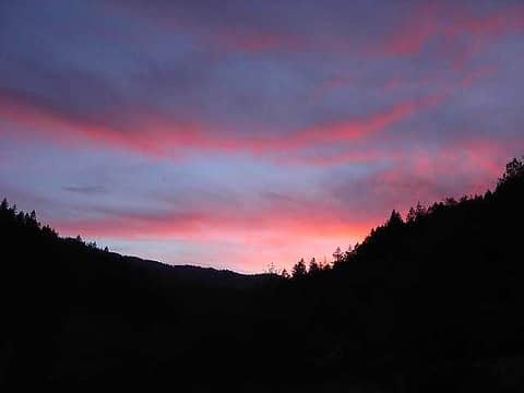 10 - Sunset from camp at Ditch Creek 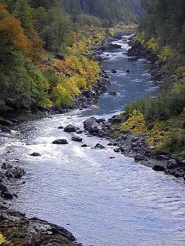 11 - View of Rogue from Ditch Creek 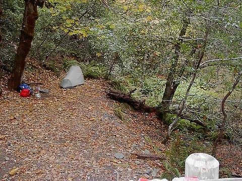 12 - Camp at Russian Creek
|
| Back to top |
  
|
|
pianodirt
Member

Joined: 22 Oct 2003
Posts: 206 | TRs | Pics
Location: glenoid fossa |
Thanks for the report and pics, rogue. I have not hiked along the Rogue, but I did do a 5 day raft trip about 12 years ago. It is one of the most beautiful trips I have done anywhere. The scenery amazing, the water amazing, the wildlife...amazing. I hope this area remains relatively unspoiled for years to come.
-pianodirt
|
| Back to top |
|
|
MooseAndSquirrel
Member

Joined: 10 Nov 2002
Posts: 2036 | TRs | Pics
|
Ditto on the report. I've heard the rafting is supposed to be great on it. Wasn't there a recent movie filmed on it? That one with Meryl Streep & Kevin Bacon- "River Wild"?
|
| Back to top |
|
|
rogue_hiker
Member
Joined: 15 Jan 2004
Posts: 28 | TRs | Pics
|
Thanks for your nice comments on the trip report. Hopefully, with its designation as a Wild and Scenic River, the Rogue will be remain a treasure that our children and grandchildren will be able to enjoy as we have, be it through hiking or rafting. I've heard some of the campsites can get a bit crowded during the height of the commercial rafting season, even though access is tightly controlled through a permit system. But I suspect this would mostly be during June-August, when it would be too hot in the canyon for enjoyable hiking. Temperatures during that time of the year routinely reach 100+ in nearby Grants Pass.
And, yes, I've read that several rapids in the canyon were filmed and used in "River Wild". I got up close to several rapids while I was fishing and having done a bit of canoeing many years back I was a bit awestruck by the wildness and power of those rapids. I think I may have to go back and do a rafting trip with some experienced company!
|
| Back to top |
|
|
MooseAndSquirrel
Member
Joined: 10 Nov 2002
Posts: 2036 | TRs | Pics
|
Do you know anything about hiking/recreation along the Umpqua River? A few years ago I drove Hwy 38 from the coast to Cottage Grove near !-5 in Oct. and the drive alongside the river was really nice- very scenic in fall color. Thanks.
|
| Back to top |
|
|
BarePaw
Barefoot Hiker

Joined: 03 Jun 2003
Posts: 425 | TRs | Pics
Location: Here |
|
BarePaw
Barefoot Hiker
|
 Mon Feb 09, 2004 2:14 pm |
|
|
Nice pics. I especially like the view from Ditch Creek. Is that the river that the brewing company is named after?
|
| Back to top |
|
|
rogue_hiker
Member
Joined: 15 Jan 2004
Posts: 28 | TRs | Pics
|
MooseAndSquirrel: No, I haven't hiked along the Umpqua yet, though I did drive along it many years ago and agree with you that it is a gorgeous river. (Now you've gone and done it...I'm going to have to start researching a hike along the Umpqua!)
Barepaw: If you're referring to Rogue River Brewing Co., yup, the name comes from the river (the Rogue dominates that entire area, from its origins on the flanks of Crater Lake to its end at the coast at Gold Beach).
|
| Back to top |
|
|
MooseAndSquirrel
Member
Joined: 10 Nov 2002
Posts: 2036 | TRs | Pics
|
| rogue2 wrote: | | MooseAndSquirrel: No, I haven't hiked along the Umpqua yet, though I did drive along it many years ago and agree with you that it is a gorgeous river. (Now you've gone and done it...I'm going to have to start researching a hike along the Umpqua!) |
I could have (and will) research it as well, just thought maybe you'd have some insider info as it were. I was really impressed with that drive- I had decided at the last minute to pop over to I-5 to head back to Seattle rather than continuing on the slower albeit beautiful coast highway. Glad I did! Unfortunately having a major road alongside the river would put a damper on any kind of wilderness experience if a trail was nearby! But a lovely drive indeed. M&S
|
| Back to top |
|
|
rogue_hiker
Member
Joined: 15 Jan 2004
Posts: 28 | TRs | Pics
|
M&S: I checked out the Umpqua with my TOPO software, and it looks like it is followed by a road (either gravel or paved) from its source all the way to the coast. Too bad...but there are still a couple of other rivers down in that area that have large roadless stretches. The Illinois is one I looked at last year, but discarded since I was going to be hiking during hunting season and the trail is used by hunters and packers. But through September it should receive relatively light use. It is 36 miles or so. Then there's also some trails along the Chetco River, which is also pretty isolated. Both are in the Kalmiopsis Wilderness, which was hit hard in some areas by the Florence/Biscuit fire of a couple of years ago. But from what I've read the fire hopped around quite a bit, leaving lots of patches untouched. Two winters later most of the ash should have washed away and many of the snags have probably already fallen (though I would probably want to avoid pitching my tent under one anyway). A ranger I contacted last year told me that a bridge over one creek had burned up, but at low water that shouldn't be a problem (and they may even have fixed it by now). Hmmm, could be interesting...
|
| Back to top |
|
|
|
|
You cannot post new topics in this forum
You cannot reply to topics in this forum
You cannot edit your posts in this forum
You cannot delete your posts in this forum
You cannot vote in polls in this forum
|
Disclosure: As an Amazon Associate NWHikers.net earns from qualifying purchases when you use our link(s). |


