| Previous :: Next Topic |
| Author |
Message |
GeoTom
Member

Joined: 19 May 2005
Posts: 3215 | TRs | Pics
Location: Earth |
|
GeoTom
Member
|
 Sun Jun 21, 2009 10:37 pm |
|
|
Trip overview:
Crew: Schmidt Alti-Babe, yukon222, GeoTom, Soapy
Maps: Green Trails #209s The Enchantments and a couple TOPO! creations
Access: Highway 2 > Icicle Road > Eightmile Road
Trails/Route: Lake Stuart #1599 > Colchuck Lake #1599.1 > Aasgard Pass
Mileage: ~15 total (Based on guidebook info, GPS might differ)
Elevation Gain: ~6,200 with the ups and downs. (Based on guidebook info, altimeter log might differ)
Summits: Dragontail Peak (8,840), SE Dragontail Peak (8,760)
Trip Details:
I had originally hoped to head up into this area last weekend before permits were required and ascend Dragontail and possibly one or more other peaks in the area. However, the weather forecast called for thunderstorms so we cancelled the trip. Wildernessed managed to get in and out before the weather moved in, and provided some good info for this weekend.
All week I sat at my desk anxiously waiting for the latest forecast on the NWS website. The pinpoint forecast was clicked many times in various locations in hopes that the forecast would improve. By Thursday night it looked acceptable. Then Friday morning I woke up to discover that it had deteriorated.  During the day Friday it improved slightly, then stabilized. A flurry of emails took a drive on the information superhighway and eventually we all agreed to just go for it, with a backup plan or two in place should the actual weather make a turn for the worse.
A few minutes past their expected pickup time of 5:23 pm, yukon and the Alti-Babe arrived to pick me up. The drive over Stevens Pass went smoothly, and we arrived in Leavenworth with plenty of time to spare for a nice dinner and finding a spot to set up the tents and get some needed sleep. During the day Friday it improved slightly, then stabilized. A flurry of emails took a drive on the information superhighway and eventually we all agreed to just go for it, with a backup plan or two in place should the actual weather make a turn for the worse.
A few minutes past their expected pickup time of 5:23 pm, yukon and the Alti-Babe arrived to pick me up. The drive over Stevens Pass went smoothly, and we arrived in Leavenworth with plenty of time to spare for a nice dinner and finding a spot to set up the tents and get some needed sleep. 
 It looks like a dragon...right?  We packed up and drove the short distance to the trailhead. I was ready to go before Alti-Babe and yukon (about the only time I was ahead of them all day), so I went to the trailhead register and filled out the day use permit. I briefly chatted with one guy who was headed up to Colchuck Balanced Rock. I asked him nicely not to trundle it into Colchuck Lake.
We had originally planned to ride some quads up the trail to the Stuart Lake/Colchuck Lake junction, but the trailhead bulletin board said that they weren't allowed, so we started out on foot. The trail was entirely snow free to Colchuck Lake, where we took a nice break in the sun and had a snack. The way around the south end of Colchuck Lake to the base of Aasgard Pass went smoothly, with only a couple minor snow patches. It was at this point that the first clouds appeared above the Colchuck Col. The skies were still mostly clear, so we continued our ascent. We packed up and drove the short distance to the trailhead. I was ready to go before Alti-Babe and yukon (about the only time I was ahead of them all day), so I went to the trailhead register and filled out the day use permit. I briefly chatted with one guy who was headed up to Colchuck Balanced Rock. I asked him nicely not to trundle it into Colchuck Lake.
We had originally planned to ride some quads up the trail to the Stuart Lake/Colchuck Lake junction, but the trailhead bulletin board said that they weren't allowed, so we started out on foot. The trail was entirely snow free to Colchuck Lake, where we took a nice break in the sun and had a snack. The way around the south end of Colchuck Lake to the base of Aasgard Pass went smoothly, with only a couple minor snow patches. It was at this point that the first clouds appeared above the Colchuck Col. The skies were still mostly clear, so we continued our ascent.
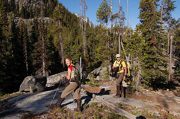 Enjoying the morning sun 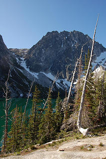 Dragontail over Colchuck Lake 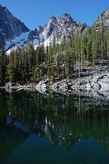 Colchuck Peak reflected in 'Warmchuck' Pond 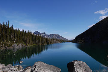 Colchuck Lake and Cashmere Mountain 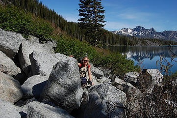 Alti-Babe emerges from the rocks 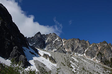 Clouds over Colchuck 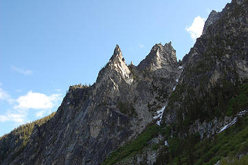 Jabberwocky Tower 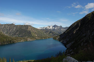 Cashmere Mountain and Colchuck Lake 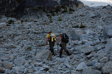 Yellow and Red Gummi Bears lead the way 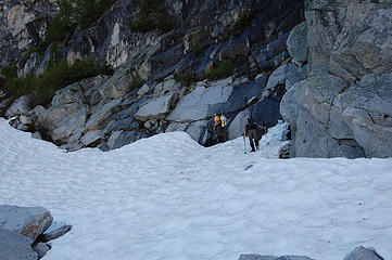 Hard snow patch 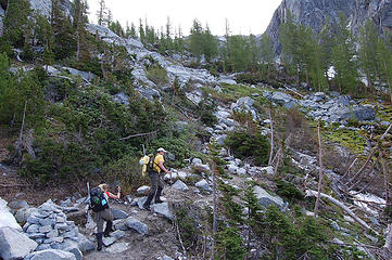 Back on the 'trail' to Aasgard Pass 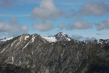 Eightmile Mountain and Axis 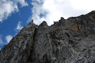 Rock spires 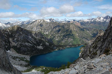 Colchuck Lake and peaks 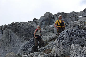 yukon scouts our route while Alti-Babe plans future hikes 
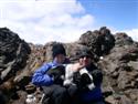
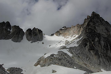 The route up Snow Creek Glacier 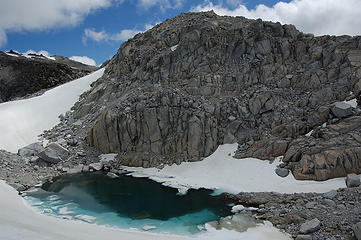 Mist Pond and Mist rock pile 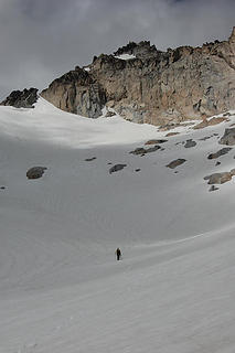 Wait for me 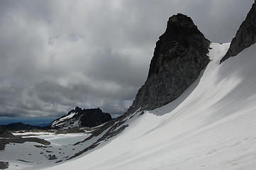 McClellan Peak and Witches Tower 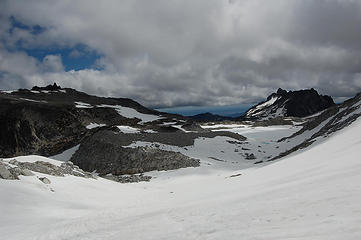 Enchantment Lakes basin 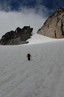 Moody sky above 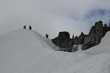 Climbers of various species 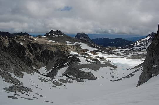 The Enchantments 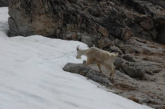 The goat heads for the snow 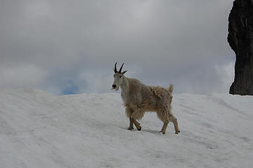 How is my scruffy pose?  We enjoyed the views on the summit and took a nice relaxing break chatting with each other and the Mounties group that arrived shortly after us. We enjoyed the views on the summit and took a nice relaxing break chatting with each other and the Mounties group that arrived shortly after us.
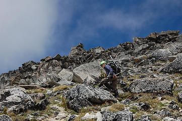 Alti-Babe ascends with poles ready to fend off pika attacks 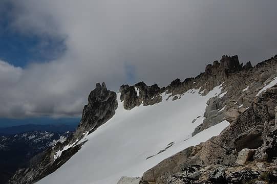 A look to Pandora's Box 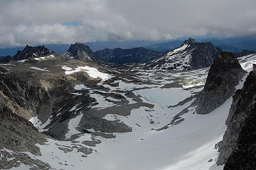 Enchantment Lakes 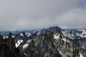 Stuart hiding, but Colchuck, Argonaut and a bit of Sherpa showing 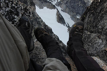 Shoes 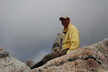 yukon in yellow 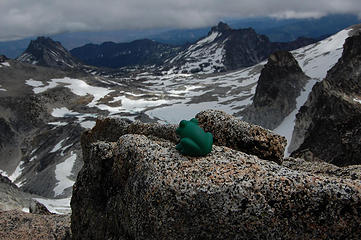 Soapy on Dragontail 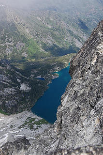 A slice of Colchuck Lake 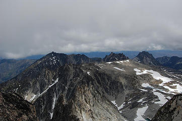 Cannon Mountain, Enchantment Peak, Prusik Peak and Mt. Temple 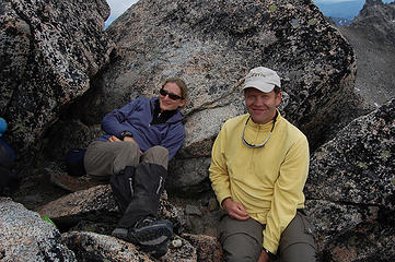 All smiles on Dragontail 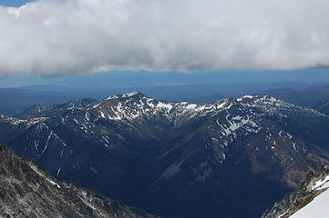 The Teanaway 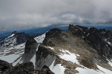 East Dragontail Plateau  While I am too tall for the club, I was still unable to reach the hold without a little assistance from above. I was worried about yukon's ability to hoist me as I am significantly more, um, stout, than the Alti-Babe, but he is stronger than he looks and soon enough we were all on the top, peering down at Witches Tower below. While I am too tall for the club, I was still unable to reach the hold without a little assistance from above. I was worried about yukon's ability to hoist me as I am significantly more, um, stout, than the Alti-Babe, but he is stronger than he looks and soon enough we were all on the top, peering down at Witches Tower below.
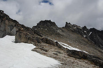 Heading toward SE Dragontail 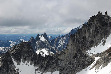 Argonaut Peak in the distance 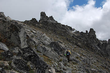 Almost to SE Dragontail 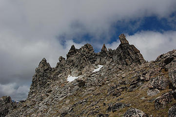 Spires along the East Dragontail Plateau 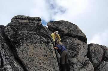 Lending a helping hand 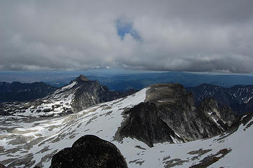 McClellan Peak and Little Annapurna 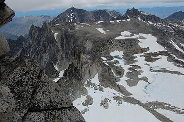 Looking down on Witches Tower 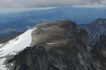 Little Annapurna  Tahoma makes a fleeting appearance 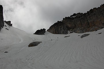 Glissading about to start 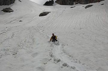 yuk-isade 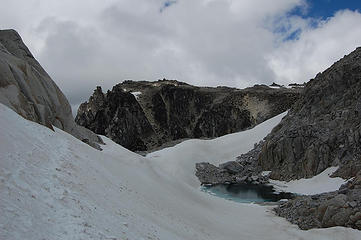 Heading back to Aasgard Pass 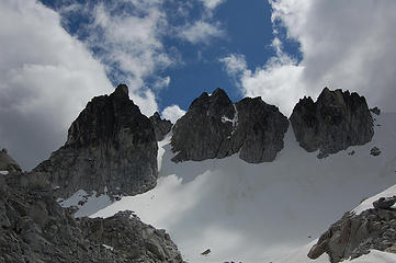 Witches Tower and Dragontail spires again 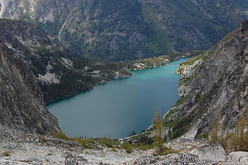 Colchuck Lake 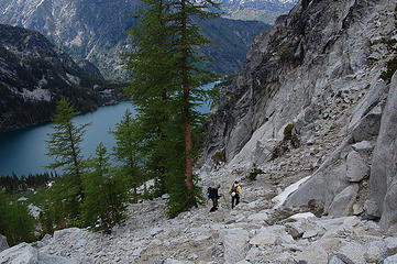 Descending from Aasgard Pass 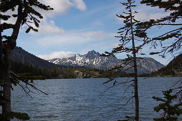 Cashmere Mountain above Colchuck Lake 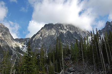 Lingering clouds over Dragontail 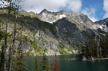 Goodbye Colchuck Lake 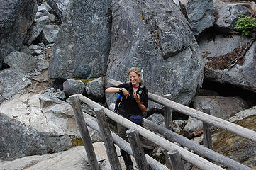 Representin' the NWH posse on the Colchuck set
|
| Back to top |
  
|
|
Magellan
Brutally Handsome

Joined: 26 Jul 2006
Posts: 13116 | TRs | Pics
Location: Inexorable descent |
|
Magellan
Brutally Handsome
|
Sun Jun 21, 2009 10:43 pm |
|
|
Nice work you guys. I remember 'Magellan' being dismissed on a trail when they found out I was hiking with an NWH legend, 'EastKing'.
|
| Back to top |
|
|
Sennin
Member

Joined: 31 Jul 2008
Posts: 691 | TRs | Pics
Location: West Seattle |
|
Sennin
Member
|
Mon Jun 22, 2009 8:21 am |
|
|
|
| Back to top |
|
|
wildernessed
viewbagger

Joined: 31 Oct 2004
Posts: 9275 | TRs | Pics
Location: Wenatchee |
Strong work, and good shots from East Dragontail, especially of the route to Witches Tower.
Living in the Anthropocene
Living in the Anthropocene
|
| Back to top |
|
|
wamtngal
Member

Joined: 13 Jun 2004
Posts: 2382 | TRs | Pics
Location: somewhere |
|
wamtngal
Member
|
Mon Jun 22, 2009 9:27 am |
|
|
Opinions expressed here are my own.
|
| Back to top |
|
|
silence
Member

Joined: 25 Apr 2005
Posts: 4420 | TRs | Pics
|
|
silence
Member
|
Mon Jun 22, 2009 10:34 am |
|
|
really great tr and pix ... way to get er done
PHOTOS
FILMS
Keep a good head and always carry a light bulb. Bob Dylan
PHOTOS
FILMS
Keep a good head and always carry a light bulb. Bob Dylan
|
| Back to top |
|
|
yukon222
Member

Joined: 12 Mar 2007
Posts: 1893 | TRs | Pics
|
|
yukon222
Member
|
Mon Jun 22, 2009 11:34 am |
|
|
Thanks for writing up the TR, Tom! It was a very fun trip - worthwhile to break up the driving a bit by driving over to the Icicle Friday night and getting an early start when the weather was crystal clear.
I'll post my set of pictures tonight. Similar but different than yours.  
|
| Back to top |
|
|
DIYSteve
seeking hygge

Joined: 06 Mar 2007
Posts: 12655 | TRs | Pics
Location: here now |
|
DIYSteve
seeking hygge
|
Mon Jun 22, 2009 11:39 am |
|
|
Great pics, GeoTom. Lauds for heading east to avoid the June on-shore crap weather. DT has seen lots of NWHikers in the past few weeks.
|
| Back to top |
|
|
seattlehikertoo
Member

Joined: 26 Jun 2008
Posts: 582 | TRs | Pics
Location: Finding an alternative to Mailbox Pk |
Another nice trip. Very iffy weather will continue for the next 5 to 10 days, but better the further south and east you go. Expecting it to warm up a bit later this week. Where are the Alti-Whippets?
|
| Back to top |
|
|
GeoTom
Member
Joined: 19 May 2005
Posts: 3215 | TRs | Pics
Location: Earth |
|
GeoTom
Member
|
Mon Jun 22, 2009 12:00 pm |
|
|
Thanks for the comments, and looking forward to your photos yukon. You did take a couple, right?  seattlehikertoo-
Dogs are not allowed in these areas. The Alti-Whippets and Jasper had to stay home for this one. Soapy may not have technically been allowed either, but he lives by his own set of rules.
seattlehikertoo-
Dogs are not allowed in these areas. The Alti-Whippets and Jasper had to stay home for this one. Soapy may not have technically been allowed either, but he lives by his own set of rules.
|
| Back to top |
|
|
seattlehikertoo
Member
Joined: 26 Jun 2008
Posts: 582 | TRs | Pics
Location: Finding an alternative to Mailbox Pk |
Oh sh*t, that's right. Slipped my mind because I am so used to seeing them.
|
| Back to top |
|
|
gone
Member

Joined: 08 Feb 2008
Posts: 1051 | TRs | Pics
|
|
gone
Member
|
Mon Jun 22, 2009 1:36 pm |
|
|
Great report, GeoTom, wonderful pictures and story telling!
Looks to have been a great trip, lot of work. I'm so glad the weather held firm for you all - those blue skies are fantastic!
|
| Back to top |
|
|
Ingunn
Hiking Viking
Joined: 01 Feb 2008
Posts: 1751 | TRs | Pics
Location: Redmond |
|
Ingunn
Hiking Viking
|
Mon Jun 22, 2009 1:57 pm |
|
|
Huzzah, I'm glad you didn't get snowed on! Looking forward to the rest of the photos.
Too bad Jasper isn't allowed as he really needs to get some tail. Well, at least a tail.
|
| Back to top |
|
|
raising3hikers
Member
Joined: 21 Sep 2007
Posts: 2344 | TRs | Pics
Location: Edmonds, Wa |
Very nice TR and pics Good job on also getting to the top of the SE peak, it looked like a tough climb. Also, it was very nice to meet the 3 of you at no better place than the summit of a nice, scenic peak.
|
| Back to top |
|
|
yukon222
Member
Joined: 12 Mar 2007
Posts: 1893 | TRs | Pics
|
|
yukon222
Member
|
Mon Jun 22, 2009 10:23 pm |
|
|
Here are some of my pics from Saturday's very enjoyable climb. I never get tired of popping over the ridge and seeing Colchuck Lake with Dragontail soaring above it. Spectacular setting.
 DSD_1940 GeoTom pauses 1/3 of way up Aasgard Pass DSD_1952 GeoTom climbs sweeping lines of snow to Dragontail Col 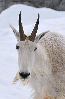 DSD_1979 "Hmm, should I charge or ...." 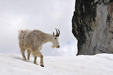 DSD_1984 Goat doing a bit of two-steppin... DSD_1998 GeoTom cautiously peers over 3,000' Dragontail drop DSD_2135 GeoTom savors Mountaineer Creek
|
| Back to top |
|
|
|
|
You cannot post new topics in this forum
You cannot reply to topics in this forum
You cannot edit your posts in this forum
You cannot delete your posts in this forum
You cannot vote in polls in this forum
|
Disclosure: As an Amazon Associate NWHikers.net earns from qualifying purchases when you use our link(s). |


 Nice write-up GT, as always, it made me laugh. I especially liked the fact that out of all three -- errr four -- of you, Soapy was the one who got recognized. Of course this must be due to his reckless behavior. I bet he was hanging off the side of some rock with hundreds of feet of air below him when he was spotted by raising2hikers.
And good summits y'all!
Nice write-up GT, as always, it made me laugh. I especially liked the fact that out of all three -- errr four -- of you, Soapy was the one who got recognized. Of course this must be due to his reckless behavior. I bet he was hanging off the side of some rock with hundreds of feet of air below him when he was spotted by raising2hikers.
And good summits y'all! 


