| Previous :: Next Topic |
| Author |
Message |
Soccer_Dad
Member

Joined: 28 Mar 2006
Posts: 180 | TRs | Pics
Location: Montevideo, Uruguay (really) |
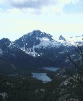
Let's call this a preliminary report on a pretty darn interesting area of northern Idaho. The high country of the Idaho Selkirks is probably just about unfrozen now, but I had time for only a short hike, so my wife (she hikes rivers, my daughter prefers ridges) and I decided to explore the cascades on Lion Creek, known as the Slippery Rocks. They were a total accidental discovery by me - I was looking into hikes in the Lookout Peak area, and came across a few intriguing photos on Google Earth.
The area didn't disappoint, although I would caution that you might find the area to be too popular for you. We went in on a Friday, and there were two other groups there - one with about 7 parents and 12 kids, and another family of 4. I imagine that, on a really hot weekend, you might find the area overrun by locals getting cool in the streams.
[I apologize for the picture quality - I forgot my camera and ended up getting these with my cell phone]
Anyway, it's a short 4/10 mile walk to the first cascade. It's a nice series of pools and short cascades and falls.
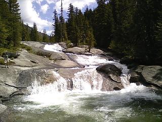 Lower part of lower Lion Creek Cascades 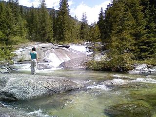 Upper part of Lower Lion Creek Cascades 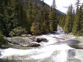 Looking down from the middle of Lower Lion Creek cascades 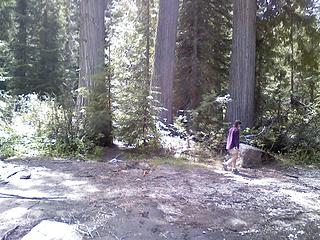 Cedar Grove near the confluence of Lion and Kent Creeks 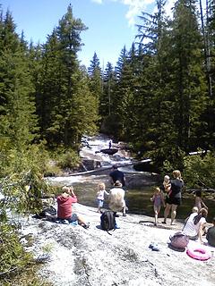 Upper Lion Creek Cascades 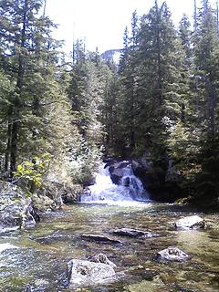 Small Waterfall on Lion Creek 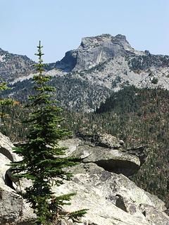 West Lions Head from Lookout Mountain (fall 2008)
|
| Back to top |
  
|
|
trailjunky
Backcountry Bumpkin'

Joined: 14 Jun 2004
Posts: 1124 | TRs | Pics
Location: timberline |
|
trailjunky
Backcountry Bumpkin'
|
 Wed Jul 01, 2009 9:56 pm |
|
|
Wow, just discovered this TR for an area I have been wanting to visit forever, those granite slabs look awesome. It was an option for a dayhike this 4th of July weekend, but I think I will save until later to avoid the crowds.
|
| Back to top |
|
|
Spotly
Member

Joined: 06 Jan 2004
Posts: 3723 | TRs | Pics
Location: Spokane Valley |
|
Spotly
Member
|
Thu Jul 02, 2009 7:17 am |
|
|
If you continue across the creek, the braided trail goes up for maybe half a mile or so then deadends at an area called Devil's Slide. Many of the locals haul up garbage bags to slide down on (and many leave their bags there too!). The rock is nice and smooth for some long slides in that upper section but watch for snags laying across the creek.
|
| Back to top |
|
|
harrymalamute
Member

Joined: 26 Apr 2008
Posts: 852 | TRs | Pics
Location: Spokane |
thanks for the tr. soccer dad, i've known of this but have never been, looks like a great choice for a cool family outing. (benson& buckwheat go get your swim trunks and doggles were going swimming) woo-who!
hikes and climbs with malamute
hikes and climbs with malamute
|
| Back to top |
|
|
Soccer_Dad
Member
Joined: 28 Mar 2006
Posts: 180 | TRs | Pics
Location: Montevideo, Uruguay (really) |
| Spotly wrote: | | If you continue across the creek, the braided trail goes up for maybe half a mile or so then deadends at an area called Devil's Slide. Many of the locals haul up garbage bags to slide down on (and many leave their bags there too!). The rock is nice and smooth for some long slides in that upper section but watch for snags laying across the creek. |
Thanks for the info, Spotly. I was wondering if we might have missed one of the areas.
John
|
| Back to top |
|
|
Chief Joseph
Member

Joined: 10 Nov 2007
Posts: 7709 | TRs | Pics
Location: Verlot-Priest Lake |
Go placidly amid the noise and waste, and remember what comfort there may be in owning a piece thereof.
|
| Back to top |
|
|
|
|
You cannot post new topics in this forum
You cannot reply to topics in this forum
You cannot edit your posts in this forum
You cannot delete your posts in this forum
You cannot vote in polls in this forum
|
Disclosure: As an Amazon Associate NWHikers.net earns from qualifying purchases when you use our link(s). |


