| Previous :: Next Topic |
| Author |
Message |
Jim Dockery
Member


Joined: 12 Sep 2007
Posts: 3092 | TRs | Pics
Location: Lake Stevens |
This is a tale of dichotomies: Ambition vs. reality, youth vs. age, adventure vs. beta, trails vs. bushwhacking, alpine high vs soul crushing drudgery, getting in shape vs. breaking down, and finally dreams vs. defeat. The details are too much to divulge so I'll let the pictures tell the story, suffice it to say Shred and I found some alpine solitude and interesting climbing, but got our asses (and feet) whooped and now need extended rehab.
 And so it begins 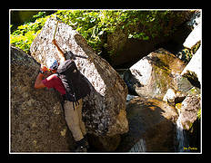 Innovative axe technique  Waterfall bouldering  Walkin' da waterfall  Pure Cascade goodness 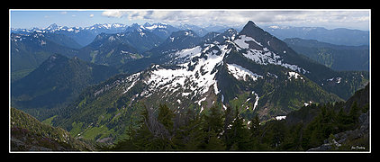 Liberty Mt. from Big Bear  Glacier Pk. 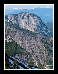 Squire Creek Wall 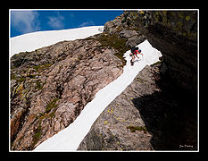 Descending Big Bear ![Climbing [i:2127e21b8f]The Thumb[/i:2127e21b8f]](thumbs/c8/ac8898dab426fe38174566c40ad2316a.jpg) Climbing The Thumb ![Top of [i:2127e21b8f]The Thumb[/i:2127e21b8f]](thumbs/84/e841f7c85b3c0dd9eeebfceb3a06dcf5.jpg) Top of The Thumb ![Descending the W face of [i:2127e21b8f]The Thumb[/i:2127e21b8f]](thumbs/cf/1cf4048cd5d4e6be978bd3986a8d16bd.jpg) Descending the W face of The Thumb 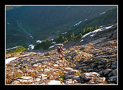 Traverse to S Finger  Traverse to S Finger  Climbing S Finger  Mt. Baker  Chopper circles the peak  Sunrise  Steep hard morning snow  Descending S finger  Traverse to Middle Finger  Descending Middle  Traverse to trail  On the way to Goat Flats 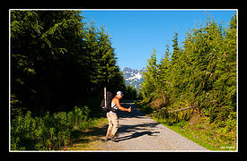 Starting the road  14 miles later  Still Buddies
|
| Back to top |
  
|
|
Magellan
Brutally Handsome

Joined: 26 Jul 2006
Posts: 13116 | TRs | Pics
Location: Inexorable descent |
|
Magellan
Brutally Handsome
|
 Fri Jul 03, 2009 9:47 am |
|
|
Holy bleep! That is some adventure. Fantastic pictures as usual! 
|
| Back to top |
|
|
run4cache
Member

Joined: 18 Jun 2006
Posts: 137 | TRs | Pics
|
I get nervous just looking at those photos! Great pictures. Cant wait to get there myself. Great job.
|
| Back to top |
|
|
Schroder
Member

Joined: 26 Oct 2007
Posts: 6719 | TRs | Pics
Location: on the beach |
|
Schroder
Member
|
Sun Jul 05, 2009 3:27 pm |
|
|
Was that approach up Copper Creek?
|
| Back to top |
|
|
Tom_Sjolseth
Born Yesterday

Joined: 30 May 2007
Posts: 2652 | TRs | Pics
Location: Right here. |
Really nice photos, thanks for the writeup!
|
| Back to top |
|
|
Jim Dockery
Member
Joined: 12 Sep 2007
Posts: 3092 | TRs | Pics
Location: Lake Stevens |
Schroder, yes we came up Copper, but went down the 3 Fingers trail (not the original plan), then had to walk the whole damn road to get out (we thought we'd only have to go about 6 miles to a washout, but the FS blocked it off way back)!
|
| Back to top |
|
|
Quark
Niece of Alvy Moore

Joined: 15 May 2003
Posts: 14152 | TRs | Pics
|
|
Quark
Niece of Alvy Moore
|
Mon Jul 06, 2009 8:14 am |
|
|
| Jim Dockery wrote: | | then had to walk the whole damn road to get out (we thought we'd only have to go about 6 miles to a washout, but the FS blocked it off way back)! |
I'll bet that was the hardest part of the trip.
"...Other than that, the post was more or less accurate."
Bernardo, NW Hikers' Bureau Chief of Reporting
"...Other than that, the post was more or less accurate."
Bernardo, NW Hikers' Bureau Chief of Reporting
|
| Back to top |
|
|
The Angry Hiker
SAR Blacklistee

Joined: 13 Jun 2008
Posts: 2890 | TRs | Pics
Location: Kentwila |
Isn't there a lookout up there? I wonder what kind of shape its in with the road being closed the past couple years.
|
| Back to top |
|
|
Shred
Member

Joined: 05 May 2009
Posts: 255 | TRs | Pics
Location: Slowhomish |
|
Shred
Member
|
Sat Jul 11, 2009 8:10 pm |
|
|
Great pictures Jim!
Can't wait to get back and finish the project!
|
| Back to top |
|
|
Tazz
Member

Joined: 27 Apr 2005
Posts: 7902 | TRs | Pics
|
|
Tazz
Member
|
Sat Jul 11, 2009 8:33 pm |
|
|
How the heck did I miss this?
where are the skis?  Good stuff you two!
|
| Back to top |
|
|
Shred
Member
Joined: 05 May 2009
Posts: 255 | TRs | Pics
Location: Slowhomish |
|
Shred
Member
|
Sat Jul 11, 2009 8:48 pm |
|
|
Well Tazz, I had big plans to ski that week... However I was indebted to Jim for skiing Rainier a few days prior. Guess its time to hang the boards up and get out some of those snaplink thinges 
|
| Back to top |
|
|
Tazz
Member
Joined: 27 Apr 2005
Posts: 7902 | TRs | Pics
|
|
Tazz
Member
|
Sat Jul 11, 2009 9:20 pm |
|
|
Oooo i like those snaplink thinges!!!

|
| Back to top |
|
|
|
|


![Climbing [i:2127e21b8f]The Thumb[/i:2127e21b8f]](thumbs/c8/ac8898dab426fe38174566c40ad2316a.jpg#275x180)

![Top of [i:2127e21b8f]The Thumb[/i:2127e21b8f]](thumbs/84/e841f7c85b3c0dd9eeebfceb3a06dcf5.jpg#275x180)
![Descending the W face of [i:2127e21b8f]The Thumb[/i:2127e21b8f]](thumbs/cf/1cf4048cd5d4e6be978bd3986a8d16bd.jpg#326x180)


